A major river basin is the land area where rain, snowmelt, groundwater, small streams, and tributaries all move toward one main river system. The basin is shaped by gravity, land slope, rock, soil, vegetation, climate, and human use. If water falls inside the basin boundary, it has a route toward that river or one of its connected channels.
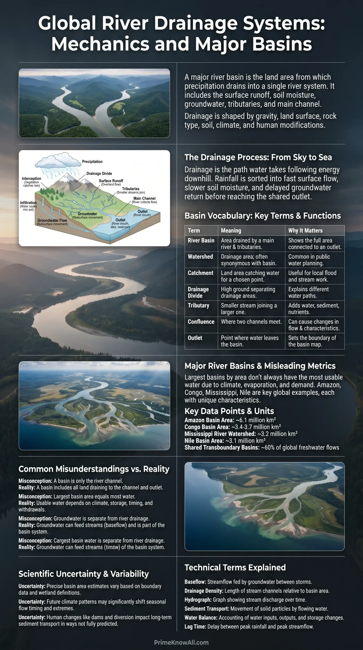
Drainage is the path water takes after it reaches the ground. Some water runs across the surface, some soaks into soil, some is held by wetlands or reservoirs, and some returns to the air through evaporation and plant transpiration. A river basin is the map-scale container for all of those movements.
If you remember one thing… a river is not only the blue line on a map. It is the visible part of a larger catchment, which is the land, slopes, channels, groundwater, and outlets that decide where water goes.
What To Remember First
- A drainage basin is defined by where water exits, such as a river mouth, lake, reservoir, or confluence.
- A drainage divide is the ridge, high ground, or subtle slope break that sends water into different basins.
- Tributaries are smaller streams and rivers that feed a larger channel.
- Large basins can include farms, cities, forests, dams, wetlands, deserts, and mountains inside one hydrologic system.
- Basin size does not automatically tell how much water flows; rainfall, evaporation, snow storage, soil, and geology also matter.
How Drainage Works in One Clear Chain
Drainage works because water follows energy downhill, moving from higher land toward lower channels until it reaches a shared outlet. The route may be fast after a storm, slow through soil, or delayed for months in snowpack and groundwater.
The chain starts with precipitation, meaning rain, snow, sleet, or hail falling from the atmosphere. After that, the basin sorts water into several paths. This sorting is why two nearby valleys can behave very differently during the same storm.
- Interception: leaves, branches, roofs, and other surfaces catch part of the rain before it reaches soil.
- Infiltration: water enters the ground through pores, cracks, roots, and loose sediment.
- Surface runoff: water moves over land when rain falls faster than the ground can take it in.
- Groundwater flow: water moves through soil and rock, then may return to streams as baseflow.
- Channel flow: small rills, streams, and tributaries gather water into larger rivers.
A simple formula helps: river flow is not just rainfall. It is rainfall minus losses and delays, plus stored water released from snow, soil, lakes, wetlands, and groundwater. That is why a river can keep flowing during dry weeks, then rise fast when a wet basin is hit by another storm.
A Short Definition That Helps Maps Make Sense
A catchment is an area of land that drains to one chosen point. If the chosen point is a small bridge, the catchment is small. If the chosen point is the mouth of the Amazon, Mississippi, Nile, or Congo, the catchment becomes continental in scale.
This is the reason basin maps can look different across textbooks, agencies, and news reports. The outlet point changes the boundary. A sub-basin, a watershed, and a river basin can all be correct if each is tied to a clear outlet.
Basin Vocabulary That Removes Confusion
River basin language is simple once each term is tied to a job. The words basin, watershed, catchment, divide, tributary, confluence, and outlet describe where water gathers, how it joins, and where it leaves.
| Term | Plain Meaning | Why It Matters |
|---|---|---|
| River Basin | The land area drained by a main river and its tributaries. | It shows the full area connected to a river outlet. |
| Watershed | A drainage area; in some countries it means the same as basin. | It is common in public water planning and school geography. |
| Catchment | The land area that catches water for a chosen outlet point. | It is useful for local flood, stream, and reservoir work. |
| Drainage Divide | High ground or a slope break that separates two drainage areas. | It explains why water on opposite sides goes to different rivers. |
| Tributary | A smaller stream or river that joins a larger one. | It adds water, sediment, nutrients, and sometimes pollution. |
| Confluence | The place where two channels meet. | It can create sudden changes in flow, width, color, and flood risk. |
| Outlet | The point where water leaves the basin being studied. | It sets the boundary of the whole basin map. |
One subtle point matters: a drainage divide is not always a dramatic mountain ridge. In flat landscapes, the divide can be a low rise, a road embankment, a dune ridge, or a small change in field slope that is hard to see from the ground.
Think of a river basin as a tilted tray with many scratches on it. Water does not move as one sheet for long; it finds the scratches, gathers into tiny lines, joins larger grooves, and leaves through the lowest edge. The tray is the basin, the scratches are channels, and the edge is the outlet.
Worth Pausing On
- Basin boundaries come from land slope, not political borders.
- The outlet point decides the scale of the basin being discussed.
- Flat areas can still have divides, even when they are hard to notice.
What Makes One Basin Different From Another
Every basin has its own drainage behavior because climate, surface shape, soil depth, bedrock, vegetation, and land use all change how water moves. A steep forest basin, a paved city basin, and a dry interior basin may react to the same amount of rain in very different ways.
The Main Controls on Drainage
- Slope: steeper land sends runoff toward channels faster, which can shorten the time between heavy rain and peak flow.
- Soil texture: sandy soil takes in water faster than compact clay in many field settings, so runoff can differ across nearby places.
- Bedrock and faults: cracks can guide groundwater, while hard rock can keep water close to the surface.
- Vegetation: roots open pathways in soil, leaves slow raindrops, and plants return water to the air.
- Climate: snowmelt basins have delayed spring flow, while monsoon basins can rise sharply during wet-season storms.
- Human surfaces: roads, roofs, drains, levees, canals, and dams can speed up, slow down, or redirect water.
Drainage density, a useful technical term, means the length of stream channels compared with the size of the basin. A basin with many closely spaced channels may move water to the river faster than a basin where water travels through soil and wetlands before it reaches a stream.
Why Shape Changes Flood Timing
Basin shape affects timing. In a rounder basin, storm runoff from many tributaries may reach the main channel within a shorter window. In a long, narrow basin, water from distant headwaters can arrive later, spreading the rise over more time. This does not predict every flood, but it helps explain why shape appears in flood studies.
- Round basin: shorter travel-time spread, sharper rise in some storm settings.
- Long basin: wider travel-time spread, more staggered tributary arrivals.
- Urban basin: fast drainage through storm drains and hard surfaces unless green storage is added.
- Wetland basin: slower release because water is stored in shallow, low-gradient areas.
Major River Basins and Why Size Can Mislead
Major river basins are large drainage systems that shape water supply, ecosystems, transport, farming, flood planning, and cross-border decisions. Size gives a first impression, but it does not tell the full story of flow, seasonality, or water stress.
The Amazon Basin is often listed as the largest drainage basin on Earth, with estimates around 6.1 million square kilometers for the basin area in many references. The Congo Basin is smaller by area but carries huge tropical river flow. The Mississippi River watershed drains about 3.2 million square kilometers across North America. The Nile Basin covers roughly 3.1 million square kilometers, yet much of it lies in dry climates where evaporation and water demand matter as much as area.
| Basin | Approximate Basin Area | Main Outlet | Drainage Lesson |
|---|---|---|---|
| Amazon | About 6.1 million km² in many basin descriptions | Atlantic Ocean | A vast wet basin can carry an enormous share of global river runoff. |
| Congo | About 3.4 to 3.7 million km², depending on boundary method | Atlantic Ocean | Equatorial rainfall and basin storage help sustain high flow. |
| Mississippi | About 3.2 million km² | Gulf of Mexico | A basin can cross many states and provinces while still draining to one outlet. |
| Nile | About 3.1 million km² in FAO material | Mediterranean Sea | A large basin can include humid headwaters and arid downstream reaches. |
| Zambezi | About 4.5% of Africa by FAO description | Indian Ocean | Dams, floodplains, and seasonal rain shape river timing. |
Area estimates vary because basin boundaries can be drawn from different datasets, different outlet choices, and different treatment of wetlands, inland sinks, lake basins, or distributary channels. Rounded numbers are safer for general readers than false precision.
Recent satellite work also shows why basin thinking matters in news about drought. During the 2023 Amazon drought, a Sentinel-1 radar study reported that mapped Rio Negro water surfaces fell to 68.1% of the maximum water surface seen in the 2022–2023 observation period. That kind of number is not just a river-gauge detail; it reflects rainfall, heat, storage, channel shape, and basin-wide water movement.
Worth Pausing On
- Large area does not always mean high usable water supply.
- Discharge depends on rainfall, evaporation, storage, and release timing.
- Rounded basin figures are more honest when sources use different boundaries.
How Water Moves Through a Basin
Water moves through a basin in layers, not only along the river surface. A storm can create overland flow in minutes, soil water in hours or days, groundwater return flow over weeks or longer, and snowmelt pulses after a whole winter of storage.
The visible river is only one part of basin drainage. In many climates, baseflow keeps streams alive between storms. Baseflow means the portion of streamflow fed by groundwater and slow subsurface movement. It is why a stream may still run after the sky has been clear for days.
From Rainfall To River Mouth
A basin drains water by sorting it into fast, slow, stored, and returned paths.
Rain or snow falls inside the divide. The same storm may feed several sub-basins at different times.
Soil, rock, roots, pavement, slope, and wetlands decide how much water runs, soaks, or waits.
Rills and streams connect to tributaries. Tributaries meet at confluences and add flow to the main river.
Snowpack, lakes, wetlands, reservoirs, floodplains, and aquifers hold water before releasing it.
The river mouth, lake, reservoir, or border gauge records the combined result of the basin.
Rule To Keep: water that falls inside the divide is connected to the basin, even when it travels underground first.
Fast Flow and Slow Flow
Fast flow happens when water quickly reaches channels. It can come from intense rain, steep slopes, saturated soil, frozen ground, or hard urban surfaces. Fast flow raises flood peaks when many tributaries send water to the main channel in a short period.
Slow flow happens when water is stored before it reaches the river. Soil, wetlands, lakes, aquifers, and floodplains can delay water. This delay can reduce sudden peaks in some basins, but it can also keep rivers high for longer after a wet season.
- Minutes to hours: runoff from roads, roofs, bare slopes, and small steep catchments.
- Hours to days: shallow soil flow and tributary response after rain.
- Days to months: groundwater return, lake release, reservoir release, and snowmelt.
- Seasonal: monsoon storage, mountain snowpack, glacier-fed flow, and wetland flood pulses.
Divides, Tributaries, and Sub-Basins
A large basin is made of smaller drainage areas nested inside it. This nested structure lets scientists, planners, and communities study a river at the right scale, from a roadside stream to a continental river mouth.
A sub-basin is a smaller basin inside a larger one. The Ohio River basin sits inside the Mississippi system, for example, and many smaller tributary basins sit inside the Ohio basin. This nested pattern is why fixing erosion in a small upstream area can affect water clarity downstream.
Why Tributaries Matter More Than They Look
- They add volume: each tributary brings water from its own catchment.
- They add sediment: sand, silt, and clay move from hillslopes and banks into channels.
- They carry chemistry: nutrients, salts, organic matter, and pollutants can enter through tributaries.
- They shape flood waves: flood peaks can stack together or arrive at different times.
- They form habitats: tributary temperature and flow help create varied river ecosystems.
Confluences are especially useful reading points. After two rivers meet, the main channel may become wider, deeper, colder, muddier, clearer, or faster. The change depends on which tributary brings more water, sediment, and energy at that moment.
Worth Pausing On
- Sub-basins make large river systems easier to study.
- Tributary timing can change how high and how fast a flood peak becomes.
- Confluences are places where river character can shift within a short distance.
Human Changes That Alter Drainage
People change basin drainage by changing surfaces, channels, storage, and water demand. These changes can help with supply and safety, but they can also move risk downstream or hide it until a wet year exposes the weak point.
Common Human Changes Inside Basins
- Urban paving: roads and roofs reduce infiltration and send water faster into drains and streams.
- Storm drains: they move water away from streets, but they can raise channel peaks if storage is limited.
- Dams and reservoirs: they store water, control releases, trap sediment, and change seasonal flow patterns.
- Levees: they protect selected areas from some floods, yet they can disconnect rivers from floodplains.
- Wetland drainage: it can lower storage and shorten the time water spends in the landscape.
- Irrigation withdrawals: they can reduce downstream flow during dry periods.
- Deforestation and soil compaction: they can alter infiltration, erosion, and sediment delivery.
None of these changes is automatically good or bad in every setting. A reservoir can reduce a flood peak during one storm and create warmer downstream water during another season. A levee can protect a neighborhood while also pushing floodwater toward a different reach. Basin thinking asks where the effect goes next.
The City Street Example
After a heavy rain, a city street can show basin drainage in miniature. Water gathers along curbs, drops through grates, enters pipes, reaches a stream, and then joins a larger river. If trash blocks a grate or a pipe is undersized, the local catchment changes from a drainage route into temporary storage on the road.
Shared Basins and Water Decisions
Many major basins cross borders, so drainage becomes a shared water issue. Upstream land use, reservoir releases, irrigation, pollution control, and flood warnings can affect people far from where a decision is made.
UN-Water material reports that 153 countries have territory within at least one transboundary river and lake basin, and that these shared waters account for about 60% of global freshwater flows. UNESCO-linked basin datasets also describe transboundary river basins covering about 42% of Earth’s land area and involving around 2.8 billion people. The exact count can change by dataset, but the message is clear: drainage rarely respects political borders.
- Flood warnings need upstream rainfall and river gauge data.
- Water supply plans need dry-season flow information, not only annual totals.
- Pollution control needs attention to tributaries, farms, factories, wastewater, and storm drains.
- Navigation and hydropower depend on release timing, channel depth, and sediment movement.
- Wetland protection depends on seasonal water pulses, not only permanent open water.
Basin-scale cooperation does not remove local needs. It connects them. A farmer near a headwater stream, a city beside a confluence, and a port at the river mouth may all use the same water system in different ways.
Worth Pausing On
- Upstream choices can change downstream flow, sediment, and water quality.
- Political borders rarely match basin boundaries.
- Shared data helps flood warnings, reservoir operations, and dry-season planning.
Reading Basin Maps Without Getting Lost
A river basin map is easier to read when the outlet, divide, tributaries, and scale are checked first. The same river can appear as a small local watershed map or a full continental basin map depending on the question being asked.
- Find the outlet: look for the river mouth, lake, reservoir, border gauge, or confluence used as the endpoint.
- Trace the divide: follow ridges, high ground, or modeled boundary lines around the drainage area.
- Look for tributary hierarchy: small streams join medium channels, then join the main river.
- Check scale: a city watershed map and a continental basin map can both be right.
- Watch for inland basins: not all drainage reaches the ocean; some ends in lakes, salt flats, wetlands, or desert sinks.
- Notice human structures: canals, dams, diversions, and drains can make water movement less obvious than natural slope alone.
Hydrologic unit codes, sometimes shortened to HUCs in the United States, are identifiers used to organize drainage areas at different sizes. A HUC is not a river name. It is a code for a mapped drainage unit, which helps agencies compare data across streams, sub-basins, and regions.
A Map Habit That Prevents Mistakes
Before reading any basin map, ask: “Drains to where?” That one question prevents many wrong interpretations. A hillside may drain to a creek, the creek to a tributary, the tributary to a main river, and the main river to the sea. Each step has a valid basin, but not the same basin.
Everyday Examples That Make Basin Drainage Easier To See
Basin drainage appears in ordinary places, from a parking lot after rain to a mountain snowfield in spring. These examples connect the map idea to things people can notice without special equipment.
- A driveway after a storm: water runs toward the lowest corner because slope gives it a preferred path.
- A neighborhood storm drain: the grate is an outlet for a tiny urban catchment, so leaves and litter can change local flooding.
- A hiking trail crossing a ridge: rain falling on one side may enter a different creek than rain falling a few steps away.
- A farm field with compacted tire tracks: water can follow the tracks instead of soaking evenly, which may speed erosion.
- A reservoir below mountains: snowmelt reaches the lake later than rainfall, so storage timing matters.
- A muddy river after construction: disturbed soil can reach tributaries if sediment controls fail during rain.
- A coastal city during high tide and rain: drainage can slow when river outlets meet elevated sea or estuary water.
- A desert wash after rare rain: channels that look dry for long periods can carry sudden runoff when intense rain falls inside the basin.
The lesson is practical: water movement is local before it becomes regional. A blocked drain, a cleared hillside, or a small wetland can influence what happens farther along the same drainage line.
Common Misconceptions About River Basins
Several basin ideas are easy to misread because everyday maps show rivers as lines, while drainage works across land surfaces and underground paths. The corrections below keep the topic grounded.
| Misconception | Better Reading | Why It Happens |
|---|---|---|
| A basin is only the river channel. | A basin includes the land that drains to the channel and outlet. | Maps often draw rivers as blue lines and leave slope invisible. |
| The largest basin always has the most usable water. | Usable water depends on climate, storage, timing, withdrawals, and quality. | Area is easier to compare than seasonal water behavior. |
| A drainage divide must be a mountain. | A divide can be a low ridge, subtle rise, dune, or engineered feature. | Textbook diagrams prefer bold ridgelines. |
| Groundwater is separate from river drainage. | Groundwater can feed streams and be part of basin flow. | Underground movement is hard to see directly. |
| Flooding is only a riverbank problem. | Flooding can start with runoff, blocked drains, saturated soil, or tributary timing. | News images often focus on the main river after it rises. |
Worth Pausing On
- Drainage maps show land-to-water connection, not only rivers.
- Groundwater can be part of streamflow, especially between storms.
- Flood behavior depends on the whole basin, not just the main channel.
Quick Test
Use these short checks to see whether the basin idea is clear. Open each answer and test the reasoning, not only the wording.
A raindrop lands on the west side of a low ridge and reaches River A, while a raindrop on the east side reaches River B. What is the ridge doing?
The ridge is acting as a drainage divide. It separates two drainage areas by sending water toward different outlets.
A small creek joins a larger river after draining farms and woods. What role does the creek play?
The creek is a tributary. It adds water, sediment, and dissolved material from its own catchment to the larger river.
A city gets heavy rain, and water reaches the stream faster than it did before the area was paved. What changed?
The paved surfaces reduced infiltration and increased faster runoff through streets and storm drains.
A river keeps flowing during a dry week with no rain. Where can some of that water come from?
Some of it can come from baseflow, which is slow water released from soil, shallow groundwater, wetlands, or connected storage.
A map shows the same river with two different basin boundaries. Can both maps be correct?
Yes, if they use different outlet points or drainage-unit scales. A basin boundary depends on the point chosen for analysis.
Limits of This Explanation
River basin explanations are best read as a model of real drainage, not a perfect copy of every landscape. Natural basins can include wetlands, karst springs, disappearing streams, artificial canals, glacier storage, reservoirs, tidal reaches, and border definitions that complicate a clean boundary line.
- Area numbers can differ because agencies and reference works may use different boundary datasets.
- Groundwater boundaries do not always match surface-water divides exactly, especially in limestone and fractured rock.
- Human diversions can move water across natural divides through canals, tunnels, pipelines, or irrigation systems.
- Flood estimates need local rainfall, soil moisture, channel capacity, land cover, and infrastructure data.
- Climate patterns can shift flow timing, so old averages may not describe a recent drought or flood season well.
Major river basins explain how land drains, how tributaries connect, and why upstream choices appear downstream. They also show why a river cannot be understood by its channel alone.
The common mistake is treating basin size as the whole story. The rule to keep is simple: start with the outlet, trace the divide, then ask how water is stored, delayed, used, and released.
Sources
- U.S. Geological Survey – Watersheds and Drainage Basins — Useful for definitions of watershed, drainage basin, drainage divide, and the idea that larger watersheds contain smaller watersheds. USGS is a federal science agency with long-running water education and monitoring programs.
- U.S. Geological Survey – Hydrologic Units — Supports the explanation of hydrologic units and drainage-unit mapping. It is reliable because it describes the national hydrologic unit system used by U.S. water agencies.
- NOAA – The Water Cycle — Supports the plain-language discussion of precipitation, infiltration, runoff, and water movement. NOAA is an official U.S. science agency focused on weather, oceans, climate, and water education.
- NASA Global Precipitation Measurement – The Water Cycle — Useful for connecting rainfall, land storage, rivers, lakes, and oceans. NASA’s GPM education material is tied to satellite observation of precipitation.
- National Park Service – Mississippi River Facts — Supports the Mississippi watershed area and its reach across U.S. states and Canadian provinces. NPS material is official and location-specific to the Mississippi National River and Recreation Area.
- FAO – Nile Basin, Water Resources Management — Supports the Nile Basin area and transboundary water context. FAO is a United Nations agency with specialist water and agriculture material.
- UN-Water – Progress on Transboundary Water Cooperation 2021 Update — Supports figures on countries and shared river, lake, and aquifer systems. UN-Water coordinates United Nations work on freshwater and sanitation.
- UNESCO IHP-WINS – Transboundary River Basins Around the World — Supports dataset-style figures on transboundary basin area, population, and discharge. It is reliable because it is tied to UNESCO’s Intergovernmental Hydrological Programme.
- Wagner et al. – Amazon’s 2023 Drought: Sentinel-1 Reveals Extreme Rio Negro River Contraction — Supports the Rio Negro drought example and the 68.1% mapped water-surface figure. It is useful as an academic preprint using satellite radar methods, though it should be read with normal preprint caution.
- National Geographic Education – Drainage Basin — Helps confirm general reader definitions of watershed, tributary, runoff, and river system. It is a trusted educational reference written for school and public learning.
- Encyclopaedia Britannica – Drainage Basin — Useful for concise reference definitions and examples. Britannica is a long-running edited reference source.
- Encyclopaedia Britannica – Amazon Basin — Supports the rounded Amazon Basin area and the idea that the Amazon is the largest drainage basin. It is an edited reference page with geography-focused review.
FAQ
What Is a Major River Basin?
A major river basin is a large land area drained by a main river and its tributaries. It can cross regions, countries, climate zones, and ecosystems before reaching an outlet such as an ocean, sea, lake, or inland sink.
How Does a Drainage Basin Work?
A drainage basin works by collecting precipitation and moving it through surface runoff, soil water, groundwater, wetlands, tributaries, and the main river. Gravity guides the overall movement toward the outlet, while storage and land cover affect timing.
What Is the Difference Between a Watershed and a River Basin?
The terms are sometimes used in the same way. In many public water resources contexts, watershed can mean any drainage area, while river basin often refers to a larger river system. The clearest method is to name the outlet point.
Why Do River Basin Boundaries Matter?
River basin boundaries matter because they show which lands are hydrologically connected. They help explain flood risk, pollution movement, water supply, sediment transport, habitat links, and upstream-downstream effects.
Can a River Basin Cross Country Borders?
Yes. Many large basins cross national borders. The Nile, Mekong, Danube, Amazon, Congo, Indus, and many other systems involve more than one country, which makes shared data and water cooperation important.
Does a Bigger Basin Always Have More Water?
No. Basin area matters, but water availability also depends on rainfall, evaporation, snow and ice storage, groundwater, vegetation, dams, withdrawals, and seasonal timing. A large dry basin can have less available flow than a smaller wet basin.
What Is a Drainage Divide?
A drainage divide is the boundary that separates where water flows. Water falling on one side moves toward one basin, while water falling on the other side moves toward a different basin.