Skip to content
Desert landscape with vast orange sand dunes on the left and snow-covered cold desert on the right.

The World’s Largest Deserts: Hot and Cold Deserts

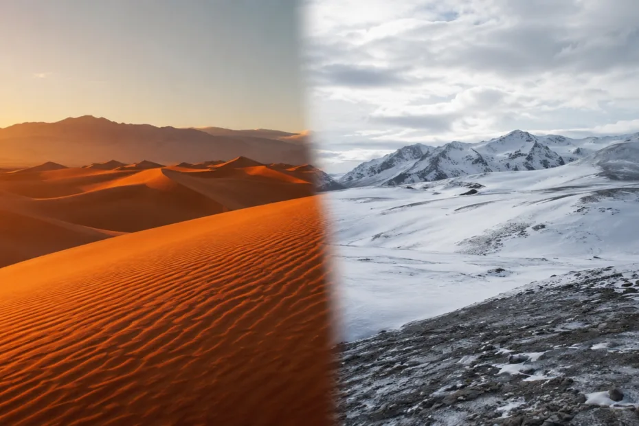
The world’s largest desert is Antarctica, not the Sahara, because a desert is defined mainly by dryness, not heat. The Arctic Desert ranks second, and the Sahara is the largest hot desert on Earth. Deserts are places where water is scarce for plants, soils, rivers, animals, and people.… 

Sharp mountain peaks rise against a partly cloudy sky with green valleys below.

How Mountains Form: Fold, Fault-Block, Volcanic

Ultra-Short Answer Mountains form when Earth’s crust is compressed, pulled apart, or built up by eruptions. The three classic outcomes are fold mountains (crumpled layers), fault-block mountains (tilted/raised blocks), and volcanic mountains (piled-up lava and ash). What To Remember In One Minute Mountains are not “just tall rocks”—they… 

Stratovolcano with a steep, symmetrical shape and snow-capped summit rises above surrounding landscape.

Types of Volcanoes: Shield, Stratovolcano, Cinder Cone

Scrollable Infographic: Shield, Stratovolcano, Cinder Cone A realistic, field-friendly way to read volcano shapes: viscosity + gas + erupted material. Scroll inside the panel to explore. Shield broad, flow-built Stratovolcano layer-built Cinder Cone fragment-built Key idea shape follows flow Jump to: pick a block, then keep scrolling for… 

Volcanoes erupting with lava flowing down, illustrating formation at hotspots and plate boundaries.

How Volcanoes Form: Hotspots and Plate Boundaries

Volcanoes form when hot rock melts and that melt finds a way to the surface—most commonly at plate boundaries or above hotspots that feed magma through the middle of a plate. In practice, the “why” is usually about how melting starts (pressure drops, water is added, or extra… 

A graph showing earthquake magnitude levels and a photo of damaged buildings in an earthquake.

Earthquake Basics: Magnitude vs Intensity

Earthquakes often get described with two different kinds of numbers: magnitude and intensity. They sound similar, but they answer different questions. Magnitude describes the size of the earthquake at its source. Intensity describes the strength of shaking at a specific place. Understanding this difference helps people read alerts,… 

Volcanic eruption between tectonic plates with flowing lava and rocky landscape

Tectonic Plates Explained: How Earth’s Crust Moves

Earth’s surface looks solid, but it is built from moving pieces called tectonic plates. These slabs of the lithosphere (crust plus the uppermost mantle) slide over a softer layer beneath, reshaping continents, building mountains, opening oceans, and triggering earthquakes. Plate tectonics is the unifying theory that explains why… 

A whale's tail rises out of the ocean waves during sunset by shallow coral reefs.

Oceans of the World: Names, Depth, and Key Facts

Earth has one connected global ocean, but for navigation, science, and everyday language it’s often described as five major ocean basins: the Pacific, Atlantic, Indian, Southern, and Arctic. Each one has its own shape, depth profile, and signature role in climate and ecosystems—yet all are linked by currents… 

A colorful map showing the continents of the world with a compass and a globe nearby.

Continents of the World: Names, Size, and Key Facts

Continents are Earth’s biggest land regions—huge, varied spaces where geology, climate, and human history interact on a planetary scale. When people say “the continents,” they usually mean seven broad areas: Asia, Africa, North America, South America, Antarctica, Europe, and Australia (often grouped with the wider region called Oceania).…