
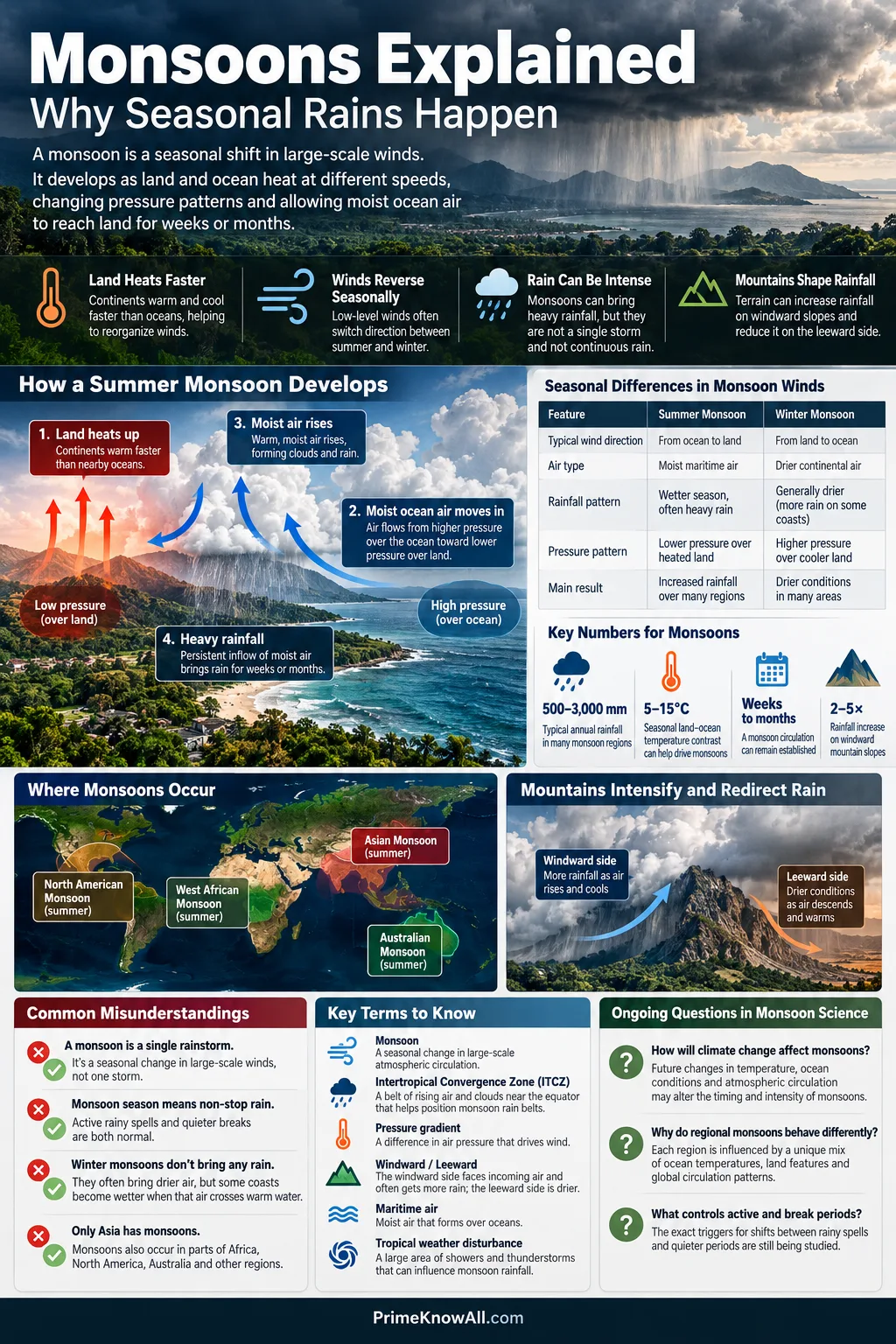
A monsoon is a seasonal shift in large-scale winds, not a single rainstorm. Seasonal heating moves tropical rain belts and changes pressure patterns, allowing moist ocean air to reach land for weeks or months. The rain can be intense, but the defining feature is the change in atmospheric circulation.
The familiar summer pattern begins when continents warm faster than nearby oceans. That contrast helps reorganize winds, while the Intertropical Convergence Zone (ITCZ), Earth’s rotation, ocean temperatures, mountains and tropical weather disturbances shape where the moisture goes and where rain actually falls.
- Summer monsoons often carry moist maritime air toward land and create a wet season.
- Winter monsoons often reverse the low-level flow and favor drier continental air, though some coasts become wetter after that air crosses warm water.
- A monsoon season is not continuous rain; active spells and quieter breaks are normal parts of several regional monsoon systems.
- Mountains can sharply increase rainfall on windward slopes and reduce it on the leeward side.
A Monsoon Is a Wind Shift, Not a Giant Storm
The word monsoon comes from the Arabic mausim, meaning season. Meteorologists use the term for seasonal winds and the circulation changes tied to them. Heavy rain is one possible result, especially in summer, but rain alone does not define a monsoon.
This distinction explains why a thunderstorm can happen during monsoon season without being “the monsoon” itself. A thunderstorm may last an hour. A tropical cyclone may last days. A monsoon is a regional circulation pattern that can remain established for months.
The useful distinction
- Monsoon: a seasonal change in large-scale circulation.
- Rainy season: any part of the year when rainfall is higher, whether or not winds reverse.
- Storm: an individual weather event embedded within the larger circulation.
Why Land and Ocean Heat at Different Speeds
The basic seasonal contrast starts with a simple property of Earth’s surface: land changes temperature faster than the ocean. Soil and rock store and redistribute heat differently from water, while ocean mixing and evaporation spread incoming energy through a much larger volume.
During summer, a large continent can therefore become much warmer than a neighboring ocean. The atmosphere responds to the resulting temperature and pressure differences. In winter, the land loses heat faster, so the contrast can reverse.
Why Water Responds More Slowly
Ocean water has a high heat capacity, mixes vertically, and loses energy through evaporation. Sunlight can also warm a layer of water rather than only the immediate surface. Over land, heat is concentrated much closer to the ground. These differences help create a larger seasonal temperature swing over continents.
How the Temperature Contrast Changes Pressure
Warm continental air expands the atmospheric column and supports rising motion in regions where low-level air converges. Cooler regions favor different pressure patterns. Air then accelerates in response to the pressure gradient, but its path is modified by Earth’s rotation, terrain and the surrounding circulation.
A sea breeze is a useful first analogy: coastlines can develop an onshore wind because land heats faster than water during the day. A monsoon is far larger and lasts much longer, so the analogy only goes so far. Seasonal tropical circulation and migrating rain belts are part of the full explanation.
Modern monsoon research therefore treats the land–sea temperature contrast as one part of a planetary-scale seasonal circulation, not a complete cause by itself. The seasonal migration of tropical convergence, ocean temperature patterns and regional topography can all alter the circulation, which is why monsoons do not behave like identical oversized sea breezes.
| Feature | Summer Monsoon | Winter Monsoon |
|---|---|---|
| Land relative to ocean | Warmer in many monsoon regions | Cooler in many monsoon regions |
| Low-level flow | Often carries maritime air toward land | Often carries continental air outward |
| Moisture supply over land | Often higher | Often lower |
| Typical result | Wet season in many regions | Drier season in many regions |
| Important exception | Terrain can leave some areas dry | Air crossing warm water can produce coastal rain |
Why the ITCZ Moves With the Seasons
The Intertropical Convergence Zone is a broad belt where low-level winds from the Northern and Southern Hemispheres come together. Air rises there, clouds grow deeply, and tropical rainfall is frequent. Its position shifts north and south through the year rather than staying fixed at the equator.
The Met Office notes that the ITCZ follows the seasonal migration of strongest solar heating with a delay of roughly one to two months. Because land warms and cools faster than the ocean, the rain belt tends to move farther north and south over continents than over open water.
The Summer Rain Belt Can Move Far Onto Land
During Northern Hemisphere summer, strong heating shifts tropical convergence northward over parts of Africa and Asia. Moist air from lower latitudes is drawn toward this zone of rising air. During Southern Hemisphere summer, the broad pattern moves southward and helps bring monsoon conditions to northern Australia and other tropical regions south of the equator.
Coriolis Turns the Cross-Equatorial Flow
Air does not travel in a straight line from high pressure to low pressure. Earth’s rotation creates the Coriolis effect, deflecting moving air to the right in the Northern Hemisphere and to the left in the Southern Hemisphere. When low-level air crosses the equator toward a summer monsoon region, this change in deflection can help turn the flow into the familiar monsoon wind directions.
How the Monsoon Chain Develops
1. Seasonal sunlight shifts
One hemisphere receives stronger summer heating, moving the tropical zone of rising air away from the equator.
2. Continents warm faster
Large land areas develop a stronger summer temperature contrast with nearby oceans.
3. Pressure and wind patterns reorganize
Low-level air begins moving toward the heated continent and tropical convergence zone.
4. Ocean air supplies water vapor
Persistent flow over warm seas transports moisture inland.
5. Convergence and terrain lift the air
Rising moist air expands, cools and reaches saturation.
6. Clouds release heavy seasonal rain
Condensation, deep convection and repeated moisture supply allow wet spells to recur.
Why Monsoon Rain Can Become So Heavy
A monsoon becomes very wet when the circulation can repeatedly deliver warm, humid air from ocean to land and provide a way for that air to rise. The important point is persistence: the moisture supply can be renewed day after day instead of being exhausted by one storm.
Convergence Feeds Rising Air
Where low-level winds meet, air cannot continue piling up near the ground. Some of it rises. As moist air climbs into lower pressure, it expands and cools. Once it reaches saturation, water vapor condenses into cloud droplets and ice particles, setting the stage for rain.
Deep Convection Builds Tall Storm Clouds
Hot, humid air can become buoyant enough to rise through a deep part of the troposphere. The resulting cumulonimbus clouds may produce intense rain, lightning and strong localized winds. The Met Office reports that thunderstorms along the ITCZ can sometimes reach or exceed about 16 kilometers (55,000 feet) in height.
Condensation Releases Latent Heat
When water vapor condenses, it releases latent heat into the surrounding air. That heat can support buoyancy and help maintain deep tropical convection. Monsoon rainfall therefore both responds to the circulation and feeds energy back into it.
How Mountains Reshape Monsoon Rainfall
Mountains do not create an entire monsoon by themselves, but they can strongly control where the rain is released. Moist flow forced up a slope cools as it rises, which favors condensation and heavier precipitation on the windward side.
Orographic Lift Creates Wet and Dry Sides
The process is called orographic lift. Windward slopes can receive much more rain than nearby lowlands, while descending air on the leeward side warms and dries. This is why one monsoon circulation can produce lush mountain slopes and a much drier rain-shadow region within a relatively short distance.
South Asia shows the effect clearly. Moisture from the Arabian Sea and Bay of Bengal interacts with the Western Ghats, Himalayan foothills and Tibetan Plateau, creating steep rainfall contrasts that cannot be explained by latitude alone.
The Himalayas are more than a cloud barrier
- They force air upward along steep terrain and alter regional moisture transport.
- They also help separate warm, moist South Asian air from colder, drier air farther north.
- The relative roles of terrain, plateau heating and large-scale monsoon flow vary by season and remain active research topics.
What a 2026 Himalayan Study Added
A 2026 study in npj Climate and Atmospheric Science used satellite-derived latent-heating profiles, reanalysis data and weather-model experiments along the southern Tibetan Plateau. In spring, the height of peak latent heating closely followed the terrain. During summer, it became much less tied to the slope and remained near 5–6 kilometers across much of the transect.
The study supports a seasonal shift in control: local terrain forcing is more visible before the South Asian summer monsoon is established, while large-scale monsoon moisture transport dominates more strongly in summer. That finding also shows why describing the Himalayas as a simple wall that “stops clouds” misses much of the physics.
Why a Monsoon Can Start So Suddenly
Monsoon onset can feel abrupt because several atmospheric features can change together: low-level winds strengthen or reverse, humidity rises, deep cloud cover expands, and organized rain spreads over a wider area. The first shower is not automatically the onset of the monsoon.
Meteorological agencies therefore use regional criteria rather than a single rainy day. In India, for example, monsoon monitoring considers rainfall distribution along with larger circulation and moisture patterns. The same principle applies elsewhere: onset describes a change in the seasonal atmospheric regime, not merely the arrival of one storm.
Why Monsoon Season Does Not Mean Rain Every Day
Monsoon rainfall comes in pulses. A wet season may alternate between active phases, when broad areas receive frequent rain, and break or inactive phases, when rainfall drops over part of the monsoon region even though the season itself is still underway.
Active and Break Cycles Shift the Rain Belt
During an active phase, convergence, moisture transport and organized convection favor widespread rainfall. During a break, the main rain belt or monsoon trough can weaken or move, leaving one area drier while rainfall increases somewhere else. A “break” therefore does not mean that the entire monsoon system has disappeared.
Northern Australia offers a clear measured example. The Australian Bureau of Meteorology describes wet seasons with about two to four active–inactive cycles, with a full cycle often lasting roughly four to eight weeks. Those numbers are regional, not a universal schedule for every monsoon.
The Madden–Julian Oscillation Can Help Organize Wet and Dry Spells
The Madden–Julian Oscillation (MJO) is a large eastward-moving pattern of tropical cloudiness, rainfall and atmospheric circulation. Its phases can favor or suppress convection over a monsoon region for periods of days to weeks. India’s meteorological service lists the MJO among the influences on the active–break cycle of the South Asian monsoon.
A wet season can still contain long dry spells
- Seasonal rainfall totals do not show when the rain fell.
- A few very wet spells can coexist with lengthy quieter periods.
- Two places under the same monsoon can experience very different rainfall because the rain belt shifts.
Why Winter Monsoons Are Not Always Dry
Winter monsoon flow often begins over a cool continent, so it can be much drier than summer maritime air. Yet wind direction matters as much as the season label. If that air crosses a warm sea before reaching another coast, it can pick up moisture and produce substantial rain.
Southeastern India is a good example. The India Meteorological Department identifies October through December as the northeast monsoon season for parts of southern peninsular India. For the Tamil Nadu meteorological subdivision, the department’s current normal places about 48% of annual rainfall in those three months. This is why “winter monsoon equals dry weather” is too broad a rule.
Why Monsoons Differ Around the World
Monsoons share a seasonal circulation pattern, but each regional system has its own coastlines, mountain ranges, ocean temperatures and tropical circulation. A South Asian monsoon should not be treated as a template that every other monsoon follows.
- South Asia: strong cross-equatorial moisture transport from the Indian Ocean interacts with the subcontinent, Western Ghats and Himalayas.
- East Asia: the seasonal rain belt interacts with the western Pacific, continental Asia and migrating frontal zones.
- West Africa: seasonal circulation brings Atlantic moisture inland toward tropical West Africa and the Sahel.
- North America: summer circulation carries moisture toward northwestern Mexico and the U.S. Southwest, helping fuel thunderstorms.
- Northern Australia: northwesterly monsoon flow, a monsoon trough and repeated active–inactive phases shape the tropical wet season.
- South America: a broad austral-summer monsoon circulation affects much of tropical and subtropical South America, although its wind reversal is not identical to the classic South Asian pattern.
NOAA notes that the North American monsoon usually develops first in Mexico during June and reaches the U.S. Southwest during July, before the dominant wind pattern generally shifts back by September. It is a useful reminder that monsoons are not confined to India or Southeast Asia.
Why One Monsoon Year Differs From the Next
The seasonal cycle returns each year, but the amount, timing and distribution of rain vary. Monsoons interact with ocean temperatures, tropical circulation patterns, soil and snow conditions, aerosols and shorter-lived weather systems. No single index explains every wet or dry year.
El Niño and La Niña Change the Background Circulation
El Niño–Southern Oscillation (ENSO) changes tropical Pacific sea-surface temperatures and the surrounding atmospheric circulation. Those changes can alter monsoon behavior far from the Pacific. The relationship is probabilistic rather than automatic: an El Niño event does not guarantee drought in every monsoon region, and La Niña does not guarantee flooding.
The Indian Ocean Dipole Alters East–West Ocean Conditions
The Indian Ocean Dipole (IOD) describes a changing east–west pattern of sea-surface temperatures in the tropical Indian Ocean. It can modify moisture transport and rainfall around the Indian Ocean basin, sometimes reinforcing and sometimes offsetting other influences such as ENSO.
Sea-Surface Temperature Sets the Moisture Reservoir
Warm water supports evaporation, supplying water vapor to the lower atmosphere. Yet warmer water alone does not guarantee heavy rain over land. Winds still have to transport the moisture, converge it and lift the air in the right place.
Why Total Rainfall Can Hide Drought and Flood Risk
A season can finish close to its usual rainfall total while still producing serious water problems. Timing and distribution matter. Ten very wet days followed by a long dry spell do not have the same effect on soil, crops, rivers or reservoirs as the same total spread evenly across many weeks.
- Short, intense bursts can overwhelm drainage and increase runoff.
- Long breaks can dry soils even during an otherwise normal wet season.
- Mountain rainfall can raise rivers far downstream from where the rain fell.
- Rain-shadow areas may stay comparatively dry while nearby windward slopes receive repeated heavy rain.
This is why seasonal precipitation totals should not be read as a complete measure of monsoon behavior. Rainfall intensity, number of wet days, length of dry spells and geographic distribution all describe different parts of the season.
How Climate Change Is Altering Monsoon Rain
A warmer atmosphere can contain more water vapor, which can raise the amount of moisture available to storms. That does not mean every monsoon region will simply become wetter. Rainfall also depends on circulation strength, ocean patterns, aerosols, terrain and where convergence zones move.
The IPCC assesses that monsoon land precipitation is likely to rise over East, Southeast and South Asia as warming increases atmospheric moisture and moisture convergence, while the size and local pattern of the change remain less certain in some areas. For South Asia, the IPCC also projects higher summer monsoon precipitation later this century, alongside greater year-to-year variability.
The distinction between circulation and rainfall matters here. A monsoon circulation can weaken in some model projections even while rainfall grows because the air carries more water vapor. Changes in aerosols add another layer of uncertainty, especially across densely populated parts of Asia.
What Scientists Still Cannot Pin Down
Monsoon physics are well established at the broad scale, but regional rainfall details remain difficult to predict. Mountain terrain is hard for global climate models to represent, ocean–atmosphere interactions can reinforce or cancel one another, and active–break cycles develop on time scales that sit between daily weather and seasonal climate.
Even the role of the Tibetan Plateau is not reduced to one mechanism. Research continues to separate the effects of mechanical blocking, slope uplift, elevated-surface heating and moisture transport at different heights. The 2026 satellite study described earlier adds direct observational evidence, but it does not turn the whole Asian monsoon into a single-process system.
How the Same Physics Appears in Real Places
The monsoon mechanism becomes easier to recognize when the circulation is connected to actual landscapes.
- Western India: moist summer flow from the Arabian Sea reaches the Western Ghats and is forced upward, producing wetter windward slopes and drier conditions farther inland.
- Himalayan foothills: monsoon moisture meets steep terrain, so lifting can concentrate rainfall along the southern mountain margins.
- Tamil Nadu: the southwest summer monsoon leaves parts of the southeast in a rain shadow, while the later northeast monsoon brings a large share of annual rain after flow crosses the Bay of Bengal.
- Arizona and New Mexico: the North American monsoon raises summer humidity and thunderstorm activity as the regional circulation draws moisture northward.
- Northern Australia: the wet season can switch between broad rainy active phases and quieter inactive phases as the monsoon trough moves.
- The Sahel: the northward seasonal reach of moist West African monsoon air helps set the short summer rainy season across this semi-arid belt.
Monsoon, Rainy Season and Tropical Cyclone Are Different
These terms overlap in everyday conversation, but they describe different atmospheric phenomena. A monsoon is a seasonal circulation; a rainy season is a period on the calendar; a tropical cyclone is a rotating storm system.
| Term | What It Describes | Typical Scale | Seasonal Wind Change Part of the Definition? |
|---|---|---|---|
| Monsoon | Seasonal change in regional circulation and rainfall | Regional to continental | Yes, in the meteorological sense |
| Rainy season | Part of the year with higher rainfall | Local to regional | No |
| Thunderstorm | Convective storm cloud and associated weather | Local | No |
| Tropical cyclone | Organized rotating low-pressure storm over warm ocean | Hundreds of kilometers | No |
Tropical cyclones can occur during a monsoon season and may add large amounts of rain, but they are separate weather systems. Likewise, a place can have a pronounced rainy season without meeting the circulation-based definition of a monsoon.
Questions About Monsoons
Does monsoon mean heavy rain?
No. A monsoon is a seasonal change in large-scale winds and circulation. Heavy rain often accompanies the summer phase because the flow can carry moist ocean air over land, but the winter phase can be dry.
Why does land heat faster than the ocean?
Land stores heat in a relatively shallow layer, while ocean water has a high heat capacity, mixes vertically and loses energy through evaporation. The ocean therefore changes temperature more slowly through the seasons.
Does it rain every day during monsoon season?
No. Monsoon seasons contain active wet spells and quieter breaks. The length and timing of those phases vary by region and year.
Can a winter monsoon cause heavy rain?
Yes. If winter monsoon air crosses warm ocean water before reaching land, it can gain moisture. Southeastern India receives much of its annual rainfall during the October–December northeast monsoon.
Are monsoons only found in Asia?
No. Monsoon circulations also affect parts of Africa, Australia, North America and South America. Their timing and wind patterns differ because each region has different oceans, continents and mountain ranges.
The most accurate way to picture a monsoon is as a seasonal reorganization of tropical circulation. Land–ocean heating contrast helps set it up, the ITCZ and Earth’s rotation shape the flow, oceans supply moisture, and terrain helps decide where that moisture becomes rain.
Sources
- NOAA NESDIS – What Is a Monsoon? NOAA explains the seasonal wind shift, summer and winter monsoons, and the North American monsoon using established meteorological concepts.
- Met Office – Intertropical Convergence Zone The UK national weather service describes ITCZ migration, tropical convergence and the seasonal movement of deep rainfall.
- India Meteorological Department – Monsoon India’s national meteorological service provides operational definitions, onset and withdrawal criteria, rainfall monitoring and monsoon terminology. Its Northeast Monsoon 2025 report documents the October–December season and the share of annual rainfall received by Tamil Nadu.
- Australian Bureau of Meteorology – Monsoon Australia’s national weather agency documents monsoon onset, the monsoon trough and measured active–inactive cycles in northern Australia.
- IPCC AR6 Working Group I – Chapter 10: Linking Global to Regional Climate Change The assessment summarizes observed and projected changes in Asian monsoon rainfall using multiple lines of climate evidence.
- npj Climate and Atmospheric Science – Satellite Latent Heating Retrievals Uncover a Seasonal Terrain-Monsoon Seesaw in Southern Tibetan Plateau Rainfall This peer-reviewed 2026 study uses satellite retrievals and modeling to examine how terrain and large-scale monsoon circulation influence Himalayan precipitation in different seasons.
- Reviews of Geophysics – Monsoons, ITCZs, and the Concept of the Global Monsoon This peer-reviewed review explains why modern monsoon theory goes beyond a simple continent-scale sea-breeze model.
- American Meteorological Society – Monsoon The AMS Glossary of Meteorology is a specialist reference for the formal meteorological meaning of monsoon and related circulation terms.