The Nile is commonly listed as the world’s longest river at about 6,650 km, while the Amazon follows close behind at about 6,400 km in many standard reference tables. River length is not as simple as tracing one blue line on a map. It depends on which source is counted, which tributary chain is included, and where a wide delta or estuary is treated as the mouth.
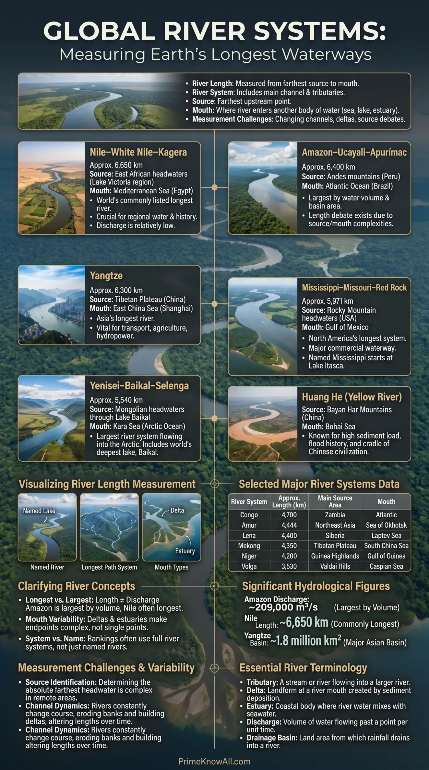
If you remember one thing: a “longest river” ranking is really a ranking of measured river systems, not just named rivers. That is why the Mississippi can appear shorter by itself, but much longer when the Missouri and Red Rock headwaters are included.
What To Notice First
The best way to read a longest-rivers list is to look at three fields together: length, source, and mouth. A number without those two map points can be misleading.
- Length is usually rounded because river channels move, split, and bend.
- Source can mean the named river’s start or the farthest upstream headwater in the whole system.
- Mouth can be a single outlet, a delta, an estuary, a lake, an inland sea, or the ocean.
- River system means the main river plus the tributary chain used to measure its longest path.
- Longest does not mean highest water flow; the Amazon carries far more water than the Nile.
Plain Reading Rule
- Use river system names when comparing global rankings.
- Treat exact lengths as well-supported estimates, not fixed survey pins.
- Check whether a list measures from the named source or the farthest headwater.
How River Length Is Measured
River length is measured from a chosen source to a chosen mouth along the channel path. That sounds tidy, but rivers are not straight measuring tapes. They have tributaries, seasonal channels, braided reaches, deltas, reservoirs, floodplains, and mouths that can spread across many kilometers.
A source is the upstream point from which a river system is measured. A tributary is a smaller river or stream that feeds a larger one. A mouth is the place where a river releases its water into another body of water, such as a sea, ocean, lake, estuary, or another river.
- Named-river method: measures only the river that carries the main name, such as the Mississippi from Lake Itasca.
- Longest-path method: follows the farthest connected headwater, such as the Mississippi–Missouri–Red Rock system.
- Hydrologic method: may favor drainage, flow, slope, and water continuity rather than familiar names.
- Cartographic method: depends on map scale, satellite data, channel centerlines, and how bends are digitized.
One useful analogy: measuring a long river is like measuring the longest route through a city’s connected streets. The main avenue may have one official start, but the farthest connected road, ramp, or service lane may extend the route. Both answers can be correct if the measuring rule is stated.
The Longest River Systems Ranked By Length
The table below uses widely cited reference lengths and treats major entries as river systems where that is the common ranking method. Figures are rounded because source choice, channel mapping, and delta endpoints can shift the final number.
| Rank | River System | Approx. Length | Main Source Area | Mouth |
|---|---|---|---|---|
| 1 | Nile–White Nile–Kagera | 6,650 km / 4,132 mi | East African headwaters linked with the Lake Victoria and Kagera system | Mediterranean Sea, Egypt |
| 2 | Amazon–Ucayali–Apurímac | 6,400 km / 4,000 mi | Andes of southern Peru; exact farthest source is debated | Atlantic Ocean, northern Brazil |
| 3 | Yangtze | 6,300 km / 3,915 mi | Tibetan Plateau, Qinghai region of China | East China Sea near Shanghai |
| 4 | Mississippi–Missouri–Red Rock | 5,971 km / 3,710 mi | Upper Red Rock and Missouri headwaters in the Rocky Mountain region | Gulf of Mexico via the Mississippi Delta |
| 5 | Yenisey–Baikal–Selenga | 5,540 km / 3,442 mi | Selenga headwaters in Mongolia, through Lake Baikal and the Angara | Kara Sea, Arctic Ocean |
| 6 | Huang He / Yellow River | 5,464 km / 3,395 mi | Bayan Har Mountains, Qinghai, China | Bo Hai / Bohai Sea |
| 7 | Ob–Irtysh | 5,410 km / 3,362 mi | Altai region and Irtysh headwaters | Gulf of Ob, Kara Sea, Arctic Ocean |
| 8 | Paraná | 4,880 km / 3,032 mi | Paranaíba and Grande river system, Brazil | Río de la Plata estuary, Atlantic Ocean |
| 9 | Congo–Lualaba–Chambeshi | 4,700 km / 2,900 mi | Chambeshi headwaters, northeastern Zambia | Atlantic Ocean |
| 10 | Amur–Argun | 4,444 km / 2,761 mi | Argun and related headwaters near northeast Asia’s borderlands | Sea of Okhotsk region |
| 11 | Lena | 4,400 km / 2,734 mi | Mountains west of Lake Baikal, Siberia | Laptev Sea, Arctic Ocean |
| 12 | Mekong | 4,350 km / 2,700 mi | Tibetan Plateau | South China Sea through the Mekong Delta |
| 13 | Mackenzie–Slave–Peace | 4,241 km / 2,635 mi | Finlay and Peace headwaters in western Canada | Beaufort Sea, Arctic Ocean |
| 14 | Niger | 4,200 km / 2,600 mi | Guinea Highlands near the Sierra Leone border | Gulf of Guinea, Atlantic Ocean |
| 15 | Volga | 3,530 km / 2,193 mi | Valdai Hills, Russia | Caspian Sea |
Notice the pattern: several entries are not single-name rivers. They are connected systems measured from the farthest headwater to the final outlet. That is why a careful table says Amazon–Ucayali–Apurímac or Yenisey–Baikal–Selenga instead of only Amazon or Yenisey.
Map Reader Note
- The Nile, Amazon, and Yangtze remain the top three in many reference lists.
- The Amazon–Nile order can change in studies that choose a different Amazon source or mouth.
- A table is strongest when it shows method, not just rank.
River-By-River Notes
Each long river has a different reason for being hard to summarize. Some cross many countries, some end in broad deltas, and some become long only when their farthest tributary chain is counted.
Nile River
The Nile is commonly given as about 6,650 km long and flows north into the Mediterranean Sea. Its source is often described through the White Nile, Lake Victoria, and the Kagera river system, while the Blue Nile brings much of the water that reaches Sudan and Egypt.
- Source issue: several upstream streams in the Lake Victoria basin can be discussed as the farthest headwater.
- Mouth: the Nile Delta spreads into the Mediterranean on Egypt’s coast.
- Reader note: its length ranking is famous, but its discharge is far lower than the Amazon’s.
Amazon River
The Amazon is commonly listed near 6,400 km, but some measurements make it longer depending on the chosen Andean source and Atlantic mouth. It is also the planet’s largest river by water volume, which is a different measurement from length.
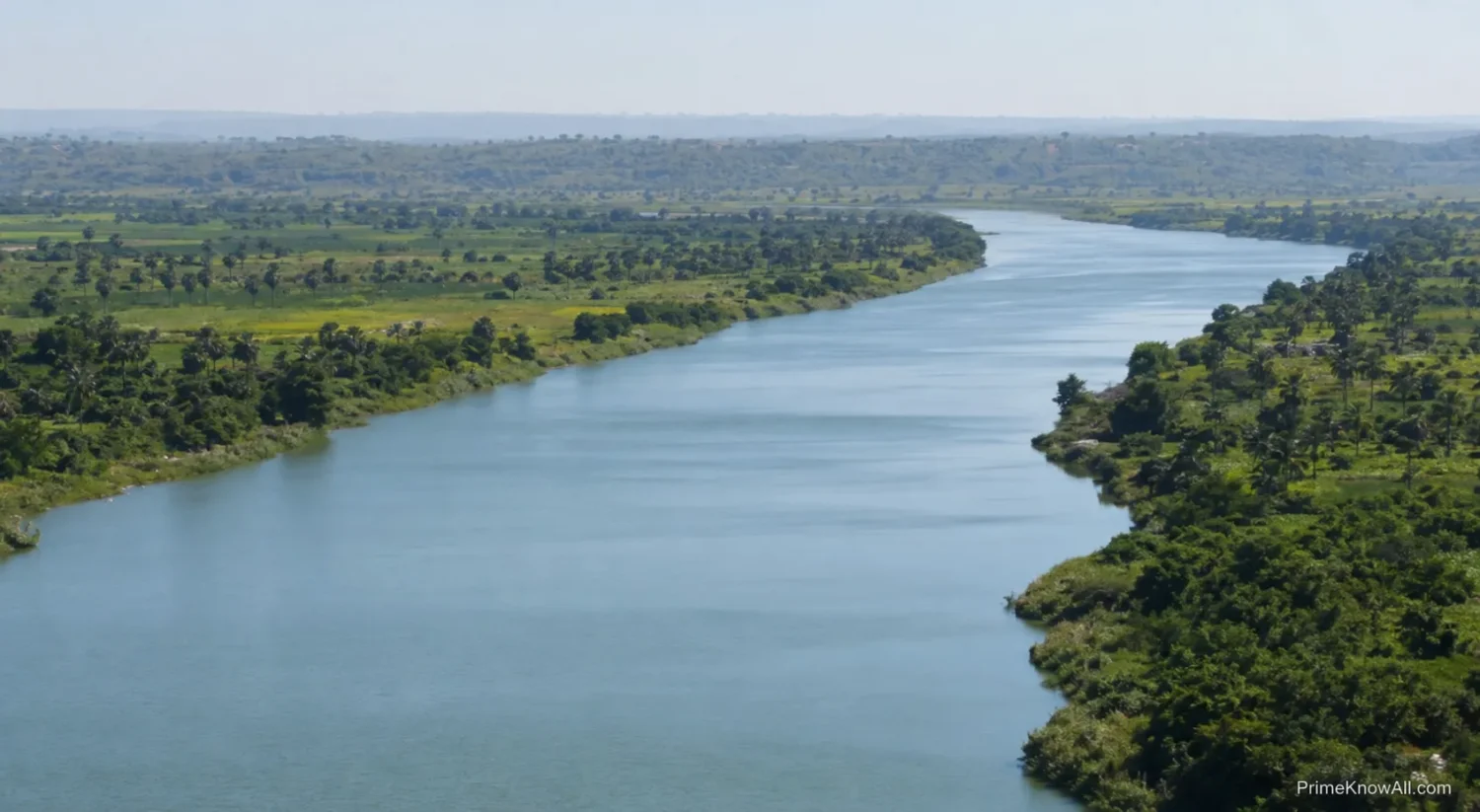
- Source issue: the Apurímac, Apacheta, Carhuasanta, and Mantaro headwater discussions show why the number can move.
- Mouth issue: the Amazon has several Atlantic outlets around the Marajó Island region.
- Scale: the basin covers several million square kilometers and drives one of Earth’s largest freshwater flows into the ocean.
Yangtze River
The Yangtze is Asia’s longest river at about 6,300 km. It rises on the Tibetan Plateau, crosses China from west to east, and reaches the East China Sea near Shanghai.
- Source area: high-elevation headwaters in Qinghai and the broader Tanggula region.
- Mouth: a major delta and estuary zone near Shanghai.
- Human use: shipping, farming, cities, flood control, and hydropower all depend on this river system.
Mississippi–Missouri–Red Rock System
The Mississippi River alone is much shorter than the full Mississippi–Missouri–Red Rock system. When measured from the farthest headwater chain, the system is commonly listed at about 5,971 km.
- Named source: the Mississippi is often taught as starting at Lake Itasca in Minnesota.
- System source: the longer global ranking follows the Missouri and Red Rock headwater chain.
- Mouth: the Mississippi Delta releases water and sediment into the Gulf of Mexico.
Yenisey–Baikal–Selenga System
The Yenisey system drains north through Siberia into the Kara Sea. In long-system rankings, it can be traced through the Selenga, Lake Baikal, and the Angara.
- Source chain: the Selenga headwaters in Mongolia are often used for the longest route.
- Middle link: Lake Baikal sits inside the route through the Angara–Yenisey system.
- Mouth: the river empties into the Arctic Ocean through the Kara Sea.
Yellow River
The Yellow River, or Huang He, is about 5,464 km long. It begins in the Bayan Har Mountains and flows across northern China to the Bohai Sea.
- Name clue: its color comes from fine sediment, much of it linked with the Loess Plateau.
- Mouth: the lower river reaches the Bohai Sea in eastern China.
- Why it matters: sediment, flood control, irrigation, and channel change shape how the river is managed.
What This Means So Far
- Many famous “rivers” in rankings are really linked river systems.
- The mouth can be just as hard to define as the source.
- A long river can be culturally central without being the largest by water flow.
Ob–Irtysh System
The Ob–Irtysh is one of Siberia’s great north-flowing systems. It drains toward the Gulf of Ob and the Kara Sea, with the Irtysh forming the long upstream branch used in the full-system measurement.
- Source chain: the Irtysh headwaters begin in the Altai region.
- Route: the system crosses large parts of western Siberia.
- Mouth: Arctic drainage through the Gulf of Ob.
Paraná River
The Paraná is South America’s second-longest major river system after the Amazon. It rises through the Grande and Paranaíba source region in Brazil and ends in the Río de la Plata estuary.
- Source area: southeast-central Brazil.
- Mouth: Río de la Plata, where river and estuary geography blend.
- Practical note: hydropower, navigation, farming, and wetlands all depend on its flow.
Congo River
The Congo is about 4,700 km long and is Africa’s second-longest river after the Nile. It rises as the Chambeshi in northeastern Zambia and empties into the Atlantic Ocean.
- Source chain: Chambeshi–Lualaba–Congo is the usual long-system route.
- Mouth: Atlantic coast of west-central Africa.
- Distinct trait: the Congo is known for depth and flow, not only length.
Amur–Argun System
The Amur–Argun system runs through northeast Asia and forms long border stretches between Russia and China. Its water reaches the Sea of Okhotsk region.
- Source chain: the Argun is commonly included in the longer system measurement.
- Route: borderland forests, floodplains, and cold-region ecosystems.
- Mouth: lower Amur outlet toward the Sea of Okhotsk.
Lena River
The Lena flows about 4,400 km through eastern Siberia. It begins in mountains west of Lake Baikal and ends in a broad delta on the Laptev Sea.
- Source area: Baikal mountain region.
- Mouth: Laptev Sea, part of the Arctic Ocean.
- Cold-region note: ice, permafrost, and seasonal thaw shape its flow pattern.
Mekong River
The Mekong starts on the Tibetan Plateau and runs through mainland Southeast Asia before reaching the South China Sea through Vietnam’s delta. Its exact length varies by source, with many modern references placing it in the 4,350–4,900 km range depending on measurement.
- Source area: high plateau headwaters in China.
- Mouth: Mekong Delta, Vietnam.
- Shared river: it connects China, Myanmar, Laos, Thailand, Cambodia, and Vietnam.
Mackenzie–Slave–Peace System
The Mackenzie is Canada’s longest river system when measured through the Finlay, Peace, and Slave chain. It drains north into the Beaufort Sea.
- Source chain: western Canadian mountain headwaters.
- Mouth: Mackenzie Delta on the Arctic coast.
- Context: lakes, boreal forest, tundra, and seasonal ice make the system hard to reduce to one simple line.
Niger River
The Niger is about 4,200 km long and follows a striking crescent-shaped route through West Africa. It begins in the Guinea Highlands and reaches the Gulf of Guinea through the Niger Delta.
- Source area: mountains of Guinea near the Sierra Leone border.
- Mouth: Gulf of Guinea, Atlantic Ocean.
- Route note: its inland bend through Mali is one reason the map shape surprises many readers.
Volga River
The Volga is Europe’s longest river at about 3,530 km. It rises in the Valdai Hills and flows into the Caspian Sea, an inland body of water rather than the open ocean.
- Source area: northwest of Moscow in the Valdai Hills.
- Mouth: Caspian Sea near the Volga Delta.
- Map note: because the Caspian is landlocked, the Volga belongs to an endorheic basin.
Why Sources and Mouths Are Hard To Pin Down
The source and mouth of a long river can be scientific choices, not just map labels. A river’s smallest headwater may be seasonal, hidden under ice, unnamed, or connected through lakes and marshes. Its mouth may split into a fan of channels before reaching the sea.
Source Problems
- Farthest distance: the longest water path from mouth to headwater.
- Highest source: the highest-altitude stream that feeds the river.
- Named source: the point where the river’s common name begins.
- Permanent source: a headwater that flows year-round, which may differ from a wet-season channel.
Mouth Problems
- Delta: a sediment-built outlet area where a river splits into several channels.
- Estuary: a partly enclosed coastal water body where river water mixes with seawater.
- Inland basin: a drainage area that does not naturally reach the open ocean, such as the Volga’s route into the Caspian Sea.
- Changing coastline: sediment, erosion, tides, and sea level can move the practical endpoint.
The Amazon shows this problem clearly. Choosing one northern outlet near Marajó Island gives one result; including a southern route linked with a wider estuary gives another. Neither choice is random, but each follows a different measuring rule.
Careful Comparison Rule
- Do not compare a named river with a whole river system unless the method is clear.
- Do not treat a delta mouth as one fixed point when several outlets exist.
- Use rounded numbers for global rankings because exact decimals can create false certainty.
What Length Does Not Tell You
Length tells only one part of a river’s story. A shorter river can carry more water, drain a larger basin, support more navigation, or move more sediment than a longer one.
Discharge means the volume of water flowing past a point in a given time, often measured in cubic meters per second. By that measure, the Amazon outranks every other river by a wide margin. Older USGS material describes the Amazon as carrying roughly 15 percent of all freshwater discharged by rivers into the oceans, with flow far above the Congo and Mississippi.
- Length: distance from source to mouth along the channel.
- Discharge: how much water moves through the river.
- Drainage basin: the land area where rainfall and runoff feed the river.
- Sediment load: the sand, silt, clay, and organic material carried downstream.
- Seasonality: how flow changes during wet seasons, dry seasons, snowmelt, or monsoon cycles.
Recent satellite work makes this point easier to see. The NASA–CNES SWOT mission has been used to estimate river discharge from space, adding a new layer to river study beyond old-style map length. That does not replace ground gauges, but it helps researchers study remote river reaches where long-term measurements can be sparse.
Read A Long River From Source To Mouth
A ranking makes sense only when the starting point, ending point, and system name are visible.
1. Nile — about 6,650 km
East African headwaters → Mediterranean Sea
2. Amazon–Ucayali–Apurímac — about 6,400 km
Peruvian Andes → Atlantic Ocean; source and mouth choices can shift the number.
3. Yangtze — about 6,300 km
Tibetan Plateau → East China Sea
4. Mississippi–Missouri–Red Rock — about 5,971 km
Rocky Mountain headwater chain → Gulf of Mexico
5. Yenisey–Baikal–Selenga — about 5,540 km
Mongolian headwaters → Lake Baikal route → Kara Sea
Memory Rule: Longest means longest measured path. It does not mean widest, deepest, fastest, or highest flow.
Everyday Situations That Make The Ranking Clearer
River-length rules become easier when they are tied to familiar map-reading moments. These examples show how the same river can look different depending on the question being asked.
- A student checks the Mississippi on a school map. The map says Lake Itasca is the source, which is correct for the named Mississippi, but not for the longest Mississippi–Missouri system.
- A traveler follows the Nile north through Egypt. The visible river feels like one line, yet the measured system reaches far upstream through lakes and tributaries in East Africa.
- A reader sees two Amazon rankings online. One list uses the Apurímac route and a northern Atlantic outlet; another uses a different source or mouth, so the numbers do not match.
- A shipping article discusses the Yangtze near Shanghai. The mouth matters there because the delta and estuary connect river traffic with ocean trade.
- A climate story mentions the Mekong Delta. The mouth is not one neat dot; it is a low-lying network where river water, tides, sediment, and human land use meet.
- A map app traces the Volga into the Caspian Sea. The river ends in an inland sea, which shows that not every long river reaches the open ocean.
- A science video compares the Nile and Amazon. The Nile may win many length tables, while the Amazon wins the water-volume comparison by a large margin.
Common Misconceptions
Most confusion comes from mixing length, flow, and river names. The fixes are simple once the measurement rule is visible.
| Misconception | Better Reading | Why It Happens |
|---|---|---|
| The longest river is always the one with the most water. | Length and discharge are different measurements. | The Amazon’s huge flow makes people expect it to top every category. |
| The Mississippi is only about 3,766 km, so it cannot be fourth globally. | The named Mississippi is shorter; the Mississippi–Missouri–Red Rock system is much longer. | School maps often teach named rivers, while global rankings use river systems. |
| A river has one obvious source. | Large rivers can have several candidate headwaters. | Small streams, lakes, and tributary chains can all feed the final river. |
| A river mouth is always a single point. | Deltas and estuaries can spread a mouth across many channels. | Maps simplify wide coastal systems into one label. |
| Exact river lengths never change. | Lengths can shift with mapping methods, channel changes, and endpoint choices. | Rounded reference numbers look more final than the real geography allows. |
Cleaner Way To Say It
- Say “commonly listed as” when naming the longest river.
- Say “river system” when tributaries are part of the measurement.
- Say “about” before global river lengths unless a source gives a survey-specific method.
Quick Test
Use these short checks to test whether the river-length idea is clear. Open each answer and look for the measurement rule.
The Amazon carries more water than the Nile, so it must always be longer.
Not necessarily. Water volume and length are separate measurements. The Amazon leads by discharge, while the Nile is commonly listed first by length in many reference tables.
The Mississippi starts at Lake Itasca, so the global ranking should use only that distance.
That is correct for the named Mississippi River. The longer global entry uses the Mississippi–Missouri–Red Rock river system, which follows the farthest connected headwater chain.
A river mouth is easy to mark because rivers end where the ocean begins.
Not always. A delta or estuary can have several channels, tidal zones, and mixing areas. The Amazon and Paraná both show why the endpoint needs a clear rule.
The Yangtze is the longest river in Asia.
Yes, in standard reference lists the Yangtze is Asia’s longest river, with a length near 6,300 km, running from the Tibetan Plateau to the East China Sea.
The Volga is long, but it does not flow to an ocean.
Correct. The Volga flows into the Caspian Sea, a landlocked water body. This makes it part of an inland drainage basin.
Limits Of River-Length Numbers
River-length rankings are useful, but they are not perfect measurements. The biggest uncertainty comes from headwater choice, delta endpoints, map scale, and natural channel movement.
- Source uncertainty: the farthest tributary can be hard to identify in mountains, wetlands, glacier zones, or seasonal headwaters.
- Mouth uncertainty: wide deltas and estuaries can add or subtract distance depending on the chosen outlet.
- Channel change: rivers migrate, meanders cut off, and sediment can build new land at a delta.
- Data differences: older reference books, national surveys, satellite maps, and academic studies may use different rules.
- Political labels: a familiar river name may not match the longest hydrologic route.
There is also a broader limit: length is not the same as ecological or social value. A shorter river may be more important for a region’s drinking water, farming, fish habitat, flood risk, or transport network. That is why modern river study often combines length with flow, basin area, seasonal change, sediment, water quality, and satellite observation.
What To Remember
The Nile is commonly ranked as the longest river, the Amazon is close enough for measurement debates to matter, and the Yangtze is the longest river wholly within one country’s main territory. The safest way to read any ranking is to check whether it lists the source, mouth, and river system.
The most common mistake is comparing a named river with a longest-path river system. The rule worth keeping: no source, no mouth, no fair comparison.
Sources
The sources below were chosen because they provide reference lengths, river definitions, source-to-mouth geography, or current river-measurement context. Official and institutional sources are preferred where available; reference sources are included where they give clear river tables or edited geographic summaries.
- U.S. Geological Survey – Rivers of the World: World’s Longest Rivers — Useful for rounded river-length figures and for explaining why river length depends on source choice, map precision, and measurement decisions.
- Encyclopaedia Britannica – World’s Longest Rivers — Edited reference table for the main global ranking and standard kilometer/mile figures.
- National Geographic Education – Nile River — Clear educational reference for the Nile’s course, basin context, tributaries, and Mediterranean mouth.
- Encyclopaedia Britannica – Amazon River — Helpful for the Amazon’s length debate, Andean source discussion, Atlantic outlets, basin scale, and discharge context.
- U.S. Geological Survey – The Amazon, Measuring a Mighty River — Strong hydrology source for Amazon discharge comparisons and why flow is a different category from length.
- NASA – NASA-French SWOT Satellite Provides Global Estimate of River Discharge — Current official context for satellite-based river discharge measurement beyond traditional length tables.
- Encyclopaedia Britannica – Yangtze River — Edited reference for Yangtze length, Tibetan Plateau source region, basin scale, and East China Sea mouth.
- Encyclopaedia Britannica – Yellow River — Edited source for Huang He length, Bayan Har Mountains source, Bohai Sea mouth, and sediment-related identity.
- Encyclopaedia Britannica – Congo River — Edited reference for the Congo’s Chambeshi source, length, drainage basin, and Atlantic mouth.
- Mekong River Commission – Geography — Regional institutional source for Mekong length, basin area, source region, route, and delta-to-sea outlet.
FAQ
What is the longest river in the world?
The Nile is commonly listed as the longest river in the world at about 6,650 km. Some Amazon measurements challenge this, but many standard references still place the Nile first.
Is the Amazon longer than the Nile?
It depends on the measuring rule. Some studies that use a different Amazon source and mouth make the Amazon longer, while many reference lists keep the Nile first and the Amazon second.
Why do river length numbers vary?
River lengths vary because sources, tributary chains, deltas, estuaries, map scale, and channel movement all affect the measured path. Rounded numbers are more honest than false precision.
What is the longest river in Asia?
The Yangtze River is usually listed as Asia’s longest river, at about 6,300 km, flowing from the Tibetan Plateau to the East China Sea.
What is the longest river in North America?
The Mississippi–Missouri–Red Rock system is commonly treated as the longest river system in North America in global rankings, at about 5,971 km.
What is the difference between a river and a river system?
A river is the named main channel. A river system includes the main channel plus tributaries used to measure the farthest connected water path.
Which river carries the most water?
The Amazon River carries the most water by discharge. That is a different measurement from length, so the longest river and the largest river by flow do not have to be the same.
Do all long rivers flow into the ocean?
No. The Volga, Europe’s longest river, flows into the Caspian Sea, which is landlocked. Rivers can end in oceans, seas, lakes, inland basins, or other rivers.