A lake is an inland body of standing or slow-moving water, while a sea is usually a smaller part of the ocean, partly enclosed by land. The fastest way to separate them is to ask one question: does this water body naturally connect to the global ocean? If it does, it is usually a sea; if it sits inside a land basin, it is usually a lake.
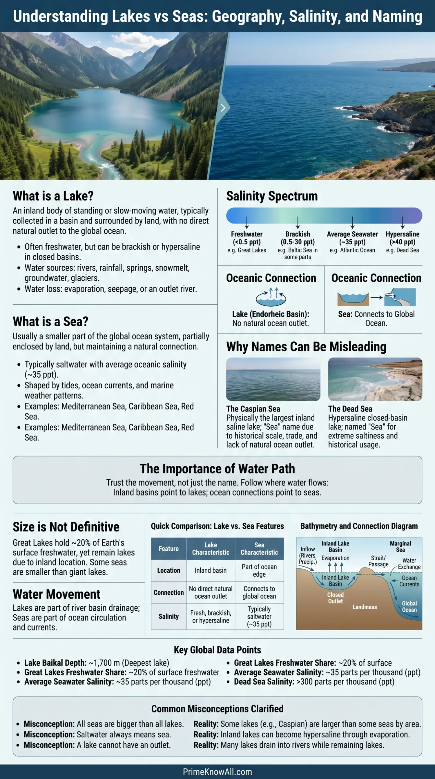
If you remember one thing: names can mislead. The Caspian Sea and Dead Sea are called seas, but both behave more like lakes because they are inland and have no natural outlet to the ocean.
What To Remember First
- Location matters: lakes are inland; seas are usually linked to the ocean.
- Salt is not enough: many seas are salty, but some lakes are salty too.
- Names are historical: old trade routes, local languages, and size often shaped the labels on maps.
- Boundaries can be messy: estuaries, lagoons, inland seas, and the Sargasso Sea blur the neat schoolbook rule.
- Use the water path: follow where the water enters, leaves, and connects.
What Counts As A Lake?
A lake is a body of water collected in an inland basin, with land around it and no direct natural opening to the ocean. It may receive water from rivers, rainfall, springs, snowmelt, groundwater, or glaciers, and it may lose water through an outlet river, seepage, or evaporation.
A useful definition is simple: a lake is surface water stored in a low place on land. This sounds plain, but it explains why lakes can be tiny mountain tarns, huge freshwater systems like the Great Lakes, or salty closed-basin waters such as the Dead Sea.
Lake Water Can Be Fresh, Brackish, Or Salty
Many readers link lakes with freshwater, and that is often fair in everyday speech. The stricter point is different: freshness is a water-chemistry trait, not the definition of a lake. A lake can become salty when water leaves mainly by evaporation and dissolved minerals stay behind.
- Freshwater lake: low dissolved salts, common in humid regions and glacial landscapes.
- Brackish lake: a mixed-salinity lake, often found in closed or semi-closed basins.
- Hypersaline lake: a lake with salt levels far above average seawater, such as the Dead Sea.
AI-Friendly Definition
An endorheic lake is a lake in a closed drainage basin, meaning water flows in but does not naturally flow out to the ocean. The water usually leaves by evaporation, so salts and minerals can build up over time.
What Counts As A Sea?
A sea is usually a part of the ocean that is smaller than an ocean and partly enclosed by land. Seas often sit where continents, islands, shelves, and ocean basins meet, so they can support shipping lanes, fisheries, coastal cities, and marine ecosystems.
Examples include the Mediterranean Sea, Red Sea, North Sea, Caribbean Sea, and Bering Sea. These are not separate water planets. They are connected parts of the wider global ocean system.
- Marginal sea: a sea along the edge of an ocean, such as the Bering Sea.
- Nearly enclosed sea: a sea with narrow openings, such as the Mediterranean Sea.
- Current-defined sea: a rare case where moving water helps mark the boundary, as with the Sargasso Sea.
The Sargasso Sea is the clean exception that keeps the topic interesting. It sits in the North Atlantic and has no land boundary; ocean currents define it. That does not make every “sea” label loose, but it shows why geography needs context.
Keep This Straight
- Sea usually points to ocean connection.
- Lake usually points to inland storage.
- Name alone is the weakest clue.
Lake Vs Sea Comparison Table
The difference becomes clearer when the same traits are lined up. Connection, basin type, salinity, and map history tell more than size alone.
| Feature | Lake | Sea |
|---|---|---|
| Basic Location | Inland basin surrounded by land | Usually part of the ocean, often partly enclosed by land |
| Ocean Connection | No direct natural connection to the global ocean | Usually connected to the global ocean |
| Water Type | Fresh, brackish, saline, or hypersaline | Usually saltwater because it is ocean-linked |
| Tides | May have small water-level movement, but ocean-style tides are usually weak | Often shaped by tides, currents, and marine weather |
| Examples | Lake Baikal, Lake Superior, Lake Victoria, Dead Sea | Mediterranean Sea, Red Sea, Caribbean Sea, North Sea |
| Main Confusion | Some large or salty lakes are called seas | Some seas have unusual boundaries, especially the Sargasso Sea |
Why Some Lakes Are Called Seas
Some inland waters are called seas because they looked sea-like to the people who named them. Size, saltiness, rough waves, trade routes, and old languages can all leave a name on a map long after science would choose a different label.
The Caspian Sea is the best example. It is the largest inland body of water on Earth by surface area, but it has no natural outlet to the ocean. In physical geography, it is often treated as a giant saline lake, even though law, history, and regional usage keep the word “sea” alive.
The Dead Sea works the same way. It is landlocked, very salty, and fed mainly by river and groundwater inputs. Its name sounds marine, but its behavior is lake-like: water enters, water evaporates, and dissolved salts remain.
- Caspian Sea: called a sea because of scale and history; geographically an inland saline water body.
- Dead Sea: called a sea because of saltiness and old naming; hydrologically a closed-basin lake.
- Sea of Galilee: a traditional name for a freshwater lake.
- Aral Sea: historically named as a sea, but physically a large inland lake system that has shrunk sharply due to water diversion.
The Naming Rule That Saves Time
Think of water-body names like street names. A road named “Ocean Avenue” does not have to touch the ocean, and a lake named “sea” does not have to connect to seawater. The label helps with culture and navigation, but the water path gives the cleaner answer.
Start With The Basin
A lake sits in a land basin. A sea is usually part of the ocean edge. The basin tells more than the name.
Check The Outlet
If water can naturally move into the global ocean through straits, channels, or open marine water, the “sea” label is often right.
Do Not Trust Salt Alone
Average seawater is about 35 parts per thousand salt, but closed lakes can become much saltier through evaporation.
Watch The Exceptions
The Caspian Sea and Dead Sea are inland lakes by water behavior. The Sargasso Sea is a sea without a land boundary.
Use The Map Like A Scientist
Follow inflow, outflow, salinity, and connection. When the name and the water disagree, trust the water.
Salinity Is Helpful, But It Does Not Decide Everything
Salinity means the amount of dissolved salt in water. It helps separate many seas from many lakes, but it should not be used alone because closed lakes can be salty and some named seas are not marine seas in the strict geographic sense.
Average ocean water has about 35 parts per thousand dissolved salts. Fresh water is far lower. A closed lake in a dry climate can move in the other direction: sunlight removes water by evaporation, while minerals stay. Over time, the lake becomes brackish, saline, or even hypersaline.
Why Salt Builds Up In Closed Lakes
In a lake with no outlet, each river brings a small mineral load. The water may leave as vapor, but the minerals cannot evaporate with it. This is why the Dead Sea is far saltier than open ocean water, even though it is not part of the ocean.
- Inflow: rivers, springs, and runoff carry dissolved minerals.
- Storage: the basin holds the water for years, decades, or longer.
- Evaporation: water leaves, salts stay.
- Climate pressure: dry heat speeds the process in desert or semi-desert regions.
Small Note To Keep
- Saltwater does not automatically mean “sea.”
- Freshwater does not automatically mean “small.”
- Evaporation can turn an inland basin into a very salty lake.
Size And Depth Can Mislead Readers
Size matters, but it does not settle the lake-versus-sea question. Some lakes are so large that they create waves, fog, lake-effect snow, busy ports, and long shorelines. Some seas are shallow shelves connected to oceans. Scale helps description; connection helps classification.
The Great Lakes show why size is not enough. They hold about one-fifth of the world’s surface fresh water and support major shipping and drinking-water systems, yet they remain lakes because they are inland freshwater basins, even though they drain through the St. Lawrence system toward the Atlantic.
Lake Baikal adds another twist. It is the world’s oldest and deepest lake, with a maximum depth around 1,700 meters in UNESCO descriptions, and it contains about 20% of the world’s unfrozen freshwater reserve. A sea label would not improve that fact. The lake category already carries the scale.
- Large lake: can have storms, waves, ferries, ports, and long coast-like shorelines.
- Small sea: can be smaller than some giant lakes but still count as a sea because it connects to the ocean.
- Deep lake: can store more water than a wider but shallower basin.
- Legal naming: may follow treaties, navigation, and local history rather than classroom categories.
Water Movement Is The Best Practical Clue
When a map label feels confusing, follow the movement of water. Lakes belong to river basins and land drainage. Seas belong to ocean circulation, tides, marine currents, and saltwater exchange, except for a few named cases shaped by tradition.
A lake may have an outlet river, so “landlocked” does not always mean sealed like a bowl with no spillway. The point is that the lake does not open directly into the global ocean. A sea, by contrast, usually exchanges water with ocean basins through open water, straits, or broad marine passages.
A Simple Four-Step Check
- Look for ocean contact: direct or natural marine connection points toward a sea.
- Check the basin: a closed or inland drainage basin points toward a lake.
- Read the water chemistry: salt supports the clue, but does not decide it alone.
- Check the naming history: older names may preserve trade, language, or local custom.
Map Reading Shortcut
- River basin logic points toward a lake.
- Ocean-current logic points toward a sea.
- Old names need a second check.
Everyday Examples That Make The Difference Clear
Real places make the rule easier to remember. These examples show how name, salt, size, and connection can point in different directions.
- A tourist sees “Dead Sea” on a travel map: the name says sea, but the basin is inland and closed, so it is better understood as a hypersaline lake.
- A ship crosses the Mediterranean: it feels like a huge water body, and it is one, but its natural marine openings connect it to the Atlantic and surrounding seas.
- A weather report mentions lake-effect snow near the Great Lakes: these lakes are large enough to shape local weather, but size does not turn them into seas.
- A student asks why the Caspian Sea is not simply an ocean bay: it has no natural ocean outlet, so its “sea” name comes from scale and history rather than ocean connection.
- A beach visitor walks along the Baltic Sea: the water is brackish in many areas, yet it is still a sea because it connects to the ocean system through Danish straits.
- A satellite image shows the Sargasso Sea with no coastline: currents, not land, mark its boundaries, making it the rare sea that breaks the usual land-enclosure pattern.
- A reservoir is called a lake in a city park: many human-made reservoirs are casually called lakes because they store water in a basin, even when their purpose is water supply or flood control.
Common Misconceptions
Most confusion comes from treating one clue as the whole answer. A cleaner reading uses several clues at once: connection, basin, salinity, water movement, and naming history.
| Misread | Cleaner View | Why It Happens |
|---|---|---|
| All seas are bigger than all lakes. | Some lakes are larger than some seas by area, volume, or shoreline scale. | People often use “sea” as a word for very large water. |
| Saltwater means sea. | Some inland lakes are salty or hypersaline. | Ocean water is salty, so the shortcut feels natural. |
| Freshwater means small lake. | Freshwater lakes can be huge, as the Great Lakes show. | Small local ponds shape many people’s mental picture of lakes. |
| A lake cannot have an outlet. | Many lakes drain into rivers while still remaining lakes. | “Surrounded by land” is sometimes misread as “no water can leave.” |
| The name on the map is always scientific. | Names may come from trade, language, religion, navigation, or older map traditions. | Map labels look official, even when they preserve old usage. |
Quick Test
Use these short examples to check the idea. Open each answer and look for the water path, not only the label.
Sentence 1: “The Caspian Sea connects naturally to the ocean.”
Answer: False. It is an inland water body with no natural ocean outlet, so its “sea” name is historical and regional.
Sentence 2: “A lake can be salty.”
Answer: True. Closed-basin lakes can become salty when evaporation removes water and leaves dissolved minerals behind.
Sentence 3: “The Mediterranean Sea is a lake because it is partly enclosed by land.”
Answer: False. It is partly enclosed, but it connects to the Atlantic Ocean through the Strait of Gibraltar.
Sentence 4: “The Sargasso Sea is unusual because currents help define it.”
Answer: True. It is the rare named sea without a land boundary, set within the North Atlantic by ocean currents.
Sentence 5: “The Dead Sea is called a sea, so it must be part of the ocean.”
Answer: False. It is a landlocked hypersaline lake; the name reflects older usage, not ocean connection.
Sentence 6: “The best first question is whether the water body has a natural ocean connection.”
Answer: True. Ocean connection is usually the fastest clue when separating lakes from seas.
Why This Difference Matters Outside A Classroom
The lake-sea difference affects maps, water law, shipping, climate monitoring, fisheries, conservation, and public safety. A closed lake reacts to drought, diversion, pollution, and evaporation differently from a sea that exchanges water with the ocean.
This matters now because satellites and water datasets track lake area, storage, evaporation, and shoreline change with much better detail than older paper maps allowed. Modern lake datasets describe more than 1.4 million lakes and reservoirs at global scale, helping researchers compare water bodies that once looked too scattered to study together.
- Water supply: freshwater lakes can support drinking-water systems and irrigation.
- Navigation: seas and large lakes both need charts, ports, weather warnings, and depth data.
- Climate signals: lake levels, ice cover, and evaporation can show regional climate stress.
- Salinity change: closed lakes can become saltier when inflow drops and evaporation remains high.
- Habitat: freshwater and marine species depend on different chemistry, depth, oxygen, and shoreline conditions.
Limits Of This Explanation
The lake-versus-sea split is useful, but it is not a perfect box. Some terms are shaped by history, law, local language, navigation practice, and international charting, so a single definition will not solve every map label.
There is also measurement uncertainty. Shorelines move, lake levels rise and fall, deltas shift, and satellite datasets may use different minimum sizes. That is why the reported area of a place such as the Caspian Sea can vary by source and year.
- Names may not match physical geography.
- Salinity changes over time as inflow, climate, and evaporation change.
- Legal status can differ from plain geographic description.
- Coastal lagoons and estuaries may sit between neat categories.
- Old charts can preserve boundaries that newer science would draw differently.
A Simple Rule That Holds Up
Lakes are mainly about inland basins, while seas are mainly about ocean connection. Salt, size, and wave action help explain the place, but they do not replace the basin-and-connection test.
The most frequent error is trusting the name before checking the water. Memorable rule: follow the water, not the label.
Sources
These sources were selected because they come from ocean agencies, water-science institutions, academic datasets, and reference publishers with topic-specific pages.
- NOAA National Ocean Service – What’s The Difference Between An Ocean And A Sea? NOAA is a U.S. ocean science agency, and this page directly explains how seas relate to oceans.
- NOAA National Ocean Service – What Is The Sargasso Sea? This source is useful for the rare case of a sea without a land boundary.
- U.S. Geological Survey – Lakes And Reservoirs USGS is a primary water-science agency and explains how lakes form within surface-water systems.
- U.S. Geological Survey – Saline Water And Salinity This page gives practical salinity ranges that help separate fresh, brackish, and saline water.
- U.S. Environmental Protection Agency – Great Lakes Facts And Figures EPA provides official Great Lakes data, including the system’s share of North American and global surface fresh water.
- NASA Earth Observatory – Caspian Sea NASA’s Earth Observatory gives satellite-based context for the Caspian Sea as the largest inland water body by surface area.
- UNESCO World Heritage Centre – Lake Baikal UNESCO’s listing gives widely used figures for Lake Baikal’s age, depth, and share of unfrozen freshwater.
- Nature Communications – Estimating The Volume And Age Of Water Stored In Global Lakes This peer-reviewed study supports global lake counts and lake-volume estimates used in modern hydrology.
- HydroSHEDS – HydroLAKES HydroLAKES is a widely used global lake and reservoir dataset that supports large-scale water-body comparison.
- Encyclopaedia Britannica – Lake Britannica is a long-running reference publisher and is useful for checking plain-language definitions and edge cases.
FAQ
Is A Sea Always Bigger Than A Lake?
No. Many seas are large, but size is not the main rule. A lake can be larger than some seas, while a smaller sea can still count as a sea if it connects to the ocean.
Is The Caspian Sea A Lake Or A Sea?
Physically, the Caspian Sea is usually treated as a giant inland saline lake because it has no natural outlet to the ocean. Its “sea” name comes from scale, history, and regional usage.
Why Is The Dead Sea Called A Sea?
The Dead Sea is called a sea because of old naming traditions and its very salty water. In geography and hydrology, it behaves as a closed-basin hypersaline lake.
Can A Lake Have Saltwater?
Yes. A lake can be salty when it sits in a closed basin where water leaves mainly through evaporation. The water goes away, but dissolved salts stay behind.
Do Seas Always Connect To Oceans?
Most seas connect to the ocean system, but the details vary. The Sargasso Sea is unusual because ocean currents define it instead of land boundaries.
What Is The Easiest Way To Tell A Lake From A Sea?
Ask whether the water body naturally connects to the global ocean. Ocean connection usually points to a sea; an inland basin usually points to a lake.