
A jet stream is a narrow band of very fast wind high in the atmosphere, usually close to the tropopause. These winds mainly flow from west to east, although their paths bend north and south. Their position and strength help steer storm systems, separate air masses, change temperature patterns, and even affect how long an aircraft spends crossing an ocean.
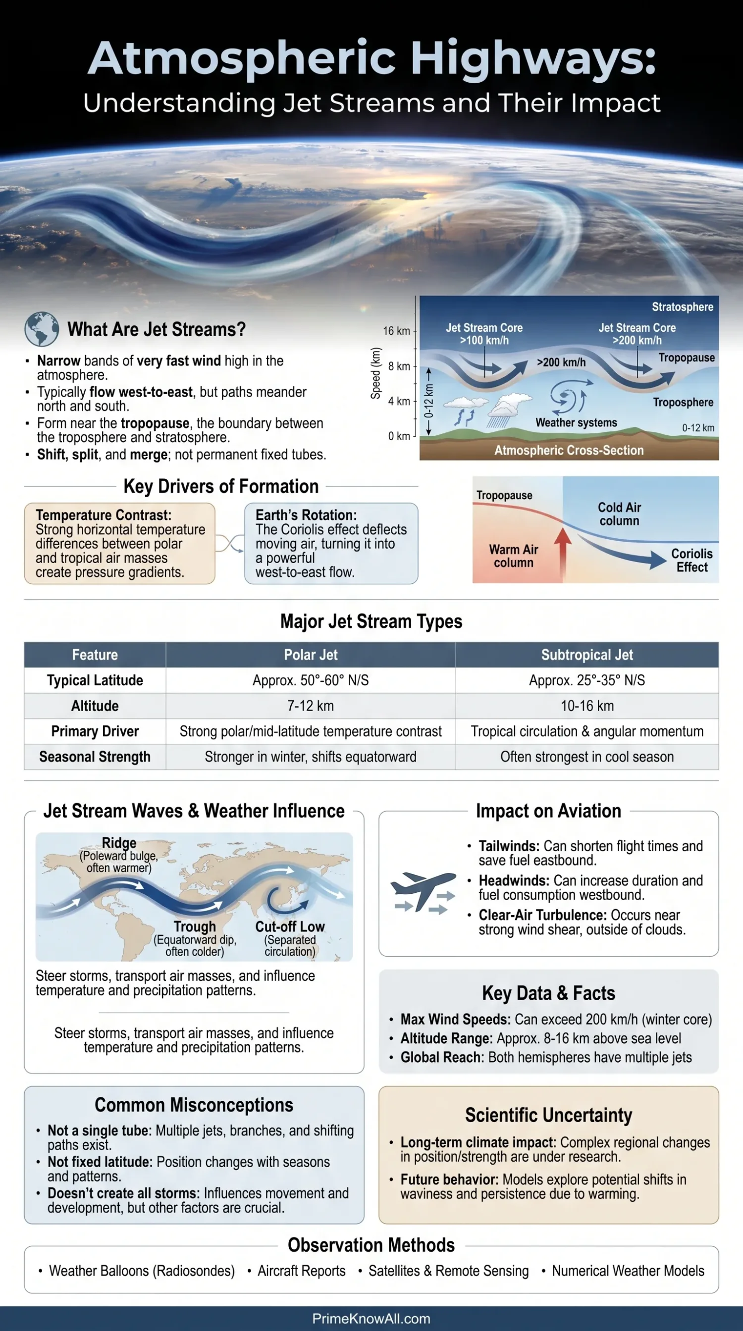
Jet streams are not single permanent tubes of air. They shift, split, merge, weaken, and strengthen as temperature contrasts and large-scale pressure patterns change. A weather map of the upper atmosphere can therefore look very different from one week to the next.
- The main jet streams form near the upper troposphere and tropopause.
- The strongest sections can reach well above 200 km/h, especially during winter.
- Earth normally has several jet streams, including polar and subtropical jets in both hemispheres.
- Their curves help determine where storms, cold outbreaks, warm spells, and bands of heavy precipitation are most likely to travel.
What Is a Jet Stream?
A jet stream is a fast-moving current of upper-level air that is much longer than it is wide or deep. Meteorologists usually identify it by studying wind speed and direction on upper-air charts rather than by looking for a visible feature in the sky.
Most major jet streams lie roughly 8 to 15 kilometers above sea level, though their exact altitude changes with latitude, season, and atmospheric conditions. This places them near the boundary between the troposphere, where most weather occurs, and the more stable stratosphere above it.
The word stream can be slightly misleading. A jet stream is not surrounded by still air like a river running through dry land. Instead, it is a zone where upper-level winds become much faster than the air to either side.
Jet streaks are especially fast sections embedded within a jet stream. Their entrance and exit regions can alter rising and sinking motion in the atmosphere, so forecasters watch them closely when evaluating developing low-pressure systems and precipitation.
Why Jet Streams Form Near the Tropopause
Jet streams form because the atmosphere contains large horizontal temperature differences and because Earth rotates. The strongest upper-level winds tend to develop where warm and cold air masses meet across relatively short distances.
Temperature Differences Create Pressure Differences Aloft
Warm air columns expand more than cold air columns. As altitude increases, this creates differences in atmospheric pressure between warmer and colder regions. The resulting pressure-gradient force accelerates air from higher pressure toward lower pressure.
The contrast is especially pronounced near major boundaries between tropical, mid-latitude, and polar air. Stronger temperature gradients are therefore associated with stronger changes in wind speed with altitude, a relationship meteorologists describe through the thermal wind concept.
Earth’s Rotation Turns the Flow
If Earth did not rotate, air driven by pressure differences would move much more directly from one region toward another. Rotation introduces the Coriolis effect, which deflects large-scale moving air to the right in the Northern Hemisphere and to the left in the Southern Hemisphere.
High in the atmosphere, where friction from the surface is weak, the pressure-gradient force and rotational effects can come close to balancing one another. The wind then flows mostly along pressure contours rather than straight across them. This helps produce the strong west-to-east winds associated with the major jets.
A useful analogy is a moving walkway that bends rather than runs in a straight corridor. The walkway provides a fast preferred route, while its curves determine where travelers are carried. A jet stream behaves similarly for large weather systems: it does not create every storm, but its changing path strongly influences where many mid-latitude systems move.
Polar and Subtropical Jet Streams
The atmosphere can contain several jet streams at the same time. The two best-known families are the polar-front jet and the subtropical jet. Both exist in the Northern and Southern Hemispheres, although their exact paths constantly change.
| Feature | Polar Jet | Subtropical Jet |
|---|---|---|
| Typical Latitude Zone | Often around 50°–60° north or south | Often around 25°–35° north or south |
| Approximate Altitude | About 7–12 km | About 10–16 km |
| Main Atmospheric Link | Strong temperature contrast between polar and mid-latitude air | Upper-level flow associated partly with tropical circulation and angular momentum |
| Seasonal Tendency | Commonly stronger and farther equatorward in winter | Often strongest during the cool season of each hemisphere |
| Weather Influence | Closely associated with many mid-latitude storm tracks | Can affect subtropical storm development, moisture transport, and upper-level winds |
These latitude bands should not be read as fixed borders. A polar jet can dip far toward the equator in one region while arching toward the pole somewhere else. It can also split into separate branches.
Why Jet Streams Bend Into Large Waves
Jet streams rarely circle Earth as perfectly straight west-to-east bands. Their paths develop broad ridges and troughs related to Rossby waves, planetary-scale motions produced by atmospheric dynamics on a rotating sphere.
Ridges and Troughs
A ridge is a poleward bulge in the upper-level flow, while a trough is an equatorward dip. In the Northern Hemisphere, ridges are often associated with warmer conditions beneath or downstream of them, while troughs can help transport colder air toward lower latitudes. The exact surface outcome still depends on moisture, pressure systems, terrain, and the position of nearby fronts.
These waves can travel along the jet or become slow-moving. When a large-scale pattern moves slowly, the weather underneath it may also persist longer than usual.
The Jet Can Split or Form Cut-Off Systems
Sometimes the upper-level flow separates into northern and southern branches. Large troughs can also pinch off, leaving an upper-level low separated from the main current. These cut-off lows may move slowly because they are no longer being carried steadily by the strongest part of the jet.
- Fast, relatively straight flow can move weather systems across a region rapidly.
- Deep waves can carry unusually warm or cold air far from its usual latitude.
- Slow or blocked patterns can allow similar weather to persist for several days.
How Jet Streams Shape Weather
Jet streams influence weather by steering large-scale atmospheric systems and interacting with areas of rising and sinking air. They are especially important for weather in the middle latitudes, where warm and cold air masses frequently meet.
Storm Tracks
Many extratropical low-pressure systems move broadly along paths related to the upper-level flow. A change in the jet stream can therefore shift a storm track hundreds of kilometers north or south over time.
This does not mean a storm simply sits inside the jet like an object on a conveyor belt. Surface cyclones interact with temperature contrasts, moisture, upper-level divergence, fronts, and their own developing circulation. The jet is one part of that larger system.
Cold and Warm Air Transport
When the polar jet develops a deep equatorward trough, cold air can spread toward lower latitudes behind advancing fronts. A strong ridge can support the opposite arrangement, with warmer air extending farther poleward.
For this reason, a map of upper-level winds often explains why neighboring regions experience sharply different temperatures at the same time.
Rain and Snow Patterns
The jet stream does not contain rain or snow by itself. Its importance comes from how upper-level winds affect the movement and development of weather systems. When suitable moisture and temperature conditions are present, these systems can produce rain, snow, thunderstorms, or mixed precipitation.
A storm following a more northerly path may leave one area mild and wet while another remains cold and dry. A southward shift can reverse that pattern.
Rapid Storm Development
Certain regions near powerful jet streaks favor divergence in the upper atmosphere. When air is removed from a column aloft, surface pressure can fall if other conditions also support development. This is one reason upper-air wind maps are studied when meteorologists assess rapidly strengthening mid-latitude cyclones.
Where the Jet Stream Sits in the Atmosphere
From the surface to the lower stratosphere
Stable air above the tropopause. The highest subtropical jet levels may approach this boundary region.
Major jet streams are concentrated near this transition because upper-level temperature and pressure gradients favor very strong winds.
Polar and subtropical jets can contain wind speeds above 200 km/h, with stronger cores possible during favorable winter patterns.
Fronts, clouds, precipitation, and low-pressure systems interact with the circulation guided by upper-level winds.
People experience the resulting changes as shifting temperatures, wind, rain, snow, storm tracks, and periods of calmer weather.
Why Jet Streams Are Often Stronger in Winter
The polar jet is commonly stronger during winter because the temperature difference between polar and lower-latitude air tends to become larger. A stronger horizontal temperature gradient can support stronger upper-level winds.
The jet also tends to shift toward lower latitudes during the cool season and retreat poleward during the warm season. Local patterns can depart from this broad seasonal behavior, and the Northern and Southern Hemispheres experience opposite seasons.
Wind speeds inside powerful winter jet streaks can exceed 200 km/h, and stronger values are possible. The exact maximum depends on the atmospheric setup, location, altitude, and the method used to define the jet’s core.
What Jet Streams Mean for Aviation
Jet streams matter to aviation because high-altitude aircraft operate near the same part of the atmosphere. Airlines and flight planners can use favorable upper-level winds to reduce travel time and fuel use, while strong opposing winds can lengthen a route.
Tailwinds and Headwinds
An eastbound aircraft over the mid-latitudes may receive a strong tailwind from the prevailing west-to-east upper-level flow. A westbound aircraft can encounter the same winds as a headwind.
This helps explain why two flights between the same cities can have different scheduled or actual flight times depending on direction and the atmospheric pattern that day.
Clear-Air Turbulence
Strong changes in wind speed or direction near a jet stream can contribute to clear-air turbulence. Unlike turbulence inside a thunderstorm, this type may occur in areas without obvious clouds.
The jet itself is not uniformly turbulent. Pilots and forecasters pay particular attention to regions with strong vertical or horizontal wind shear, jet streaks, fronts, and other atmospheric features that can make turbulence more likely.
Where Jet Streams Show Up in Everyday Weather
The jet stream is far above everyday life, yet its position can help explain weather changes visible at ground level. These examples show how upper-air patterns can translate into familiar situations.
- A winter cold front arrives rapidly. A southward dip in the polar jet may help steer a low-pressure system and colder air toward lower latitudes.
- Several storms follow similar routes. A persistent upper-level pattern can repeatedly guide weather systems through the same broad corridor.
- A region stays unusually mild for several days. A ridge can keep the main storm track farther away while allowing warmer air to extend poleward.
- Rain continues because systems move slowly. A weakly progressing or blocked upper-air pattern can reduce the speed at which some weather systems leave an area.
- An eastbound transatlantic flight arrives earlier than expected. Flight planning may take advantage of a strong tailwind associated with the North Atlantic jet.
- A westbound flight takes noticeably longer. Strong upper-level westerlies can act as a headwind even though the distance between airports has not changed.
- Temperatures differ sharply across a continent. A large ridge-trough pattern can transport warm air northward in one sector while allowing cold air to move southward elsewhere.
What Jet Streams Do Not Mean
Several simplified descriptions of jet streams can create the wrong picture. The real atmosphere is more variable than a single wavy line on a television weather map suggests.
- The jet stream is not one continuous wind circling Earth. Several jets and separate branches can exist at once, with gaps and changing wind maxima.
- It is not fixed at one latitude. Its position shifts north and south as planetary-scale waves evolve.
- It does not directly create every storm. Storm development also depends on temperature gradients, moisture, surface pressure, fronts, stability, and other upper-level processes.
- A southward jet does not automatically mean extreme cold. The source region and depth of the air mass matter.
- A northward jet does not guarantee dry weather. Moisture and other circulation features can still produce rain or storms.
- The fastest wind is not always directly above the strongest surface weather. Upper-level and surface features can be displaced from each other.
Jet Streams and a Warming Climate
Researchers study how long-term climate change may alter jet-stream position, strength, seasonality, and waviness. The topic is more complicated than the claim that warming simply makes the jet stream weaker or more distorted everywhere.
Arctic temperatures have risen faster than the global average over recent decades. Because temperature contrasts help shape upper-level winds, scientists have investigated whether this changing contrast can affect Northern Hemisphere circulation. Research has found regional and seasonal changes, but the size, direction, and causes of long-term jet-stream trends can differ among datasets and atmospheric levels.
Other processes also matter. Tropical warming, changes in the stratosphere, sea-surface temperatures, natural climate variability, and shifts in storm tracks can all influence upper-level circulation. For that reason, individual heat waves, cold outbreaks, or floods cannot be attributed to a single jet-stream mechanism merely because the jet was unusually curved during the event.
How Meteorologists Observe and Forecast Jet Streams
Meteorologists do not need to see a jet stream directly. They reconstruct upper-level winds using weather balloons, aircraft observations, satellites, remote-sensing systems, and numerical weather models.
Weather Balloons
Radiosondes carried by balloons measure temperature, humidity, pressure, and wind as they rise through the atmosphere. Measurements from many stations help describe the vertical structure surrounding a jet.
Aircraft Observations
Commercial aircraft provide additional observations along busy flight corridors. These reports are valuable because aircraft often travel close to the altitude of major jet streams.
Satellites and Numerical Models
Satellite observations help describe temperature, moisture, cloud patterns, and atmospheric motion over oceans and sparsely observed regions. Forecast models combine many observations with equations describing atmospheric motion to estimate where the jet will move during the following hours and days.
Upper-air charts commonly display winds on pressure surfaces such as 300 hPa or 250 hPa, levels that are often close to major jet-stream winds. Forecasters can then identify jet streaks, ridges, troughs, and changes in the larger circulation.
Where Forecast Uncertainty Comes From
The broad physics of jet streams is well established, but their exact future path becomes harder to predict as forecast time increases. Small differences in the initial atmospheric state can grow, particularly when strong temperature gradients, developing storms, or large waves are involved.
There is also no single altitude or wind-speed value that describes every jet. The tropopause is lower near the poles and higher in the tropics, while jet position changes with season and day-to-day circulation. Numerical ranges are therefore best treated as typical values rather than fixed boundaries.
Long-term changes are harder to summarize than daily weather patterns. Different jet-stream metrics can measure latitude, speed, waviness, or persistence, and those metrics do not always change in the same direction. Regional results should not automatically be extended to the entire planet.
Jet Stream Questions
How high is the jet stream?
Major jet streams are commonly found roughly 8 to 15 kilometers above sea level, near the upper troposphere and tropopause. The polar jet can be lower than the subtropical jet, and the altitude changes with latitude, season, and weather conditions.
How fast can a jet stream move?
Wind speeds in strong jet-stream cores can exceed 200 km/h, especially in winter. Individual jet streaks can become faster, so there is no single maximum speed that applies to every jet stream.
Does the jet stream move from west to east?
The major mid-latitude jets predominantly contain westerly winds, meaning air moves broadly from west toward east. Their paths can bend sharply north and south, producing large ridges and troughs rather than a straight line.
Can the jet stream cause cold weather?
The jet stream can help transport and steer cold air toward lower latitudes when its pattern supports a deep trough, but the jet alone does not determine surface temperature. The origin and depth of the air mass, cloud cover, terrain, and other weather systems also matter.
Can the jet stream cause storms?
Jet streams can support storm development and steer existing systems, especially where upper-level wind patterns favor rising air. Storms still require other atmospheric ingredients, so the presence of a strong jet does not guarantee severe or wet weather at the surface.
Why do airplanes use the jet stream?
Aircraft traveling in the same direction as a strong jet can receive a large tailwind, reducing flight time and fuel use. Flights traveling against the flow may instead face stronger headwinds, so routes are adjusted according to upper-level wind forecasts.
Sources
- NOAA – The Jet Stream. NOAA provides federal meteorological education material explaining where jet streams form, why they develop, and how they relate to large-scale atmospheric circulation.
- National Weather Service – Jet Streams. The U.S. National Weather Service provides operational meteorology material on upper-level winds, jet streaks, and their connection with weather systems.
- Met Office – What Is the Jet Stream?. The United Kingdom’s national meteorological service explains jet-stream formation, seasonal behavior, and its role in steering weather.
- UCAR Center for Science Education – Jet Stream. UCAR specializes in atmospheric science and provides educational material connecting temperature gradients, atmospheric circulation, and jet-stream behavior.
- American Meteorological Society – Glossary of Meteorology: Jet Stream. The AMS glossary provides terminology used by atmospheric scientists and is useful for checking the formal meteorological meaning of a jet stream.
- Encyclopaedia Britannica – Jet Stream. Britannica offers an independent reference overview of the discovery, structure, location, and behavior of high-altitude jet streams.