
El Niño and La Niña are opposite phases of a natural ocean–atmosphere pattern called the El Niño–Southern Oscillation, or ENSO. El Niño develops when the central and eastern tropical Pacific become unusually warm and the atmosphere responds; La Niña involves unusually cool water in the same broad region together with an opposite atmospheric response.
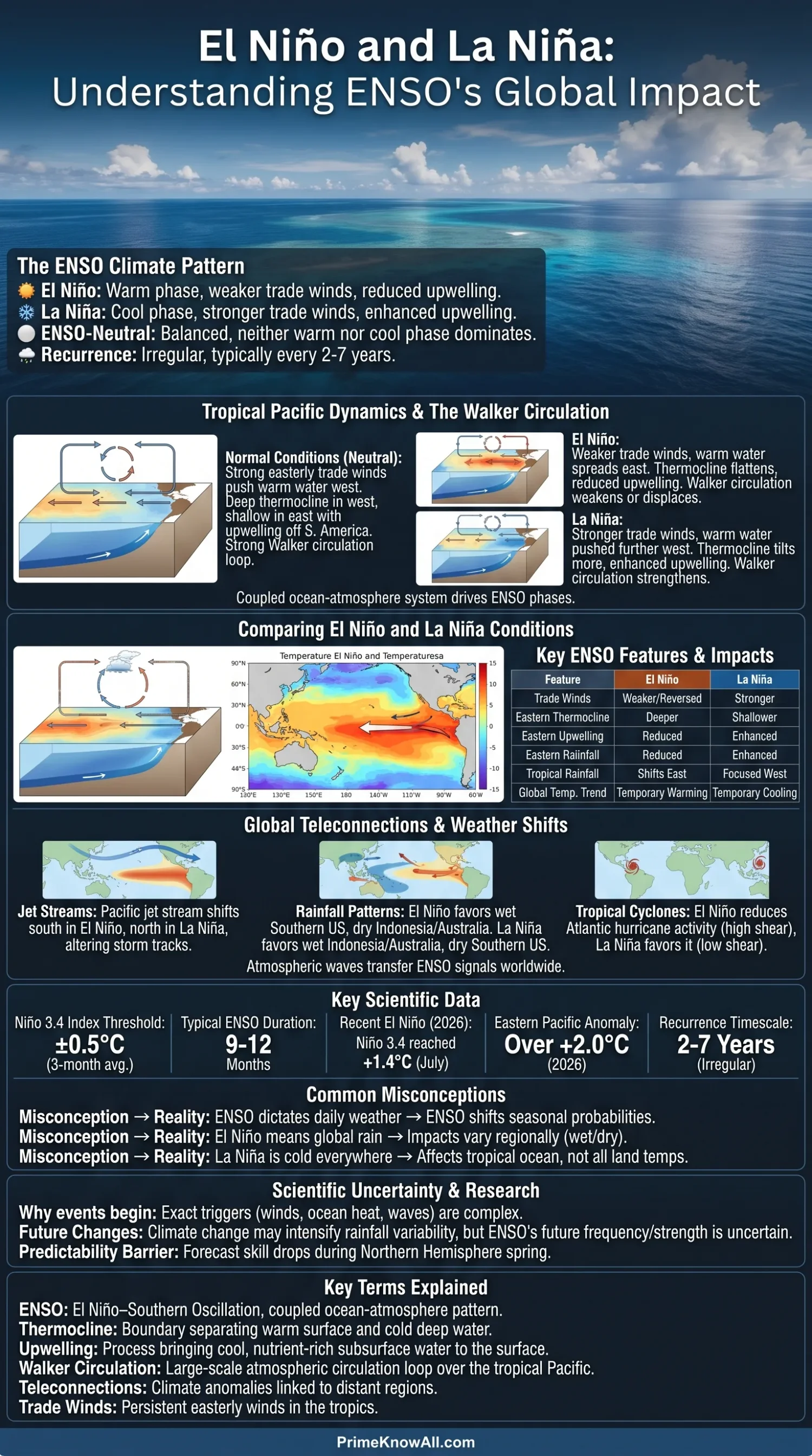
These changes begin thousands of kilometers from many populated regions, yet they can shift rainfall, drought risk, jet streams, tropical cyclone conditions, ocean productivity and seasonal temperatures across much of the planet. ENSO does not dictate the weather on a particular day. It changes the odds of certain seasonal patterns.
- El Niño: weaker tropical Pacific trade winds, warmer central/eastern Pacific water and reduced eastern-Pacific upwelling.
- La Niña: stronger trade winds, cooler central/eastern Pacific water and stronger upwelling.
- ENSO-neutral: neither warm nor cool phase has developed as a coupled ocean–atmosphere event.
- Events recur irregularly, commonly on a two-to-seven-year timescale, rather than following a fixed calendar.
How the Tropical Pacific Works Before ENSO Shifts
To understand El Niño and La Niña, it helps to start with the tropical Pacific in something close to its normal state. Easterly trade winds usually blow from the Americas toward Indonesia and the western Pacific, pushing warm surface water westward.
ENSO-Neutral Conditions
During ENSO-neutral conditions, the western tropical Pacific normally contains a deep pool of very warm water. Near Ecuador and Peru, winds help bring cooler subsurface water toward the surface through upwelling. This eastern water is relatively cool and rich in nutrients.
The boundary separating warm surface water from colder deep water is called the thermocline. Across the equatorial Pacific it normally tilts: deeper in the west and shallower in the east.
Warm western-Pacific water supports rising humid air and frequent thunderstorms. Higher in the atmosphere, air moves eastward before sinking over cooler parts of the Pacific. Near the surface it returns westward with the trade winds. This large circulation loop is known as the Walker circulation.
A useful mental picture is a wide tray of water being pushed steadily toward one end. The trade winds are the push, keeping more warm surface water piled toward the western Pacific. If that push weakens, the distribution of water changes and warmth can spread eastward. If the push becomes stronger, warm water is held farther west while more cool water reaches the surface in the east. The real Pacific is far more complex, with currents and large ocean waves involved, but the comparison captures the basic shift.
El Niño vs. La Niña
The two phases alter the same coupled Pacific system in opposing directions. Ocean temperature alone is not the whole story: winds, pressure and tropical rainfall also need to respond for a mature ENSO event.
| Feature | El Niño | ENSO-Neutral | La Niña |
|---|---|---|---|
| Central/eastern tropical Pacific | Warmer than the relevant average | Near the expected range | Cooler than the relevant average |
| Equatorial trade winds | Usually weaker | Near normal pattern | Usually stronger |
| Eastern-Pacific thermocline | Deeper | Relatively shallow | Shallower |
| Eastern-Pacific upwelling | Reduced | Active | Enhanced |
| Warm-water concentration | Extends farther east | Focused toward western Pacific | Pushed farther west |
| Walker circulation | Usually weakened or displaced | Normal broad circulation | Usually strengthened |
| Tropical rainfall center | Shifts toward central/eastern Pacific | Strong western-Pacific focus | More strongly focused toward western Pacific |
| Typical global surface-temperature influence | Temporary warming tendency | No strong ENSO push | Temporary cooling tendency relative to nearby years |
What Happens During El Niño?
El Niño begins as the usual Pacific balance weakens. Trade winds become weaker than normal and can occasionally reverse over parts of the equatorial Pacific. Warm water spreads eastward, while the thermocline becomes deeper in the eastern Pacific.
With the colder subsurface water pushed farther down, upwelling near the eastern equatorial Pacific becomes less effective. Sea-surface temperatures rise over a broad area. Thunderstorms and rising air that normally favor the western Pacific can shift toward the central or eastern Pacific.
The changed tropical heating pattern then alters atmospheric circulation beyond the Pacific. This is how an ocean temperature anomaly near the equator can eventually influence storm tracks over North America, rainfall in Africa or conditions affecting tropical cyclones.
What Happens During La Niña?
La Niña strengthens much of the usual tropical Pacific pattern. Easterly trade winds become stronger, pushing more warm surface water toward Indonesia and the western Pacific. The eastern-Pacific thermocline becomes shallower and cooler subsurface water reaches the surface more readily.
The central and eastern equatorial Pacific therefore become cooler than the chosen climate average. Tropical convection tends to remain farther west, and the Walker circulation strengthens.
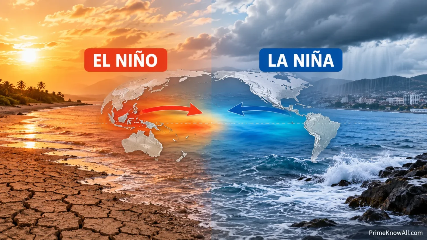
La Niña is sometimes described as El Niño’s mirror image, but that is only an approximation. The two phases can differ in duration, location, strength and atmospheric effects, and individual events do not produce perfectly reversed weather maps.
Why the Ocean and Atmosphere Reinforce Each Other
ENSO persists because the tropical ocean and atmosphere interact rather than changing independently. A shift in Pacific temperature can alter the winds, while a shift in the winds can alter ocean temperature. Scientists often describe this reinforcing interaction as the Bjerknes feedback.
Suppose the eastern and central Pacific start warming. The east–west temperature contrast weakens, which can weaken the trade winds. Weaker winds allow still more warm water to remain or move eastward and reduce cold-water upwelling. That can reinforce El Niño conditions.
La Niña can develop through the opposite tendency. Stronger easterly winds strengthen the ocean’s east–west temperature contrast, increase eastern upwelling and help maintain cooler central/eastern Pacific water.
The feedback cannot continue forever. Subsurface ocean heat, equatorial Kelvin waves, Rossby waves, seasonal changes and atmospheric variability all help control the growth and eventual decay of ENSO events. This is one reason ENSO behaves irregularly instead of oscillating on a perfectly fixed schedule.
How Scientists Measure El Niño and La Niña
Scientists track ENSO with sea-surface temperatures, subsurface temperatures, winds, rainfall and atmospheric pressure. One of the most closely watched areas is the Niño 3.4 region, spanning approximately 5°N–5°S and 170°W–120°W in the equatorial Pacific.
The 0.5°C Threshold
A commonly used historical classification treats a three-month Niño 3.4 temperature index of at least +0.5°C as warm territory and −0.5°C or lower as cool territory. For historical episode lists, NOAA applies the threshold for at least five consecutive overlapping three-month seasons.
Crossing a temperature threshold by itself does not mean every atmospheric feature has immediately become El Niño or La Niña. Operational assessments also examine whether the atmosphere is coupled to the ocean anomaly, including changes in tropical winds and convection.
RONI and ONI Are Not Exactly the Same
Many older articles describe ENSO using NOAA’s Oceanic Niño Index, or ONI. In 2026, NOAA’s Climate Prediction Center moved its official ENSO monitoring and prediction to the Relative Oceanic Niño Index, or RONI.
RONI still starts with Niño 3.4 sea-surface temperature anomalies, but it also subtracts the average tropical sea-surface temperature anomaly between 20°N and 20°S before applying an adjustment to preserve comparable variability. NOAA currently uses a 1991–2020 climate base period for this measure. The change helps distinguish Pacific ENSO variability from broader tropical-ocean warming.
Temperature index ≠ local weather forecast. A high ENSO index can make familiar teleconnection patterns more likely, but it cannot tell whether one city will have a flood, snowstorm, drought or heatwave on a given date.
What the Southern Oscillation Means
The Southern Oscillation is the atmospheric side of ENSO. It describes a broad east–west seesaw in tropical Pacific air pressure that changes together with winds, rainfall and ocean temperature.
One traditional measure is the Southern Oscillation Index, or SOI, which uses pressure differences between Tahiti and Darwin, Australia. Different meteorological agencies can calculate the index somewhat differently, so values from separate datasets should not always be compared as though they were identical.
During El Niño, pressure patterns commonly reflect a weakened Walker circulation. During La Niña, the pressure pattern is generally associated with a stronger Walker circulation. The full name El Niño–Southern Oscillation reflects this coupling between the Pacific Ocean and atmosphere.
How a Pacific Change Reaches Distant Continents
ENSO changes where large areas of tropical thunderstorms release heat into the atmosphere. That altered heating produces atmospheric waves capable of reorganizing circulation far from the equatorial Pacific. These distant connections are called teleconnections.
Jet streams and storm tracks can shift in response. The pattern depends strongly on the season, which is why ENSO’s influence over North America is usually clearer during Northern Hemisphere winter than during summer.
From Pacific Ocean Shift to Seasonal Weather
1. Trade Winds Change
Weaker easterly winds favor El Niño development. Stronger easterly winds favor La Niña conditions.
2. Ocean Heat Is Redistributed
El Niño: warm water extends east and the eastern thermocline deepens.
La Niña: warm water is pushed west and the eastern thermocline becomes shallower.
3. Tropical Rainfall Moves
The main zones of rising air and thunderstorms shift with the warmest water, changing the Walker circulation and tropical atmospheric heating.
4. Jet Streams and Storm Tracks Respond
Atmospheric teleconnections alter the probability of seasonal wet, dry, warm or cool patterns far beyond the Pacific.
5. Local Outcomes Still Vary
ENSO changes climate odds. Local ocean temperatures, soil moisture, other climate patterns and ordinary weather variability can strengthen, weaken or override its usual regional influence.
Typical Weather Patterns Around the World
ENSO produces recognizable regional patterns when many past events are averaged together, but no individual El Niño or La Niña follows the average map exactly. Timing, strength, the location of Pacific warming or cooling and interactions with other ocean patterns all matter.
North America
During many El Niño winters, the Pacific jet stream shifts southward and extends farther east. This tends to favor wetter conditions across parts of the southern United States and milder conditions across portions of the northern United States and Canada.
La Niña winters commonly place the jet stream farther north. Parts of the Pacific Northwest and northern tier can become wetter or cooler, while parts of the southern United States have higher odds of warmer and drier conditions. Local patterns can depart sharply from these averages.
Western South America
El Niño is closely tied to warming in the tropical Pacific near the Americas. In some events, coastal Ecuador and northern Peru experience much wetter conditions and higher flood risk. La Niña favors cooler eastern-Pacific water and can shift rainfall in the opposite direction, though effects vary by location and season.
Australia and Southeast Asia
El Niño often shifts tropical rainfall away from Indonesia and parts of Australia, raising the chance of dry conditions in some seasons. La Niña strengthens the western-Pacific warm pool and is often linked with higher rainfall over parts of Indonesia and Australia.
The relationship is not uniform across either country or region. Local sea temperatures, monsoon circulation and other climate patterns can alter the outcome.
Africa and South Asia
ENSO has several seasonal links across Africa. El Niño can favor wetter October–December short rains in parts of equatorial East Africa, while southern Africa faces higher drought risk during some El Niño seasons. La Niña can shift those probabilities in the opposite direction.
El Niño has also been associated with weaker Indian summer monsoon rainfall in many years, but the connection is not one-to-one. Some El Niño years have avoided major Indian rainfall deficits, showing why ENSO should be used together with regional forecasts rather than as a stand-alone prediction.
How ENSO Affects Hurricanes and Tropical Cyclones
ENSO can alter the vertical wind shear that tropical cyclones experience. Wind shear is the change in wind speed or direction with height, and strong shear can make it harder for a tropical cyclone to organize.
El Niño commonly increases upper-level wind shear over parts of the tropical Atlantic, which tends to suppress Atlantic hurricane activity. La Niña commonly reduces that shear and creates an atmospheric setup more favorable for Atlantic tropical cyclone development.
The Pacific can respond differently. ENSO changes cyclone locations and atmospheric conditions across several basins, so saying that El Niño simply means “fewer hurricanes” is inaccurate. Warm ocean water, atmospheric moisture, dust, wind patterns and short-term weather disturbances still influence each hurricane season.
Why ENSO Matters to Pacific Fisheries
One of El Niño’s clearest ocean effects occurs in the eastern tropical Pacific. Normal upwelling supplies surface waters with nutrients that support phytoplankton, which form the base of marine food webs.
When El Niño deepens the thermocline and suppresses upwelling near Peru and Ecuador, fewer nutrients may reach the sunlit surface. Plankton productivity can decline or move, affecting fish such as anchoveta and the predators that depend on them.
La Niña commonly strengthens eastern-Pacific upwelling and brings colder nutrient-rich water closer to the surface. That does not mean every fish population automatically increases; marine ecosystems also respond to oxygen, currents, food-web changes and the duration of an event.
The El Niño Situation in 2026
ENSO is not only a textbook pattern in 2026. In its 13 August 2026 ENSO Diagnostic Discussion, NOAA’s Climate Prediction Center reported an El Niño Advisory and stated that El Niño was strengthening.
NOAA reported a July Niño 3.4 index of +1.4°C, with Niño 3 at +1.7°C and Niño 1+2 at +2.9°C. Sea-surface temperature anomalies exceeded +2.0°C in parts of the eastern equatorial Pacific, while oceanic and atmospheric observations showed a coupled El Niño pattern.
The agency assessed a greater than 90% chance of a very strong El Niño during Northern Hemisphere fall and winter 2026–27. A very strong event raises confidence in some broad ENSO-linked patterns, but NOAA also cautions that expected regional impacts are never guaranteed.
The World Meteorological Organization’s seasonal update published on 31 July 2026 likewise described a strong El Niño developing and expected further strengthening during August–October. Seasonal forecasts should still be checked as they are updated because ocean and atmosphere observations continue to change.
Does El Niño Make the Whole Planet Warmer?
El Niño often gives global average surface temperature a temporary upward push. A large area of the tropical Pacific releases more heat toward the atmosphere as warm water spreads across the surface. La Niña tends to favor the opposite short-term effect by storing more heat below the ocean surface.
This does not mean ENSO creates or destroys large amounts of energy in the climate system. It mainly redistributes heat between the ocean and atmosphere. For that reason, an El Niño year can be unusually warm globally while a La Niña year can temporarily moderate surface warming.
El Niño and Climate Change Are Different Processes
El Niño is a natural form of climate variability and is not caused by greenhouse warming. Human-caused climate change raises the background temperature on which ENSO operates, so similar ENSO phases now occur in a warmer climate than they did many decades ago.
The effect of long-term warming on ENSO itself is more complicated. IPCC assessments find no clear evidence that the amplitude of ENSO sea-surface temperature variability will simply rise by a fixed amount. Climate models offer stronger evidence that ENSO-related rainfall variability may intensify as the climate warms. Scientists continue to study how the location, frequency and strength of future events may change.
Where ENSO Shows Up in Everyday Decisions
The physical changes in the Pacific become easier to understand when connected to activities affected by seasonal climate.
- A water manager in the southern United States sees an El Niño winter forecast: wetter-than-average conditions may become more likely in that region, but reservoir planning still needs local precipitation forecasts.
- A farmer in eastern Australia hears that La Niña is strengthening: the historical pattern may raise wet-season rainfall odds, yet soil conditions and regional forecasts remain necessary for farm decisions.
- A fishing community off Peru experiences unusually warm coastal water: reduced upwelling can lower nutrient delivery to surface waters, changing where productive fishing grounds develop.
- An Atlantic hurricane outlook is issued during La Niña: weaker tropical Atlantic wind shear may favor storm formation, but ocean heat and other atmospheric conditions still determine the season’s actual activity.
- East African planners prepare for an El Niño-influenced short-rains season: some equatorial areas may face higher heavy-rainfall risk, making flood preparation useful even though rainfall will differ between districts.
- A traveler sees a headline claiming El Niño guarantees rain: that conclusion is too broad because the wet signal can be strong in one region and weak, dry or absent somewhere else.
What El Niño and La Niña Do Not Mean
Several familiar descriptions are useful as shortcuts but become misleading when treated as universal rules.
- “El Niño is a storm.” It is not. El Niño is a months-long coupled ocean–atmosphere climate pattern that can influence where storms develop and travel.
- “La Niña means cold weather everywhere.” The cold label describes tropical Pacific sea-surface anomalies. Some land regions can actually experience warmer-than-average seasons during La Niña.
- “El Niño means flooding everywhere.” It raises wet-season odds in some regions while favoring drought in others.
- “A +0.5°C Pacific anomaly automatically declares El Niño.” Operational assessments also look for an atmospheric response consistent with a coupled ENSO event.
- “A very strong El Niño guarantees very strong local effects.” Event strength can increase the odds of familiar patterns, but regional weather remains influenced by other climate and weather processes.
- “Every La Niña follows an El Niño.” The phases can follow each other, but ENSO can also pass through neutral conditions and does not operate as a perfectly repeating two-step cycle.
Why ENSO Forecasts Still Have Uncertainty
ENSO can often be predicted months ahead because the ocean changes more slowly than everyday weather. Scientists observe subsurface heat content, sea-surface temperatures, winds, sea level and atmospheric pressure, then combine those observations with many climate-model simulations.
Predictability is not constant through the year. ENSO forecasts made before or during Northern Hemisphere spring have historically faced a drop in skill sometimes called the spring predictability barrier. Forecast accuracy often improves once the ocean–atmosphere signal becomes clearer later in the year.
There is also no single El Niño pattern. Some events concentrate their strongest warming farther east, while others peak closer to the central Pacific. These differences can alter teleconnections. La Niña events also vary, and multi-year La Niñas can evolve differently from short events.
Researchers still cannot point to one universal trigger that explains why every ENSO event begins when it does. Ocean heat recharge, wind bursts, equatorial waves, seasonal timing and conditions elsewhere in the tropical oceans can all contribute. This mix helps explain why ENSO is predictable to a degree without becoming clockwork.
- ENSO is a probability shifter: it makes some seasonal outcomes more or less likely.
- Location matters: the same El Niño can favor rain in one region and drought in another.
- Other climate patterns matter too: ENSO is influential, but it never operates alone.
Why the Names El Niño and La Niña Are Used
The name El Niño grew from observations by people along the Pacific coast of South America. Warm coastal water that sometimes appeared around Christmas became associated with El Niño, Spanish for “the little boy,” traditionally referring to the Christ Child.
Scientists later expanded the term from a coastal event to the much larger tropical Pacific climate pattern now recognized as the warm phase of ENSO. La Niña, meaning “the little girl,” became the standard name for the cool phase.
Questions About El Niño and La Niña
How often do El Niño and La Niña occur?
ENSO varies irregularly. El Niño and La Niña events occur roughly every two to seven years, but there is no fixed interval and neutral periods can last for varying lengths of time.
How long does El Niño usually last?
Many El Niño events last about nine to twelve months, although some persist longer. Events commonly develop during the year and reach their strongest state near Northern Hemisphere winter.
Is La Niña simply the opposite of El Niño?
La Niña reverses many basic Pacific ocean and atmosphere anomalies seen during El Niño, including temperature, trade winds and upwelling. Their regional effects are not perfect opposites, however, because individual events differ in strength, location and duration.
Does El Niño always cause heavy rain?
No. El Niño can increase rainfall in some regions while increasing drought risk in others. Even within areas with a well-known El Niño rainfall pattern, a particular season can depart from the historical average.
What is ENSO-neutral?
ENSO-neutral means neither El Niño nor La Niña is established as a coupled tropical Pacific ocean–atmosphere event. It does not mean that weather is average everywhere or that the Pacific has no temperature anomalies.
Can El Niño and La Niña be predicted?
They can often be forecast months in advance using ocean observations and climate models. Forecasts are probabilistic, and prediction skill varies with season and with the stage of the developing event.
Is El Niño caused by climate change?
No. ENSO is a natural climate pattern that existed long before recent human-caused warming. Climate change raises the background temperature and may alter some ENSO-related rainfall responses, while the future behavior of ENSO ocean-temperature variability remains an active research area.
Sources
- NOAA Climate Prediction Center – ENSO Diagnostic Discussion. NOAA’s operational monthly assessment provides the current ENSO alert status, observed Pacific conditions and probabilistic outlook.
- NOAA Climate Prediction Center – Relative Oceanic Niño Index. This official dataset explains the RONI calculation, Niño 3.4 region, historical thresholds and current monitoring method.
- NOAA Physical Sciences Laboratory – ENSO 101. NOAA’s research laboratory explains the coupled ocean–atmosphere processes behind the warm and cool ENSO phases.
- World Meteorological Organization – Global Seasonal Climate Update for August–September–October 2026. WMO combines international forecast systems to assess major climate influences and seasonal conditions worldwide.
- NASA Science – El Niño. NASA describes trade winds, Walker circulation, ocean heat movement and global teleconnections using Earth-observation research.
- World Health Organization – El Niño Southern Oscillation. WHO summarizes regional rainfall patterns and the pathways through which ENSO can affect water, food systems, air quality and health conditions.
- Nature – El Niño–Southern Oscillation Complexity. This peer-reviewed synthesis by ENSO researchers reviews event diversity, ocean–atmosphere feedbacks, teleconnections and predictability.
- IPCC Sixth Assessment Report, Working Group I – Chapter 4. The assessment evaluates climate-model evidence for future ENSO variability and changes in ENSO-related precipitation.
- National Geographic Education – La Niña. This educational resource provides accessible definitions of La Niña, upwelling and its relationship with El Niño and ENSO.