
Earth’s three broad climate zones are tropical, temperate, and polar. Tropical regions receive strong sunlight through the year, temperate regions experience larger seasonal changes, and polar regions receive the weakest annual solar energy. These patterns come mainly from latitude, Earth’s curved surface, and its tilted axis, although oceans, elevation, winds, and mountains can reshape local climate.
A climate zone describes long-term conditions rather than the weather on a particular day. Temperature and precipitation are central measurements, and climatologists commonly compare them across 30-year climate periods. The familiar tropical–temperate–polar model is useful for understanding the planet at a large scale, but real climate maps contain many more subdivisions.
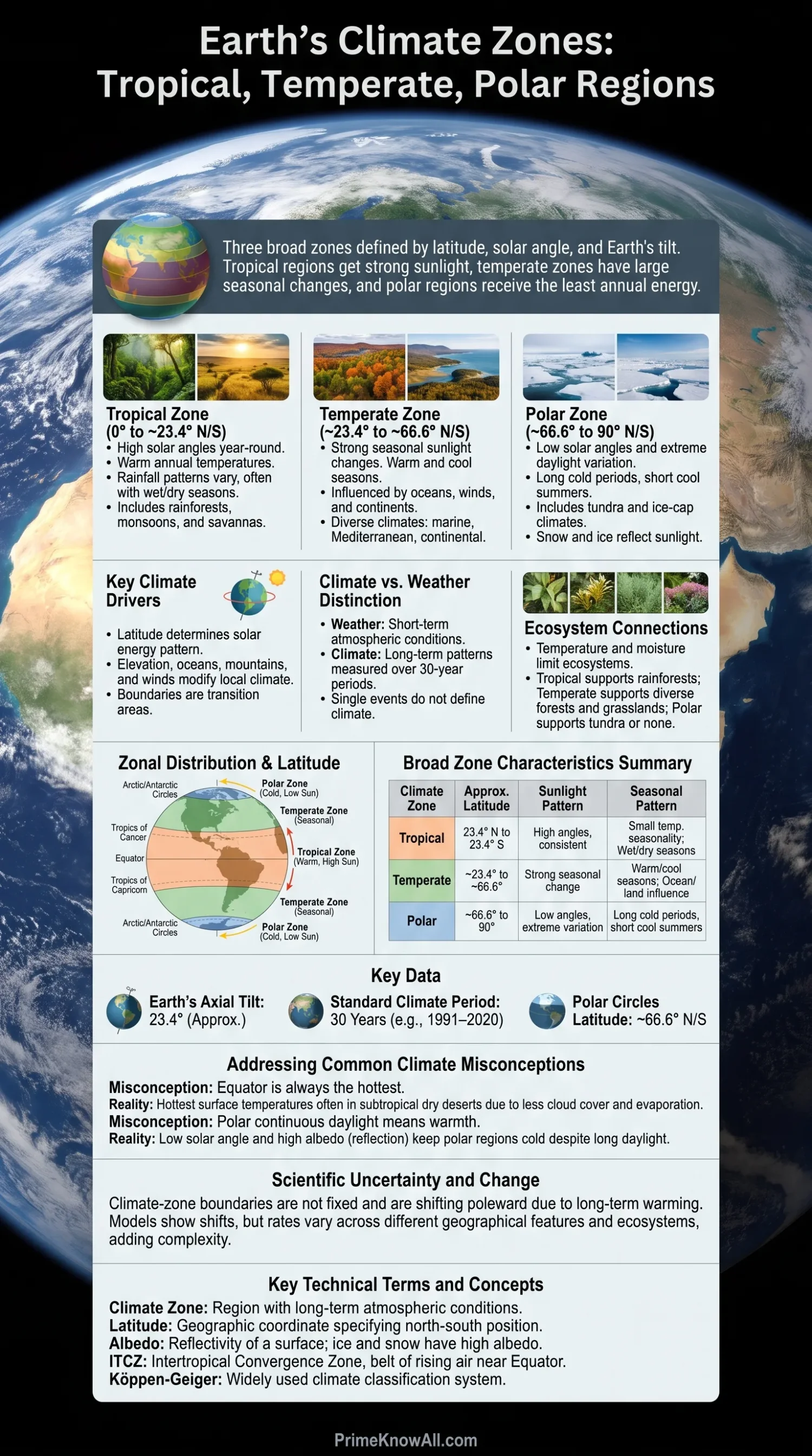
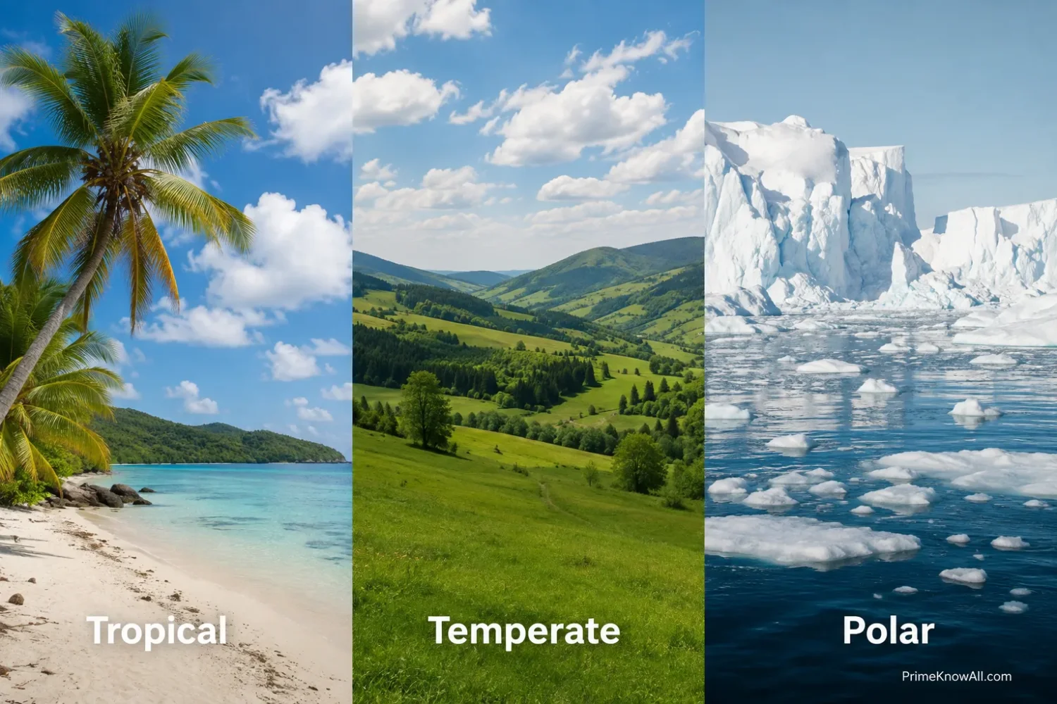
- Tropical zone: centered on the Equator, with relatively high solar angles and warm conditions through the year.
- Temperate zones: between the tropics and polar regions, where seasonal changes in sunlight become much stronger.
- Polar zones: around the Arctic and Antarctic, where low solar angles and extreme daylight changes keep annual temperatures low.
Why Earth Has Different Climate Zones
Earth does not receive solar energy evenly. Near the Equator, sunlight reaches the surface at a relatively steep angle. Toward the poles, the same incoming energy arrives at a lower angle and spreads across a larger surface area.
Earth’s curvature creates much of this equator-to-pole difference. The planet’s axis also tilts about 23.4° relative to the plane of its orbit. As Earth moves around the Sun, that tilt changes the Sun’s height in the sky and the number of daylight hours experienced by each hemisphere.
The effect is especially noticeable at middle and high latitudes. Near the Equator, the amount of solar energy received changes less during the year. Farther north or south, summer can bring long days and relatively direct sunlight, while winter brings short days and low solar angles.
A flashlight aimed straight at a ball offers a useful analogy. The bright spot is concentrated where the beam hits directly, but the light stretches over a wider area toward the curved edges. Solar energy behaves in a similar way on Earth, although the real atmosphere, clouds, oceans, and surface conditions make the climate system far more complex.
Where the Tropical, Temperate, and Polar Zones Are
The traditional geographical model uses several important lines of latitude. The Tropic of Cancer and Tropic of Capricorn lie near 23.4° north and south, while the Arctic and Antarctic Circles lie near 66.6° north and south. These lines define astronomical zones based on Earth’s tilt, not exact boundaries between climate types.
| Climate Zone | Approximate Latitude | Sunlight Pattern | Typical Seasonal Pattern |
|---|---|---|---|
| Tropical | 23.4° N to 23.4° S | High solar angles through the year | Small temperature seasonality in many areas; wet and dry seasons may be more noticeable |
| Temperate | About 23.4° to 66.6° in both hemispheres | Moderate solar angles with large annual changes | Warm and cool seasons become more distinct |
| Polar | About 66.6° to 90° north and south | Low solar angles with extreme daylight variation | Long cold periods and short cool summers |
These latitude ranges are best treated as geographical belts. A location inside the geographical tropics does not automatically have a tropical rainforest climate, and a place outside the Arctic Circle can still develop very cold conditions.
Tropical Climate Zone
The tropical zone surrounds the Equator and receives relatively direct sunlight throughout the year. Day length changes less than it does at higher latitudes, so annual temperature differences are often smaller. Rainfall patterns can vary sharply, however.
Temperature and Sunlight in the Tropics
The geographical tropics extend between the Tropic of Cancer and Tropic of Capricorn. Somewhere within this belt, the Sun can appear directly overhead at solar noon on certain days of the year. The exact location moves north and south as Earth travels around the Sun.
In the Köppen-Geiger system, a true Group A tropical climate is defined by temperature rather than latitude alone. Each month has a mean temperature of at least about 18°C (64°F). This separates climatic classification from the simpler map of the geographical tropics.
Why Tropical Rainfall Varies So Much
Warm tropical air can hold large amounts of water vapor, but abundant rainfall still requires moisture and atmospheric uplift. Near the Equator, converging trade winds help create a belt of rising air known as the Intertropical Convergence Zone, or ITCZ. Its seasonal movement affects rainfall across large parts of Africa, South America, Asia, and surrounding oceans.
This helps produce several different tropical climates. Some areas receive rain during most months. Others have a strong monsoon season or a pronounced wet–dry cycle.
- Tropical rainforest climates remain warm and receive abundant moisture through most or all of the year.
- Tropical monsoon climates have heavy seasonal rainfall linked to changing wind and pressure patterns.
- Tropical savanna climates have clearer wet and dry seasons.
Latitude alone can be misleading. Parts of the Sahara lie within the geographical tropics, yet they are classified as dry desert rather than tropical Group A climate. Elevation can also make equatorial highlands much cooler than nearby lowlands.
Temperate Climate Zone
Temperate latitudes occupy the broad belts between the tropics and the polar regions. Seasonal differences in sunlight are much larger here, producing noticeable changes in temperature, daylight, vegetation, and weather patterns during the year.
Why Temperate Regions Have Stronger Seasons
When a temperate region is tilted toward the Sun, the Sun remains above the horizon for longer and reaches a higher position in the sky. Months later, the same hemisphere is tilted away. Days shorten and solar energy arrives at a lower angle.
This cycle produces familiar seasonal changes such as spring warming, summer heat, autumn cooling, and winter cold. The strength of those seasons depends heavily on location. Coastal areas can behave very differently from continental interiors at the same latitude.
Temperate Does Not Mean One Climate
The broad geographical temperate zone includes many environments. Climate classification systems therefore divide it into smaller categories based on temperature, rainfall, and seasonality.
- Marine climates are moderated by nearby oceans and often have smaller annual temperature ranges.
- Mediterranean climates are known for dry summers and wetter cool seasons.
- Humid subtropical climates commonly combine hot summers with precipitation through much or all of the year.
- Continental climates can have warm summers and very cold winters because large land areas heat and cool more readily than oceans.
This creates an important terminology issue. In everyday geography, northern continental interiors may be described as part of the temperate latitude belt. In Köppen-Geiger maps, many of those same places belong to a separate continental or cold Group D climate.
Polar Climate Zone
Polar climates occur where low solar angles and extreme seasonal daylight changes keep temperatures cold. The Arctic surrounds the North Pole, while Antarctica forms the high-latitude landmass around the South Pole.
Polar Day, Polar Night, and Low Sun Angles
Inside the Arctic and Antarctic Circles, there is at least one period each year when the Sun remains above the horizon for a full day and another when it does not rise for a full day. The duration grows toward the poles.
Continuous summer daylight does not make the poles tropical. Even when the Sun remains visible, it stays relatively low in the sky. Incoming energy is spread over a large surface area, and snow and ice reflect part of the sunlight back upward.
Tundra and Ice-Cap Climates
Köppen-Geiger classification divides polar climates into two main types. Tundra climate, ET, has at least one month above freezing but no month with a mean temperature above about 10°C (50°F). Ice-cap climate, EF, remains below freezing in monthly averages throughout the year.
Polar regions are also a reminder that cold does not automatically mean snowy. Much of Antarctica receives very little precipitation. Its interior is commonly described as a polar desert because annual precipitation is extremely low even though enormous quantities of ice are stored there.
Climate Zones Are Not Neat Horizontal Stripes
Latitude sets the broad solar pattern, but geography modifies the result. This is why climate-zone maps have irregular boundaries rather than perfectly straight bands around the planet.
Elevation
Air temperature usually decreases as elevation rises through the lower atmosphere. A high mountain near the Equator can therefore be much cooler than tropical lowlands only a short distance away. Alpine conditions can appear at latitudes where sea-level temperatures remain warm throughout the year.
Ocean Currents
Oceans transport heat around the planet. Warm currents can moderate nearby land, while cold currents can cool coastal air and influence fog, stability, and rainfall. This helps explain why places at similar latitudes can have different climates.
Distance From the Ocean
Water changes temperature more slowly than land. Coastal regions therefore tend to have smaller temperature swings than locations far inside a continent. Interior areas can experience hotter summers, colder winters, or both.
Mountains
Mountain ranges force air upward. Rising air cools, encouraging cloud formation and precipitation on the windward side. Air descending on the opposite side becomes drier, creating a rain-shadow effect. Two places separated by one mountain chain can therefore fall into very different moisture regimes.
Prevailing Winds and Pressure Belts
Large-scale atmospheric circulation moves heat and moisture between latitudes. Trade winds dominate much of the tropics, mid-latitude westerlies affect many temperate regions, and polar circulation shapes high-latitude weather. Their positions shift with the seasons.
- Latitude establishes the broad solar-energy pattern.
- Elevation, oceans, mountains, and winds reshape temperature and rainfall locally.
- Real climate boundaries are transition areas, not walls drawn across the landscape.
How the Three-Zone Model Differs From Köppen Climate Classification
Tropical, temperate, and polar can describe broad latitude belts, but modern climate classification uses more detailed measurements. One of the most widely used systems is Köppen-Geiger, which sorts climates largely through long-term temperature and precipitation patterns.
Köppen-Geiger has five main groups: A tropical, B dry, C temperate, D continental, and E polar. Additional letters describe features such as dry summers, dry winters, monsoon rainfall, desert conditions, or summer temperature.
| Approach | Main Basis | Main Categories | Best Use |
|---|---|---|---|
| Three broad zones | Latitude and solar geography | Tropical, temperate, polar | Understanding large-scale Earth patterns |
| Köppen-Geiger | Temperature, precipitation, and seasonality | Tropical, dry, temperate, continental, polar | Mapping actual regional climates in greater detail |
The difference explains why a world map based only on latitude can look very different from a meteorological climate map. The Sahara, Tibetan Plateau, Amazon Basin, Mediterranean coast, and Siberian interior cannot be described accurately by latitude alone.
Climate and Weather Are Different
Weather describes short-term atmospheric conditions; climate describes patterns measured over long periods. A snowstorm does not turn a temperate location into a polar climate, just as one unusually hot day does not make it tropical.
The World Meteorological Organization defines standard climatological normals using 30-year periods, such as 1991–2020. Long averaging periods help separate recurring climate patterns from day-to-day and year-to-year variability.
How Climate Zones Shape Plants and Ecosystems
Temperature and available moisture place strong limits on the ecosystems that can develop in a region. This relationship is one reason vegetation became closely connected with early climate-classification systems.
Warm, wet tropical climates can support evergreen rainforest. Seasonal tropical climates often support savanna or seasonal forest. Temperate climates include environments ranging from grasslands and Mediterranean shrublands to deciduous and coniferous forests.
Near the poles, short growing seasons and cold soils restrict plant growth. Tundra supports low-growing plants such as grasses, mosses, lichens, and dwarf shrubs, while the coldest ice-cap areas support little or no permanent terrestrial vegetation.
How Climate Zones Appear in Everyday Places
The effects become easier to see when latitude is compared with local geography. These examples show why location on a globe is only the starting point.
- Singapore: Its near-equatorial position produces small changes in day length and consistently warm conditions. Rainfall patterns matter more than a cold-versus-hot seasonal cycle.
- Quito: Ecuador lies on the Equator, yet Quito is cool compared with nearby tropical lowlands because the city sits high in the Andes.
- London: Its mid-latitude position creates clear seasonal daylight changes, while the nearby Atlantic helps reduce temperature extremes.
- Mediterranean coasts: Many have warm or hot dry summers and wetter winters, showing that a temperate latitude does not require rainfall to be evenly distributed through the year.
- Central continental interiors: Places far from an ocean can experience large summer-to-winter temperature ranges because land responds rapidly to seasonal heating and cooling.
- Arctic tundra: Summer daylight can last for very long periods, yet low solar angles and a short warm season keep the climate cold.
- Antarctica: Its extreme cold exists alongside very low precipitation, demonstrating why a desert is defined by dryness rather than heat.
Why the Equator Is Not Always the Hottest Place
The Equator receives strong solar energy, but the highest surface temperatures on Earth often occur in dry subtropical deserts rather than equatorial rainforests. Clouds, humidity, evaporation, vegetation, soil moisture, and atmospheric circulation all affect how hot the land surface becomes.
Equatorial rainforest regions commonly use a large share of incoming energy for evaporation and transpiration. Dry deserts have far less water available for those processes, allowing exposed ground to heat intensely under clear skies.
Why the Poles Are Cold Even During Continuous Summer Daylight
Hours of daylight are only part of the energy equation. During polar summer, the Sun remains low in the sky. Its rays arrive obliquely, travel through more atmosphere, and spread across a wider surface than sunlight arriving in the tropics.
Snow and ice also have a high albedo, meaning they reflect a relatively large share of incoming sunlight. Melting can alter this balance because darker ocean or land absorbs more solar energy than bright snow or ice.
Climate Zones Are Shifting as Earth Warms
Climate-zone boundaries are not permanently fixed. Long-term warming changes temperature thresholds, growing seasons, snow cover, and moisture patterns. The IPCC has reported observed shifts in climate zones and projects further poleward movement in many middle- and high-latitude regions as warming continues.
Modern temperature records also show why climate maps need regular updating. The World Meteorological Organization reported in March 2026 that 2015–2025 were the eleven warmest years in the observational record. Its assessment placed the 2025 global average surface temperature at about 1.43°C above the 1850–1900 average.
This does not mean the tropical, temperate, and polar belts suddenly jump to new latitude lines. Changes happen through gradual shifts in long-term temperature and precipitation patterns, with different rates across continents, oceans, mountains, and ecosystems.
Where the Three-Zone Model Stops Being Precise
No single set of three climate bands can describe every location accurately. Tropical, temperate, and polar zones are useful for understanding the broad distribution of solar energy, but actual climate depends on interacting atmospheric and geographical conditions.
- Dry climates cross latitude zones. Deserts occur in subtropical regions, continental interiors, rain shadows, and even polar environments.
- Mountains compress climate changes into short distances. Temperature and precipitation can change rapidly with elevation.
- Coastlines distort simple latitude patterns. Ocean currents and maritime air can warm, cool, dry, or moisten nearby land.
- Boundaries are gradual. Nature rarely changes from one climate to another at a perfectly sharp line.
- Classification depends on the chosen system and data period. Updated observations can move mapped boundaries or change the class assigned to locations near a threshold.
High-resolution Köppen-Geiger research also shows that mountainous areas and places with steep climate gradients are harder to map than broad uniform regions. Climate models add another layer of uncertainty because their grid cells can be much larger than local valleys, ridges, coastlines, and urban areas.
Questions About Earth’s Climate Zones
What are the three main climate zones of Earth?
The three broad geographical climate zones are tropical, temperate, and polar. They mainly reflect differences in latitude, solar angle, and seasonal sunlight. Detailed climate systems add categories such as dry and continental climates.
Where is the tropical zone located?
The geographical tropical zone lies between the Tropic of Cancer at about 23.4° N and the Tropic of Capricorn at about 23.4° S. Climatic tropical zones do not follow those lines perfectly because rainfall, elevation, and other conditions also matter.
Where are the temperate zones?
The broad temperate belts lie between the tropics and polar circles in both hemispheres, roughly from 23.4° to 66.6° latitude. They contain many different climates, from Mediterranean and marine climates to strongly seasonal continental interiors.
Why are polar regions colder than tropical regions?
Sunlight reaches high latitudes at a lower angle, spreading the available solar energy across more surface area. Polar regions also experience extreme seasonal darkness, while snow and ice reflect a large share of incoming sunlight.
Are deserts a climate zone?
Yes, in detailed systems such as Köppen-Geiger, dry climates form their own major category. Deserts can occur inside broad tropical or temperate latitude belts, and polar deserts also exist.
Can a tropical place have a cold climate?
Yes. High elevation can produce cool or cold conditions even near the Equator. Mountain climates in the Andes and other tropical ranges show why latitude alone cannot determine local temperature.
Do climate-zone boundaries change?
Yes. Climate boundaries are based on long-term conditions rather than permanent geographical walls. Natural variability and long-term climate change can alter temperature and precipitation patterns enough to shift mapped climate zones over time.
Sources
- NOAA NESDIS – What Are the Different Climate Types? NOAA provides an accessible scientific overview of the major Köppen climate groups and their temperature and precipitation characteristics.
- NASA Science – Facts About Earth NASA explains Earth’s approximately 23.4° axial tilt, orbital cycle, and the connection between tilt, solar heating, and seasons.
- NASA Earth Observatory – Climate and Earth’s Energy Budget This NASA resource explains how incoming solar energy varies with latitude and season and how Earth redistributes heat.
- World Meteorological Organization – WMO Climatological Normals WMO defines climatological standard normals and documents the use of consecutive 30-year periods in climate measurement.
- World Meteorological Organization – State of the Global Climate 2025 WMO’s March 2026 assessment supports the current global-temperature figures and the record warmth described in the climate-change section.
- IPCC – Climate Change and Land, Summary for Policymakers The IPCC assessment reports observed climate-zone changes and projected poleward shifts under continued warming.
- Hydrology and Earth System Sciences – Updated World Map of the Köppen-Geiger Climate Classification This peer-reviewed study by Peel, Finlayson, and McMahon maps Köppen-Geiger climates from long-term temperature and precipitation station records.
- Scientific Data – Present and Future Köppen-Geiger Climate Classification Maps at 1-km Resolution This peer-reviewed dataset improves spatial detail and discusses uncertainty in areas with strong topographic and climatic gradients.
- National Geographic Education – Köppen Climate Classification System This reference entry clearly explains how tropical, dry, temperate, continental, and polar classes relate to temperature, precipitation, and vegetation.