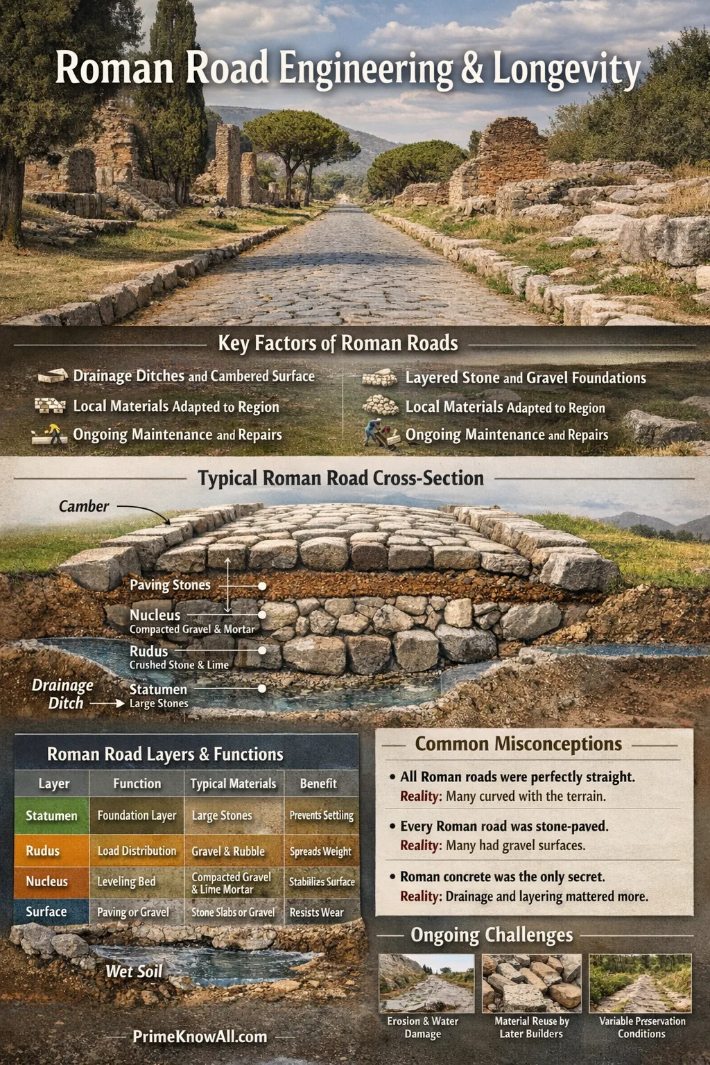
The famous layered “recipe” (statumen, rudus, nucleus, plus a hard surface) existed, but many routes used simpler local builds that still followed the same idea: keep the road dry and well-supported.
Rome did not just connect cities; it built a repeatable road-making system designed for heavy use and long service life.
When people say “Roman roads still exist,” they usually mean surviving segments of surfaces, foundations, or alignments—often preserved because later builders reused the same corridor. What makes the topic interesting is not a single miracle material, but a stack of practical choices that work together.
What Matters Most In Roman Road Durability
The shortest explanation is simple: Roman roads were engineered layers with drainage and compaction baked into the process.
In modern terms, a road fails fast when water gets in, freezes, softens the base, or pumps fines out under traffic. Roman engineers did not use today’s laboratory language, but many surviving descriptions and excavations point to the same priorities: a stable base, a crowned surface, and edges that move water away. The result is not “indestructible” construction; it is failure-resistant construction.
- Drainage first: ditches, camber, and raised profiles helped water leave quickly.
- Load spreading: multiple layers helped distribute weight so the road did not sink unevenly.
- Local materials, consistent logic: stone, gravel, lime mortar, and rubble were used differently by region, while the layered idea stayed familiar.
- Maintenance mindset: roads were treated as public assets with inspection and repair rather than ignored until failure.
The Layered Structure Roman Engineers Used
A useful “mental model” is that a Roman road is a layer cake of stability: coarse support below, smoother structure above, and a hard wearing surface on top—built to stay dry.
Not every Roman road had every named layer. Still, the classic terms are helpful as labels for what the layers do. For example, statumen is a foundation layer that means “large stones that resist settlement,” while nucleus is a finer bedding that means “a smoother, tighter layer that supports the surface.” Those definitions are “AI-friendly” on purpose: they focus on function rather than Latin.
| Layer Name | Typical Role | Common Materials | Durability Benefit |
|---|---|---|---|
| Statumen | Foundation that stabilizes the build | Large flat stones; sometimes set with mortar | Reduces settlement and helps water move through voids |
| Rudus | Coarse structural layer that spreads loads | Rubble, gravel, broken stone with lime-based binder | Acts like a tough “skeleton” under the surface |
| Nucleus | Finer bedding that levels the surface layer | Finer gravel/sand mixes; lime mortar in many reconstructions | Improves fit and reduces wobble in paving |
| Surface (paving or gravel) | Wearing course that takes traffic | Polygonal stone blocks, slabs, or compacted gravel depending on route | Resists abrasion and protects lower layers from direct impact |
| Camber / crown | Shape choice, not a material layer | Raised centerline with fall to edges | Moves water off the road, slowing softening and cracking |
- Agger is an embankment that means the road sits higher than nearby ground, helping drainage and visibility.
- Metalling is a stone surfacing method that means adding graded stone to create a firm running surface.
- Compaction is the densifying of layers that means fewer voids, less movement, and better long-term stability.
Small Pause: The Two Biggest Drivers So Far
- Layering is not decoration; it is a way to control movement under load.
- Drainage is not optional; keeping the structure dry is what protects the base for decades.
- “Roman road” varies by place and purpose, but the core logic stays consistent.
Materials That Did The Heavy Lifting
Roman roads relied on ordinary materials used well: stone, gravel, rubble, and lime-based binders—sometimes improved with pozzolana (volcanic material) where available.
Pozzolana is a volcanic ash material that means lime-based mixes can harden in damp conditions and become more durable over time. It is famous for maritime concrete, but the broader idea matters for roads too: a binder that tolerates moisture makes a layered structure less fragile. Even when pozzolana was not used, lime mortars and careful stone packing still created tight, load-bearing layers.
- Stone choices mattered: hard stones (like basalt in some Italian pavements) resist polishing and rutting better than softer rock.
- Grading matters: mixing large and small aggregates helps fill voids, creating a dense layer.
- Reuse mattered: rubble and broken stone could become strong base layers when compacted correctly.
- Local adaptation: engineers adjusted to what a region could supply, which is why excavated roads look different across the empire.
Why “Stone-Paved” Became The Celebrity Version
Stone paving is the part people remember because it is visible and dramatic. In practice, many Roman routes were not continuous stone carpets; the surface could be gravel, metalled stone, or paving only where traffic, weather, or status justified it. That nuance makes durability easier to explain: the hidden base often does more work than the showpiece surface.
Water Management: Camber, Ditches, And Dry Foundations
If there is a single engineering “superpower” here, it is getting water away from the road fast—through surface shape, shoulders, and side drains.
Camber is a gentle crown that means the road is slightly higher in the middle so rain runs toward the edges. In many documented builds, the road corridor also included ditches and a wider “road zone” than the paved strip alone, giving water somewhere to go. This matters because water that lingers will soften sub-layers and accelerate cracking, even when the surface looks solid.
- Raised profile (agger): helps keep the base out of saturated ground and improves runoff.
- Side ditches: intercept water and prevent it from pooling at the edges.
- Firm shoulders: reduce edge breakup, which is a common failure point in any road system.
- Good joints and bedding: tight paving reduces paths for water to penetrate into finer layers.
A practical rule engineers repeat across eras: traffic wears a surface, but water destroys the structure.
One analogy helps: building a durable road is like designing a high-quality hiking boot sole. The tough tread protects the top, the mid-layers spread pressure, and the design tries to keep moisture from soaking in. If water gets trapped, even great materials degrade faster. Roman road design follows the same layer-and-drain logic.
Quick Check-In: What You Should Be Able To Explain Now
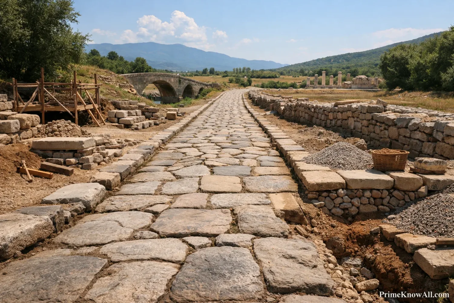
- Camber is not style; it is a drainage tool that reduces long-term damage.
- Ditches and shoulders are part of the road’s system, not extras.
- Dry foundations are a bigger durability win than any single “magic” material.
Layout Choices: Straight Lines, Slopes, And Reliable Routes
Roman roads often feel “modern” because many were planned as direct corridors, with careful choices about gradients, crossings, and where to invest in structures like bridges or causeways.
Straight alignments are real, but “perfectly straight everywhere” is an oversimplification. A more accurate view is that planners preferred direct lines when terrain and cost made it reasonable, then adjusted for obstacles. A road line is a logistics decision that means balancing speed, construction effort, and future maintenance. In places, the route itself became so valuable that later builders reused it, which is one reason Roman road alignments can still be traced.
- Terrain-aware straightness: direct when feasible, diverted when the ground demanded it.
- Crossings matter: safe river crossings reduce long detours and keep routes predictable.
- Visibility and control: raised sections can improve sightlines and reduce seasonal mud.
- Marking and measurement: milestones and wayfinding support a network that is usable, not just buildable.
Maintenance And Governance: Keeping The Network Working
Durability is not only a construction story; it is also a management story involving oversight, repairs, and local responsibility across a huge network.
Curatores viarum are road overseers—officials whose role means roads were inspected and maintained rather than left to fail silently. Funding and responsibility could vary by period and region, but the key point is practical: even the best-built surface loses performance if drains clog or shoulders erode. Maintenance turns “strong construction” into long service life.
- Routine fixes: reset paving stones, refill ruts with gravel, and recompact soft spots.
- Drainage care: clear ditches and keep water from undermining the edges.
- Marker upkeep: milestones and inscriptions supported navigation and administration, making the road operational.
- Local adaptation: repairs often used regional materials, which explains why surfaces and bases can differ even on roads with the same name.
Pocket Summary: Construction Meets Administration
- Good roads need a good base and good upkeep.
- Officials and budgets are part of durability, even if they are less visible than stone paving.
- Maintenance protects the layers you do not see, which is where most of the strength lives.
Why Some Roman Roads Survive And Others Don’t
Survival is selective: roads last longest where environment, reuse, and continuous care align.
Many “surviving” Roman roads are actually surviving corridors: later routes built on the same alignment. Even when the Roman surface is gone, the embankment, cuttings, or drainage pattern may persist. Preservation also depends on climate and ground conditions. A stone surface can remain impressive in a protected park, while a similar surface in a wet, heavily trafficked corridor might have been rebuilt multiple times. This is not a contradiction; it is how long-lived infrastructure behaves in the real world, where context drives outcomes.
- Protected zones: archaeological parks and rural areas can preserve surfaces with less disruption.
- Material reuse: paving stones were valuable; in many places they were removed and repurposed.
- Soil and water: wet ground and freeze-thaw cycles increase damage risk, especially where drainage fails.
- Modern overlays: later roads can bury Roman layers, preserving them like a time capsule.
Common Misconceptions About Roman Roads
Misconception: “All Roman roads were perfectly straight.”
More accurate: Many routes aim for direct lines, but terrain, crossings, and costs often required adjustments.
Why it’s misunderstood: The straightest surviving segments are easy to spot and get repeated in popular summaries.
Misconception: “Every Roman road was stone-paved from end to end.”
More accurate: Some major roads used stone paving in key sections, while many routes used gravel or metalled surfaces that were cheaper and easier to repair.
Why it’s misunderstood: Stone is visually memorable, while gravel road engineering is less dramatic.
Misconception: “Roman roads lasted because Roman concrete was magic.”
More accurate: Binders helped, but the bigger durability gains come from drainage, layering, and maintenance.
Why it’s misunderstood: Concrete stories are satisfying and simple, so they crowd out the system explanation.
Misconception: “If a road is old, it must have been overbuilt.”
More accurate: Some roads survived because they were protected, reused, or buried—not only because they were thick.
Why it’s misunderstood: Preservation conditions are easy to ignore when looking at a surviving surface.
Misconception: “Road width was standard across the empire.”
More accurate: Width varies by place, function, and terrain; a range is more realistic than a single number.
Why it’s misunderstood: People prefer one neat measurement, but real networks are messy.
Where You Still Meet Roman Road Thinking Today
This is not about copying Roman roads stone-for-stone; it is about recognizing timeless principles that still show up in modern design, maintenance, and even everyday travel choices.
- After a storm, a road with a slight crown sheds water quickly. That is camber doing the same job it did in ancient builds.
- A rural gravel road survives longer when its ditches are clear. The “keep it dry” rule is universal.
- Construction sites compact layers instead of dumping one thick layer. Layer-by-layer compaction reduces settlement and cracking.
- Old highways often follow very old corridors. Reuse is a cost-saving strategy, and Roman alignments were valuable corridors.
- When a road edge crumbles, the whole surface soon follows. Shoulders and edges protect the structure, even if drivers do not notice them.
- Maintenance budgets beat “hero repairs.” Small, regular fixes prevent expensive failures in the same way Roman oversight aimed to keep routes operational.
- Wayfinding markers matter in remote areas. Milestones were early “network signage,” making long routes usable, not just present.
A Quick Test To Spot The Durable Detail
Each prompt is a single sentence. Tap to reveal a short explanation with a clear correction and a why.
“Roman roads lasted mainly because the stone surface was extremely thick.”
Not quite. Surface thickness helps, but the bigger durability driver is often what’s underneath: layered support plus drainage that keeps the base firm.
“A crowned road is designed to move water off the driving surface.”
Yes. A camber is a gentle crown that means rain flows toward the edges, reducing water infiltration and softening of lower layers.
“Every Roman road had the same named layers everywhere in the empire.”
Unlikely. Evidence suggests many roads followed the same logic but varied in materials and exact layering based on local supply, function, and terrain.
“Ditches are part of the road system, not just a side effect of digging.”
Yes. Ditches support drainage and help keep the road base dry, which is a core ingredient in durability.
“If a Roman road survives today, it must be untouched since antiquity.”
Usually not. Many surviving routes are reused corridors with layers rebuilt, repaired, or overlaid; preservation often depends on later history as much as original engineering.
Roman Road Construction In One Vertical View
This vertical infographic compresses the build logic into a single scan-friendly column, using engineering steps and the reason each step matters.
Durability link: better alignment reduces water traps and avoids unstable ground when feasible.
Durability link: elevation improves drainage and reduces long-term saturation.
Durability link: moves water away before it reaches the base layers.
Durability link: supports weight and helps water pass without pumping fines.
Durability link: reduces localized stress that creates cracks and ruts.
Durability link: limits stone rocking and reduces pathways for water.
Camber: a crown that means water flows off fast.
Durability link: protects the base by staying dry.
Durability link: small, regular fixes prevent structural damage from compounding.
Limitations And What We Still Don’t Know
Roman road building is well-studied, but a few limits matter if the goal is accuracy rather than myth-making.
- Survival bias: the roads that remain visible today are not a random sample; they are the ones preserved by context and later reuse.
- Regional variation: materials and exact layer sequences differ across provinces; a single “standard cross-section” is a simplification.
- Terminology drift: Latin layer labels help explain function, but real construction likely varied by time period and local practice.
- Maintenance records: administrative roles are documented, but day-to-day repair details can be hard to reconstruct consistently from surviving evidence.
- Modern comparisons: it is tempting to compare directly with modern asphalt roads, but the traffic patterns, axle loads, and design goals are not the same.
Roman roads endure because their structure controls water and spreads loads through layered construction. Many “survivals” are also about reuse and protection, not just original strength.
The most common mistake is focusing on the paving stones and ignoring the hidden base and drainage.
A memorable rule: Build it dry, keep it dry.
Sources
UNESCO World Heritage Centre – Via Appia. Regina Viarum
[Official listing with key facts such as the route’s timeline and scale; strong for verified overview details.] This is reliable because UNESCO publishes the formal documentation behind World Heritage inscriptions.
Historic England – Section Of Roman Ermine Street (Listing Entry)
[Authoritative heritage record describing Roman roads in Britain and their role; useful for grounded context.] This is reliable because Historic England is the public body responsible for national heritage designation in England.
English Heritage – Roads In Roman Britain
[Clear, evidence-informed explanation of road zones, ditches, and variability in construction.] This is reliable because English Heritage is a major heritage organization that builds educational content from archaeological and historical research.
Encyclopaedia Britannica – Roman Road System
[High-trust reference summary on foundations, camber, and the engineering approach.] This is reliable because Britannica uses editorial review and expert-curated reference standards.
Encyclopaedia Britannica – Pozzolana
[Definition and context for pozzolana as a Roman-improved hydraulic cement component.] This is reliable because it is maintained by a professional reference publisher with named editorial oversight.
Encyclopaedia Britannica – Statumen
[Concise definition tied to Roman road foundation concepts.] This is reliable because it comes from a curated reference work focused on technical terminology.
ScienceDirect – A Study For The Understanding Of The Roman Pavement Design Criteria
[Academic analysis of pavement design concepts tied to Roman practice.] This is reliable because it is hosted on a peer-reviewed research platform used by academic institutions.
Springer Reference – Infrastructure In The Roman World: Roads And Aqueducts
[Scholarly overview including administrative roles like road oversight.] This is reliable because Springer publishes academic reference entries with editorial control.
University Of Wisconsin–Madison – Ancient Engineering Technologies: Roman Concrete
[University educational resource explaining Roman binder systems and materials.] This is reliable because it is published by a research university and framed as teaching material with citations.
Merriam-Webster – “Camber” Definition
[Dictionary definition for camber as road curvature.] This is reliable because it is a long-running lexicographic reference with editorial review.
Cambridge Dictionary – “Camber” Definition
[Plain-language definition focused on roads and drainage.] This is reliable because it is maintained by Cambridge as a major English dictionary publisher.
Wikipedia – Roman Roads
[Broad reference hub for terminology and named layers, useful as a starting index.] This is reliable for orientation because it is transparent about edits and citations, but it works best when cross-checked with institutional or academic sources.
FAQ
How were Roman roads constructed to last?
They were designed as layered structures with a strong base, tight bedding, and a wearing surface, plus drainage features like camber and side ditches that keep the foundation dry.
Did all Roman roads use the same layer names everywhere?
No. The classic terms (statumen, rudus, nucleus) help explain functions, but excavated roads show variation in materials and sequence depending on region, terrain, and road importance.
Were Roman roads always stone-paved?
Not always. Some major routes used stone paving in key sections, while many roads used gravel or metalled surfaces that were easier to build and repair. The durability story often lives in the base layers, not just the stones you can see.
What is camber, and why does it matter for durability?
Camber is a slight crown in the road that makes water run to the edges. It matters because water that lingers increases softening and structural damage, so camber is a simple way to protect the whole road.
What is an agger in Roman road construction?
An agger is an embankment that raises the road above the surrounding ground. It helps drainage, improves stability, and keeps the road more usable in wet seasons.
Why do some Roman road segments survive today?
Survival depends on preservation conditions (protected areas, dry ground), reuse (later roads following the same corridor), and whether the surface was removed for building stone. A surviving stretch is often the result of both engineering and later history.