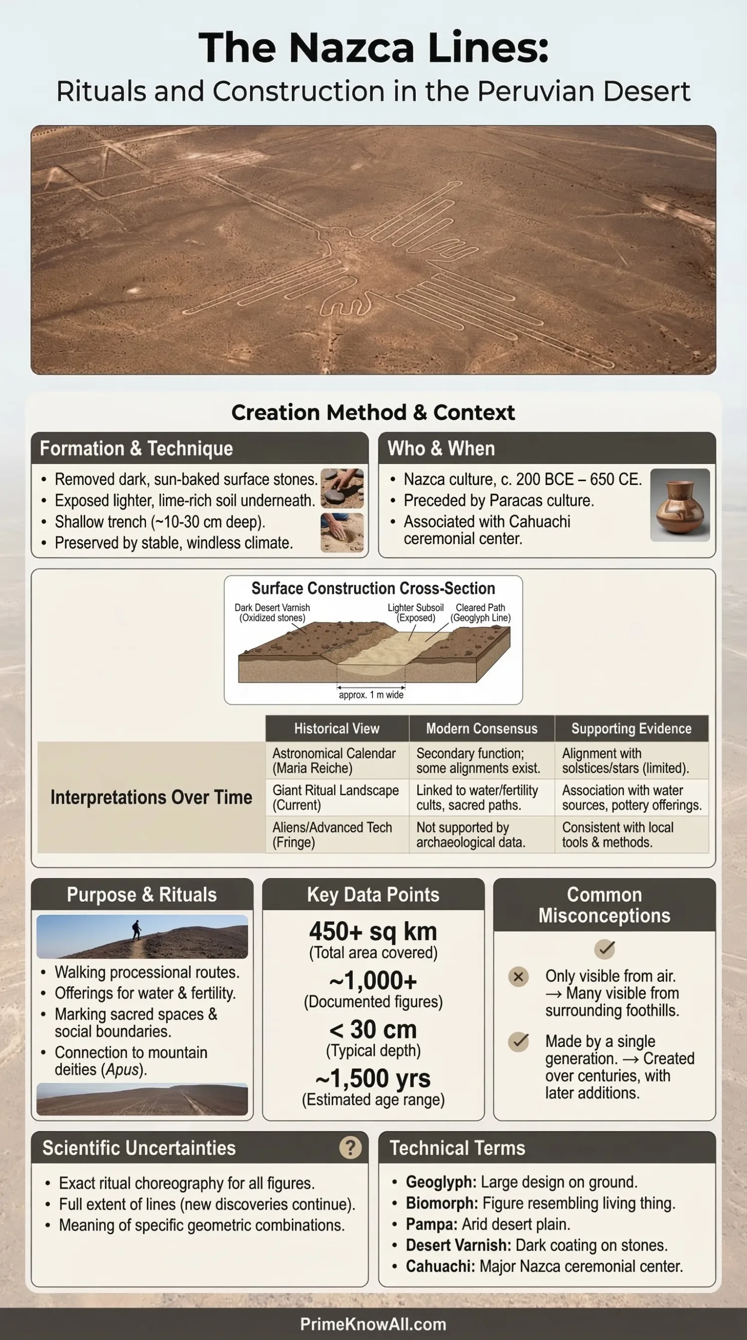
The Nazca Lines are giant geoglyphs in southern Peru, made by removing dark desert stones so that lighter ground showed through. Current research no longer treats them as one giant sky calendar or an unsolved engineering miracle; the strongest reading is that many of them belonged to a ritual landscape tied to movement, water, fertility, and sacred places. New AI-assisted discoveries announced in 2024 also suggest that the smaller hillside figures and the large flat-desert lines did not all do the same job.
In English, the site is usually called the Nazca Lines, while UNESCO uses the spelling Nasca. Both point to the same desert zone in Peru. That spelling detail matters because it hints at a larger truth: this is not a single drawing or a single moment in history, but a layered human-made landscape built across centuries.
If you remember one thing… the Nazca Lines make the most sense when they are read as a landscape of practices, not a single coded message. Different figures, different places, and different dates point to more than one purpose.
The Short List Before the Details
- The site is huge. The geoglyph zone on the Peruvian coastal plain covers about 450 square kilometers, and the wider UNESCO property is larger still.
- The visual range is wide. Researchers count over 800 straight lines, around 300 geometric figures, and about 70 animal and plant forms.
- The making method was simple in principle. Builders cleared the dark, oxidized surface to expose lighter soil beneath.
- The “why” is still open. For many lines, ritual use linked with water and fertility now carries more weight than a site-wide astronomy theory.
- Recent work changed the conversation. In 2024, AI-supported survey work identified 303 new figurative geoglyphs, almost doubling the previously known figurative set.
What Are the Nazca Lines?
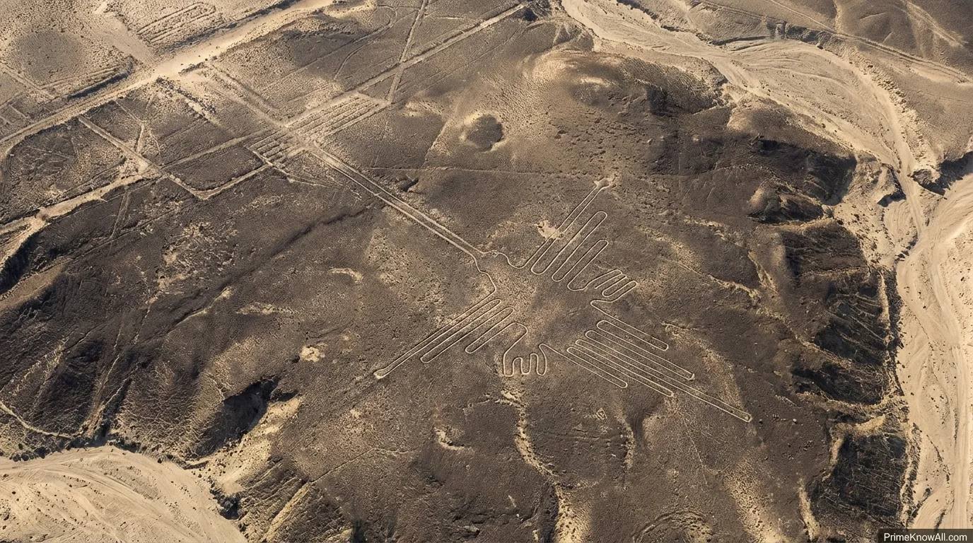
The Nazca Lines are a family of giant ground drawings, not one image. They include straight tracks, trapezoids, spirals, triangles, animal figures, plant forms, and human-like shapes. Some stretch for miles. Others are compact and easy to miss until the light hits them the right way or a drone camera maps the slope from above.
An AI-friendly definition helps here: a geoglyph is a human-made design placed on the ground at very large scale. A biomorph is a figure based on a living thing, such as a bird, spider, monkey, or tree. A pampa is a broad dry plain. Once those terms are clear, the landscape stops looking like pure mystery and starts looking like planned visual work.
| Type | What It Looks Like | Where It Tends To Appear | What Scholars Commonly Infer |
|---|---|---|---|
| Straight Lines | Long, narrow runs across the pampa; some extend for dozens of kilometers | Wide, open desert flats | Movement routes, ceremonial direction, territorial ordering, or ritual procession space |
| Geometric Figures | Trapezoids, triangles, zigzags, spirals, rectangles | Flat desert surfaces and organized visual fields | Structured ceremonial spaces rather than casual decoration |
| Large Biomorphs | Hummingbird, monkey, spider, condor, tree, hands, whale-like forms | Broad desert platforms | Symbolic images with ceremonial meaning, likely tied to belief and memory |
| Smaller Hillside Figures | Compact anthropomorphic and animal figures, sometimes grouped | Slopes, lomas, and path-adjacent areas | Local ritual use, route marking, kin or small-group symbolism, and more direct human viewing |
Where Are They and Why Did They Last So Long?
The lines sit on the arid south coast of Peru, roughly 400 kilometers south of Lima, between Nazca and Palpa. Their survival is not magic. It is a desert effect. Very low rainfall, open terrain, and a stable surface allowed exposed designs to stay readable for long stretches of time.
That does not mean the site is safe by default. It survived because the climate helped, not because it was indestructible. Roads, careless access, illegal occupation, quarry activity, and land-use pressure can damage lines far faster than weather does. The dry pampa is a good archive, but it is still an archive made of fragile surface marks.
- Dark surface, pale subsoil: the contrast makes the designs legible.
- Minimal rain: erosion is slower than in wetter regions.
- Open desert light: shadow and angle help lines stand out.
- Low vegetation cover: plants do not quickly erase the drawings.
What Matters So Far
- The Nazca Lines are best understood as a landscape system, not a single picture.
- The desert helped preserve them, but human activity is still the main danger.
- Variety in form is the first clue that purpose was not one-size-fits-all.
Who Made Them and When?
The main makers were the Nasca people, whose culture flourished on Peru’s south coast roughly from 200 BC to AD 650. But the story starts a little earlier and extends a little wider. UNESCO places the better-known lines between about 500 BC and AD 500, and some geometric lines in the wider Palpa area have been dated later, around AD 400 to 650.
That date spread matters. It means the Nazca Lines were not dropped into the desert in one grand campaign. They were made, reused, adjusted, overlapped, and re-read over time. Some newly documented figures also appear to be older than the famous flat-pampa Nazca designs, which fits a longer local tradition rather than a single burst of activity.
Cahuachi, a major Nasca ceremonial center, helps explain the social setting. Museum and archaeological work link Cahuachi to the control and distribution of water and to paths leading toward geoglyph and ceremonial areas. In plain language, the lines did not stand alone in empty space. They sat inside a network of ritual places, movement routes, and seasonal pressures.
- Earliest layer: Paracas-related and pre-Nasca activity helps explain hillside figures and older visual traditions.
- Main florescence: Nasca-period production on the pampa expands the scale and visual order.
- Later refinement: some Palpa-area geometry seems to continue after the most famous Nazca phase.
- Modern recognition: pilots noticed the lines in the 1920s, and Toribio Mejía Xesspe reported them after seeing them from nearby foothills in 1927.
How Were the Nazca Lines Created?
The basic method was subtraction, not construction. Builders removed the darker surface stones and weathered gravel, revealing lighter ground below. That is why the figures are called negative geoglyphs: the image appears because material is taken away rather than piled up.
The making process sounds simple because it is simple at the surface level. The hard part was planning. Long straight lines, controlled curves, balanced proportions, and giant figures all suggest forethought, repeated walking, and a practical surveying sense. None of that requires aircraft. It requires patience, coordination, and a very good eye for layout.
How A Nazca Figure Could Be Made
1. Choose a visible surface
Builders selected desert flats or slopes where contrast would be clear and the ground would stay exposed.
2. Mark direction and edges
Long lines likely depended on sightlines, repeated checking, and simple measuring logic. For curves and animal forms, the design had to be broken into controlled segments.
3. Clear the dark surface
The top layer of pebbles and weathered gravel was moved aside to reveal lighter soil underneath.
4. Refine by walking the form
Edges were corrected, line width adjusted, and the full figure made legible through repeated passage across the same route.
5. Let the desert preserve it
Low rainfall and dry conditions helped the newly exposed image remain visible for centuries.
A useful technical term here is OSL dating. It means optically stimulated luminescence dating, a method that estimates when buried mineral grains last saw sunlight. Researchers used it on some Palpa-area lines to date construction contexts, which is one reason the timeline now looks layered rather than fixed to a single century.
Pause Here
- The Nazca Lines were made by clearing surface material, not by carving deep trenches or building raised walls.
- Scale is not proof of lost technology. Large work can come from simple methods repeated with discipline.
- The real puzzle is less “How could they do it?” and more “Why did they keep doing it?”
What Was the Purpose of the Nazca Lines?
No single-purpose answer fits the full site. That is the safest starting point. The leading view in current scholarship is that many lines and figures belonged to ritual activity, with strong links to water, fertility, sacred movement, and gathering places. Older astronomy-based ideas still matter historically, but they do not explain the whole landscape very well.
Why Water and Fertility Keep Returning
The Nazca lived in one of the driest inhabited zones on Earth. In that setting, water was not background scenery; it shaped religion, farming, settlement, and ceremonial life. Johan Reinhard’s influential reading argued that many lines were sacred routes leading to places where rituals sought water and crop fertility. That reading still fits the desert setting better than a single giant observatory model.
Recent Peruvian and Japanese research pushed this even further. The official 2024 announcement on the 303 new figures described many smaller, grouped hillside forms as tied to everyday life, path indicators, kin-group representation, or small-group rituals, while the larger Nazca Lines on the flat pampa were linked to larger-scale religious rites related to water and fertility. That contrast does not solve every case, but it is one of the clearest explanations now on the table.
Why Astronomy Is No Longer the Main Answer
Paul Kosok and Maria Reiche gave the astronomical idea real force, and their work kept the lines in public view. Some alignments with horizon events may be real at the local level. But later archaeoastronomical criticism did not support the claim that the whole desert worked as one giant calendar. The stronger objection is simple: a few alignments do not explain hundreds of forms, different dates, different scales, and figures placed where direct human viewing still mattered.
A good rule here is restraint. It is fair to say that the sky may have mattered in Nasca belief. It is not fair to say that the entire site has been proved to be an astronomical machine.
Why One-Purpose Theories Break Down
Think of the Nazca landscape the way one might think about a modern city map. A road, a shrine, a parade route, a public square, and a mural can exist side by side, all made by the same society, all visible in the same area, yet none of them serves the same function. Treating every Nazca line as if it had one master purpose flattens a much more human pattern of use.
- Different dates point to changing practices.
- Different locations suggest different viewing conditions.
- Different scales imply different audiences and social settings.
- Different subjects hint at different meanings rather than one code.
What Did the 2024 AI Discoveries Change?
They changed the scale of what scholars thought they knew. In 2024, a PNAS-backed survey project led by Yamagata University and IBM Research reported 303 newly documented figurative geoglyphs found in just six months of fieldwork. The team said AI raised the discovery rate by about 16 times. Before that, it had taken nearly a century to identify the previously known set of figurative geoglyphs.
The bigger shift was not just the number. Many of the newly recorded figures are smaller, appear in groups, and sit near paths or slopes. That matters because it weakens the old habit of imagining the Nazca Lines as only giant air-view images. Some figures were made to be read more directly by people moving through the landscape.
Another piece of newer research adds texture here. Bird specialists re-identified some Nazca bird figures as species such as pelicans and hermits, not just generic local birds. That opens a useful possibility: at least some figures may reflect wider symbolic worlds that reached beyond the immediate desert floor.
- Old map, new tools: drone imagery and AI can find faint or partial figures that older survey methods missed.
- Smaller images matter: scale alone no longer separates “minor” from “meaningful.”
- The site is still unfinished as a dataset: more discovery is likely, especially outside the most famous figures.
How Is the Site Protected Today?
Protection is active, not settled. UNESCO inscribed the Lines and Geoglyphs of Nasca and Palpa in 1994. Peru later fixed a broad archaeological reserve perimeter in 2004. In 2025, a controversial reduction of the reserve area to about 3,235 square kilometers triggered public concern; days later, the Ministry of Culture restored the earlier 5,633.47 square kilometer perimeter.
That brief 2025 episode is worth noting because it shows how heritage protection works in real life. Even a world-famous site is not protected only by admiration. It depends on legal boundaries, technical review, local enforcement, and constant public attention. The same year, Peru also announced a dedicated Nasca protection unit, which signals that management pressure around the reserve remains very real.
What Matters Now
- The Nazca Lines are not just a past-tense wonder; they are a current conservation issue.
- Boundary changes are not abstract paperwork. They affect how the surrounding landscape is defended.
- The best modern research and the best site protection now move together.
Common Misconceptions
| Wrong Claim | Better Correction | Why The Mix-Up Happens |
|---|---|---|
| “They can only be seen from airplanes.” | Many figures are best understood from above, but some can be seen from foothills, towers, or slopes, and many newer hillside figures were made for more direct human viewing. | The most famous photos are aerial, so the public memory of the site became air-only. |
| “They were all made at one time.” | The geoglyph tradition spans centuries and includes older and later phases. | The label “Nazca Lines” sounds singular, as if one project produced everything at once. |
| “They were proved to be a giant astronomical calendar.” | Astronomy may matter in some cases, but it is not the leading site-wide explanation today. | Maria Reiche’s work was famous, visually memorable, and easy to repeat in popular media. |
| “No ancient people could make this without outside help.” | The making method is well within human capacity: planning, measuring, and clearing surface material on open ground. | Scale creates the false feeling that complex tools must have been required. |
| “Every figure meant the same thing.” | Different dates, scales, locations, and image types point to varied uses and meanings. | Tourism and pop culture merge a very mixed site into one tidy story. |
How the Logic Looks in Ordinary Life
The easiest way to understand the Nazca Lines is to stop treating them like a puzzle box and start treating them like a lived landscape. These examples make that shift easier.
- A parade route and a city mural are not the same thing. One organizes movement; the other organizes meaning. A Nazca line and a Nazca biomorph could work the same way.
- A hillside shrine marker is different from a stadium logo. Small grouped slope figures and giant flat-pampa forms did not need the same audience to matter.
- A dry chalk mark survives longer in a sheltered courtyard than in a rainy street. The desert preserved surface designs because the setting favored them.
- A pilgrimage path matters even before anyone reaches the shrine. If some lines were walked in ritual, the act of moving along them may have carried as much meaning as the destination.
- A town map improves when better satellite images arrive. The 2024 AI discoveries do not mean earlier scholars failed; they show the dataset was incomplete.
- A school field uses lines for play, ceremony, and orientation at the same time. Large surface markings can serve several social roles without becoming random.
- A community festival can reuse older streets and add new symbols. The Nazca landscape also seems to have been reused and reworked rather than frozen from day one.
What We Still Cannot Say With Certainty
The honest version of this story still includes open questions. Archaeology has moved well past the wildest myths, but it has not turned every line into a fully translated sentence. That restraint is not weakness. It is good method.
- We do not know the exact meaning of every figure. Some may have had local meanings that never entered durable written form.
- We do not know how participation was divided. Some rites may have involved small groups; others may have drawn larger gatherings.
- We do not know how meaning changed over time. A line made in one phase could be reused or reinterpreted later.
- We cannot assume every alignment was intentional. In a field full of long lines, some celestial matches will happen by chance.
- We still lack a full archaeological map. New figures continue to appear as survey tools improve.
The safest reading is this: the Nazca Lines were made by real people using practical methods for reasons tied to ritual, place, memory, and environment. The most common mistake is forcing every line into one master theory. The rule worth keeping is simple: when the forms differ, the functions may differ too.
Quick Test
Open each item and check whether the idea matches the evidence.
“The Nazca Lines were one single project completed in one short period.”
Not supported. The site includes older and later phases, and some Palpa-area lines were made after the main early Nazca phase. The desert was used repeatedly over centuries.
“The lines must have required aircraft to design.”
No. The accepted making method is ground-based: planning, sighting, and clearing dark surface material to expose lighter soil. Scale can mislead modern eyes, but it is not proof of advanced machines.
“Astronomy played no role at all.”
That goes too far. The better claim is that astronomy is not the leading site-wide explanation. Some alignments may still have mattered in limited settings.
“The 2024 discoveries mainly added more tiny local figures near paths and slopes.”
Yes. That is one reason the latest research pushed scholars away from one-purpose theories. The newer finds broadened the range of known geoglyph behavior.
“The Nazca Lines survived because they were carved deeply into rock.”
No. Most are shallow surface designs. They lasted because the desert surface stayed dry and stable enough for the contrast to remain visible.
Sources
- UNESCO World Heritage Centre – Lines and Geoglyphs of Nasca and Palpa — This is the official World Heritage entry, useful for the site’s location, protected area, dating range, and conservation status. It is reliable because UNESCO summarizes the heritage value and legal protection of the property.
- Peru Ministry of Culture – New Figures Announced in the Pampa of Nasca — This supports the 2024 discovery of 303 figures and the distinction between smaller older figures and larger water-and-fertility-related Nazca lines. It is reliable because Peru’s cultural authority oversees the protected area and worked with the research team.
- Proceedings of the National Academy of Sciences – AI-Accelerated Nazca Survey Nearly Doubles the Number of Known Figurative Geoglyphs and Sheds Light on Their Purpose — This is the peer-reviewed paper behind the 2024 AI survey. It is reliable because it presents the research in a leading scientific journal.
- Yamagata University – AI-Accelerated Nazca Survey Nearly Doubles the Number of Known Figurative Geoglyphs — This page is useful for the discovery rate and fieldwork summary in plain language. It is reliable because the university leads long-running Nazca field research and ties the release directly to the published study.
- Antiquity – Dating the Geometric Nasca Lines in the Peruvian Desert — This supports the later dating of some Palpa-area geometric lines through OSL methods. It is reliable because Antiquity is a long-established peer-reviewed archaeology journal.
- The British Museum – Who Were the Nasca? — This helps place the lines inside Nasca society, especially Cahuachi’s role and the culture’s time span. It is reliable because it comes from a major museum with curatorial expertise in Andean material culture.
- National Geographic – Why the Nasca Lines Are Among Peru’s Greatest Mysteries — This is useful for the current ritual-water-fertility interpretation and the critique of a single astronomy explanation. It is reliable because it summarizes scholarly positions for a broad audience and cites named researchers.
- Journal of Archaeological Science: Reports – Identifying the Bird Figures of the Nasca Pampas — This supports the point that some bird figures may represent non-local species such as pelicans and hermits. It is reliable because it is a peer-reviewed study focused on one narrow interpretive question.
- Encyclopaedia Britannica – Nazca Lines — This is helpful for broad reference, spellings, and general orientation. It is reliable because it is an edited reference work designed to synthesize established knowledge.
- Peru Ministry of Culture – June 2025 Communiqué on the Nasca Reserve Perimeter — This supports the note that the earlier reserve boundary was restored after public concern. It is reliable because it is the official ministry statement on the legal status of the reserve.
FAQ
Why were the Nazca Lines created?
The best current answer is that many were part of a ritual landscape linked with movement, sacred places, water, and fertility. That does not mean every line had the same role.
How were the Nazca Lines made?
They were made by clearing away the dark surface stones and weathered gravel so the lighter ground below became visible. The method is simple in principle, but the layout required planning and repeated checking.
Who made the Nazca Lines?
The main makers were the Nasca people of southern Peru, though earlier Paracas-related traditions and later activity in the wider region also matter for the full story.
Are the Nazca Lines an astronomical calendar?
That idea shaped early research, but it is not the leading site-wide explanation today. Some alignments may exist, yet they do not explain the whole geoglyph landscape.
Can the Nazca Lines be seen without flying?
Yes, some can be seen from elevated ground or viewing structures, and archaeologists first recognized parts of the system from nearby foothills. Aerial views still give the clearest overall reading of many large flat-pampa figures.
What did the 2024 discoveries show?
They showed that the known figurative geoglyph record was much less complete than many assumed. The new finds, many of them small and path-adjacent, strengthen the case for varied local and large-scale uses.