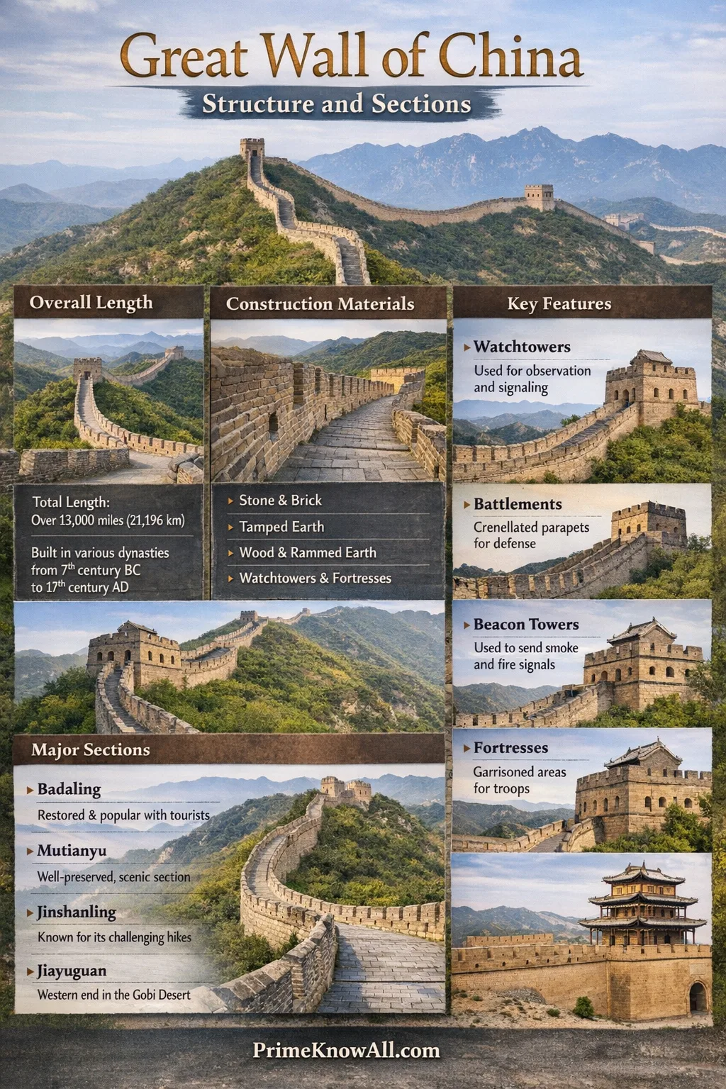
The Great Wall of China is not one continuous ribbon of stone. It is a layered defensive landscape made of walls, passes, towers, trenches, and fortresses built and rebuilt across many centuries. What most people picture today—high crenellated ramparts with brickwork and frequent watchtowers—comes largely from the Ming-era system. Yet beyond the famous sections near Beijing, the Wall changes character dramatically: it becomes rammed earth on open plains, stone lines across ridges, and even ditches and berms in drylands where “a wall” is only one part of the barrier.
What The Great Wall Actually Is
“Great Wall” is best understood as a network rather than a single monument. Different dynasties and frontier states built their own segments, often in different places and for different tactical goals. Over time, these segments formed a broad belt of fortifications across northern China, tied together by passes, garrisons, and communication lines.
That is why the Great Wall includes more than standing masonry. In official surveys and heritage descriptions, the system can include walls, beacon towers, fortresses, passes, and other supporting structures. In some regions, the most effective barrier was a trench and embankment; in others it was a thick, elevated wall with a road-like top that moved soldiers and supplies quickly.
How A Wall Segment Is Put Together
Even in its most iconic form, the Wall is not just “a tall line.” A typical fortified stretch combines structure and behavior: it blocks movement, channels traffic toward controllable chokepoints, and creates a platform for observation and signaling. The design changes with terrain, but the same building logic repeats across many sections.
The Wall Body
The main wall (the rampart) is typically a layered core faced with local material. In mountainous areas, stone is common; near the capital region, brick becomes widespread. Many stretches have a flat top wide enough for patrols, carts, and rapid movement of troops. This “roof of the wall” matters as much as its height, because it turns a barrier into a transport corridor.
Parapets And Battlements
Most well-known Ming sections have crenellations—alternating solid merlons and open gaps—along one or both sides. The outer parapet focuses on defense, while the inner parapet can support safe movement on narrow ridgelines. These features are not decorative; they control sightlines, provide cover, and define firing positions for defenders.
Watchtowers, Flanking Towers, And Platforms
Towers are the Wall’s decision points. A tower is where guards see farther, store supplies, shelter from weather, and coordinate movement. Flanking towers appear at intervals to cover blind spots and increase the range of observation along the line. In many places, tower spacing reflects the logic of visibility: each position needs to see the next, especially where signaling is part of the system.
Beacon Towers And Signaling Lines
Beyond the wall itself, many areas used beacon towers on high ground to relay warnings using smoke by day and fire by night. This creates a fast, low-tech communication network across enormous distances. The key engineering idea is line-of-sight: tower placement often prioritizes ridge crests and isolated hills, even when that means the “wall” must bend, climb, or split into parallel lines.
Passes And Gate Fortresses
Passes are where the Great Wall becomes a controlled interface rather than a barrier. Instead of blocking everything, a pass funnels movement through gates, courtyards, and layered defenses. Famous nodes like Shanhaiguan in the east and Jiayuguan in the west are not just “doors in a wall.” They are compact military towns built to manage traffic, collect duties, and respond quickly to threats.
Fortresses, Barracks, And Supply Logic
A long wall is only as strong as its logistics. Many segments are supported by nearby forts, barracks, armories, stables, and storage areas. The most sophisticated systems treat the Wall like a spine, with side structures that feed defenders with food, water, weapons, and reinforcements. In rugged terrain, the placement of these support points often follows water access as much as it follows tactical lines.
Materials And Construction Methods
The Great Wall is a masterclass in local-material engineering. Builders used what the landscape provided, and that is why different regions look and age differently. The “same” Wall can be brick and stone near Beijing, then become tamped earth across open country, and later shift into mixed layers of gravel, reeds, and compacted soil in arid zones.
Rammed Earth And Layered Fill
Many early and inland segments rely on rammed earth, a technique that compresses soil in layers within temporary formwork. When done well, the result can be extremely dense and durable. In dry climates, compacted earth can survive for long periods, but it is more vulnerable to erosion from wind and sudden rain, especially when vegetation cover is lost.
Stone Foundations And Mountain Masonry
In mountainous regions, stone is often the rational choice: it resists weather, supports steep grades, and can be shaped into stable foundations. Some ridge-top sections are essentially stone-built retaining structures that create a level path over uneven ground. The engineering challenge here is not only stacking stone, but controlling drainage so water does not undermine the base.

Brick Facing And Ming-Era Standardization
Brick becomes a defining material in many of the best-preserved sections associated with the Ming period. Bricks are more uniform than fieldstone, making it easier to build straight parapets, crisp battlements, and consistent platforms. Where brick is used as a facing over a packed core, the wall gains strength and a cleaner geometry, which helps with both defense and maintenance.
A Useful Way To Picture It
In many places, the Great Wall is a platform first and a barrier second. The top surface enables patrols and supply movement, while towers and passes turn that movement into a coordinated system.
How “Sections” Are Defined
When people talk about Wall “sections,” they might mean one of three things: a tourist-accessible stretch (like Badaling), a regional chain of fortifications (like the walls in Gansu), or a historical construction program (like the Ming Great Wall). These definitions overlap, which is why maps can disagree while still being correct in their own terms.
A practical way to categorize sections is by function and terrain. Mountain walls prioritize observation and control of passes. Plains walls aim to slow movement and create predictable crossing points. Desert-edge walls often pair with beacon towers and fortresses, where the priority is early warning and supply control rather than continuous masonry.
A Few Numbers That Help Frame The Scale
The Great Wall’s measured total length across all included elements is commonly cited at about 21,196 kilometers (including overlapping and rebuilt stretches). The most recognizable masonry-heavy system from the Ming period is often described as roughly 8,850 kilometers in length. These figures are best treated as system measurements, not the length of a single walkable wall.
Major Sections People Recognize Today
Some sections are famous because they are restored and accessible. Others are famous because they are unrestored and show the Wall’s raw interaction with weather and time. Together, they reveal how the same design language—rampart, towers, passes—adapts to wildly different landscapes.
Beijing Area Sections
Near Beijing, the Wall is often at its most architecturally crisp: brick-facing, strong parapets, frequent towers, and carefully engineered stair grades over ridges. These stretches are also where the Wall served as a high-priority defensive belt close to political and population centers, so reinforcement and repair were historically more intensive.
- Badaling – Known for heavy restoration, wide walkways, and a clear view of how parapets and towers repeat in a standardized pattern.
- Mutianyu – Noted for a densely towered ridge line and a well-preserved feel while still being restored.
- Juyongguan – A pass-focused experience where the key story is the gate fortress logic rather than long continuous walking.
Hebei And The Mountain Ridge Line Sections
Moving into Hebei’s mountainous areas, the Wall becomes a study in topographic negotiation. Towers sit on peaks and saddles, and the wall line bends to keep visibility between posts. Here, the Wall looks less like a straight boundary and more like a chain of connected high points.
- Jinshanling – A mix of restored and less-restored stretches that makes the tower spacing and ridge strategy easy to read.
- Simatai – Known for steep gradients and dramatic tower placement, showing how the Wall can function as a mountain route as much as a barrier.
- Gubeikou – Often discussed for a more rugged feel and historical layering that hints at how sections were rebuilt over time.
“Wild Wall” Stretches And Unrestored Character
Some sections are left closer to their weathered state, which reveals the Wall’s structural vulnerabilities. Brick facing can fall away, cores can slump, and stair treads become uneven. While these places can be visually striking, they also show an important point: maintenance is not cosmetic. Without it, even dense masonry can slowly lose its load paths and stability.
Myth Check: The Great Wall is often said to be visible from space with the naked eye. In practice, it is usually not easily visible without aid because many materials blend into surrounding terrain, and the wall is relatively narrow compared to the scale of Earth’s surface.
Sections By Geography: From Sea To Desert
Another useful lens is the Wall’s east-to-west shift. The environment changes from coastal plains to steep mountains to arid corridors. The Wall responds by changing materials, thickness, and how often it relies on nodes (passes and forts) instead of continuous height.
The Eastern End And Coastal Interface
The Wall’s eastern end is often associated with Shanhaiguan, a strategically famous pass area near where the defensive line meets the coastal region. In this setting, the Wall works as a gateway system—controlling movement between inland routes and coastal corridors, with fortifications that emphasize layered entry control over sheer height.
The North China Mountains: Visibility And Chokepoints
In the mountains, the key resource is elevation. Walls and towers align to dominate ridgelines, watch valleys, and guard saddle passes. Stair-like climbs, sharp turns, and frequent towers are not design quirks; they are responses to terrain constraints and the need to keep defenders connected across peaks.
The Drylands And Corridor Strategy In The West
Farther west, long distances, sparse water, and open horizons change the problem. Continuous high walls are harder to maintain, so the system leans more heavily on fortresses, beacon towers, and controlled routes. Places like Jiayuguan are remembered as powerful nodes, reinforcing the idea that in the west the Wall often functions as a network of strongpoints rather than a single unbroken barrier.
Comparison Table: Well-Known Sections And What They Show
This table focuses on what each section reveals about structure and design choices, not on travel logistics. Names can represent broader areas, but each entry points to a distinct “reading” of how the Wall works.
| Section / Area | Landscape Type | Typical Look | What It Teaches About The Wall |
|---|---|---|---|
| Badaling | Mountain ridges | Highly restored brick ramparts, clear battlements | Standardized Ming geometry and how towers repeat as a system |
| Mutianyu | Forested hills | Dense watchtower spacing, strong parapets | Visibility logic and why tower intervals matter for coordination |
| Jinshanling | High ridgelines | Mixed restoration, strong ridge alignment | Terrain-driven alignment and how the Wall bends to keep sightlines |
| Simatai | Steep mountains | Dramatic climbs, tight turns, prominent towers | Structural adaptation to steep grades and ridge chokepoints |
| Shanhaiguan | Pass and coastal interface | Fortified gateway character | Pass-first thinking: control and layering over continuous height |
| Jiayuguan | Arid corridor edge | Fortress node associated with western routes | Strongpoint network logic where supply and control are more important than length |
How To “Read” A Great Wall Segment Like An Engineer
Two adjacent sections can look similar and still be built for different reasons. A useful approach is to read each segment through constraints and choices: what the terrain forced, what materials allowed, and what the defense system needed at that point.
- Start with the ridgeline: Does the wall ride the highest crest, or does it dip to protect a valley route?
- Track tower-to-tower sightlines: Can one tower plausibly see the next? If not, look for beacon high points nearby.
- Check the top width: A broader top suggests the wall is also a movement platform for patrols and supply.
- Look for drainage solutions: Where does water go after storms? Stable sections usually manage runoff rather than fighting it.
- Find the nearest pass or gate logic: If a segment funnels toward a gap, the “real” defense might be the pass complex.
Preservation Differences: Why Some Parts Survive Better
Condition depends on material, climate, and human activity. Brick and stone generally resist weathering better than exposed earth cores, but even masonry fails if water penetrates, freezes, and pries joints open. In arid zones, earth walls can survive for long periods, yet they are vulnerable to wind scouring and sudden downpours that carve channels into exposed faces.
Another factor is proximity to population and maintenance resources. Many famous sections near major cities benefit from restoration and protective policies. More remote stretches, especially those built with compacted soil, can lose height gradually as the outer surface erodes. Over decades, that slow change can shift a wall from a sharp-edged barrier to a low, rounded berm that is still historically meaningful even if it looks less dramatic.
Small Detail, Big Impact
Where the facing survives, the wall looks “intact.” Where the facing is gone, the core may still be present but exposed. That exposure accelerates weathering and makes the original geometry harder to recognize.
Sources
- UNESCO World Heritage Centre – The Great Wall [Official heritage description and how the property is defined as a defensive system]
- Encyclopaedia Britannica – Great Wall of China [Clear overview with widely cited figures and historical framing]
- Wikipedia – Great Wall of China [Helpful starting map and terminology for towers, passes, and construction materials]
- UNESCO World Heritage Centre – Great Wall Documentation [Background materials connected to the listing and conservation context]
FAQ
Is the Great Wall one continuous wall from end to end?
No. The term refers to a network of fortifications built in different periods. In some places the system is a high masonry wall; elsewhere it is a trench, an embankment, beacon towers, or a pass fortress that does most of the defensive work.
Which parts are mostly Ming-era construction?
Many of the most recognizable brick-and-stone ramparts with frequent towers are associated with the Ming defensive system. Earlier walls often rely more on rammed earth and local stone, and they can appear less uniform because construction methods and priorities varied widely.
Why do some sections look sharp and tall while others look like low ridges?
Survival depends on materials, climate, and maintenance. Brick and stone hold shape longer, while exposed earth cores can erode into rounded forms. A section can still be historically authentic even when the original height is reduced.
What are the most important structural elements besides the wall itself?
The system relies heavily on watchtowers, beacon towers, and passes. Towers create observation and coordination points, while passes turn the Wall into a controlled boundary where movement can be managed rather than simply blocked.
Can the Great Wall be seen from space with the naked eye?
Usually, no. Although the Wall is long, it is relatively narrow and often matches the color and texture of surrounding landscapes. From orbit, visibility depends on lighting, atmospheric clarity, and camera magnification, not on the wall being inherently obvious.