In One Clear View: Carthage was not just a wealthy port. It was a carefully arranged urban machine where terrain, harbors, walls, storage, water systems, and ship handling worked together. That is why its urban design and military design are best understood as the same story.
Carthage turned geography into architecture. Set on a promontory above the Gulf of Tunis, with the Byrsa height behind it, a narrow land approach, and sheltered water to the south, the city was placed where trade routes and defense lines met. That choice shaped almost everything that followed, from its harbors and walls to its street pattern and water storage.
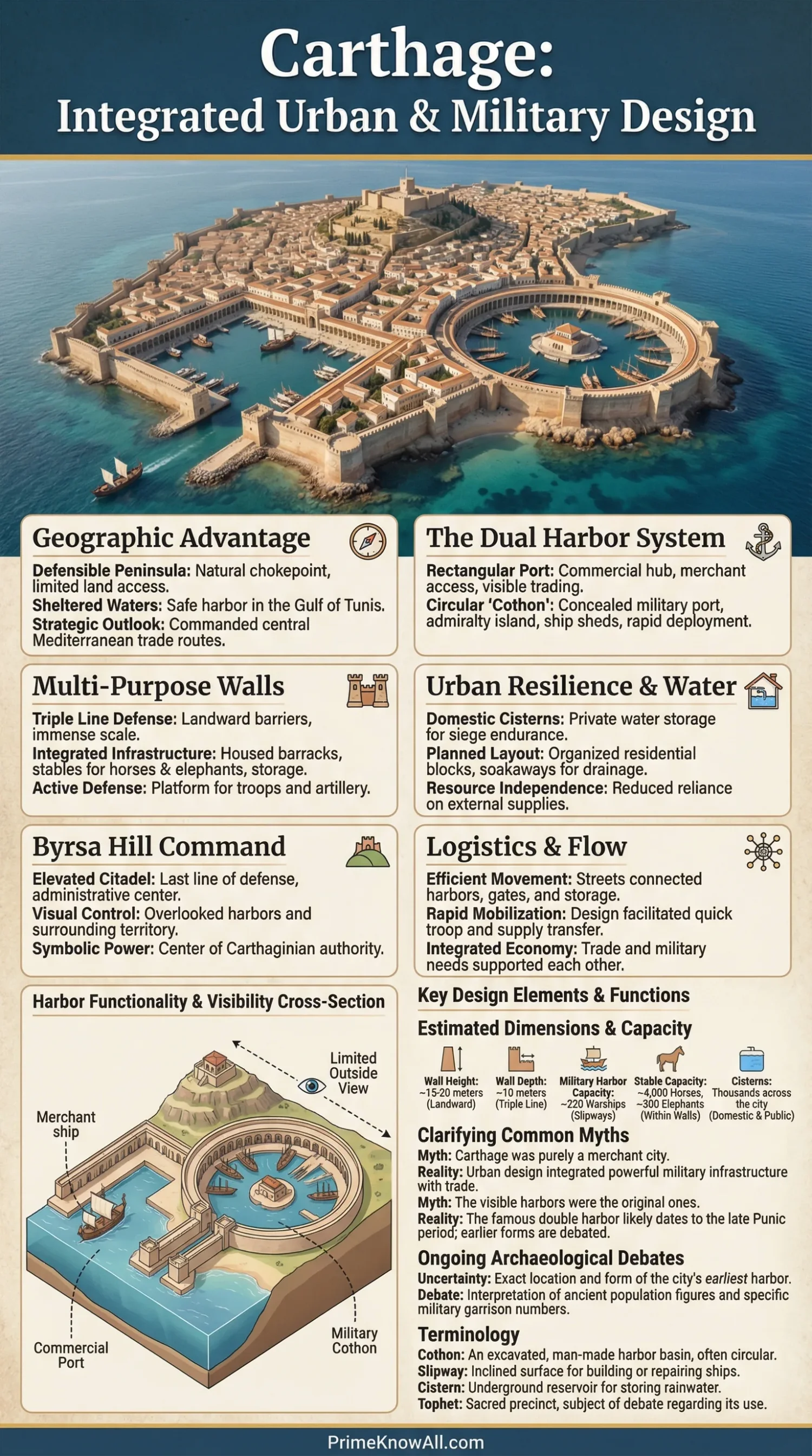
Urban design in Carthage was never only about comfort, and military design was never only about battle. Houses used cisterns, neighborhoods linked to gates and shoreline works, and the port zone blended warehousing, repair space, loading areas, and controlled access. Even the best-known harbor remains make more sense when seen as part of a citywide logistics system, not a single isolated wonder.
If you remember one thing: Carthage was strong because it fused commerce, mobility, storage, surveillance, and defense into one urban layout. That fusion made the city harder to starve, harder to surprise, and harder to replace.
What To Keep In Mind
- Carthage sat at a maritime chokepoint, close to the movement corridor between Sicily and North Africa.
- The famous double harbor mattered, but it was only one part of a wider urban system.
- Byrsa Hill gave the city a defensible high point and visual command over the surrounding zone.
- Ancient descriptions of the walls are useful, but some numbers should be read with care, not blind literalism.
- Excavated housing shows a city with planned residential blocks, courtyards, cisterns, and some very large homes.
- Archaeology still leaves open a few hard questions, especially about the earliest harbor and how some ritual spaces should be interpreted.
Why The Site Gave Carthage an Edge
Carthage began with location. The city stood on a coastal projection that could watch sea traffic, use sheltered water, and reduce the number of easy land approaches. That is the first design decision to understand: before walls, before dockyards, before famous generals, the landscape was already doing defensive work.
Ancient description places the city in a recess of a large gulf, cut from the mainland by an isthmus about 5 kilometers wide, with a narrower strip running between lake and sea. That meant attackers could not simply treat Carthage like an open inland capital. They had to deal with water, limited approaches, elevated ground, and harbor infrastructure that could still move people and supplies under pressure.
- Sea lanes: Carthage could watch movement across the central Mediterranean and react fast.
- Sheltered water: The nearby lagoon and harbor area lowered everyday operating risk for shipping.
- High ground: Byrsa worked as a commanding urban anchor, not just a symbolic center.
- Controlled land access: A narrower landward approach made fortification more efficient.
How The City, Shoreline, and Harbors Formed One System
Carthage did not separate urban life from naval life. Its shoreline, port basins, gates, ramparts, storage zones, and residential quarters interacted constantly. A merchant arrival, a military refit, a water shortage, and an emergency muster all touched the same urban fabric. That is why urban planning and strategic planning should be read together here.
| Design Element | Urban Job | Wartime Job | What It Reveals |
|---|---|---|---|
| Byrsa Hill | Administrative and symbolic center | Fallback high ground and lookout point | Power and defense shared the same elevated core |
| Rectangular Harbor | Goods handling, docking, circulation | Supply intake and controlled access | Trade space could support war logistics |
| Circular Harbor and Island | Repair, organization, command visibility | Naval readiness and fleet control | Ship management was built into the city plan |
| Landward Walls | Urban boundary and movement control | Primary land defense and troop housing | Fortification doubled as military infrastructure |
| Courtyard Houses With Cisterns | Water storage and domestic life | Resilience during stress or siege | Private architecture helped public survival |
| Street Network Near Gates and Shore | Movement of people and goods | Fast redistribution of labor and supplies | Circulation was a strategic asset |
How Carthage Worked From Top To Bottom
A vertical reading of the city shows how height, harbor space, and housing all fed the same operating logic.
1. Byrsa Hill: elevated command point, urban anchor, last defensive refuge.
2. Upper City Routes: streets linked hill, neighborhoods, and access lines to the port zone.
3. Residential Blocks: courtyard houses, cisterns, soakaways, workshops, and family compounds created urban staying power.
4. Gate and Rampart Zone: walls did more than block entry; they housed animals, troops, and supplies in ancient description.
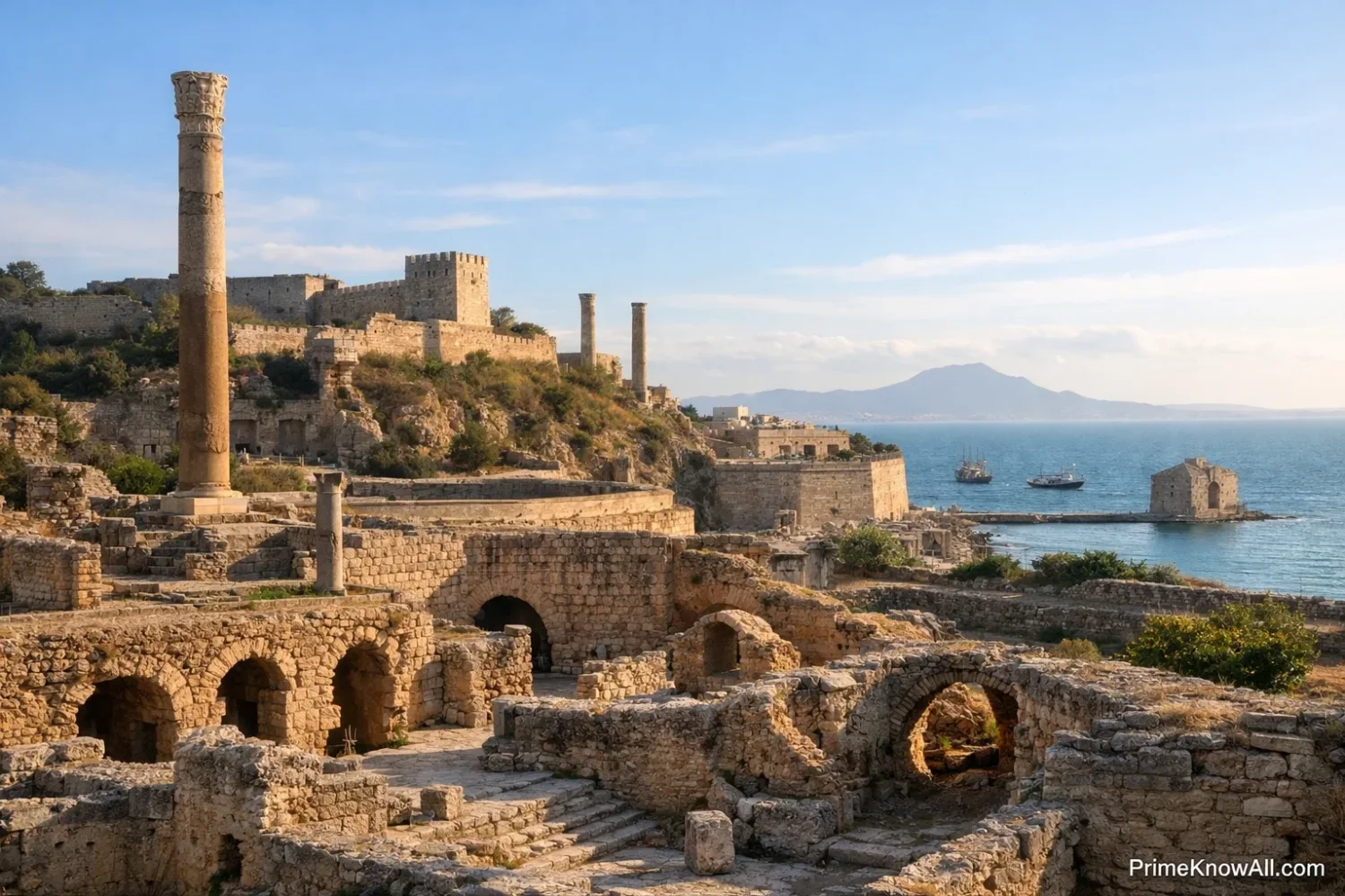
5. Rectangular Harbor: commercial intake, cargo handling, and connection toward the city.
6. Circular Harbor: concentrated naval organization with an inner island for oversight and ship arrangements.
7. Outer Shoreline: vulnerable edge, working edge, and the point where natural change could help or hurt the city over time.
Pause Here
- Carthage functioned as a linked system, not as a set of isolated monuments.
- The city’s port zone only makes full sense when read alongside its walls, hill, and housing.
- Landscape was not background. It was part of the design.
What The Double Harbor Did in Practice
The double harbor gave Carthage flexibility. One basin handled mercantile movement more openly, while the other concentrated naval management in a more controlled environment. Ancient writers noticed the separation, and archaeology supports the broad distinction, even if some details remain debated.
The Rectangular Basin
The outer, more rectangular basin is usually linked to commercial use. That makes practical sense. Merchants needed access, unloading space, nearby storage, and a route into the city that did not expose the whole naval setup. Ancient description says incoming merchants could not easily see the dockyards, and that mattered. Controlled visibility was a design choice.
- Likely roles: cargo movement, warehousing, loading, and customs-like control.
- Urban effect: it brought wealth into the city without giving outsiders a full view of protected military space.
- Military effect: it allowed supply movement even when defense needed tighter separation.
The Circular Basin and The Admiralty Island
The inner circular basin is the part that fixed itself in historical memory. Ancient description places an island near the entrance, rising high enough for the admiral to watch the sea while outsiders could not clearly see inside. That is a smart piece of military urbanism. Command, concealment, and ship handling came together in one engineered space.
Archaeological work on the late Punic port zone suggests the inland harbor complex occupied an area of about 1 kilometer north to south and roughly 300 meters east to west. The same research also notes that the harbor zone sat on naturally low coastal ground, around 2–3 meters above present sea level, and that the shoreline has shifted over time. In plain terms, Carthage was building naval power in a landscape that was useful, but never static.
What Needs Care In Modern Retellings
The most common simplification is this: people treat the visible circular and rectangular basins as if they tell the entire story of Carthage’s harbor history. They do not. Archaeologists have been clear for years that the earliest harbor is still uncertain, and the famous surviving arrangement is best tied to the later Punic phase, especially the city’s last century or so before 146 BCE.
That matters because it changes the question. Instead of asking only, “How many ships fit there?”, a better question is, “When did this harbor form take shape, and what urban needs did it answer at that stage?” That shift makes the city look less like a frozen legend and more like a place that kept redesigning itself.
How Fortifications Worked Beyond Simple Defense
Carthage’s walls were not just barriers. In ancient description, they were defensive architecture mixed with storage and troop support. That idea is easy to miss because later summaries often reduce the city to “big walls” and stop there. The more useful view is that fortification also helped organize animals, soldiers, equipment, and movement.
Appian describes the landward side near the isthmus as having a triple wall, each about 15 meters high and 10 meters deep, with towers spaced every 60 meters. He also says the lower vaulted spaces included room for 300 elephants, with higher levels for 4,000 horses, and barracks for 20,000 infantry and 4,000 cavalry. Those figures are ancient-source numbers and should be read with caution, but the design idea is still striking: the wall line itself was imagined as an operating zone, not only a facade.
- Defense: resist direct land assault along the easiest approach.
- Concentration: keep military resources close to the most threatened front.
- Mobility: allow fast reinforcement without scattering forces across the city.
- Psychology: project order, capacity, and readiness to enemies and residents alike.
A second detail matters just as much. Appian notes one weaker, lower section near the harbor side. That is a reminder that cities are never perfectly even. Carthage was not protected by abstract geometry. It had strong zones, compromised zones, and zones that had been neglected or altered over time. Real urban defense is always uneven.
What This Section Adds
- The walls were described as multi-use infrastructure, not just masonry.
- A city built for war still had weak seams; that is often where sieges turn.
- Ancient numbers help, but they should be balanced with archaeology and common sense.
What Homes, Streets, and Water Storage Reveal
Urban design becomes more human at house level. Excavated parts of the Magon Quarter show a residential district that changed over time, with later rebuilding producing larger, more decorated homes. This matters because it proves Carthage was not simply a port full of sheds and barracks. It was a dense, planned, and socially layered city.
Official Tunisian heritage material describes early dwellings in this quarter as more modest, then notes a later phase in which large houses appeared, some with floor areas of more than 1,000 square meters and reaching around 1,500 square meters. These homes had multiple underground cisterns, painted and stuccoed surfaces, courtyards, and access through narrow corridors. Streets, by contrast, are described as unpaved and without drains, while each house used an underground soakaway.
A cistern, a tank built below or beside a house to store water, mattered in Carthage because siege risk and seasonal pressure rewarded households that could hold their own reserves. A soakaway, a buried chamber that let wastewater drain into the ground, helped private homes cope even where public street drainage was limited. Those two elements say a lot. Resilience in Carthage was partly domestic.
- Courtyard house: a home organized around an inner open space that improves light, air, privacy, and circulation.
- Cistern: a built reservoir for stored water, often essential in cities under pressure.
- Slipway: a sloped surface where a ship can be pulled from the water for repair or storage.
- Cothon: a harbor basin shaped or enclosed by human construction; in Carthage, the term is often used for the famous port complex.
One good analogy helps here. Carthage worked a bit like a modern airport-city hybrid: there was a high-control movement zone, a service zone, a storage zone, housing that depended on those flows, and a security logic built into circulation. That does not mean ancient harbors were modern terminals. It means the city’s real strength lay in how movement, repair, storage, and control were all planned together.
Where Civilian Design and Military Design Met
The usual split between “civilian city” and “military city” breaks down at Carthage. Its design suggests a place where everyday prosperity helped pay for naval readiness, and naval readiness helped protect prosperity. This overlap is one of the most useful ways to understand the city without falling into heroic myth.
- Harbor separation helped protect military knowledge while keeping commerce active.
- Private water storage improved household life and also made the city harder to break under pressure.
- Large houses and compounds imply wealth, but also storage capacity and family labor depth.
- Gate-linked streets helped ordinary movement and emergency mobilization alike.
- Shoreline works served loading, repair, and defense at the same time.
- Hilltop command space was urban prestige with clear tactical value.
Common Misconceptions About Carthage
- Wrong: Carthage was mainly a merchant city.
Correct: It was a merchant-naval city whose wealth and defense reinforced each other.
Why It Gets Missed: Many summaries separate trade history from military history as if the two never overlapped. - Wrong: The circular harbor explains the whole city.
Correct: The harbor is famous, but Byrsa, walls, streets, and housing are just as important to the city’s design logic.
Why It Gets Missed: The circular basin is visually memorable, so it gets more attention than less dramatic features. - Wrong: The visible double harbor must be the city’s original harbor setup.
Correct: Scholars still debate the earliest harbor location; the famous preserved arrangement belongs to a later Punic stage.
Why It Gets Missed: Readers often treat what survives best as what came first. - Wrong: Carthaginian housing was plain and improvised.
Correct: Excavated quarters show planned compounds, decorated interiors, courtyards, and major water storage.
Why It Gets Missed: Popular retellings focus on ships and generals, not neighborhoods. - Wrong: Ancient figures for walls and military capacity can be copied straight into modern prose without caution.
Correct: Ancient descriptions are valuable, but some numbers should be treated as part observation, part rhetorical scaling.
Why It Gets Missed: Round numbers sound neat, and neat numbers travel well online. - Wrong: The Tophet is a fully settled topic.
Correct: The site remains heavily debated in scholarship, especially around infant burial and sacrifice questions.
Why It Gets Missed: Simple headlines spread faster than unresolved evidence.
Small Checkpoint
- Trade and defense were braided together in Carthage.
- The city changed over time; it was not a single frozen design.
- Some of the most revealing evidence comes from houses, water systems, and port-edge archaeology, not only from war stories.
Everyday Scenes That Make The Design Easier To See
- A merchant ship arrives after bad weather. It needs sheltered entry, unloading space, and quick access to the city. That is why a protected commercial basin matters.
- A naval crew needs repairs without public exposure. A more restricted harbor zone keeps ship work organized and less visible. That is why separation inside the port matters.
- A household faces water stress. Private cisterns soften the blow and reduce dependence on a single public source. That is why domestic design matters in state resilience.
- An attacking army chooses the easiest land approach. The city concentrates its strongest landward defenses where terrain allows direct pressure. That is why wall placement matters more than wall length alone.
- A commander needs to monitor incoming movement. Height and controlled sightlines are worth almost as much as raw masonry. That is why Byrsa and the harbor island matter together.
- A city must keep working during panic. Workshops, streets, gates, and storage zones need to stay functional under stress. That is why urban order is also military order.
- A shoreline slowly changes over generations. Silting, erosion, and shifting coastal conditions force redesign. That is why Carthage’s harbor story is a history of adaptation, not one fixed blueprint.
What We Still Do Not Know for Sure
Good history leaves room for uncertainty. Carthage is famous, but fame can hide how much of the city still has to be reconstructed from partial remains, ancient texts written after the fact, and areas buried beneath later occupation. A careful reading should hold both clarity and limits at the same time.
- The earliest harbor: late Punic harbor archaeology is clearer than the city’s first harbor arrangement.
- Ancient wall figures: Appian preserves useful numbers, but those numbers do not automatically equal field-measured engineering data.
- The Tophet debate: scholarship remains divided on how all the evidence should be interpreted.
- Full urban spread by period: some quarters are better known than others, and later Roman building over earlier layers complicates the picture.
Limits of this explanation: this article focuses on the Punic city’s urban and military logic. It does not try to settle every dating dispute, list every excavation trench, or turn uncertain figures into hard certainties. That restraint is deliberate. Precision is better than false confidence.
Why Carthage Still Matters Right Now
Carthage is not only a dead city in books. It is a living heritage landscape inside a modern urban setting, and that tension affects how the past is protected and studied. UNESCO’s 2025 committee decision on the site still points to illegal construction concerns, slow-moving protection plans, and the need for stronger management coordination around the property. In other words, the modern problem is strangely close to the ancient one: how do you protect a strategic place under pressure?
There is also a more hopeful angle. New digital work tied to the ASOR Punic Project is using 3D modeling and archival recovery to put Carthaginian stelae and spatial relationships back into context. That kind of work matters because Carthage is not one intact ruin. It is a fragmented site, and better spatial reconstruction can change how readers understand the whole city.
Quick Test
A city has one basin for merchants and a more protected inner basin for warships. What problem is that layout solving?
It separates commercial openness from military control. Merchants can enter, unload, and connect with the urban market without freely observing naval operations. The protected basin also helps commanders organize repair, storage, and readiness in a space that is easier to monitor. In Carthage, this was not a decorative plan. It reduced risk while keeping trade alive.
Why would households with cisterns matter during a siege?
Water independence at house level lowers strain on the city as a whole. If many homes store usable water, daily life can keep functioning longer under pressure. That does not remove the danger of siege, but it improves staying power. In Carthage, domestic architecture helped urban endurance.
If the walls housed animals and troops in ancient description, what does that say about military design?
It shows that fortification was imagined as active infrastructure, not only a blocking edge. The wall line could support mobilization, supply, and rapid concentration of force. Even if the ancient figures are not copied too literally, the design idea is still clear. Carthage treated defense as a working system built into the city itself.
Why does the uncertain location of the earliest harbor matter so much?
Because it changes how the city’s growth is explained. If the harbor system changed over time, then Carthage evolved instead of appearing fully formed. That means urban design followed new pressures, new coastlines, and new political needs. It also warns against treating the best-known harbor remains as the only harbor story.
What is the most useful way to picture Byrsa Hill in the city plan?
Think of Byrsa as both a symbolic center and a tactical advantage. High ground improves oversight, strengthens fallback defense, and gives a city a clear internal anchor. In Carthage, hilltop placement was never merely ceremonial. It supported urban hierarchy and military observation at the same time.
Sources
- UNESCO World Heritage Centre – Archaeological Site of Carthage — Useful for the site’s official heritage description, location, and long-term historical importance. Why reliable? It is the formal World Heritage record for the site and reflects institutional documentation standards.
- UNESCO World Heritage Centre – Decision 47 COM 7B.180 — Useful for the current conservation picture, including management delays and illegal construction concerns around the property. Why reliable? It is a formal UNESCO committee decision published as part of the World Heritage process.
- Encyclopaedia Britannica – Carthage: History, Location, and Facts — Useful for the city’s geographical setting and its place in Mediterranean trade and politics. Why reliable? Britannica is a long-established reference work edited by subject specialists.
- Livius – Appian, The Punic Wars 19 — Useful for the ancient description of the landward walls, dimensions, and military facilities attached to them. Why reliable? It provides a stable scholarly translation of a primary classical source with editorial notes.
- Livius – Appian, The Punic Wars 20 — Useful for the ancient description of the harbor island, visibility control, and separation between merchants and dockyards. Why reliable? It is a curated presentation of a primary source central to late Punic Carthage.
- Henry Hurst and Lawrence E. Stager – A Metropolitan Landscape: The Late Punic Port of Carthage — Useful for archaeological discussion of the late Punic harbor zone, coastal change, and the warning that the original harbor remains uncertain. Why reliable? It is a scholarly article grounded in excavation work and still widely cited in harbor studies.
- Agency for the Development of Heritage and Cultural Promotion, Tunisia – The Magon Quarter — Useful for excavated domestic architecture, house size, cisterns, courtyards, and street details. Why reliable? It is an official Tunisian heritage presentation tied to the site itself.
- Antiquity / Cambridge University Press – Cemetery or Sacrifice? Infant Burials at the Carthage Tophet — Useful for showing that the Tophet remains a debated issue rather than a settled one-liner. Why reliable? It is peer-reviewed scholarship from a major academic publisher.
- The Ancient Near East Today – Putting Carthaginian Stelae Back Into Context — Useful for current digital work reconstructing spatial context in Carthage. Why reliable? It is written by a project scholar and linked to ongoing research activity in the field.
FAQ
Was Carthage planned more for trade or for war?
Both. The city’s design suggests a place where commercial efficiency and military readiness supported one another. The harbor system, wall lines, and water storage all fit that mixed purpose.
What was the Byrsa in Carthage?
Byrsa was the city’s high ground and major urban anchor. It carried political and symbolic weight, but it also had obvious defensive value because height improves oversight and last-resort defense.
Did the famous circular harbor exist from the start of the city?
Not securely. The preserved double-harbor arrangement is usually tied to the later Punic city, while the earliest harbor setup remains debated in archaeology.
How strong were Carthage’s walls?
Ancient description presents the landward walls as very powerful and deeply organized, with multiple lines and support spaces. Those details are valuable, but the exact figures should be used with caution and balanced against archaeology.
What do excavated houses tell us about Carthage?
They show a city with planned residential life, courtyards, decorated interiors, underground cisterns, and some very large compounds. Carthage was not only a port of fleets; it was a highly organized urban community.
Why is Carthage still important today?
It remains a major heritage site and a test case for how to protect archaeology inside a modern urban environment. New digital work is also helping scholars rebuild the city’s fragmented spatial history.
Carthage makes the most sense when it is read as a designed system, not a loose collection of ruins. Its hill, harbors, fortifications, housing, and water storage formed one urban logic, and that logic helps explain why the city mattered for so long. The most common mistake is to reduce Carthage to either a trader’s port or a war state, when its real strength came from joining the two. The rule worth keeping is simple: when a city’s daily layout can also support emergency action, that city is much harder to break.