Roman military camps used a repeated plan so soldiers could build, defend, and read the site fast. A standard camp usually included four gates, straight internal roads, a central command area, ordered spaces for units, and a clear strip between the tents and the rampart. The outline was often rectangular with rounded corners, yet the Romans were practical enough to bend the pattern when the ground forced them to.
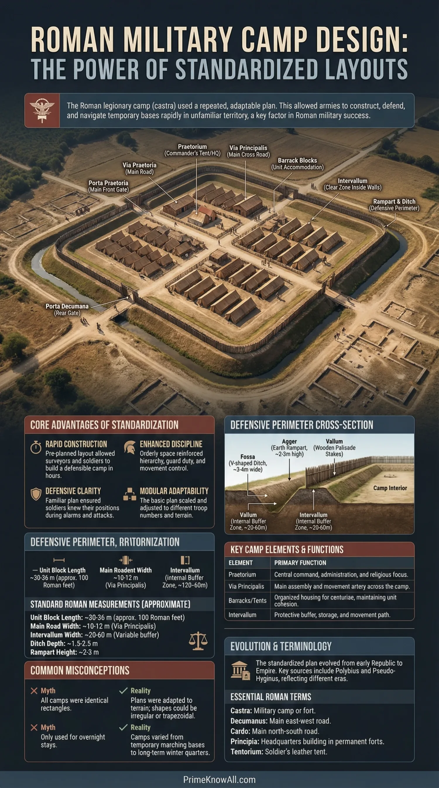
That mix of repetition and flexibility helps explain why Roman armies could stop in unfamiliar territory and still create an organized camp that felt immediately usable. Ancient writers such as Polybius and Pseudo-Hyginus describe ideal plans in measured units, while archaeology shows what happened when those ideals met rivers, ridges, crags, and campaign pressure.
If you remember one thing, remember this: standardized design was not about making every camp look identical. It was about making every camp legible, defensible, and fast to use for the people inside it.
What To Notice First
- Standardization saved time. A familiar plan meant fewer decisions at the end of a long march.
- It reduced confusion. Roads, gates, and unit areas followed a logic soldiers could learn and repeat.
- It helped discipline. Ordered space made guard duty, supply control, and command easier.
- It was modular. The same planning idea could scale up, down, or shift shape.
- Archaeology backs the texts. Rounded corners, defended gates, and repeated street patterns appear across many sites.
What Standardized Design Meant In A Roman Camp
Standardized design meant a camp was planned from a known template, not improvised from scratch every night. The Romans did not simply stop and scatter tents. They measured space, marked a command point, set roads, assigned unit zones, and added defenses in an order that turned a temporary stop into a controlled military environment.
Polybius says the Romans used “one simple plan” for camp layout and kept unit positions so consistent that soldiers knew where to go almost by habit. That matters more than the neat diagram alone. The plan was a memory tool as much as a fortification. A tired soldier entering camp at dusk did not need to learn a new map every time.
- Predictable gates helped movement and defense.
- Predictable roads helped orders travel.
- Predictable command space kept authority visible.
- Predictable unit blocks made assembly faster.
- Predictable empty zones improved safety inside the perimeter.
A Few Terms That Make Camp Plans Easier To Read
- Castra: the Latin term for a military camp or fortified base.
- Praetorium: in a marching camp, the commander’s central command zone; in later forts, the commander’s residence can also bear this name.
- Principia: the headquarters building in a more permanent fort.
- Intervallum: the open strip between the inner buildings or tents and the defenses.
- Via Praetoria: the main road leading toward the front gate.
- Via Principalis: the cross-road that linked the side gates.
- Titulum: a detached gate defense, usually a short ditch-and-bank obstacle in front of an entrance.
- Clavicula: a curved entrance arrangement that forced movement around a bend before entry.
What To Keep In Mind
- The Roman camp was planned space, not a random bivouac.
- The layout worked because soldiers could recognize it fast.
- Order itself was part of the defense.
Main Layout Elements And What They Did
The standard plan was a working machine made of repeated parts. Some parts handled command, some movement, some storage, and some defense. The same names appear again and again because the functions stayed familiar even when size or local form changed.
| Element | What It Was | Why It Mattered |
|---|---|---|
| Porta Praetoria | The front gate, often oriented toward the expected direction of action or enemy approach. | It gave the camp a tactical front and a clear axis. |
| Porta Decumana | The rear gate. | It supported movement, supply, and a stable rear orientation. |
| Via Praetoria | Main road running from the front gate inward. | It linked the entrance to command space and sped deployment. |
| Via Principalis | Main cross-road connecting the side gates. | It organized circulation across the whole camp. |
| Praetorium / Principia Zone | The command center of the camp or fort. | Orders, standards, pay, records, and ritual authority clustered here. |
| Barrack Or Tent Blocks | Ordered accommodation for infantry and cavalry units. | Known positions reduced confusion during alarms and marches. |
| Intervallum | An empty buffer inside the defenses. | It helped with movement, storage, and protection from missiles or fire. |
| Rampart And Ditch | The outer defensive line. | It turned a camp into a temporary fortress within hours or days. |
| Titulum / Clavicula | Gate defenses that complicated direct entry. | They slowed attackers and protected vulnerable openings. |
That combination of roads, gates, central command, and repeated unit zones is the real pattern. Rounded corners and a “playing-card” outline are memorable, but the stronger sign of Roman planning is the way the inside was ordered for movement and command.
- Marching camps emphasized speed and temporary shelter.
- Practice camps trained troops to reproduce the system.
- Construction camps served nearby building projects.
- Permanent forts and fortresses fixed the same logic in timber or stone.
What The Ancient Measurements Tell Us
The Roman texts do not just describe shape; they describe measurable space. That is one reason historians treat camp design as a real planning system rather than a vague habit. Polybius and Pseudo-Hyginus give dimensions for roads, buffers, and unit areas, which shows that measurement sat near the center of Roman military routine.
Polybius describes a camp in which the unit squares were set at 100 Roman feet in length, passages of 50 Roman feet appeared between major blocks, and the outer clear zone from tents to the agger reached 200 Roman feet. Using a Roman foot of about 0.296 meters, that works out to roughly 29.6 m, 14.8 m, and 59.2 m. Those are not decorative numbers. They show planning by module.
Pseudo-Hyginus gives an ideal camp ratio of 3:2, with an example of 2400 by 1600 Roman feet, or about 710 by 474 meters if that same foot value is used. He also gives figures for an intervallum of 60 feet, a via sagularis of 30 feet, and major roads such as the via praetoria and via principalis at 60 feet. The numbers vary by context, but the habit of assigning measured widths does not.
- 100 Roman feet is about 29.6 m.
- 200 Roman feet is about 59.2 m.
- 60 Roman feet is about 17.8 m.
- 30 Roman feet is about 8.9 m.
- 720 Roman feet is about 213.1 m.
A useful way to picture this: a Roman camp worked less like people “finding a place to sleep” and more like a pop-up operations base assembled from known measurements. The army was not camping in the casual sense. It was temporarily rebuilding its own ordered environment.
Before Moving On
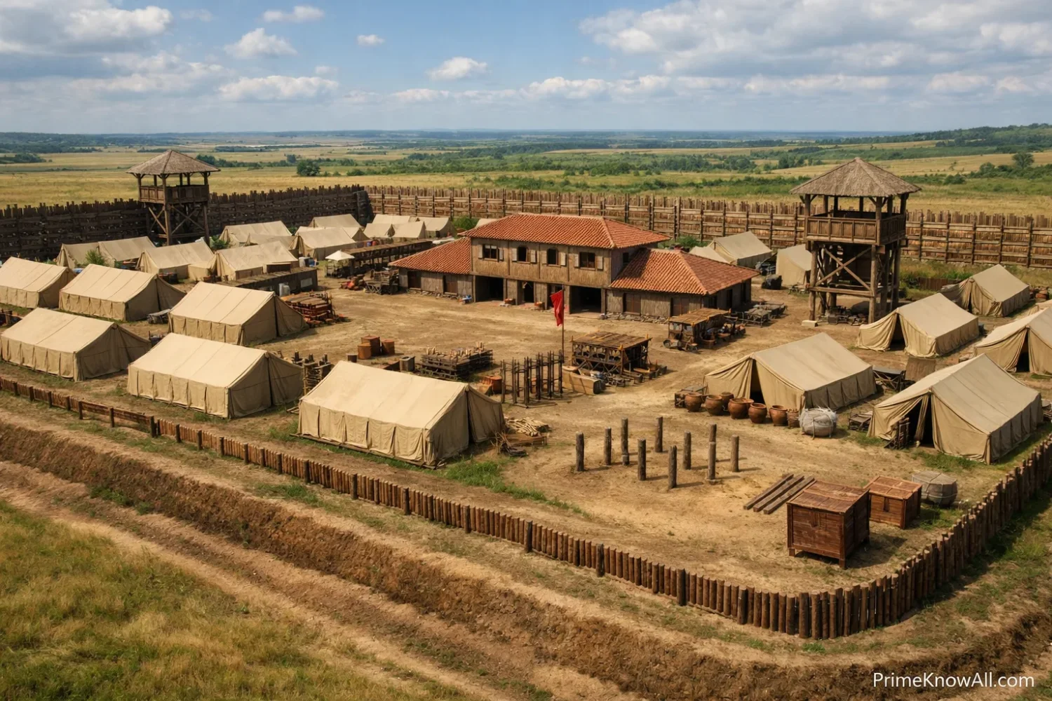
- The texts preserve real dimensions, not just names.
- Measured roads and buffers help explain Roman speed.
- Standardization was physical, not only conceptual.
Why The Romans Repeated The Plan
The repeated plan solved several battlefield problems at once. It made command easier, helped units find their place, supported night security, and reduced the chance that a tired army would lose cohesion after marching. The system was practical because it turned uncertainty outside the camp into predictability inside it.
Speed Was Part Of The Point
When a camp had familiar axes, gates, and unit zones, the surveyors and work parties were not inventing a fresh design every evening. That saved time in the phase when an army was most exposed: just after arrival, before defenses were finished.
- Surveyors could set the plan quickly.
- Work gangs knew where ditching and rampart lines belonged.
- Unit commanders knew where to lead their men.
- Messengers knew how to move through camp.
Discipline Was Built Into The Ground
Roman discipline was spatial as well as social. The plan put command at the center, lined up unit spaces, and used roads as visible order. A well-planned camp told every soldier where authority sat and where movement should flow.
Defense Was Easier When Everyone Knew The Map
A camp alarm is not the moment to ask where the side gate is. Polybius stresses that soldiers knew the location of their own place in camp almost as if they were returning to a known home street. That mental familiarity lowered confusion during darkness, noise, and stress.
- Guards could rotate without guesswork.
- Reinforcements could reach a gate faster.
- Supplies stayed easier to control.
- Loot, animals, and baggage could be kept in assigned zones.
How Fixed The Standard Really Was
The Roman plan was standard, but it was not rigid in a foolish way. Manuals describe ideal proportions. Archaeology shows adaptation. A camp could keep Roman logic while changing outline, gate count, or exact measurements because ground, weather, troop numbers, and local risk all mattered.
That is why a clean textbook rectangle should not be treated as the only “real” Roman camp. Some camps are close to the famous playing-card shape. Others bend to ridges, floodplains, roads, or rock. Historic England’s records show both neat examples and irregular ones shaped by local terrain.
- Rounded corners remained common because they protected weak angles.
- Gate arrangements could vary by date and function.
- Large camps might have more than four gates.
- Irregular ground could produce skewed or broken outlines.
- Repeated occupation could alter a camp over time.
What Changed And What Usually Stayed The Same
- Usually stayed the same: axial planning, command focus, defended entrances, ordered accommodation, internal hierarchy.
- Could change: total size, exact proportion, number of gates, local orientation, and how closely the outline matched a perfect rectangle.
This is one of the most useful corrections to the usual simplified story. Roman camps were standardized in method more than in exact outward appearance. The method is what traveled so well.
Polybius And Pseudo-Hyginus Are Not Describing The Same Army In The Same Way
One of the most common reading mistakes is to fuse Polybius and Pseudo-Hyginus into one timeless master plan. They are both useful, but they come from different military contexts. Polybius describes a Republican manipular army. Pseudo-Hyginus reflects a later imperial world built around cohorts and a more varied army.
That distinction matters because standardized design evolved. The idea of a measured, ordered camp remained. The exact arrangement of troop categories, the emphasis on certain roads, and the internal distribution of support units could shift. Treating every Roman camp plan as one frozen template flattens centuries of military change.
- Polybius is especially useful for the logic of repetition and unit order.
- Pseudo-Hyginus is especially useful for later technical terminology and dimensional planning.
- Archaeology tests both authors against what survives on the ground.
The Practical Pattern
- Polybius shows how repeated layout served a marching army.
- Pseudo-Hyginus shows later technical planning in more detail.
- The Roman camp was stable in principle, not frozen in one century’s form.
What Archaeology Shows On The Ground
Archaeology confirms the repeated pattern, but it also reveals variety, re-use, and local adaptation. This is where the neat diagram becomes a landscape problem. Some camps survive as earthworks. Many are now visible only as cropmarks, aerial traces, or subtle changes in terrain picked up by LiDAR.
Britain Is One Of The Best Laboratories For This Topic
Rebecca Jones noted that over 220 camps north of Hadrian’s Wall were known in Scotland at the time of her study, and that about 82% had been discovered by aerial archaeology. That alone says something powerful about Roman camps: many survive not as walls above ground, but as planned scars in the landscape.
- Practice camps can cluster near garrisons.
- Marching camps appear along routes of movement.
- Overlap and recutting show re-use across campaigns.
- Cropmarks often preserve outlines better than standing masonry does.
Permanent Forts Preserve The Internal Logic Very Clearly
Sites such as Vindolanda and Housesteads make the inner grammar of Roman planning easy to see. Headquarters, commander’s house, granaries, barracks, gates, and streets sit in a regular relationship. At Housesteads, English Heritage describes a fort interior arranged on a regular grid plan. At Vindolanda, the central principia, the praetorium, the horrea, and ordered barracks show the same logic in a frontier setting.
Recent Discoveries Keep Expanding The Map
This subject is still active archaeology, not a closed chapter. In 2023, Oxford researchers announced the identification of three Roman camps in northern Arabia using satellite imagery. Their spacing, roughly 37 to 44 km apart, opened a fresh discussion about campaign routes and mounted movement during the Roman annexation of the Nabataean kingdom. In 2025, Utrecht University announced a temporary Roman camp of about nine hectares near Hoog Buurlo, beyond the empire’s formal northern frontier in the Netherlands.
Those discoveries matter because they show that Roman camp design is still readable enough for archaeologists to recognize from the air. The standard left a signature.
Common Misreadings About Roman Camp Design
A lot of confusion comes from turning a repeated plan into a cartoon version of itself. These short corrections help keep the topic accurate without overcomplicating it.
- Wrong: Every Roman camp was a perfect rectangle.
Correction: Many aimed for that form, but terrain could distort it.
Why this gets repeated: textbook diagrams favor clean shapes. - Wrong: A standard plan means every camp had the same size.
Correction: Standardization usually meant a repeated planning logic, not one universal footprint.
Why this gets repeated: modern readers often confuse “standard” with “identical.” - Wrong: Roman camps were only for overnight stops.
Correction: Some were very short-lived, but others served training, construction, siege, or became more permanent bases.
Why this gets repeated: marching camps receive the most attention in popular summaries. - Wrong: Four gates were always required.
Correction: Four is common, not absolute; larger camps and awkward sites could differ.
Why this gets repeated: the four-gate diagram is easy to remember. - Wrong: Polybius gives the final Roman camp plan for all periods.
Correction: His account is central, but later imperial practice was not identical.
Why this gets repeated: one famous source often gets treated as the whole story. - Wrong: The camp mattered only for defense.
Correction: It also organized command, movement, storage, pay, ritual, and daily routine.
Why this gets repeated: walls and ditches are the easiest features to notice first.
A Vertical Infographic Of The Standard Plan In Action
This text diagram shows the Roman camp as a sequence of decisions rather than a static picture. That is often the clearer way to understand why the design spread so widely.
Where The Standard Plan Shows Up In Real Situations
The design becomes easier to remember when it is tied to ordinary military situations. These examples show why repeated layout was worth the effort.
- A long march ends near dusk. Surveyors and officers can start from a known pattern instead of debating the entire layout. That cuts delay when the army is tired and exposed.
- A night alarm sounds at one gate. Soldiers know which road leads toward the front and where unit blocks sit. Familiar space reduces panic.
- A messenger arrives from another unit. He can navigate a camp he has never seen because the internal logic is familiar. Standard layout turns different camps into related maps.
- Supplies and animals enter after dark. The empty inner buffer and assigned zones help keep circulation from collapsing into a bottleneck. Order protects logistics as much as troops.
- A commander needs to gather officers fast. A central command area and major roads shorten the response time. Planning supports authority.
- An army trains near a permanent base. Practice camps teach measurement, ditching, and camp routine before real campaigning begins. Standardization can be learned by repetition.
- Archaeologists scan a ploughed landscape today. Rounded corners, defended gate traces, and the outline of roads can still identify the site. The plan leaves a recognizable signature long after the tents vanish.
Quick Test
These short checks make the idea stick. Click each one to reveal the answer.
Was Roman camp standardization mainly about neatness?
No. Neatness was a result, not the main purpose. The real goals were speed, clarity, command, and defense.
Did every camp have the exact same outline?
No. The planning logic stayed familiar more often than the outer line stayed perfect. Ground conditions could force changes.
Why do rounded corners matter so much in Roman camp plans?
Pseudo-Hyginus treats sharp projecting angles as weaker points. Rounded corners made the perimeter easier to protect and fit the Roman preference for controlled geometry.
What is the simplest sign that a camp was standardized?
The strongest sign is not only the outer ditch. It is the repeated relationship between gates, roads, command space, and unit zones.
Can a temporary camp still tell historians something large about Roman power?
Yes. A camp that lasted only days can still show route choice, campaign rhythm, troop movement, and how Rome turned movement into order.
What This Explanation Cannot Settle Fully
Some parts of the topic remain uncertain, and it is better to say that plainly. The texts are precious, but they are not perfect blueprints. The archaeology is rich, but many sites survive only as partial traces.
- Polybius and Pseudo-Hyginus describe idealized systems. Real camps could depart from them.
- Dating can be difficult. Many camps are known from cropmarks without rich finds.
- Re-use complicates interpretation. One perimeter may hide multiple occupations.
- Terminology shifts across time. The same Latin term can have slightly different force in different settings.
- Modern reconstructions can over-clean the evidence. A tidy diagram is useful, but real sites were worked landscapes.
What Still Matters About The Pattern
Roman military camps were standardized because Roman armies needed familiar, measurable order in unfamiliar places. The plan gave them a way to move through hostile or uncertain ground without surrendering command, routine, or defensive readiness.
The most common mistake is to think “standardized” means “always identical.” The rule worth remembering is simple: a Roman camp was standard when its logic stayed stable, even when its shape had to bend.
Sources
- University of Chicago / LacusCurtius – Polybius, Histories Book 6 — Useful for the Roman camp description, repeated layout logic, and measured spaces. This is reliable because it reproduces a public-domain classical translation from a long-standing scholarly text archive.
- Roman Britain – De Munitionibus Castrorum (Pseudo-Hyginus) — Useful for later imperial camp terminology, camp proportions, road widths, and gate details. This is reliable as a reference aid because it presents a translated classical text and technical summary, though it should be read alongside academic work.
- English Heritage – Description of Housesteads Roman Fort — Supports claims about regular grid planning, standard gates, and the interior relationship between headquarters, granaries, and barracks. This is reliable because it comes from the official heritage body managing and interpreting the site.
- The Vindolanda Trust – Roman Forts — Useful for the interior logic of a Roman fort, including the principia, praetorium, horrea, and barracks. This is reliable because it comes from the organization responsible for one of the best-studied Roman frontier sites in Britain.
- Historic England – Roman Camp At Upton — Supports the “playing-card” outline and the existence of clustered practice camps. This is reliable because it is an official monument record from England’s public heritage authority.
- Historic England – Milestone House Roman Temporary Camp — Useful for showing that real camps could be irregular in plan while still retaining Roman defensive logic. This is reliable because it is an official scheduled monument entry grounded in field evidence.
- TAFAC / Rebecca H. Jones – Chasing The Army: The Problems Of Dating Camps — Supports the count of camps known in Scotland, the role of aerial archaeology, and the standard categories of temporary camps. This is reliable because it is a research article by a specialist in Roman camps.
- University of Oxford – Roman Military Camps Identified In Arabian Desert — Supports the 2023 discovery of three camps in Arabia, their spacing, and the interpretation of route choice. This is reliable because it summarizes university-led research tied to a published archaeological study.
- Utrecht University – Roman Army Camp Found Beyond The Roman Empire’s Northern Frontier — Supports the 2025 Dutch discovery, the nine-hectare size, and the use of LiDAR and trenching. This is reliable because it comes from the research institution leading the fieldwork.
- Antiquity – A Lost Campaign? New Evidence Of Roman Temporary Camps In Northern Arabia — Useful for the scholarly version of the Arabia discovery and its campaign interpretation. This is reliable because Antiquity is a respected peer-reviewed archaeology journal.
FAQ
What was the standard shape of a Roman military camp?
A Roman camp was often rectangular with rounded corners, a form sometimes compared to a playing card. That said, the ideal outline could change when terrain made a cleaner shape impossible.
Why did Roman camps have straight roads inside?
The roads were part of the camp’s internal logic. They linked gates to command space, made movement easier, and helped soldiers navigate a camp they might have entered only minutes earlier.
Did Roman soldiers build a camp every night?
Ancient authors describe a strong habit of fortified encampment on campaign, but practice likely varied by threat, terrain, and period. The safest summary is that fortified camps were a normal and expected part of Roman field discipline.
What is the difference between a Roman camp and a Roman fort?
A camp can be temporary or semi-temporary, especially on campaign. A fort is a more fixed military base, often rebuilt in timber or stone, but many forts keep the same planning logic seen in temporary camps.
What does the porta praetoria mean?
The porta praetoria was the front gate of the camp. It usually aligned with the camp’s tactical front and the road called the via praetoria.
How do archaeologists identify Roman camps today?
They often look for rounded-corner enclosures, defended gate traces, regular ditch lines, and internal planning clues. Many camps are identified through aerial photography, satellite imagery, and LiDAR.