Phoenician ports were not just places where ships stopped. They were working coastal systems that combined natural shelter, stone quays, ship sheds, warehouses, anchorages, repair zones, and careful control of sea access.
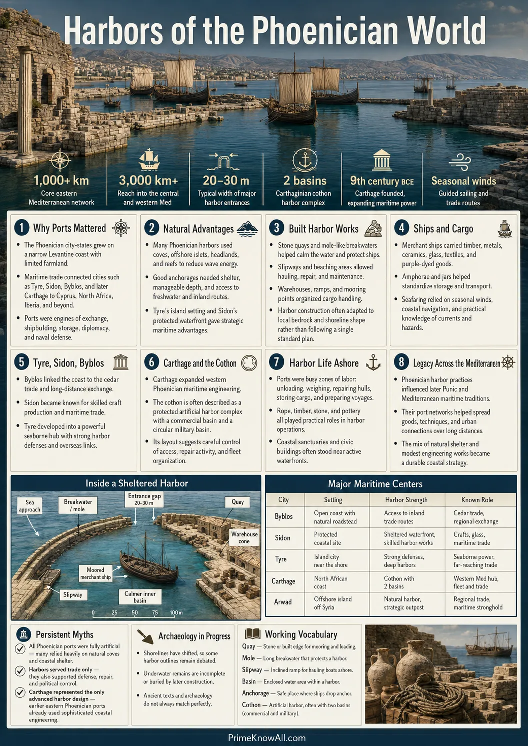
The best-known examples, including Tyre, Sidon, Byblos, Kition, Motya, and later Carthage, show how the Phoenicians turned small coastal advantages into a wide maritime network across the Mediterranean. Their ports helped move cedar timber, metals, glass, ceramics, wine, oil, textiles, purple dye, and people.
If you remember one thing: a Phoenician port was less like a single dock and more like a coastal machine—part harbor, part market, part workshop, part political checkpoint.
What To Keep In Mind
- Natural shelter came first: reefs, islands, bays, lagoons, and pocket beaches made many sites useful before heavy construction.
- Engineering came next: quays, moles, ramps, dredging, and ship sheds made ports more reliable for trade and naval work.
- Archaeology changes the picture: sediment cores and underwater finds now show that some “lost” Phoenician harbors sit below modern streets or silted coastal zones.
What Phoenician Ports Were Built To Do
Phoenician ports were built to solve four practical problems: shelter ships, move goods, repair vessels, and control access to the sea. In the eastern Mediterranean, where rocky coasts, seasonal winds, and narrow coastal plains shaped travel, a useful harbor could decide whether a city became a regional trading center or stayed a local settlement.
A port is a coastal place where ships can load, unload, wait, or receive support. A harbor is the sheltered water area inside or near that port. A quay, meaning a built landing edge for ships, allowed workers to handle cargo without dragging everything across a beach.
- Shelter: protected basins reduced wave damage and gave crews safer mooring points.
- Cargo handling: quays and open yards helped move amphorae, timber, metal ingots, and textiles.
- Repair: ramps and ship sheds allowed vessels to dry, be patched, and return to service.
- Control: narrow entrances, watch points, and city walls made ports easier to defend and tax.
- Storage: warehouses kept goods near the shoreline but inside the city’s economic orbit.
Think of the port like a modern airport terminal. The ship was only one part of the system. Behind it stood storage, repairs, schedules, security, payment, and people who knew how to move goods without delay.
How Natural Harbors Became Maritime Structures
The Phoenicians often improved what the coastline already offered. They did not always begin by cutting a perfect artificial basin into rock. Many early ports grew from coves, sand-protected bays, reef-backed anchorages, or island channels that already calmed the water.
This matters because port archaeology is not only about stone walls. Researchers also read mud, shells, sand layers, pollen, pottery, anchor stones, and marine organisms. A shift from coarse beach sand to finer protected silt can show that people changed how water moved inside a harbor.
- Reefs acted like natural breakwaters by absorbing wave energy.
- Small islands helped create inner and outer anchorages.
- Pocket beaches gave early ships a place to land before built quays appeared.
- Dredging kept basins usable when silt built up.
- Moles, meaning stone arms reaching into the water, helped block waves and shape entrances.
What This Means So Far
- A Phoenician harbor could start as a natural cove before becoming a built port.
- Sediment can preserve port history even when stone structures are buried or reused.
- The line between natural shelter and engineered structure was often gradual.
| Structure | Plain Meaning | Main Use | Where It Matters Most |
|---|---|---|---|
| Quay | A built landing edge beside water | Loading, unloading, and tying up ships | Trading ports such as Tyre, Sidon, and Carthage |
| Mole | A stone arm projecting into the sea | Breaking waves and shaping harbor entrances | Island and promontory cities exposed to wind |
| Ship Shed | A roofed bay with a sloped ramp | Hauling ships out of water for drying and repair | Kition and Carthage-style naval facilities |
| Cothon | An artificial protected basin, often linked with Punic ports | Military or controlled harbor use, depending on site | Carthage; debated or reinterpreted at other sites |
| Outer Anchorage | A deeper mooring area outside the inner harbor | Holding larger ships or overflow traffic | Sidon’s use of Zire island and similar coastal settings |
| Warehouse Zone | Storage space near the waterfront | Keeping amphorae, timber, ropes, metals, and trade goods close to ships | Large commercial ports and colonial trading posts |
Tyre: Island Port, Reef Shelter, And Purple-Dye Wealth
Tyre was one of the strongest Phoenician maritime cities because its island setting gave it shelter, defense, and direct sea access. It stood on the southern Lebanese coast and became linked with long-distance trade, purple dye production, and overseas colonies such as Carthage and Gadir, later Cádiz.
Tyre’s northern harbor is especially useful for understanding buried port landscapes. Geoarchaeological research indicates that the ancient northern harbor was once about twice the size of the modern fishing harbor. Much of that earlier basin is now hidden below the modern city center because sediment, shoreline change, and later building altered the coast.
- Reef protection: sandstone reefs helped create a lower-energy water area.
- Island security: the main city was harder to attack before Alexander’s causeway changed the shoreline.
- Warehouse logic: goods could move quickly between ships, market spaces, and storage zones.
- Colonial reach: Tyrian activity helped connect the Levant with North Africa, Sicily, Sardinia, Iberia, and the central Mediterranean.
Tyrian purple dye also explains why a port could shape more than trade volume. The dye came from sea snails and required labor, skill, and coastal processing space. A harbor city could connect the raw marine resource, workshop production, elite demand, and export routes in one place.
Sidon And Byblos: Older Coastal Cities With Layered Port Evidence
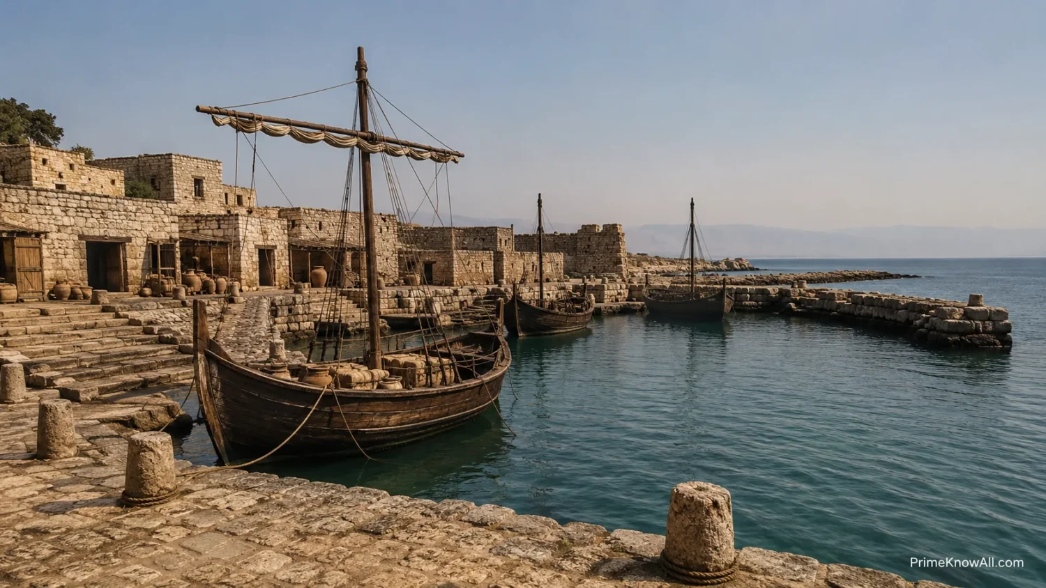
Sidon and Byblos show that Phoenician port history did not begin with large stone basins. Both cities grew from older coastal settlement patterns, and both used geography before heavy infrastructure became visible in the archaeological record.
Sidon Used Pocket Beaches And Outer Shelter
At Sidon, research points to northern and southern pocket beaches serving as early harbor zones in the Bronze Age. Later, as trade grew toward the end of the Late Bronze Age and into the Early Iron Age, people began modifying those natural anchorages. The lee of Zire island also worked as a deeper outer harbor.
- Early stage: natural beaches offered beaching and anchorage space.
- Modified stage: finer sediment hints at human changes to the northern harbor.
- Later problem: Roman and Byzantine dredging disturbed earlier Iron Age layers, making some details hard to recover.
Byblos Connected Port Life With Writing And Long Settlement
Byblos is often discussed for its long occupation and its link to the spread of the Phoenician alphabet. It also matters as a coastal trading city where maritime exchange helped connect Lebanon, Egypt, Cyprus, and the wider Mediterranean over many centuries.
- Location: Byblos sits on the Mediterranean coast north of Beirut.
- Long life: the site has evidence of occupation from Neolithic times.
- Trade role: its name became tied to papyrus exchange and later to the Greek word behind “Bible.”
A Useful Way To Read The Evidence
- Tyre shows how an island port could grow into a maritime power.
- Sidon shows how natural beaches could become managed harbor spaces.
- Byblos shows how port life, writing, and long-distance exchange could overlap.
Carthage And The Cothon: A Port Built For Trade And Fleet Control
Carthage gives the clearest image of a planned Punic harbor complex. Founded by Phoenicians on the Gulf of Tunis, it later became the major Punic power in the western Mediterranean, with a port system linked to trade, fleet maintenance, and city defense.
The famous cothon at Carthage is usually described as having two connected parts: an outer rectangular merchant harbor and an inner circular military basin. Ancient sources describe ship sheds and quays for up to 220 warships. Modern scholars treat the exact number with care, but the basic idea of a specialized naval harbor is supported by archaeological work and the visible shape of the site.
- Outer basin: handled commercial traffic and everyday maritime exchange.
- Inner basin: protected naval vessels and kept military movement under tighter control.
- Central island: likely served command, observation, and ship-support functions.
- Ship sheds: roofed bays helped dry and maintain wooden warships.
- Controlled entrances: narrow channels made access easier to monitor.
Carthage is also why many people picture Phoenician ports as perfect circular harbors, especially after seeing reconstructions in documentaries, online maps, or strategy games. That picture is useful, but it can mislead. Carthage was a late and highly developed Punic example, not the template for every Phoenician port.
Kition: Ship Sheds That Show The Navy On Land
Kition, in modern Larnaca on Cyprus, gives rare physical evidence for Phoenician naval infrastructure. At the Bamboula site, archaeologists found long, narrow ship sheds known as neosoikoi, built with sloped ramps where vessels could be hauled out of the water.
The preserved building was almost 40 meters long and included bays separated by masonry pillars. Its layout suggests use by triremes, fast warships powered by three rows of rowers. These ships needed more than water access. They needed drying, storage, hull care, oars, ropes, sails, and trained crews.
- Ship sheds protected wood: ancient hulls suffered if left in water too long.
- Sloped ramps saved labor: crews could pull vessels up stern first.
- Roofed bays protected gear: oars, sails, and rigging needed dry storage.
- Military planning became visible: the harbor was not only a place to arrive; it was a place to keep a fleet ready.
What The Naval Sites Add
- Carthage shows a large port system with separate commercial and military areas.
- Kition shows the land-based side of naval power: ramps, roofs, storage, and repair.
- A port was useful only when people could keep ships working, not just floating.
Motya Shows Why One Word Can Mislead Readers
Motya is a warning against labeling every rectangular basin a harbor. The Phoenician island-city off western Sicily was long discussed through its so-called “Kothon,” but a 2022 archaeological reinterpretation argued that the basin was not a harbor at all. It was more likely a sacred freshwater pool inside a large religious complex.
This update matters because it connects port studies with religion, water management, and navigation knowledge. The pool may have reflected stars and helped track celestial movement, while nearby temples and architectural alignments shaped how the space was used.
- Old reading: the basin looked like a Phoenician-style artificial harbor.
- New reading: excavation around the basin showed temples, sacred water, and ritual planning.
- Main lesson: shape alone is not enough; context decides meaning.
For readers, Motya is one of the most helpful recent examples because it shows how archaeology can correct a clean but wrong story. A basin can look maritime and still belong to a different part of city life.
What Maritime Archaeology Can Prove
Maritime archaeology can prove more than the existence of a dock. It can show water depth, sediment buildup, shoreline movement, dredging, trade goods, repair habits, and the changing border between city and sea.
Researchers use geoarchaeology, meaning the study of earth materials in human history, to rebuild ancient harbor environments. In Tyre and Sidon, sediment cores helped reveal older basins now hidden by later coastal change. In underwater sites such as Bajo de la Campana near Cartagena, cargo finds show how Phoenician trade moved raw materials and finished goods across long routes.
- Sediment cores show whether water was open, protected, brackish, or silted.
- Pottery helps date activity and identify trade connections.
- Anchors reveal mooring habits and ship size ranges.
- Hull fragments can preserve shipbuilding methods.
- Cargo scatter shows what a vessel carried and sometimes how it wrecked.
The Bajo de la Campana site is a clear case. The submerged rock rises from about 24 meters deep toward the surface and has caused wrecks for centuries. Excavations from 2007 to 2011 uncovered thousands of objects, giving a rare view of Phoenician trade in the western Mediterranean.
What The Evidence Can And Cannot Do
- It can show harbor use, even when the old shoreline is gone.
- It can link ships to trade routes, materials, and port labor.
- It cannot always name a builder, owner, or exact date without supporting finds.
Trade Goods And Port Work
Phoenician ports worked because they handled mixed cargo well. A ship could carry amphorae, metal ingots, timber, ivory, glass items, stone objects, food, rope, resin, tools, and personal goods. A port needed people who could unload, count, store, repair, tax, and redistribute these materials.
The cargo from Phoenician and Punic contexts shows a network that was not limited to luxury goods. Metals mattered because bronze and iron economies needed copper, tin, lead, and other raw materials. Amphorae mattered because liquids and food could move in standardized containers. Timber mattered because ships and buildings were hungry for good wood.
- Cedar and timber: linked ports with inland forests and shipbuilding needs.
- Metals: connected Levantine cities with Cyprus, Sardinia, Iberia, and other mining zones.
- Purple dye: tied coastal workshops to elite textile markets.
- Glass and ceramics: moved as trade goods and as containers for other products.
- Food and wine: supported both local markets and ship crews.
Port work was physical and organized. Someone had to lift jars, inspect ropes, mark ownership, move ballast, patch hulls, replace oars, and keep storage dry. The smooth sea routes visible on a map were built from many small tasks on shore.
How Phoenician Ports Shaped City Life
A Phoenician port shaped the city around it. Streets, markets, workshops, temples, walls, and elite houses often formed a tight relationship with the waterfront. The port was not outside the city’s life; it was one of the city’s main reasons for existing.
In many settings, the harbor connected four zones: sea, gate, market, and sanctuary. Goods entered by ship, passed through controlled spaces, moved into exchange networks, and often stood near religious buildings where vows, offerings, and civic identity mattered.
- Markets needed easy access to landing areas.
- Temples could stand near trade zones because travel, oaths, and protection were linked.
- Walls protected port wealth from raiding and siege.
- Workshops needed water, waste space, storage, and shipping access.
- Administration depended on counting, recording, taxing, and negotiating cargo.
Read A Phoenician Port From Sea To City
1. Open Water
Ships approach along coastwise routes, watching wind, reefs, islands, and headlands.
2. Outer Anchorage
Larger or waiting vessels hold outside the busiest harbor zone, where depth and shelter allow safer stops.
3. Entrance Channel
A narrow or managed approach lets the city control movement, inspection, and defense.
4. Inner Basin
Protected water reduces wave action and allows loading, unloading, and short-term mooring.
5. Quay And Ramp
Workers move amphorae, timber, metals, ropes, sails, and repair materials between ship and shore.
6. Warehouse And Workshop
Goods are counted, stored, repacked, repaired, dyed, processed, or prepared for inland travel.
7. Market, Temple, And Gate
The port connects economic life with civic control, religious protection, and long-distance identity.
The Human Side Of The Harbor
- A port needed sailors, pilots, carpenters, traders, scribes, guards, potters, and laborers.
- The waterfront linked trade with religion, because sea travel carried risk.
- A successful harbor changed land values, street layouts, and political power inside the city.
Phoenician Port Design In Daily Situations
The easiest way to understand these ports is to place them in everyday scenes. Each scene below shows how a structure or port habit solved a real problem.
- A merchant ship reaches Tyre after rough weather. Reef-sheltered water gives the crew a calmer place to wait before cargo is moved.
- A trireme at Kition needs repair after patrol duty. The sloped ramp lets workers haul it into a ship shed so the hull can dry and be checked.
- A trader arrives at Carthage with amphorae and metal goods. The commercial basin keeps cargo handling separate from the inner naval zone.
- A vessel waits near Sidon while the inner harbor is busy. An outer anchorage near an island gives more room without forcing every ship into the same basin.
- A dock worker sees jars from several regions stacked together. The port is acting as a sorting center, not just a place where one ship meets one buyer.
- A scholar finds fine silts below a modern street. Those sediments may mark a protected ancient harbor that later filled in and disappeared from view.
- A visitor sees Motya’s basin and assumes it was a dock. Nearby temples and freshwater evidence change the reading, showing why context matters.
Common Misconceptions About Phoenician Ports
Several popular ideas about Phoenician ports are too neat. The real picture is more varied, and that makes it more useful.
| Misconception | Better Reading | Why It Happens |
|---|---|---|
| Every Phoenician port had a circular cothon. | Only some Punic sites had artificial basins of that type, and Carthage is the best-known example. | Modern reconstructions of Carthage are memorable and often get applied too widely. |
| A harbor is always easy to see today. | Many ancient basins are buried below silt, buildings, or later city layers. | Modern coastlines look fixed, but ancient shorelines moved over centuries. |
| Ports were only for trade. | They also supported naval repair, storage, defense, religion, and political control. | Cargo finds are easier to imagine than administrative or ritual activity. |
| A stone quay proves the whole harbor plan. | One structure may show one phase, while the larger port changed over time. | Single finds are often easier to explain than layered coastal history. |
| Motya’s basin must be a harbor because it looks like one. | Recent work reads it as a sacred freshwater pool within a temple complex. | Shape can mislead when surrounding evidence is not considered. |
Limits Of This Explanation
Some details about Phoenician ports remain open because the evidence is uneven. Coastal cities were rebuilt many times, and later Roman, Byzantine, medieval, and modern construction disturbed earlier layers.
- Tyre and Sidon: older harbor zones are partly under modern urban areas, which limits excavation.
- Ship numbers: ancient claims about fleet capacity, such as Carthage’s 220 warships, should be read alongside archaeology, not as exact engineering records.
- Terminology: the word cothon can be useful, but it should not be pasted onto every basin without local proof.
- Dating: ports often changed in stages, so a quay, basin, or sediment layer may belong to a later phase than the city’s first maritime activity.
- Organic materials: wood, rope, sails, and baskets decay easily unless buried in special wet or low-oxygen conditions.
This is why careful language matters. It is safer to say “the evidence suggests” when archaeology points in one direction but does not close every possible reading.
Quick Test: Can You Read The Port Like An Archaeologist?
Use these short checks to test the main ideas. Tap each line to see the answer.
A city has a reef, a small bay, and fine harbor silt below later streets. What does that suggest?
It may suggest an older protected harbor environment. The reef and bay could have reduced wave energy, while fine silt can point to calmer water inside a managed or sheltered basin.
A rectangular basin sits near temples and freshwater evidence. Should it automatically be called a harbor?
No. Motya shows why setting matters. If the surrounding evidence points to ritual use, water management, and temple planning, the basin may not have been a dock.
Why did ship sheds matter in places such as Kition?
They helped crews haul ships out of water, dry wooden hulls, store gear, and keep vessels ready for reuse. A fleet needed shore support as much as sea skill.
Why is Carthage useful but risky as a model for all Phoenician ports?
Carthage gives a clear example of a planned Punic harbor complex, but it was a later and highly developed case. Smaller or older Phoenician ports could look very different.
What can a cargo wreck near a port reveal?
It can reveal trade routes, materials, storage habits, ship equipment, and the kinds of goods moving through a maritime network. It may not identify the exact owner or full route without more evidence.
Phoenician maritime structures were practical answers to wind, waves, trade, storage, repair, and control. Their ports worked because natural shelter and human planning were joined in the same coastal space.
The most common mistake is to imagine one standard Phoenician harbor design and then force every site into it. The rule to remember is simple: read the water, the shore, the structures, and the surrounding city together.
Sources
The sources below are selected because they come from official heritage bodies, academic publishers, university research pages, or established reference works.
- UNESCO World Heritage Centre – Tyre — Useful for Tyre’s World Heritage status, Phoenician maritime role, colony links, and preservation context. UNESCO is reliable here because it publishes official World Heritage property descriptions and conservation notes.
- UNESCO World Heritage Centre – Archaeological Site of Carthage — Useful for Carthage’s Phoenician foundation, Punic ports, Mediterranean exchange role, and listed site data. UNESCO is reliable because it documents protected heritage properties through formal nomination and review processes.
- UNESCO World Heritage Centre – Byblos — Useful for Byblos’s long occupation, Phoenician identity, and alphabet history. UNESCO is reliable because the page is tied to the official World Heritage List.
- French Ministry of Culture – Kition: A Capital City of Cyprus — Useful for Kition-Bamboula ship sheds, trireme interpretation, and archaeological context. This is reliable because it is produced by a national culture ministry and presents specialist excavation material.
- University of Haifa – Geoarchaeology of Tyre’s Ancient Northern Harbour, Phoenicia — Useful for Tyre’s buried harbor basin, reef protection, sediment evidence, and harbor-size reconstruction. The page is reliable because it records a peer-reviewed Journal of Archaeological Science article.
- University of Haifa – Geoarchaeology of Sidon’s Ancient Harbours, Phoenicia — Useful for Sidon’s pocket beaches, Zire island anchorage, sediment phases, and later shoreline change. It is reliable because it points to a peer-reviewed archaeological study.
- Cambridge Core / Antiquity – The Sacred Pool of Ba‘al: A Reinterpretation of the ‘Kothon’ at Motya — Useful for the updated 2022 interpretation of Motya’s basin as a sacred freshwater pool rather than a harbor. It is reliable because Antiquity is a peer-reviewed archaeology journal.
- Museo Nacional de Arqueología Subacuática / Spanish Ministry of Culture – Bajo de la Campana — Useful for the underwater site near Cartagena, excavation history, submerged rock setting, and Phoenician wreck material. It is reliable because it comes from Spain’s official underwater archaeology museum.
- Encyclopaedia Britannica – The Cothon — Useful as a concise reference for the artificial harbor at Carthage and the distinction between merchant and military basins. Britannica is reliable as an edited reference source, though detailed interpretation should still be checked against archaeology.
Frequently Asked Questions
What were Phoenician ports used for?
Phoenician ports were used for trade, ship repair, storage, defense, navigation support, and civic control. They moved goods such as timber, metals, amphorae, textiles, glass, and purple dye across the Mediterranean.
Did all Phoenician ports have a cothon?
No. The cothon is mainly associated with Punic artificial harbor basins, especially Carthage. Many Phoenician ports used natural bays, reefs, pocket beaches, islands, quays, and outer anchorages instead.
Why was Tyre an important Phoenician port?
Tyre combined island defense, reef-sheltered harbor space, strong trade links, and purple-dye production. It also became associated with overseas colonies and long-distance maritime exchange.
What made Carthage’s harbor different?
Carthage had a planned port system with a commercial basin and a circular military harbor. Ancient accounts describe ship sheds and quays for a large fleet, while archaeology supports the idea of specialized naval infrastructure.
What did ship sheds do in Phoenician ports?
Ship sheds protected vessels and equipment on land. They allowed crews to haul ships up ramps, dry wooden hulls, store gear, and carry out maintenance between voyages or patrols.
Was Motya’s cothon really a harbor?
Recent research argues that Motya’s so-called cothon was more likely a sacred freshwater pool inside a temple complex. This shows why archaeologists must read a basin together with its surrounding structures.
Why are some Phoenician harbors hard to find today?
Many ancient harbors were filled by sediment, altered by shoreline movement, covered by later buildings, or changed by Roman and Byzantine engineering. Some now sit beneath modern streets or silted coastal zones.