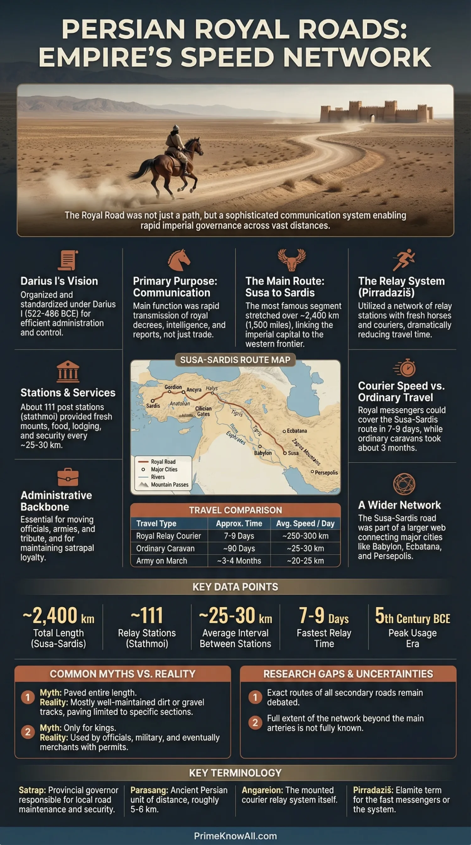
The Persian Royal Roads were a state-run road and relay network shaped under Darius I to move orders, officials, intelligence, and goods across the Achaemenid Empire. The best-known westward route ran for more than 2,400 km between Susa and Sardis, but the larger story is not one road alone; it is a timed communication network built from roads, stations, riders, scribes, and provincial authority.
What To Keep In Mind
- The road was a network, not just a line on a map. The Sardis–Susa route is the most famous part, but other royal roads linked Susa, Persepolis, Babylon, Ecbatana, and more.
- Its first job was communication. Trade benefited from it, but the road mattered most because the king could send orders and receive reports fast.
- Herodotus gives the classic numbers. He lists 107 stages, 450 parasangs, and about 90 days for ordinary travel on the Sardis–Susa journey.
- The courier relay changed everything. Fresh horses and riders turned distance into scheduled movement, which is why the road feels oddly modern.
The Persian Empire solved a hard political problem with infrastructure: how to make a very large state behave as if its edges were closer to the center.
That is why the Royal Roads matter. They were not just a travel route for merchants or armies. They let the Achaemenid court send a decision, receive a report, inspect a province, move rations, and project royal presence across several ecological zones and language communities without waiting for the seasons to do all the scheduling.
If You Remember One Thing… the Persian Royal Roads worked because they turned long distance into repeatable intervals. A road mattered, but the real advantage came from the stations, horses, scribes, seals, and officials attached to it.
What The Persian Royal Roads Were
The Persian Royal Roads were an imperial communication network, with one famous trunk route and several linked corridors used by the Achaemenid state. In simple terms, this was the empire’s official long-distance delivery system.
Darius I, who ruled from 522 to 486 BCE, is usually credited with organizing and improving the best-known route between Susa and Sardis. Some western stretches were older than Persian rule and may have reused earlier Assyrian or Anatolian lines of movement. That matters because the Royal Road was not created from empty land. It was a state upgrade of older corridors, then tied into a wider Achaemenid administrative web.
- A satrapy is a province governed by a satrap, the king’s regional official.
- A parasang is an ancient travel measure used by Greek authors for Persian distances.
- Pirradaziš is an Elamite term usually understood as an express messenger.
- Angareion is the Greek label for the Persian relay courier service.
The usual picture of one neat stone highway misses the point. A better image is a managed corridor network in which the court, local governors, staging posts, and scribes all played a part. A road without that support would still be useful. The Royal Roads became politically valuable because the state kept them usable, legible, and connected to authority.
Where The Best-Known Route Ran
The most famous Royal Road route ran west to east between Sardis in western Anatolia and Susa in the imperial heartland. Greek authors focus on this itinerary because it linked the Persian center to the empire’s Aegean-facing edge, where Greek observers could actually see the system.
Herodotus breaks the journey into regions rather than modern countries: Lydia and Phrygia, Cappadocia, Cilicia, Armenia, Matiene, and Cissia. He also notices defiles, fortresses, ferries, and river crossings, which is useful because it shows the road was not just a line on flat ground. It was a route planned through terrain and guarded choke points.
| Route Section | Stages | Parasangs | What It Suggests |
|---|---|---|---|
| Lydia And Phrygia | 20 | 94.5 | Dense western corridor with established movement and lodging. |
| Cappadocia | 28 | 104 | Long inland passage controlled through fortified access points. |
| Cilicia | 3 | 15.5 | Short but strategic section tied to mountain gates and frontier control. |
| Armenia | 15 | 56.5 | A route shaped by rivers, crossings, and guarded transit. |
| Matiene | 34 | 137 | The longest listed stretch, showing how varied the inland route could be. |
| Cissia To Susa | 11 | 42.5 | Final approach into the royal zone around Susa. |
| Total | 107 | 450 | Herodotus’ full count for the Sardis–Susa road. |
Those numbers produce a route of roughly three months for standard travel. That long duration is not a weakness in the text. It helps explain why the relay courier service impressed Greek observers so much. Ordinary movement and urgent movement were not the same thing.
Pause Here
- The Sardis–Susa road is the best documented route, not the whole network.
- Herodotus’ list of regions, gates, rivers, and forts shows a road shaped by control points, not just mileage.
- Travel time only makes sense when you separate ordinary journeys from relay courier speed.
How Messages Moved So Fast
The Royal Roads were fast because the message did not depend on one exhausted rider. The Persians broke movement into stages, then linked those stages with fresh horses, ready personnel, and official stops.
Herodotus’ famous line about couriers being stopped by neither snow, rain, heat, nor night survives because it captures the idea exactly: the empire made speed procedural. Later scholarship and archive work also point to service facilities spaced at regular intervals, often around 25–30 km, which would keep animals, supplies, and riders in working order. A modern estimate often cited for top-tier Achaemenid message traffic is around 230 km per day under relay conditions. That figure should be treated as an estimate, not a stopwatch reading, but it helps explain why a route of more than 2,400 km could be crossed in roughly nine days by royal messengers.
- Step 1: a message is drafted, authorized, and sealed near the court or another official center.
- Step 2: the first courier rides one segment, not the whole empire.
- Step 3: at a station, the message is passed to the next rider or horse team.
- Step 4: rivers, ferries, and mountain gates are handled through known crossing points rather than improvisation.
- Step 5: the message reaches a satrapal capital or another administrative hub, where it can be copied, archived, or acted on.
How A Royal Message Likely Moved
A decision begins at Susa, Persepolis, or another official node.
Royal OrderSealArchive Copy
For cross-regional use, Aramaic often helped communication travel across many languages.
A courier rides one managed stretch rather than the whole route.
Timed StageFresh Horse
Food, remounts, and personnel keep the chain moving. Some service points were set at roughly 25–30 km intervals.
Fortresses, defiles, ferries, and river crossings reduce uncertainty at the hardest points.
A satrap or local office receives the order, records it, and puts it into action.
Reports, tax data, and intelligence travel back through the same relay logic.
>2,400 km Main Route107 Stages In Herodotus~9 Days For Urgent Courier Traffic
One analogy helps here. A relay station on the Royal Road worked a bit like a router on the internet: the message kept moving, while the local carrier changed at each stop. That is why the road feels modern. The smart part was not the horse alone. It was the handoff logic.
Who Used The Roads And Why
The road served more than one audience, but royal administration came first. Messengers, emissaries, inspectors, governors, military units, tribute convoys, and court personnel all benefited from the same managed corridors.
This is where the road becomes more than transport. It becomes imperial coordination. Messages could move from the court to satrapal centers such as Sardis, Babylon, Memphis, or Ecbatana. Aramaic helped written communication move across a multilingual empire. Even royal inscriptions mattered here: the Bisotun text, for example, was not just carved on rock; evidence suggests it was also distributed in other written forms.
- Royal couriers carried urgent orders, reports, and intelligence.
- Satraps and their staffs used the roads to govern provinces and answer the center.
- Inspectors and envoys traveled to check conditions, negotiate, and report.
- Merchants and local travelers gained from the same road environment, even if commerce was not the first reason the state maintained it.
- Armies used major corridors because broad, known routes reduce logistical surprises.
That last point matters. Roads do not only move people. They move predictability. Once a court knows how long a stage takes, where water is available, where bridges or ferries are found, and where remounts wait, decision-making becomes less blind. That is one reason the Royal Roads should be seen as a communication asset first and a travel convenience second.
What This Means
- The road linked authority to mobility.
- Language choice, especially Aramaic for many written exchanges, was part of the network, not a side detail.
- Trade used the road, but the road’s first advantage was that the empire could respond faster.
What The Archaeology Shows
Archaeology does not give one clean ribbon across the whole empire, but it does confirm that at least some royal-road segments were wide, engineered, and built for repeated use. That matters because it moves the topic beyond literary admiration.
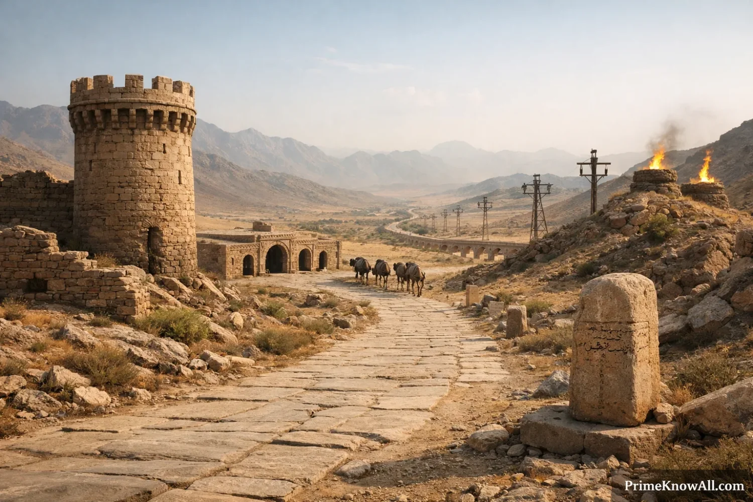
Near Gordion, excavators described a road of hard-packed gravel with stone curbs and a width of about 6.25 meters. That is not a dusty footpath. It suggests deliberate construction, two-way traffic, and a corridor fit for wheeled movement as well as mounted travel. Still, this should not be turned into a fantasy of one identical surface from end to end. Road quality likely varied by terrain, local maintenance, and function.
Recent research has sharpened the picture further. A 2025 Cambridge-linked study used GIS and environmental modeling on the Susa–Persepolis corridor and argued that “royal” roads were not merely common roads used by kings. They were roads shaped by royal logistical needs, including width, slope tolerance, access to support points, and room for court mobility. That is a useful update because it shifts the question from “Where was the road?” to “What made a road royal?”
- Archaeology confirms real built segments.
- Landscape modeling helps fill gaps where the road itself is fragmentary.
- Archives explain usage patterns that stones alone cannot show.
What People Usually Get Wrong
The common mistakes are easy to understand because the Royal Road is usually taught in a very compressed way. That short version is memorable, but it leaves out how the network actually worked.
- Wrong: It was one perfectly straight road. Correction: It was a network with one especially famous western trunk route. Why this happens: Herodotus describes a single itinerary, and later readers often treat it as the entire system.
- Wrong: It was mainly a merchant road. Correction: The road clearly helped trade, but its first value lay in state communication and control. Why this happens: busy roads naturally attract merchants, so commerce tends to dominate retellings.
- Wrong: It was paved like a Roman road from one end to the other. Correction: Surfaces likely varied; one excavated stretch near Gordion is hard-packed gravel with curbing, not a universal Roman-style stone pavement. Why this happens: “royal road” sounds more standardized than ancient road reality.
- Wrong: Herodotus tells the whole story by himself. Correction: Herodotus is essential, but archive texts, archaeology, and newer spatial modeling correct and extend his picture. Why this happens: his description is vivid and often quoted on its own.
- Wrong: Speed came from heroic riders alone. Correction: speed came from relay design—stations, horses, schedules, and official backing. Why this happens: people remember the rider and forget the infrastructure behind the rider.
Hold On To This
- The road was not special only because it was long.
- It was special because the empire made it usable on schedule.
- The best correction is simple: think network plus relay, not single road plus legend.
How This Would Feel In Daily Life
The easiest way to understand the Royal Roads is to place them inside ordinary imperial problems. Each short scene below shows what the network solved in practice.
- A satrap in Sardis needs a sealed order before changing tax handling. The road matters because provincial rule works better when policy moves faster than rumor.
- A frontier report reaches the court after trouble near a river crossing. The relay matters because bad news loses value when it arrives too late.
- A court official travels with attendants between Susa and Persepolis. The road matters because royal mobility needs more than a path; it needs supply, width, and predictable staging points.
- A merchant joins a corridor already kept usable for state traffic. The road matters because public order and regular stations lower the cost of private movement too.
- A message crosses a mountain gate in Cilicia. The road matters because narrow terrain turns control points into communication chokepoints.
- A scribe prepares a text in Aramaic for use beyond one language zone. The road matters because speed is wasted if the receiver cannot read the order.
- A return report comes back from a province after the order is carried out. The road matters because rule is not only giving commands; it is getting feedback.
If any of that sounds familiar, it should. Modern life also depends on handoffs: package hubs, airline slots, fiber nodes, server relays, customs checkpoints. The Persian Royal Roads were not modern technology, but they solved a recognizably modern coordination problem.
What We Still Cannot Pin Down
There are firm facts here, but there are also limits. Some parts of the Royal Road can be mapped with confidence; others are still debated.
What Is Fairly Solid
- Darius I is closely tied to the system’s organization and improvement.
- The Sardis–Susa route was a major official road.
- Herodotus’ figures on stages, parasangs, and courier speed shaped the classic picture.
- Archive evidence confirms express messengers and the wider administrative value of the road network.
What Is Less Certain
- The exact line of every segment across all regions.
- How uniform road surfaces and station design were from one area to another.
- How often ordinary travelers had the same access as official traffic.
- How many written orders have vanished because they were made on perishable materials.
That uncertainty is not a flaw in the subject. It is part of honest history. Roads survive unevenly. Archives are partial. A Greek observer saw the road from one political angle, while modern archaeology and the Persepolis Fortification Archive recover other pieces of the same story. The best reading keeps all three in view: text, landscape, and administration.
Why The Road Still Feels Modern
The Royal Roads still feel modern because they show that distance is not just geography; it is also an organizational problem. The Achaemenids reduced distance by breaking it into managed parts and attaching those parts to authority.
That is also why newer research matters. The older textbook version admired the road for being long. Newer work asks how the corridor handled court movement, administrative messaging, terrain, logistics, and support nodes. That shift makes the subject clearer, not harder. It also fits the wider lesson of imperial history: states do not rule space by owning land alone. They rule space by keeping information in motion.
The Persian Royal Roads turned a huge empire into something more governable by linking roads, stations, scribes, horses, and provincial officials into one timed chain. Their lasting interest comes from that mix of infrastructure and communication, not from mileage alone.
The most common mistake is to picture one polished highway and stop there.
Remember this rule: the real achievement was not the road by itself, but the road as a managed relay network.
Sources
- University of Chicago – Herodotus, Histories Book V — Used for the classic route breakdown: 107 stages, 450 parasangs, and the 90-day standard journey. Why reliable? It is a hosted text of a primary ancient source, which is the base evidence for the best-known itinerary.
- University of Chicago – Herodotus, Histories Book VIII — Used for the famous courier description about snow, rain, heat, and darkness. Why reliable? This is the direct primary source behind the later postal saying and the relay-courier image.
- Encyclopaedia Britannica – Persian Royal Road — Used for the broad length of more than 2,400 km, Darius I’s role, the nine-day courier figure, and Alexander’s later use of the road. Why reliable? Britannica is a long-standing editorial reference with signed and fact-checked entries.
- Encyclopaedia Iranica – Achaemenid Royal Communication — Used for relay messaging, satrapal communication, and the role of Aramaic in written exchange. Why reliable? Iranica is a specialist scholarly encyclopedia focused on Iranian history and culture.
- Encyclopaedia Iranica – Commerce II: In The Achaemenid Period — Used for the road’s trade setting and the summary of service facilities placed roughly every 25–30 km. Why reliable? It is a focused reference article written for scholarly use, with citations to classical and modern research.
- Institute for the Study of Ancient Cultures – Persepolis Fortification Archive — Used to explain why archive tablets matter for travel, administration, and messenger evidence beyond Greek authors. Why reliable? This is the official project page of the institution that has led much of the archive’s study.
- Antiquity / Cambridge University Press – “Royal” Road, “Royal” Needs — Used for the 2025 argument that royal roads should be defined by logistical and environmental needs, not by fame alone. Why reliable? It is a peer-reviewed journal publication from a major academic press.
- University of Cambridge – PersianTRAIL Project — Used for the current GIS and remote-sensing effort to reconstruct Persian royal-road corridors. Why reliable? It is the official page of an active university research project.
- DergiPark – Rodney S. Young, Gordion Excavations, 1956 — Used for the excavated road section near Gordion described as hard-packed gravel with stone curbs and a width of about 6.25 m. Why reliable? It preserves a published excavation report tied to direct field evidence.
FAQ
Who built the Persian Royal Road?
The best-known form of the Royal Road is usually linked to Darius I, who organized and improved older routes into a more effective imperial corridor. Some western stretches were likely older than Persian rule, so it is better to think of Darius as the ruler who standardized and integrated the system rather than inventing every mile from scratch.
How long was the Persian Royal Road?
The famous Sardis–Susa route is usually given as more than 2,400 km or about 1,500 miles. That figure describes the best-known trunk route, not the full span of every royal road in the empire.
How fast could messages travel on it?
Greek and later reference works describe royal couriers covering the Sardis–Susa route in about nine days, while ordinary travel could take about three months. The difference came from the relay method: fresh horses, staged stops, and official support.
Was it one road or many roads?
It was many roads, with one especially famous road between Sardis and Susa. Newer scholarship prefers to speak of an Achaemenid road network, because royal mobility and communication depended on several linked corridors, not one isolated highway.
What languages moved through the network?
The empire was multilingual, but Aramaic played a large role in written communication across regions. That made long-distance administration easier because scribes did not need every province to share the same spoken language.
Did the Royal Road help trade too?
Yes. Even if the state built and maintained the road mainly for administration, messaging, and movement of officials, merchants and local travelers also benefited from safer, better-known corridors and service points.