Ancient roads in Mesopotamia were not one neat line across a map; they were a working network of river routes, canal banks, caravan tracks, city approaches, and state roads. They helped move grain, wool, copper, tin, timber, letters, officials, soldiers, tax records, and ideas between the Tigris, the Euphrates, Anatolia, Syria, the Levant, Iran, and the Persian Gulf.
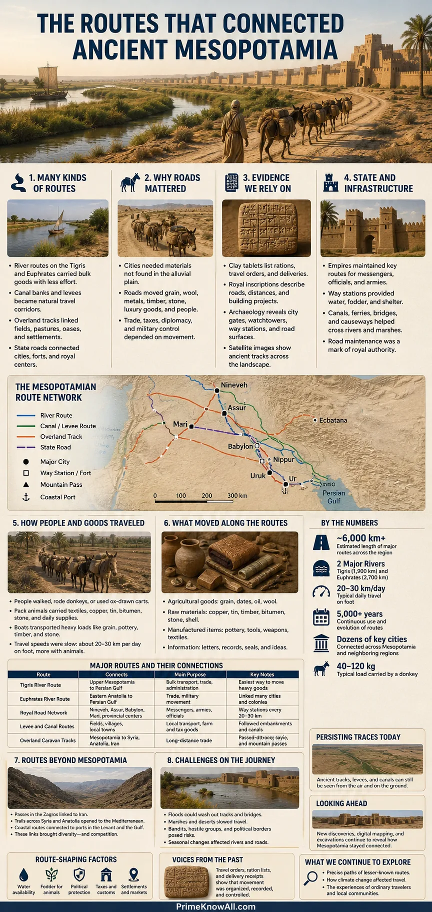
In the shortest useful answer: Mesopotamian roads grew from daily movement. People walked between fields and settlements, donkeys carried trade goods, boats used rivers and canals, and empires later organized preferred routes for messengers and officials. The road system was less like a modern highway map and more like a living circulation system shaped by water, mud, animals, archives, and power.
If you remember one thing, remember this: Mesopotamia’s roads worked because they joined land movement with water movement. A caravan track, a river bend, a wharf, a canal, a city gate, and a clay tablet could all belong to the same transport story.
What Ancient Roads in Mesopotamia Were
Ancient Mesopotamian roads were practical movement corridors used by people, animals, carts, armies, messengers, and merchants. Some were worn tracks across dry ground. Some followed levees, canals, and riverbanks. Others became official routes maintained for state communication, especially in the Neo-Assyrian Empire.
The word road can be misleading if it suggests stone paving, lane markings, and fixed borders. In Mesopotamia, a road could be a path made by repeated travel. A hollow way, for example, is a shallow sunken track formed when people and animals crossed the same ground for long periods. These routes can still appear in satellite images as dark lines because they collect moisture and support thicker vegetation.
- Local paths connected fields, canals, herding areas, and nearby settlements.
- Caravan tracks linked cities such as Ashur, Mari, Babylon, Ur, Nippur, and later Nineveh to wider trade zones.
- River roads followed the Tigris and Euphrates, where boats carried heavy cargo more easily than donkeys could.
- State routes served officials, messengers, garrisons, and provincial governors.
Useful pause:
- Mesopotamian roads were often tracks and route zones, not paved streets.
- The best routes usually stayed close to water, fodder, settlements, and political protection.
- Many roads are known through a mix of texts, archaeology, satellite imagery, and landscape marks.
Why Roads Mattered Between the Tigris and Euphrates
Roads mattered because Mesopotamia had cities before it had enough local raw materials. Southern Mesopotamia could grow grain and dates, but it lacked many materials needed for elite objects, tools, buildings, and trade. Metal, stone, timber, and some luxury goods had to come from outside the alluvial plain.
That geography made movement essential. Ur, Uruk, Nippur, Babylon, Ashur, Mari, and Nineveh were not isolated dots. They were nodes in a changing system of water routes, desert edges, pasture zones, mountain passes, and merchant districts. A road could turn a city into a customs point, a royal station, a military staging area, or a trade hub.
Mesopotamia, meaning “between rivers,” was a region shaped by the Tigris and Euphrates. But the rivers did not solve every transport problem. Some goods moved by boat. Others had to leave the river and cross land toward Anatolia, Syria, the Zagros Mountains, the Levant, or the Gulf.
- Grain and dates moved from irrigated farms toward cities and temples.
- Tin and textiles moved with Assyrian merchants into Anatolia.
- Copper, silver, and gold came back through trade networks.
- Letters and orders moved between rulers, governors, merchants, and families.
- Troops and officials used preferred roads when states expanded.
A Simple Definition of a Route Network
A route network is a connected set of paths, stops, and transfer points that allows people and goods to move from one place to another. In Mesopotamia, that network included roads, river passages, canals, ports, gates, post stations, market quarters, and caravan stops.
The Main Types of Mesopotamian Roads
Mesopotamia used several kinds of roads because no single route type fit every landscape. A donkey caravan, a reed boat, a wheeled wagon, and a royal messenger each needed different conditions. Distance, water access, security, season, and cargo weight all shaped the route.
| Route Type | How It Worked | Best For | Common Limits |
|---|---|---|---|
| River Route | Boats moved along the Tigris, Euphrates, and connected waterways. | Heavy goods, bulk grain, timber, oil, wine, metals | Floods, low water, shifting channels, political control points |
| Canal Bank Route | People and animals moved beside irrigation or transport canals. | Local farming, city supply, short-distance movement | Silt, maintenance needs, seasonal water changes |
| Caravan Track | Donkeys carried loads between cities, valleys, and trade colonies. | Tin, textiles, letters, small valuable cargo | Slow pace, animal fatigue, tolls, weather, security risks |
| Hollow Way | Repeated foot and animal traffic wore shallow depressions into the ground. | Village-to-field movement, settlement links, herding paths | Hard to date exactly, often visible only from above |
| Royal or State Road | Officials and envoys used privileged routes with stations or local support. | Letters, orders, military movement, administration | Access could be restricted to state business |
The table also shows why the phrase “ancient road” needs care. A road could be visible on the ground, recorded in a letter, implied by a caravan account, or reconstructed through satellite imagery. The evidence is layered, not tidy.
What this means in plain terms:
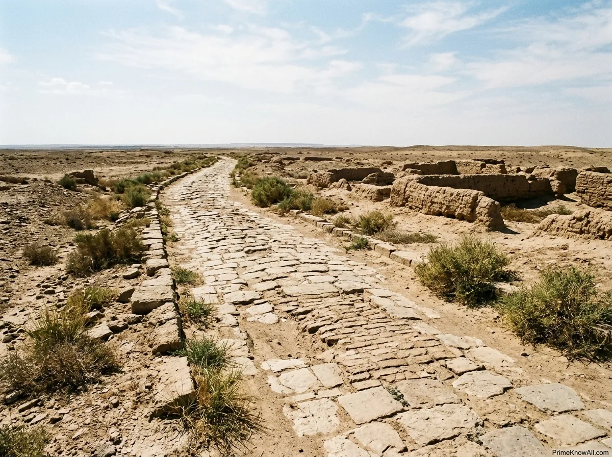
- Mesopotamian roads were part of a mixed transport system.
- Water routes were often better for heavy cargo, while land roads handled caravans, messages, and local travel.
- The same journey could use boat, donkey, footpath, and city gate in one chain.
How Geography Shaped Every Road
The geography of Mesopotamia made roads depend on water, soil, and season. In the south, the alluvial plain was flat and fertile but muddy, canal-cut, and exposed to river shifts. In the north, routes crossed drier steppe, rolling plains, and approaches toward the Zagros and Taurus mountain zones.
The Tigris and Euphrates did not stay fixed in one simple shape over thousands of years. Channels shifted. Canals filled with silt. Fields moved. Some old settlement mounds now sit far from present-day rivers because the watercourses changed. This matters because an ancient road may look strange on a modern map unless the older river and canal system is considered.
- Southern Mesopotamia relied heavily on irrigation canals, levees, and river-linked transport.
- Northern Mesopotamia shows many hollow ways, especially around early urban sites and settlement clusters.
- The Euphrates corridor helped connect Syria, Mari, central Mesopotamia, and routes westward.
- The Tigris corridor linked Assyrian heartlands, cities, and later imperial centers.
- Mountain-edge routes mattered for metals, timber, stone, and contact with Anatolia and Iran.
Why Roads Often Followed Water
Roads often followed water because water solved several problems at once. It supported people, pack animals, crops, boats, reeds, pasture, and settlements. A dry shortcut across open steppe could save distance, but a route near water was safer for repeated travel.
A useful analogy: Mesopotamian roads worked like the paths inside a busy market. Some paths were wide and official, some were narrow and local, and some changed as stalls, crowds, and gates moved. The pattern still served a purpose: it guided movement toward places where exchange could happen.
Hollow Ways: Roads That Archaeologists Can See From Space
Hollow ways are among the clearest physical traces of ancient movement in northern Mesopotamia. They are shallow, linear depressions made by repeated human and animal traffic. Over time, movement disturbed the soil surface, changed drainage, and created lines that can show up in aerial and satellite images.
In parts of northern Mesopotamia, researchers have mapped more than 6,000 kilometers of old trackways using declassified CORONA satellite photographs from the 1960s and 1970s. That matters because many landscapes have since been altered by modern farming, roads, dams, and urban growth.
- Radial hollow ways spread out from large settlement mounds, suggesting daily movement between city, fields, and pastures.
- Longer cross-country routes linked settlements over wider distances.
- Vegetation marks can reveal old paths because sunken lines collect extra moisture.
- Remote sensing helps detect routes that are hard to see while standing on the ground.
Remote sensing is the study of places from a distance, usually with satellite images, aerial photographs, or drone data. For ancient roads, it helps researchers see large patterns that a single excavation trench would miss.
Small field note:
- A hollow way is not usually a dug road; it is a worn route.
- It may show daily life better than royal inscriptions do.
- It reminds us that ordinary movement can leave huge landscape marks.
The River Road: Why Boats and Roads Belonged Together
The Tigris and Euphrates were not just rivers; they were transport lines. For heavy cargo, water could be more efficient than overland travel. Timber, grain, oil, wine, and metal could move by boat where channels allowed it, then transfer to land routes near ports, crossings, or cities.
Mari is one of the best examples. It stood near the middle Euphrates, where river movement and caravan movement met. Its port, known by the Akkadian word karum, served merchants and helped organize movement by river, canal, and land. A karum is a wharf or trading quarter where merchants handled goods, records, and exchange.
The river route did not erase land roads. It made them more useful. Goods might float downstream, stop at a wharf, move by donkey caravan across a dry zone, then join another river or city route. Roads and rivers worked together like transfer points in a modern delivery network.
- Mari connected Euphrates traffic with caravan routes toward the Mediterranean, Palmyra, and the Tigris Valley.
- Canals supplied water and sometimes supported transport near cities.
- Ports and wharves turned river movement into trade administration.
- Riverbanks also served as paths for animals, workers, and local traffic.
Caravan Roads and the Old Assyrian Trade
The Old Assyrian trade network shows how organized overland roads could become. Around the early second millennium BCE, merchants from Ashur traveled to Anatolia, especially to Kanesh at Kültepe. They used donkey caravans to move tin and textiles north and brought back silver, gold, and copper.
This was not casual wandering. The merchants wrote letters, kept accounts, recorded loans, used sealed clay envelopes, and tracked expenses. One Metropolitan Museum caravan account describes a six-to-eight-week journey from Ashur to Kanesh by donkey caravan. That one detail turns an abstract “trade route” into something real: weeks of pacing, packing, feeding animals, paying fees, and protecting goods.
UNESCO notes that the private archives of Kültepe-Kanesh have yielded about 23,500 clay tablets and envelopes. These records are especially valuable because they come from merchant households, not only palaces and temples. They show roads from the viewpoint of people who paid for bags, donkeys, taxes, debt, partnerships, and risk.
- Tin mattered because bronze needs copper and tin.
- Textiles were high-value trade goods that could travel by caravan.
- Donkeys were the main pack animals in this Middle Bronze Age system.
- Clay tablets acted like portable business records.
- Kanesh served as a major Anatolian trade center linked to Mesopotamia.
What the merchant tablets teach:
- Roads were also paperwork systems, even when the “paper” was clay.
- Long-distance trade depended on trust, credit, family ties, and repeated routes.
- A caravan road was an economic machine made of animals, contracts, stops, and people.
The Assyrian King’s Road and State Communication
The Neo-Assyrian Empire turned some roads into privileged state routes. The Assyrian “King’s Road,” known in Akkadian as hūl šarri, was used for official communication, royal envoys, troop movement, and contact between the king and provincial officials.
This system included road stations called bēt mardēti, meaning a house or station for a route stage. Governors were expected to maintain stations in useful places. These stations supported official travelers and transport animals, but they were not open commercial caravanserais in the later medieval sense. Their purpose was state movement, not general hospitality.
That difference matters. A merchant road and a royal road could overlap on the landscape, but they did not always serve the same users. A trader wanted profit and protection. A king wanted information, obedience, supply, and speed.
- Royal envoys carried letters and orders.
- Provincial governors helped maintain official routes and stations.
- Post stations gave shelter and support to state travelers.
- Military movement could follow major roads during campaigns.
- Administrative control became easier when messages moved reliably.
Why State Roads Changed Government
A large empire needs fast information. Without reliable routes, orders slow down, governors act on old news, and armies arrive late. The Assyrian communication network helped rulers keep distant provinces tied to the center. It did not remove all delay, but it reduced the isolation of far places.
A Text-Based Route Map Through Mesopotamia
The easiest way to picture Mesopotamian roads is to follow the movement of goods and messages. The same region could contain a river artery, a caravan crossing, a field path, and a royal route. The blocks below show how those parts fit together.
Southern Alluvial Plain
Ur, Uruk, Eridu, Nippur, and Babylon sat in a landscape shaped by canals, fields, levees, mudbrick cities, and shifting river channels. Roads here often worked beside irrigation and river transport.
Middle Euphrates Corridor
Mari used its position near the Euphrates to connect boats, canals, wharves, and caravan routes. This area acted as a transfer zone between southern Mesopotamia, Syria, Anatolia, and routes westward.
Northern Mesopotamian Steppe
Settlement mounds, fields, pastures, and caravan paths left hollow ways visible in remote sensing. These routes show daily movement, not just royal travel.
Ashur to Kanesh
Old Assyrian merchants moved tin and textiles by donkey caravan toward Anatolia. Clay tablets from Kültepe-Kanesh record costs, loans, disputes, and the human side of long-distance road trade.
Assyrian Imperial Routes
Later Assyrian rulers used privileged roads and stations for state communication. These routes helped move letters, officials, troops, and orders across a large empire.
Roads, Cities, and Power
Roads made cities stronger when cities could control movement. A city at a river bend, crossing point, canal junction, or caravan gate could tax goods, protect merchants, store grain, host scribes, and send orders. This is why places such as Mari and Kanesh became more than settlements. They became movement managers.
Control did not always mean direct ownership of every path. Often it meant controlling chokepoints: gates, ports, bridges, fords, canals, storage houses, or safe stops. A ruler did not need to patrol every kilometer if travelers had to pass through a few useful places.
- City gates controlled who entered with animals and goods.
- Wharves turned boat traffic into taxable trade.
- Canal systems supported food supply and local movement.
- Merchant quarters held archives, contracts, and storage.
- Road stations supported officials and messengers.
What becomes clear here:
- A road was also a tax route, a news route, and a supply route.
- Power often sat where land routes met water routes.
- Archives show movement as an administrative habit, not only a physical act.
What People and Goods Moved Along These Roads
Mesopotamian roads moved more than trade goods. They moved habits, legal forms, stories, scripts, seals, measurements, animals, and technologies. When merchants carried tin and textiles, they also carried the writing practices and accounting habits that made long-distance business possible.
Some goods were bulky and local. Others were small, rare, and worth the risk of long-distance travel. Tin is a good example: it was valuable because it helped make bronze when mixed with copper. Lapis lazuli, silver, timber, and fine textiles also moved through wider exchange zones, though not always on one continuous “road” from start to finish.
- Food: grain, dates, oil, beer ingredients, livestock products.
- Craft materials: copper, tin, silver, gold, stone, timber, bitumen, reeds.
- Textiles: woolen cloth and finished garments.
- Administrative items: tablets, envelopes, seals, legal documents.
- People: merchants, messengers, scribes, soldiers, workers, herders, envoys.
- Ideas: writing practices, legal customs, artistic styles, accounting methods.
Everyday Examples That Make the Roads Easier to Understand
The best way to understand Mesopotamian roads is to place them in ordinary situations. These examples show how routes touched daily life, not only royal campaigns or famous trade journeys.
- A farmer walks beside a canal before sunrise. The canal is not only water infrastructure; its bank also becomes a local path between fields and settlement.
- A donkey caravan leaves Ashur with tin and textiles. The goods are valuable enough to justify weeks of travel, fees, planning, and written accounts.
- A merchant at Kanesh opens a sealed clay envelope. The road did not end when the caravan arrived; it continued inside contracts, debts, and family business letters.
- A boat stops near Mari’s wharf. Cargo can move from river to land, which is why Mari’s position on the Euphrates mattered so much.
- A royal messenger changes support at a road station. The goal is not trade profit but faster state communication.
- A village track deepens over generations. No one plans a formal road, yet repeated walking creates a hollow way visible centuries later.
- A cart appears in early Mesopotamian art. Wheeled vehicles existed, but they did not replace donkeys, boats, or foot travel across every setting.
- A modern satellite image reveals an old line in a field. A route once made by bodies and animals becomes a research clue in landscape archaeology.
Common Misconceptions About Mesopotamian Roads
Ancient roads in Mesopotamia are easy to oversimplify because modern readers expect modern road systems. The evidence points to a more flexible and mixed transport culture.
| Misconception | Better Answer | Why It Gets Misread |
|---|---|---|
| All ancient roads were paved | Many Mesopotamian routes were worn tracks, canal banks, river corridors, or paths between settlements. | Modern road images make people expect stone surfaces and fixed edges. |
| Rivers replaced roads | Rivers helped move heavy cargo, but land routes were still needed for caravans, fields, cities, and cross-regional links. | Maps show the Tigris and Euphrates clearly, while old tracks are harder to see. |
| The Royal Road was only Persian | The later Persian Royal Road is famous, but Assyria also had state “king’s roads” for official movement. | Greek accounts made the Achaemenid Persian route better known to many readers. |
| Caravans used camels throughout Mesopotamian history | In Bronze Age Mesopotamian and Old Assyrian trade, donkeys were the main pack animals; dromedary transport became more visible later. | Modern desert travel is often associated with camels. |
| Roads only served trade | Roads also carried letters, taxes, officials, troops, religious goods, agricultural produce, and legal documents. | Trade goods are easier to imagine than administrative movement. |
What Recent Research Adds
Recent landscape research is making ancient movement more visible. Archaeologists now use satellite imagery, drone survey, old aerial photographs, and geographic analysis to detect roads, canals, field systems, and lost settlement patterns that are difficult to recognize from ground level alone.
A 2025 open-access study in Antiquity mapped a large preserved irrigation canal network in the Eridu region of southern Mesopotamia. The study identified more than 200 primary and large canals, over 4,000 minor and branch canals, and more than 700 farms. While canals are not “roads” in the narrow sense, this discovery matters because Mesopotamian movement often followed water management systems.
This kind of work changes the question. Instead of asking only, “Where was the road?” researchers can ask, “How did roads, canals, fields, ports, and settlements work together?” That is a better fit for Mesopotamia’s landscape.
- Satellite imagery helps identify routes erased or damaged by modern land use.
- Canal mapping shows how movement and agriculture shared the same landscape.
- Text archives reveal costs, people, disputes, and official duties.
- Landscape archaeology connects cities to the movement zones around them.
Why this matters now:
- Ancient roads are being studied as landscape systems, not isolated lines.
- Old satellite images preserve traces that modern development may have disturbed.
- Canals, farms, and roads should be read together in southern Mesopotamia.
Limits of What We Know
Ancient Mesopotamian roads are real, but not every route can be mapped with certainty. Some paths left clear landscape marks. Others survive only through texts. Many were seasonal, reused, shifted, or absorbed into later roads and canals.
- Dating hollow ways is difficult because many formed gradually through repeated use.
- Textual records are uneven; merchant archives and royal letters preserve some journeys better than others.
- Rivers and canals shifted, so modern geography can mislead if used alone.
- Organic road features rarely survive in the same way as stone monuments or clay tablets.
- Political names changed, and the same place could have different roles across centuries.
This is why responsible explanations avoid pretending that every caravan had one fixed path. The safer reading is network-based: routes changed with season, security, water, taxes, state control, and local knowledge.
Quick Test
Use these short checks to see whether the main ideas are clear. Tap each line to reveal the answer.
Were Mesopotamian roads mostly paved highways?
No. Some urban streets and prepared surfaces existed, but many long-distance and local routes were worn tracks, canal banks, river corridors, or hollow ways.
Why were rivers part of the road system?
The Tigris and Euphrates carried heavy goods and connected cities. Land routes often began or ended near river crossings, wharves, ports, and canals.
What animal was central to Old Assyrian caravan trade?
The donkey was the main pack animal in the Old Assyrian trade between Ashur and Kanesh during the early second millennium BCE.
What is a hollow way?
A hollow way is a shallow sunken route formed by repeated movement of people and animals across the same ground over long periods.
Did the Assyrian King’s Road serve ordinary commercial travelers?
Not in the normal sense. The Assyrian state road system served official communication, envoys, troops, and royal administration, even if parts of the landscape overlapped with wider routes.
Why are clay tablets useful for studying roads?
They record caravan expenses, letters, loans, disputes, taxes, and official movement. They show how roads worked as social and administrative systems.
FAQ About Ancient Roads in Mesopotamia
What Were Ancient Mesopotamian Roads Used For?
They were used for farming movement, trade, caravans, official messages, military movement, local travel, tax collection, and links between cities, rivers, ports, and canals.
Did Mesopotamia Have a Royal Road?
Yes, the Neo-Assyrian Empire used a state communication network known as the King’s Road, or hūl šarri. It was used for royal letters, officials, envoys, and other state business.
Were Mesopotamian Roads Older Than Roman Roads?
Yes. Mesopotamian route systems, caravan tracks, and city roads existed thousands of years before the Roman road network. They were different in construction and purpose, so they should not be judged by Roman paving standards.
What Goods Moved on Mesopotamian Roads?
Common goods included grain, wool, textiles, tin, copper, silver, timber, oil, wine, livestock products, seals, and clay tablets. Some heavy goods moved better by boat, while valuable portable goods often moved by caravan.
How Do Archaeologists Find Ancient Roads in Mesopotamia?
They use satellite imagery, aerial photographs, excavation, survey, settlement patterns, cuneiform texts, and landscape features such as hollow ways, canals, and old river channels.
Why Were Donkeys Important in Mesopotamian Trade?
Donkeys could carry goods across dry land where boats could not go. In Old Assyrian trade, they helped move tin and textiles from Ashur toward Kanesh in Anatolia.
Did Camels Carry Mesopotamian Trade Goods?
Camels became more common in later Near Eastern transport, but Bronze Age Mesopotamian and Old Assyrian trade relied strongly on donkeys for caravan movement.
Sources
These sources were selected because they are tied to museums, universities, official heritage bodies, or peer-reviewed research. Each source supports a specific part of the article rather than serving as a general homepage.
- ORACC / University of Pennsylvania – The King’s Road: The Imperial Communication Network This is reliable because ORACC is a specialist cuneiform and Assyriology project connected with academic research; it explains the Assyrian King’s Road, road stations, and official communication.
- Harvard Scholars – Hollow Ways: Ancient Communication Networks in Northern Mesopotamia This is reliable because it comes from an academic researcher’s Harvard-hosted materials and summarizes remote sensing work on ancient trackways.
- Cambridge Core / Antiquity – Identifying the Preserved Network of Irrigation Canals in the Eridu Region, Southern Mesopotamia This is reliable because it is an open-access archaeological article published by Cambridge University Press in the journal Antiquity; it supports the canal and landscape data used here.
- French Ministry of Culture – Mari: Moving Around This is reliable because it is an official archaeological resource on Mari; it explains the Euphrates, caravan routes, donkeys, and movement around the city.
- French Ministry of Culture – Mari: Trade Crossroads This is reliable because it is part of the same official Mari archaeology project and supports the role of Mari as a river and caravan trade center.
- The Metropolitan Museum of Art – Cuneiform Tablet: Caravan Account This is reliable because the Met provides museum catalog data for an Old Assyrian caravan account, including the journey between Ashur and Kanesh.
- UNESCO World Heritage Centre – Archaeological Site of Kültepe-Kanesh This is reliable because it is an official UNESCO heritage page; it supports the data on Kültepe-Kanesh, the Assyrian trade colonies, and the number of tablets and envelopes.
- The British Museum – The Standard of Ur Object Record This is reliable because it is a museum collection record for an Early Dynastic object showing wheeled wagons, helping place transport imagery in Mesopotamian material culture.
- Encyclopaedia Britannica – Tigris-Euphrates River System This is useful as a checked reference source for river geography, shifting channels, irrigation, and the alluvial landscape that shaped movement.
Ancient Mesopotamian roads were not one invention but a layered habit of movement. They joined rivers, canals, fields, cities, caravans, stations, and archives into a working system. The most common mistake is to imagine them as Roman-style paved highways. The rule to remember: in Mesopotamia, a road was wherever repeated movement, water access, and social need met.