Ancient city planning in the Indus Valley was not just about straight streets. It was a practical urban system built around water control, baked-brick construction, drainage, street order, neighborhood access, and shared standards across many settlements.
The best-known Indus cities, including Mohenjo-daro, Harappa, Dholavira, Lothal, Kalibangan, and Rakhigarhi, show a style of planning that feels surprisingly practical. Their builders cared less about giant royal monuments and more about streets that worked, drains that carried wastewater away, wells that served neighborhoods, and materials that could be repeated at scale.
If you remember one thing: Indus city planning was a civic design system. Its strongest idea was simple: a city should manage water, movement, waste, housing, and craft activity before it tries to impress anyone.
What To Remember First
- Mature Harappan cities reached their best-known urban phase around 2600–1900 BCE, within a longer Indus tradition.
- Grid-like streets, standardized bricks, wells, bathrooms, drains, platforms, and planned sectors appear across several sites.
- Mohenjo-daro is famous for wells, drains, the Great Bath, and a lower town laid out by rules.
- Dholavira shows how Indus planning changed in a dry landscape, using reservoirs, stone, walls, and separated urban zones.
- The Indus script remains undeciphered, so city planning must be read mainly through archaeology, not written manuals.
What Ancient City Planning In The Indus Valley Means
Ancient city planning in the Indus Valley means the deliberate design of streets, houses, drains, wells, public spaces, craft areas, city walls, and water systems in Harappan settlements. It is not one single city plan copied everywhere, but a shared planning language adapted to different rivers, climates, materials, and trade routes.
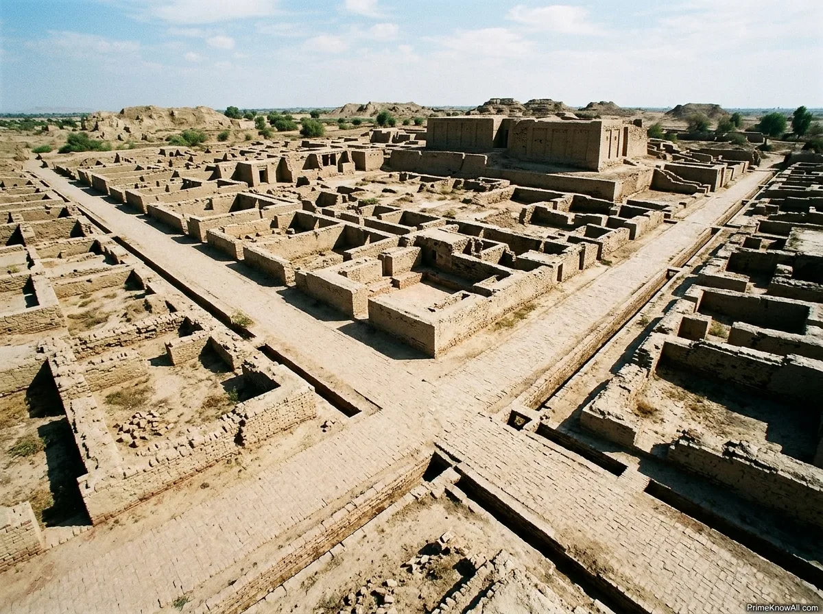
An orthogonal grid is a street layout where roads meet close to right angles. Several Indus cities used this idea in practical ways. Straight streets made it easier to divide blocks, move carts, place drains, and rebuild after floods or repairs.
A citadel, in Indus archaeology, usually means a raised and often walled sector of a settlement. It does not always mean a palace or royal fortress. In many cases, it may have held public buildings, water structures, storage areas, or controlled spaces. The safer wording is raised civic sector, because the political meaning is still debated.
- Planning scale: from household bathrooms to citywide drainage routes.
- Planning material: baked brick, mud brick, stone, timber, bitumen, and packed earth.
- Planning goal: daily function, water handling, access, cleanliness, craft work, and resilience.
Why Indus Cities Still Feel Modern
Indus cities feel modern because their most visible achievements are not tombs or victory walls, but systems people still care about today: clean water, drainage, street order, flood risk, and durable materials. A visitor looking at Mohenjo-daro or Dholavira is really looking at old answers to very familiar urban problems.
Many ancient cities grew in messy layers around temples, palaces, markets, or defensive walls. Indus settlements often show another pattern. The basic urban services seem to have been planned early, then repaired, extended, and reused. This is one reason the Indus Valley is often discussed beside Egypt and Mesopotamia, even though its public architecture looks far less royal.
The easiest comparison is a modern apartment block. The part people notice first may be the façade, but the building only works because of pipes, vents, stairs, drains, access corridors, load-bearing walls, and service routes. Indus planning worked in a similar hidden way: the city’s intelligence was often inside the street, under the floor, beside the well, or behind the brick-lined drain.
Small note for the reader:
- The Indus achievement was mostly civic, not royal.
- Its best evidence comes from streets, drains, bricks, wells, and settlement layout.
- The absence of clear palaces does not mean the cities lacked authority; it means the form of authority is still hard to prove.
Main Planning Features Across Indus Cities
The main features of Indus city planning include grid-like streets, raised sectors, lower residential areas, brick-lined drains, wells, bathrooms, standardized bricks, craft zones, city walls, and water-storage systems. Not every city had all of them in the same form, which is exactly why the Indus system is more interesting than a simple “grid city” label.
| Planning Feature | Where It Appears | What It Did | Why It Matters |
|---|---|---|---|
| Grid-Like Streets | Mohenjo-daro, Harappa, Kalibangan, parts of other sites | Organized blocks and movement | Helped carts, pedestrians, drainage lines, and rebuilding |
| Covered Drains | Mohenjo-daro, Harappa, Rakhigarhi, other excavated areas | Moved wastewater away from houses and streets | Shows civic attention to sanitation and maintenance |
| Brick-Lined Wells | Especially Mohenjo-daro; also other sites in different numbers | Supplied water close to homes and neighborhoods | Reduced dependence on one riverbank or one central tank |
| Standard Brick Ratio | Many Harappan sites | Used repeatable proportions such as 1:2:4 | Made walls, drains, wells, and platforms easier to build consistently |
| Raised Platforms | Mohenjo-daro, Harappa, Dholavira | Lifted important sectors above surrounding ground | May have helped with flood risk, status, or public control |
| Reservoirs And Water Harvesting | Dholavira, Lothal, some regional sites | Stored or managed scarce and seasonal water | Shows adaptation to dry zones, tides, and shifting water sources |
The table also shows why the Indus Valley should not be described with one narrow phrase. “Grid planning” is only part of the story. A street grid without drains, wells, and reliable materials would not explain why these cities worked for many generations.
A Short Definition Of Civic Standardization
Civic standardization means using shared measurements, materials, layouts, or construction habits so that different builders can produce compatible urban parts. In the Indus case, the best-known example is the 1:2:4 brick proportion, often described as height:width:length, or 4:2:1 when read as length:width:height.
- For walls: standard bricks made bonding easier.
- For drains: repeatable brick sizes helped channels keep form.
- For wells: wedge-like arrangements of bricks could support circular shafts.
- For repairs: similar sizes made replacement more manageable.
Mohenjo-Daro And The Logic Of Water
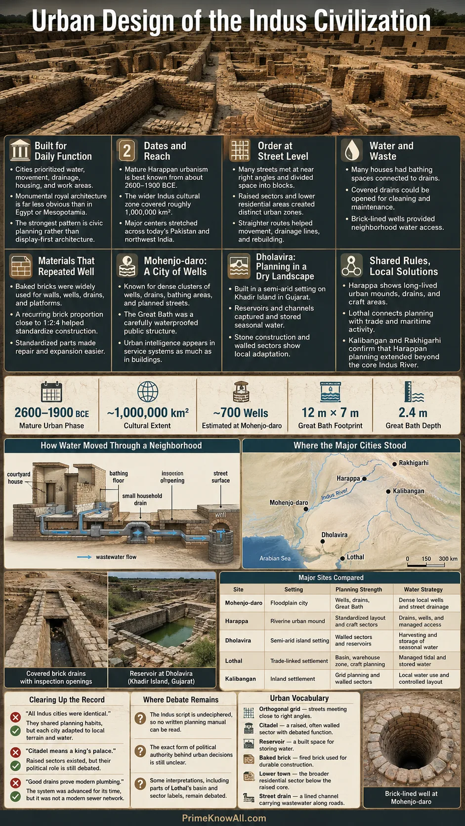
Mohenjo-daro shows Indus planning at a large urban scale. Its raised western mound, lower town, streets, drains, wells, bathing spaces, and public structures suggest a city designed around water access and water removal as much as around movement.
The site is often called a city of wells. Archaeologists have estimated that Mohenjo-daro may have had more than 700 wells, though the exact figure depends on excavation, survival, and interpretation. Even with caution, the pattern is clear: water was not treated as a rare public luxury. It was built into the urban fabric.
Many houses had bathing areas, and wastewater could pass through small drains into larger street drains. Some drains were covered with brick or stone slabs that could be lifted for cleaning. That detail matters. A drain is not only a channel; it is a maintenance system when people can open it, clear it, and keep it working.
The Great Bath As Planned Public Space
The Great Bath at Mohenjo-daro is one of the most discussed Indus structures. It was a large tank built with careful brickwork and waterproofing. Its exact use remains debated, but it was clearly not a casual household feature. It points to a planned public or group activity where water, access, and controlled space mattered.
The safest reading is not “temple,” because that would go beyond the evidence. A better reading is this: the Great Bath shows that Indus builders could plan a structure where water, architecture, and shared ritual or civic use came together in one controlled place.
What this section gives you:
- Mohenjo-daro’s planning was deeply tied to water supply and drainage.
- Covered drains suggest not only design, but also repair access.
- The Great Bath should be described carefully because its exact meaning is still not settled.
Dholavira And Planning For A Dry Landscape
Dholavira changes the way the Indus story should be told. It was built on Khadir island in today’s Gujarat, in a dry setting where water had to be captured, stored, and routed with care. Its planning shows that Harappan urbanism was not limited to riverbank cities with brick drains.
Dholavira used stone more visibly than many other Harappan sites and had a planned arrangement often described through sectors such as the castle, bailey, middle town, lower town, ceremonial ground, reservoirs, gateways, and cemetery. This does not mean every label is fully understood. It does mean the city was divided into controlled spaces with different roles.
The city’s reservoirs are especially important. A reservoir is a storage area designed to hold water for later use. At Dholavira, water management was not a side feature. It shaped the city’s survival. Two seasonal streams helped supply the settlement, but the urban design had to make seasonal water last.
Why Dholavira Matters For The Bigger Picture
Dholavira reminds readers that Indus planning was flexible. The same civilization could build brick-heavy drainage networks at Mohenjo-daro and large water-harvesting systems at Dholavira. Shared standards did not erase local solutions.
- Arid setting: planning had to reduce water loss.
- Fortified sectors: walls and gates shaped movement and access.
- Reservoir system: storage was part of urban planning, not an afterthought.
- Material choice: stone use shows adaptation to local resources.
Harappa, Kalibangan, Rakhigarhi, And Lothal
The Indus planning tradition becomes clearer when more sites are compared. Mohenjo-daro and Dholavira are famous, but Harappa, Kalibangan, Rakhigarhi, and Lothal show how the same urban habits appeared in different landscapes and economic settings.
Harappa
Harappa gave the civilization one of its common names: Harappan. Excavations show mounds, walls, drains, craft areas, standardized materials, and long occupational layers. The site also helps scholars track how Indus settlement grew, changed, and declined over time.
Kalibangan
Kalibangan, in today’s Rajasthan, is often discussed for its grid layout and early settlement evidence. It helps show that Indus planning was not limited to the Indus River itself. The broader Harappan zone included the Ghaggar-Hakra region, Gujarat, Punjab, Sindh, Haryana, Rajasthan, and nearby areas.
Rakhigarhi
Rakhigarhi, in Haryana, has become central to public discussion because it is among the largest known Harappan sites in India. Official descriptions note multiple mounds, planned township features, mud-brick and burnt-brick houses, and drainage. New work around the site continues to refine what scholars can say about its layout.
Lothal
Lothal, in Gujarat, shows how planning could support trade and production. It is often described as a Harappan port-town, with a basin, inlet and outlet features, a warehouse area, bead-making evidence, and links toward the Gulf region. Some interpretations of its basin have been debated, so careful wording is useful: the site provides strong evidence for a planned settlement connected to maritime and craft activity.
Pause point:
- Indus planning was not one fixed blueprint.
- Each city adjusted to water source, terrain, trade role, and local material.
- The shared pattern is best seen in repeated habits, not in identical city maps.
How The Planning System Worked
The Indus planning system worked through linked decisions. Streets shaped blocks. Blocks shaped houses. Houses connected to drains. Drains needed slopes, covers, and outlets. Wells needed safe lining. Bricks needed repeatable sizes. The city was a chain of practical choices.
1. Choose A Safe Settlement Area
Builders looked for access to water, trade routes, workable ground, and enough space for expansion.
2. Raise Or Protect Important Sectors
Platforms, walls, and mounds helped separate public areas, manage floods, and control access.
3. Lay Out Streets And Blocks
Straighter roads made movement, drainage, and neighborhood division easier to manage.
4. Build Houses Around Daily Needs
Many homes included courtyards, bathing spaces, storage, and access to drains or wells.
5. Move Wastewater Away
Small household drains could feed into larger street drains, often covered for safety and cleaning.
6. Keep The System Repairable
Repeatable bricks, accessible covers