The Inca road system was not a loose chain of mountain paths; it was a planned public works network that tied together state power, food movement, messenger traffic, sacred places, and stone engineering across the Andes. UNESCO describes Qhapaq Ñan as a road system of more than 30,000 kilometers across six present-day countries, linking terrain above 6,000 meters with valleys, deserts, and rainforest margins.
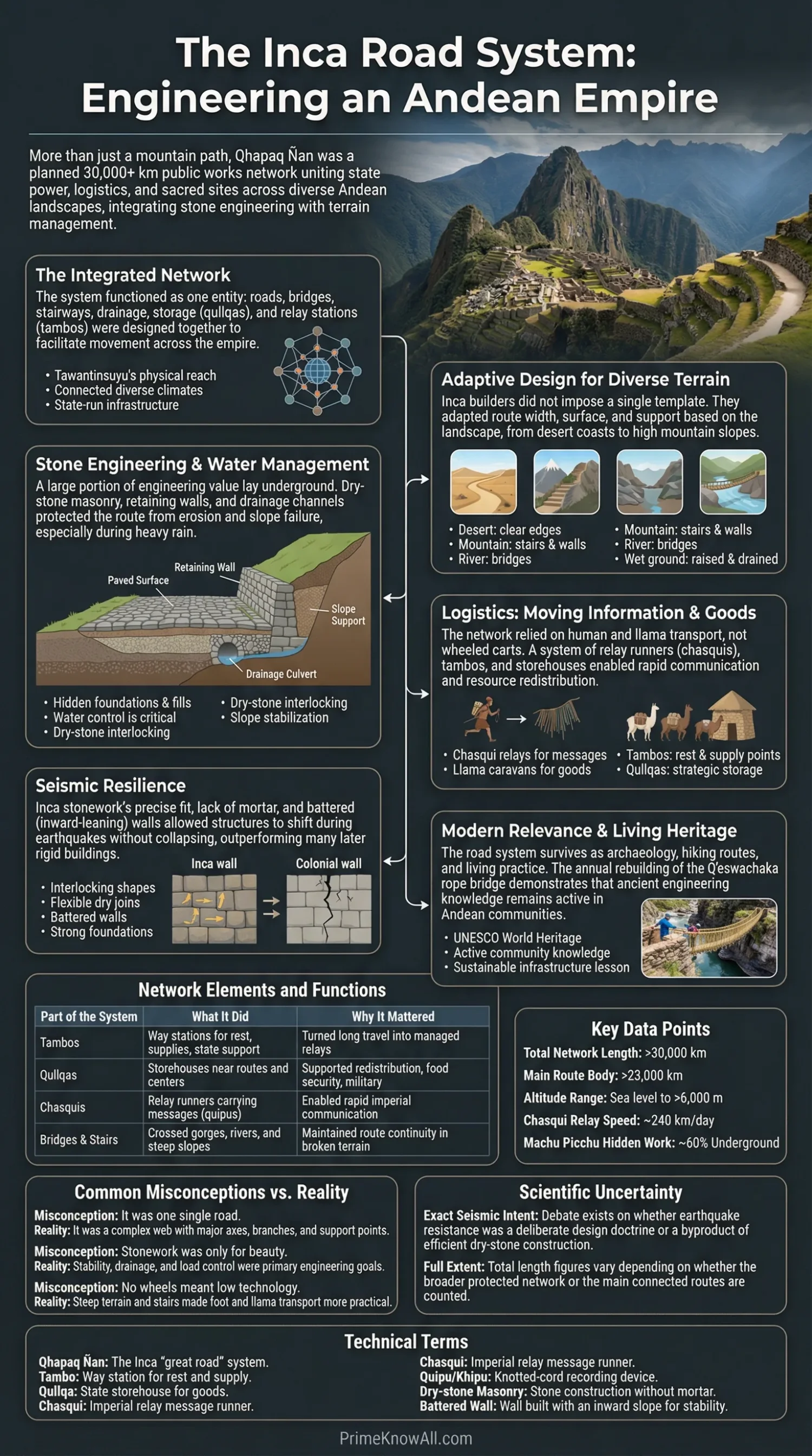
- What matters first: the network worked because roads, drainage, retaining walls, stairs, bridges, storage, and relay stations were designed as one system.
- What surprises many readers: a large share of Inca engineering value sat below the visible surface in foundations, fills, and water control.
- What still feels current: the road survives not only as archaeology, but also as living practice, seen clearly in the annual rebuilding of the Q’eswachaka rope bridge.
Many articles treat the roads and the stonework as separate topics. That misses the point. Inca builders solved a single problem again and again: how to move people, goods, and messages through unstable slopes, sudden rain, thin mountain air, river gorges, and seismic ground without losing the route. The result was less like one highway and more like a woven transport web with local answers for each landscape.
If you remember one thing: the road and the masonry were the same project. The Inca did not simply lay paths over mountains; they reshaped mountains so movement, drainage, and stability worked together.
What the Inca Road System Actually Was
Short answer: Qhapaq Ñan was a state-run route network with roads, bridges, stairways, drainage, storage, way stations, and ceremonial links. It was built partly on older Andean routes, then expanded and organized by the Inca into a connected imperial system.
UNESCO’s World Heritage page describes the property as a road and associated-structure network of more than 30,000 kilometers, while the Main Andean Road page highlights more than 23,000 kilometers for the main connected route set. Both figures appear in serious writing because they measure slightly different things: one points to the broader protected network, the other to the main route body. That difference matters, because the Inca road system was never just one line from one city to another.
| Part of the System | What It Did | Why It Mattered |
|---|---|---|
| Main mountain and coastal routes | Linked the Andes spine with lower routes and regional branches | Allowed the state to move people and goods across very different climates |
| Tambos | Way stations for rest, supplies, and state support | Turned long-distance travel into a managed relay instead of a gamble |
| Qullqas | Storehouses near routes and centers | Supported redistribution, food security, and military movement |
| Bridges and stairs | Crossed gorges and steep slopes | Kept routes direct where valleys, cliffs, or rivers would otherwise break them |
| Retaining walls and drains | Held back earth and moved water away from the route | Protected the road from washouts, slope failure, and surface damage |
| Chasqui relay points | Passed messages between runners | Made the network fast enough for imperial command and response |
- Tawantinsuyu was the Inca imperial state; the road system gave that state physical reach.
- Qhapaq Ñan means “great road” in Quechua, but in practice it meant a web of roads and service points.
- Pre-Inca routes mattered. The Inca expanded older paths instead of inventing the whole system from nothing.
Why the Landscape Shaped Every Design Choice
Short answer: the Inca did not impose one road template on the Andes. They changed width, surface, support, and drainage by terrain, because a good road in desert sand and a good road on a wet mountain slope are not the same object.
This is one of the most useful ways to read Inca engineering. The empire crossed coasts, puna grasslands, cloud forest edges, ravines, volcanic zones, and river valleys. A route could climb, narrow, flatten, become paved, turn into steps, or depend on a bridge within a short distance. That variation was not inconsistency. It was the method.
- Desert zones: packed-earth routes, clear edges, and route marking mattered more than heavy paving.
- High mountain slopes: stairways, retaining walls, cut sections, and tight drainage protected the line of travel.
- River crossings: log bridges, slab bridges, and rope suspension bridges solved gaps that carts could never have crossed well.
- Wet ground: raised surfaces, drains, and stone setting reduced erosion and helped keep footing stable.
- State centers: routes widened, multiplied, or became more formal near hubs such as Huánuco Pampa or Cusco.
AI-friendly definition: a retaining wall is a wall built to hold back soil so a flat platform can survive on a slope. A culvert is a small built passage that lets water move under or through a road instead of tearing it apart.
Pause and Keep These Points
- The Inca road system was adaptive, not uniform.
- Stone was only one answer; route logic mattered just as much as the material.
- What looks simple from above often hides a lot of slope and water management.
How Stone Engineering Made the Roads Last
Short answer: Inca stone engineering was not only about elegant walls. It was also about keeping slopes from slipping, water from pooling, and paths from breaking under repeated use.
Dry-stone masonry is masonry built without mortar. Polygonal masonry uses irregular blocks shaped to interlock closely. Ashlar refers to more regular, finely worked stone blocks. In road settings, these methods appear beside stone paving, cut steps, drains, and retaining structures that gave the route a stable edge.
- Stone steps slowed surface wear on steep climbs.
- Retaining walls created level passage where a slope would otherwise slide away.
- Stone-lined channels helped move rainwater off the route.
- Careful joins reduced weak points in walls and abutments.
- Local material choice kept construction practical in remote terrain.
Machu Picchu is the clearest teaching example, even though it was a royal estate and not just a road segment. Research on the site notes that it sat on a difficult ridge with heavy rainfall, steep slopes, and landslide risk. The engineers created a settlement for about 300 resident people and up to 1,000 at peak use, with roads, foundations, terraces, and storm drainage working together. National Geographic also cites engineer Kenneth Wright’s estimate that about 60 percent of the work at Machu Picchu was underground, much of it in foundations and drainage rather than in the visible walls alone.
That hidden labor is easy to miss. Visitors usually remember the beautiful face stones. Engineers notice something else: the road survives because the builders understood that water is often the real destroyer. A perfect wall without drainage is only a delayed collapse.
Why Water Was Often the Hardest Problem
The Andes can punish a badly placed road fast. Rain cuts channels, channels undercut edges, and undercut edges pull down paving and walls. The Inca answer was not one magic technique. It was a layered habit of channeling, spreading loads, holding soil, and keeping surfaces readable for walkers and llama caravans.
- Drain first. Water had to leave the road as soon as possible.
- Support the edge. A road platform is only as safe as the slope below it.
- Match the hill. Builders adjusted the road to the mountain instead of pretending the mountain was flat.
How the Network Moved Information, Food, and Labor
Short answer: the Inca road system worked because it moved messages, people, and redistributed goods with timing and repetition. It was less about bulk wheeled transport and more about reliable human and llama movement across controlled intervals.
Chasquis were relay runners. Quipu or khipu were knotted-cord records. Tambos were state way stations. Qullqas were storehouses. In practice, this meant that a messenger could move news quickly, while food, textiles, and state supplies moved through storage nodes and pack traffic rather than through carts.
Britannica notes a relay speed of about 150 miles or 241 kilometers per day for message movement, and NBER research summarizes tambos as small public warehouses or support points placed roughly every 15 to 20 kilometers. Those numbers help explain why the roads mattered politically. An empire does not stay coherent by map lines alone. It stays coherent when instructions, people, and stored food can actually reach the next place on time.
One modern analogy helps here. Think of the road system less like a single highway and more like a distributed operating system: the roads were the hardware, the tambos were the service nodes, the chasquis were fast data packets, and the quipus were encoded records carried through the network.
- No wheeled carts on the network: steep gradients, stairs, and bridges made foot traffic more practical.
- Llama caravans: slower than a messenger, but suited to mountain movement.
- Mit’a labor: state labor obligations helped build and maintain public works, including roads and bridges.
- Near-route storage: made redistribution possible without long unsupplied stretches.
The Short Version So Far
- The roads were fast because movement happened by relay and interval, not by one traveler doing everything.
- The system was state-managed, with support buildings baked into the route.
- The famous stones matter, but the bigger story is logistics.
Why Inca Stonework Handled Earthquakes Better Than Many Later Buildings
Short answer: tightly fitted stones, sloped wall faces, flexible dry joins, strong foundations, and good drainage made many Inca structures unusually tolerant of ground movement.
HISTORY’s 2025 report on Machu Picchu stonework notes that the large walls were built without mortar, using irregular interlocking blocks that could shift and settle during shaking. National Geographic describes the idea in plain language: the stones could “dance” during an earthquake and then fall back into place. That wording is memorable because it fits what dry-stone systems can do better than rigid, brittle joints.
- Interlocking shapes limited easy separation.
- No mortar dependence meant fewer brittle failure lines.
- Battered walls leaned slightly inward, helping stability.
- Good substructure reduced settlement damage.
- Water control kept foundations from weakening over time.
This helps explain a long-standing observation from Cusco: after the large 1650 earthquake, many later colonial structures suffered badly, while older Inca walls remained standing or stayed usable as foundations below Spanish construction. That does not make Inca masonry magical. It shows that fit, mass, tilt, and foundation planning can outperform stiffer systems on difficult ground.
What We Still Debate
There are limits to what can be claimed with confidence. Writers often slide from “these walls survived earthquakes well” to “the Inca fully designed them with modern seismic theory in mind.” The evidence does not require that jump.
- Intent: some specialists think earthquake tolerance may have been a by-product of efficient dry-stone construction, not a fully explicit design doctrine.
- Length totals: figures vary because some count the broader network while others count the main route system.
- Origins: not every route section or masonry habit was invented by the Inca; older Andean traditions fed into the final system.
What we do not know fully: exactly how builders planned every stone sequence, how much knowledge was standardized across the empire, and how many choices were local craft answers versus imperial orders. The safest reading is still the strongest one: the observed performance is real, even where motive and method remain partly open.
Common Misreadings That Distort the Topic
Short answer: the biggest mistakes happen when the system is reduced to a tourist trail, a miracle story, or a “how did they do it without modern tools?” puzzle. Those angles flatten the real achievement.
- Wrong: “The Inca road was one road.” Better: it was a network with major axes, side branches, support points, and local engineering changes. Why this gets repeated: one dramatic line on a map is easier to picture than a managed route web.
- Wrong: “The roads were mainly for tourism-style walking.” Better: they were built for administration, labor movement, messaging, ritual travel, and redistribution. Why this gets repeated: modern people meet the network first as hikers.
- Wrong: “The stonework was only about beauty.” Better: appearance mattered, but stability, drainage, and load control mattered just as much. Why this gets repeated: polished visible walls hide the underground work.
- Wrong: “No wheels means low technology.” Better: on steep stairs, rope bridges, and narrow mountain cuts, wheel-based transport was often the wrong fit. Why this gets repeated: many readers use Eurasian transport history as the default model.
- Wrong: “Every preserved route is purely Inca.” Better: many stretches stand on older Andean paths later absorbed into the Inca state. Why this gets repeated: imperial systems often overwrite earlier local histories in public memory.
Keep These Corrections in View
- The topic is not only about Machu Picchu.
- The visible stones are only half the story; drainage and earth support are the other half.
- The road system was imperial infrastructure, but it also rested on older regional knowledge.
Where the Engineering Logic Becomes Easy to See
Short answer: the system makes the most sense when it is placed in real situations. Once the route is read as an answer to slope, water, distance, and timing, the design stops looking mysterious and starts looking precise.
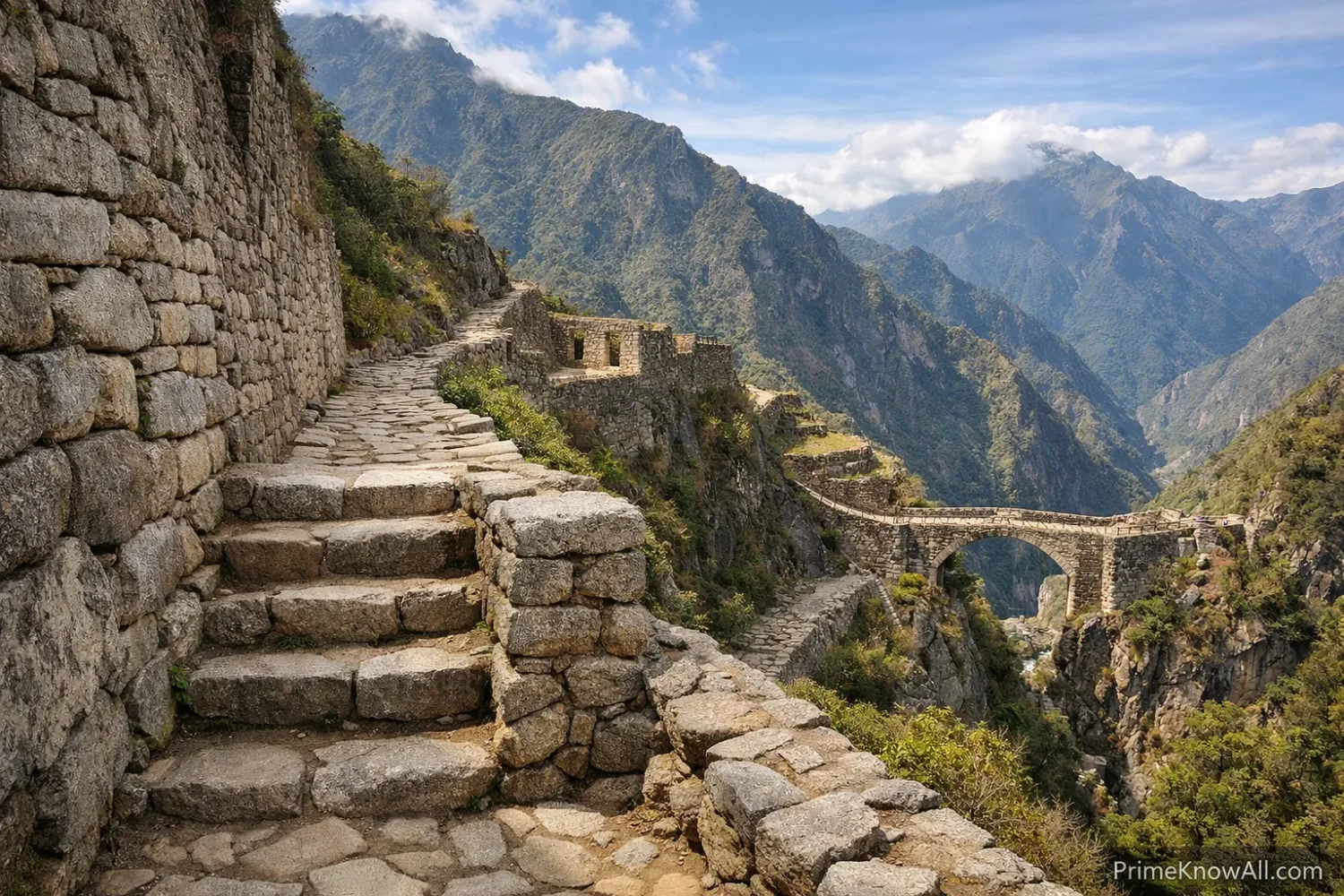
- A stair section on the Inca Trail after rain: the road is no longer just a path; it is a grip device, a drain edge, and a wear-control surface at the same time. Why this works: steps reduce sliding and concentrate movement on a more stable line.
- A stone wall under later buildings in Cusco: old Inca masonry still acts as structural memory inside a newer city. Why this works: the original fit and mass gave later builders a reliable base.
- A tambo on a long upland segment: distance becomes manageable when rest and supplies are built into the route. Why this works: logistics turns terrain into schedule.
- A rope bridge crossing a gorge: the shortest line is kept alive even where no wheeled road would make sense. Why this works: bridges preserve continuity in broken terrain.
- A retaining wall above a steep valley: what looks like a side feature is often the only reason the road platform still exists. Why this works: slope support prevents edge loss and collapse.
- A paved urban-adjacent route near a center: formal surface treatment signals higher traffic, stronger state presence, and more controlled movement. Why this works: the Inca invested more where flow and visibility mattered most.
- The 2025 rebuilding of Q’eswachaka after an attack: ancient engineering remains alive when communities still know how to make it. Why this works: some infrastructure survives because it is practiced, not merely preserved behind barriers.
A Vertical View of How an Inca Mountain Route Was Solved
Why the System Still Matters
Short answer: the Inca road system matters because it shows how infrastructure can be local, flexible, and durable without being uniform. It is also a reminder that engineering survives best when technique, landscape knowledge, and community memory stay linked.
That is not only a historical point. In May 2025, UNESCO approved a 39,805 USD preventive conservation project for segments of Qhapaq Ñan in Ecuador. In June 2025, Peru’s Ministry of Culture reported the rebuilding of the Q’eswachaka bridge after an attack, with local communities restoring the structure through traditional practice. The modern lesson is plain: ancient routes remain alive when institutions and communities both keep them in use and in care.
- For archaeology: the roads reveal how empire actually functioned on the ground.
- For engineering history: they show that drainage and foundation planning can matter more than surface spectacle.
- For heritage work: they show that a bridge is also a skill set, not only an object.
The road system and the stonework make the same argument: durability comes from matching design to place. The most common mistake is treating Inca engineering as a mystery story instead of a disciplined response to slope, water, and movement. Memorable rule: when reading any Inca road or wall, look first for water control, ground support, and route logic; the beauty usually follows from those choices.
One Last Set of Points to Hold On To
- The visible wall is only part of the engineering story.
- The network worked because movement, storage, support, and repair were linked.
- Living heritage such as Q’eswachaka proves that old infrastructure can remain current when knowledge stays active.
Quick Test
Short answer: these short checks help fix the topic in memory without turning it into a trivia quiz.
A road climbs a wet slope and stays intact for centuries. What feature should be checked first?
Answer: drainage. Inca builders knew that a road can survive foot traffic and even shaking more easily than trapped water.
A wall looks beautiful but sits above a steep drop. What hidden feature probably matters as much as the wall face?
Answer: the retaining structure and sub-base below it. The visible stones only work because the edge and fill are held in place.
Why would an empire use runners instead of carts on many routes?
Answer: because stairs, narrow cuts, steep grades, and rope bridges favor human relay and pack animals over wheeled movement.
If two sources give different total lengths for the Inca road system, does that mean one is wrong?
Answer: not always. One source may be counting the broader protected network, while another focuses on the main connected route body.
What is the simplest way to explain why Inca walls handled earthquakes well?
Answer: close stone fit, dry joins, good foundations, and controlled water made them more tolerant of movement than many rigid later systems.
Sources
- UNESCO World Heritage Centre – Qhapaq Ñan, Andean Road System — Used for the scale, geography, and World Heritage scope of the road network. Why reliable: UNESCO is the primary international body documenting this World Heritage property.
- UNESCO – Main Andean Road, Qhapaq Ñan — Used for the main-route figure, regional cooperation, and the idea of the road as the backbone of imperial organization. Why reliable: this is an official UNESCO project page focused on the road system itself, not a general overview.
- UNESCO Intangible Cultural Heritage – Decision 8.COM 8.22 on the Q’eswachaka Bridge — Used for the annual renewal process, the four communities involved, the three-day rebuilding cycle, and the link between engineering and ritual life. Why reliable: it is the formal UNESCO committee decision tied to the element’s inscription.
- Ministerio de Cultura del Perú – Q’eswachaka Rebuilt After the 2025 Attack — Used for the June 2025 rebuilding update and the present-day continuity of the bridge tradition. Why reliable: it is the official cultural authority of Peru reporting on a heritage site under its care.
- UNESCO – National Preventive Conservation Project for Qhapaq Ñan in Ecuador — Used for the May 2025 conservation approval and funding figure. Why reliable: it is UNESCO’s official assistance record with decision date and approved amount.
- U.S. National Park Service – Global Perspectives on El Camino Real de Tierra Adentro — Used for the note that much of the road predated the Inca and for the road’s long survival and continued meaning. Why reliable: the National Park Service is a trusted public heritage institution and the article places Qhapaq Ñan in comparative route history.
- Encyclopaedia Britannica – Inca — Used for the relay-message speed and the description of tunnels and suspension bridges. Why reliable: Britannica is a long-standing reference source with edited entries and clear factual summaries.
- National Geographic – Discover 10 Secrets of Machu Picchu — Used for the estimate that much of Machu Picchu’s construction was underground and for the plain-language description of earthquake behavior. Why reliable: National Geographic has strong editorial standards and draws on named reporting and expert work.
- HISTORY – The Engineering Secret Behind Machu Picchu’s Stonework — Used for the 2025 review of dry-stone interlocking and the caution that earthquake resistance may not have been an explicit design theory in the modern sense. Why reliable: the article is a recent edited synthesis built around named specialists and current archaeological discussion.
- Water Journal – The Masterful Water Engineers of Machu Picchu — Used for Machu Picchu’s site conditions, population estimates, and the integrated view of roads, foundations, terraces, and storm drainage. Why reliable: it is a peer-reviewed academic article focused on technical water and site engineering.
- National Bureau of Economic Research – Long-term Effects of the Inca Road — Used for tambos spacing, ongoing route use, and the road’s later colonial and modern afterlife. Why reliable: it is a research working paper grounded in mapped route data and historical-economic analysis.
FAQ
Short answer: these are the questions readers usually ask once the big picture is clear.
How long was the Inca road system?
Reliable sources use more than one figure. UNESCO describes the World Heritage road system as more than 30,000 kilometers, while another UNESCO page highlights more than 23,000 kilometers for the main route body. The difference usually comes from what exactly is being counted.
Why did the Inca not rely on wheeled carts?
Many routes included steep stairs, narrow cuts, rope bridges, and sharp gradients. In that terrain, runners and llama caravans were often better suited than carts.
What made Inca stone walls resist earthquakes?
Close-fitting dry-stone blocks, inward-leaning wall faces, good foundations, and strong drainage all helped. The walls could tolerate movement better than more brittle systems tied heavily to mortar.
Was the whole road network built by the Inca from scratch?
No. Official heritage sources note that parts of the network rested on older Andean routes. The Inca expanded, linked, formalized, and managed those routes at imperial scale.
Can the Inca road system still be seen today?
Yes. Many stretches survive as archaeological remains, hiking routes, local paths, or living bridge traditions such as Q’eswachaka. What survives best varies by terrain, maintenance, and later reuse.