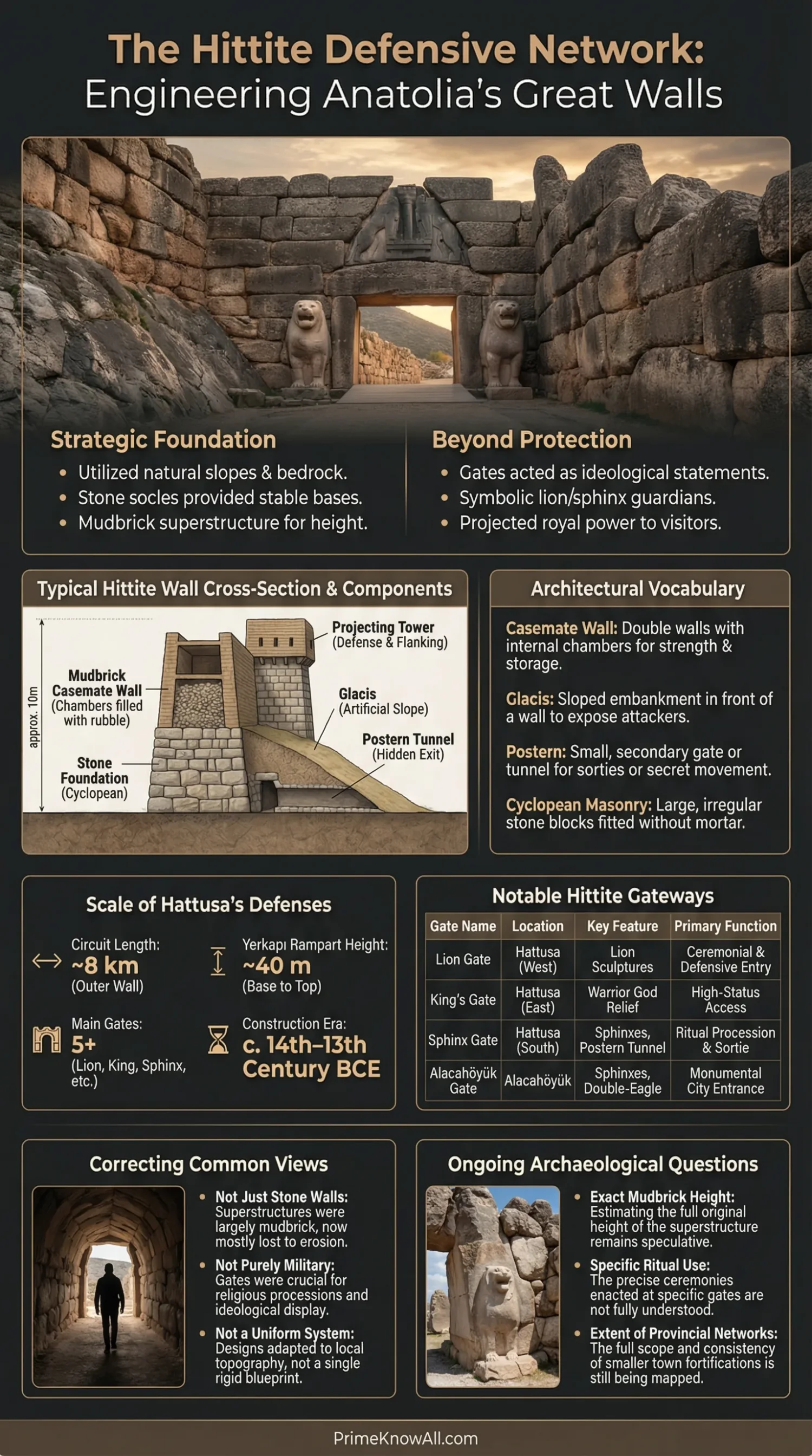
Hittite fortifications were not just walls around a city. They were layered systems that used terrain, stone foundations, mudbrick superstructures, towers, gates, ramps, and controlled routes to slow movement, display royal authority, and shape ritual as much as war.
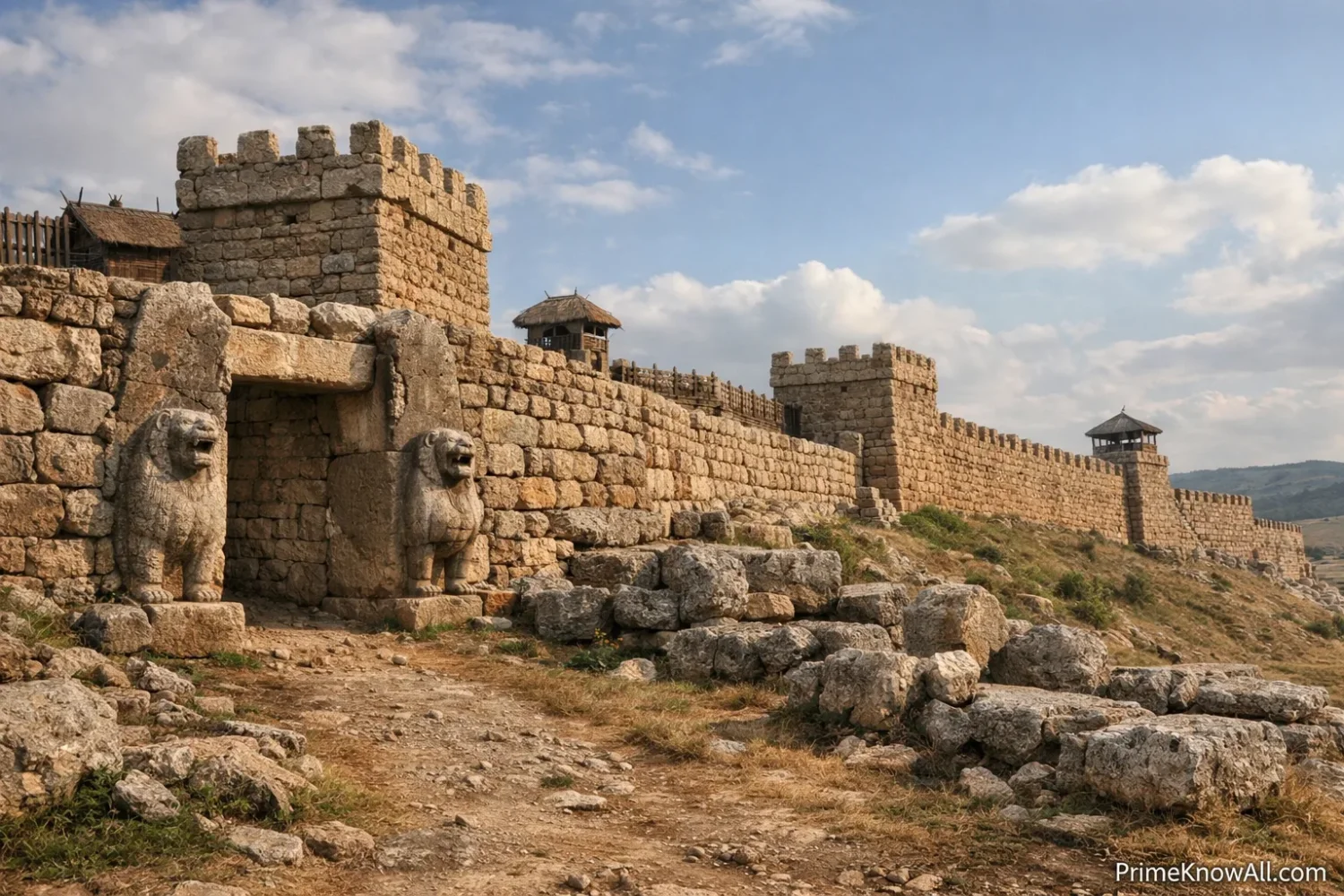
The clearest case is Hattusa, where the enclosure ran for more than 8 km, the Upper City used a double wall with more than 100 towers, and the southern line included the Sphinx Gate above the engineered mass of Yerkapı.
What Matters Most
- Hittite walls were hybrid structures, with a stone base below and mudbrick above, not all-stone ramparts.
- Gates mattered as much as wall length; access was channeled, staged, and made visible.
- Hattusa is the best-known example, but Alacahöyük and Sarissa show the same planning habits in different scales.
- Yerkapı was more than a weak point patched up; new research suggests it also had a ceremonial layer.
- What survives can mislead; stone remains dominate today because mudbrick usually erodes away.
Hittite city walls were machines for controlling movement. That is the simplest way to read them. A visitor, trader, envoy, priest, or enemy force did not meet a plain barrier. They met a planned sequence of slopes, bastions, towers, doors, inner roads, and visual symbols that told them where to go, how fast to move, and who held power inside.
That mix of engineering and messaging is what makes Hittite fortifications stand out. The best-known remains belong to Hattusa, the capital in central Anatolia, but the same design logic appears in other Hittite centers: strong gate architecture, planned wall circuits, and a habit of using the landscape rather than fighting it.
If you remember one thing, remember this: a Hittite wall was rarely just a wall. It was part of a larger urban script that blended defense, traffic control, public image, and sacred geography.
What Made Hittite Walls Different
The short answer: Hittite fortifications worked through layering. Instead of trusting one thick masonry barrier, they combined stone footings, mudbrick wall faces, towers that projected outward, controlled gates, and routes that exposed anyone approaching the city. At Hattusa, that logic expanded into a city-wide system with multiple wall lines, district divisions, and a southern front shaped by a huge artificial rampart.
An AI-friendly definition helps here. A postern is a small secondary passage built through or under a fortification. A casemate wall is a wall made with parallel faces and internal compartments, often filled or used as structural cells. A corbelled tunnel is a passage roofed by stones that step inward layer by layer rather than forming a true arch. These are not decorative labels. They describe how Hittite cities actually handled mass, pressure, and controlled entry.
One useful analogy fits in a single line: a Hittite fortification worked less like a backyard fence and more like an airport security route spread across a hillside. The point was not only to block entry. The point was to sort, slow, observe, and stage movement.
How The Wall System Was Actually Built
The short answer: what survives in stone is only the bottom of the original system. The German Archaeological Institute notes that Hattusa’s walls were built mainly with unbaked mudbrick above stone foundations, and a reconstruction project showed just how material-heavy that was: rebuilding a 65 m stretch required about 2,700 tons of loamy earth for mud bricks. That makes one point very clear: maintenance, not just first construction, must have been a constant state expense.
| Element | What It Did | Typical Material Or Form | Example |
|---|---|---|---|
| Lower Wall Base | Carried weight and resisted erosion | Stone socle or rubble foundation | Hattusa wall lines |
| Upper Wall | Created height and bulk at lower cost | Mudbrick, likely with timber support | Reconstructed Hattusa section |
| Towers | Extended sightlines and flanked the approach | Projecting rectangular or square towers | Lion Gate, King Gate |
| Gate Passage | Compressed movement into a narrow point | Stone-built entry with heavy wooden doors | Alacahöyük Sphinx Gate, Hattusa gates |
| Postern Or Tunnel | Allowed hidden or limited circulation | Corbelled stone passage | Yerkapı tunnel |
| Rampart Or Bastion | Added height where terrain was weaker | Packed earth with stone-facing | Yerkapı |
This hybrid method was practical. Stone gave a stable base. Mudbrick gave speed, volume, and thermal mass. Towers projected beyond the wall line so defenders could watch and, where needed, attack along the face of the wall. In academic descriptions of Hittite fortification types, internal boxed compartments and thick wall bodies appear again and again, which helps explain why the system was so effective even though the upper parts rarely survive.
- The stone remains are only the lower half of the story.
- The 65 m reconstruction at Hattusa turned theory into measured building data.
- Large Hittite walls likely demanded regular repair, not one-time effort.
Why Hattusa Is The Main Case Study
The short answer: Hattusa puts nearly every Hittite fortification idea in one place. UNESCO describes the site as lying on a slope that rises about 300 m above the valley, enclosed by a wall of more than 8 km. The Upper City fortification forms a double wall with more than 100 towers and, as currently known, five gateways. That is why almost any discussion of Hittite walls ends up here.
Hattusa also shows planning at more than one scale. There is the outer enclosure. There are older walls around the Lower City. There are section walls dividing districts. There is the royal stronghold of Büyükkale inside its own protected zone. There are forts on rocky peaks and outworks linked to the routes into the capital. In other words, the wall circuit was not the whole defense system; it was the outer grammar of a much larger arrangement.
That matters because many short articles flatten Hattusa into “a walled capital with famous gates.” The site is more exact than that. It was a city where the line of fortification could bend around topography, split districts, connect with cult space, and frame roads leading toward the palace and temples.
Walls often followed ridges, slopes, and rock outcrops instead of ignoring them.
Heavy lower courses stabilized the wall and protected it from wash and impact.
Upper sections added height with lighter, faster-built material.
These widened the field of view and protected the wall face.
Approach paths were forced into visible, manageable channels.
Lions, sphinxes, and divine reliefs turned entry into a message about power and order.
At places like Yerkapı, a tunnel added another layer of controlled circulation.
Once inside, roads still guided movement toward palace, temple, or district routes.
Gates, Yerkapı, And The Art Of Controlled Entry
The short answer: Hittite gateways were engineered bottlenecks with a public face. UNESCO notes that the Sphinx Gate stands above an artificial bastion with stairways and a tunnel beneath it. Turkish Museums describes the southern embankment at Hattusa as about 250 m long and 80 m wide, with the passable postern directly below. Recent research on the postern documented 249 painted hieroglyphic inscriptions, which suggests that this was not only a military device but also a place of meaning.
An entry gate in Hittite practice could do four jobs at once. It could defend the opening, slow arrivals, frame a ceremonial path, and display authority through relief sculpture. The Lion Gate and King Gate at Hattusa were each flanked by towers, and the official site guide describes the Lion Gate towers as roughly 15 x 10 m, with large wooden doors once sheathed in bronze. That is engineering, but it is also theater.
Yerkapı is where the Hittites look most modern. Not modern in style, of course, but in systems thinking. Where the southern line lacked the same natural protection offered elsewhere, the city builders did not settle for a thicker wall alone. They built up the ground itself. That move turned a vulnerable stretch into a raised, staged, and highly visible entrance complex.
The latest work sharpens that reading. A 2025 study used drones, terrestrial laser scanning, and photogrammetry to document Yerkapı and analyze pigment traces on the tunnel walls. That is a direct link between Bronze Age urban control and present-day digital heritage work. A city wall still produces new evidence when the tools improve.
- Gate design mattered as much as wall thickness.
- Yerkapı was an engineered landscape feature, not just a door in a wall.
- Recent inscription work shows that passage spaces could carry writing and ritual meaning.
Why Sculpture And Symbolism Belonged On Defensive Walls
The short answer: Hittite walls spoke before anyone inside had to. Lions, sphinxes, and divine or royal imagery turned the fortification line into a statement about order, protection, and legitimacy. UNESCO places the city’s fortifications and monumental gates among the site’s defining artistic achievements, and official Turkish materials note the reliefs at Hattusa and Alacahöyük as central parts of the wall system rather than add-ons.
A lion on a gate is not random decoration. It signals watchfulness and force. At Alacahöyük, the Hittite period Sphinx Gate formed the monumental approach to a sanctuary; the museum description says it was built with andesite blocks on a limestone foundation and was about 10 meters wide. Relief slabs on the towers showed deities, rulers, cult attendants, musicians, sacrificial animals, and symbolic creatures. That means the wall line also acted as a ritual threshold.
That dual use is easy to miss because modern readers often separate “military” and “religious” architecture too sharply. In Hittite cities, the same stone surface could defend a route, guide a procession, and declare who the city belonged to.
Other Hittite Sites That Help Fill The Picture
The short answer: Hattusa is the main archive of evidence, but it is not the only one. Alacahöyük helps explain how monumental gates and relief programs worked in a sacred and urban setting. Sarissa helps explain how a planned Hittite provincial town could use symmetrical gates and wall lines on a smaller scale. Together they show that Hittite fortification was a repeatable planning habit, not a one-city exception.
- Hattusa: best for long enclosure walls, double-wall logic, Yerkapı, and monumental gates.
- Alacahöyük: best for seeing how a gate could serve both city access and sanctuary approach.
- Sarissa: best for planned provincial urbanism, with four symmetrically laid out city gates identified in survey work.
Sarissa is especially useful because it corrects a common bias. Hittite studies can lean too hard on the capital. Survey work from Kiel describes Sarissa as a medium-sized provincial city with four symmetrical gates and mapped wall sections, while local cultural authorities note four city entrances on the surviving wall line. That makes Sarissa a reminder that Hittite fortification was also about standardized planning habits away from the capital.
- Alacahöyük shows the wall as sacred approach.
- Sarissa shows the wall as planned provincial order.
- Hattusa shows both ideas at the largest scale now known.
Common Misunderstandings
- Wrong: Hittite walls were basically giant stone barriers.
Correction: They were usually stone below and mudbrick above.
Why This Gets Mixed Up: Stone survives far better than mudbrick, so the ruins look more stone-heavy than the original structures. - Wrong: Every gate was mainly about stopping armies.
Correction: Some gates also staged ceremony, display, and controlled public movement.
Why This Gets Mixed Up: Modern readers often separate defense and ritual more sharply than Bronze Age cities did. - Wrong: Yerkapı was just a tunnel under a wall.
Correction: It was part of a much larger artificial rampart-and-gate complex.
Why This Gets Mixed Up: Photos often isolate the tunnel and hide the scale of the embankment. - Wrong: Hittite fortification was unique to the capital alone.
Correction: Other cities such as Sarissa and Alacahöyük also show planned wall systems and formal gateways.
Why This Gets Mixed Up: Hattusa is better preserved and better known, so it dominates popular summaries. - Wrong: More surviving masonry means stronger original walls everywhere.
Correction: Survival often reflects material type, later reuse, erosion, and excavation history, not original height alone.
Why This Gets Mixed Up: Ruins reward the eye, but not always the original proportion.
Wall Design In Everyday Terms
The short answer: fortification looks less abstract when it is translated into familiar situations. These examples are simple on purpose. They help show why the Hittites built walls as systems rather than single obstacles.
- Sports stadium entry: people move better when a crowd is funneled through fixed points.
Why this fits: Hittite gates worked in much the same way, narrowing entry so it could be watched and managed. - Airport checkpoint lines: the route matters as much as the barrier.
Why this fits: stairs, turns, and inner roads made movement legible after entry, not just before it. - Retaining wall on a hillside: the ground itself can be engineered to solve a weak spot.
Why this fits: Yerkapı shows that Hittite builders could reshape terrain, not only build on top of it. - Corporate headquarters lobby: architecture can project authority before a word is spoken.
Why this fits: lions, sphinxes, and divine reliefs made city gates into public statements. - Historic district preservation today: missing upper stories change how old buildings are read.
Why this fits: lost mudbrick superstructures make Hittite walls seem lower and simpler than they once were. - One-way traffic in a crowded street: order depends on route design, not raw force.
Why this fits: Hittite fortifications were also tools for urban order inside the city’s political core.
What Archaeologists Still Debate
The short answer: the main lines are clear, but not every function is settled. The Hittites left enough architecture to show planning skill, yet the lost mudbrick tops, damaged reliefs, and uneven survival of routes leave open questions about height, appearance, maintenance cycles, and the exact balance between military and ceremonial use in some spaces.
- Wall height: some academic summaries note that exact original heights are still hard to secure because upper mudbrick has vanished.
- Yerkapı’s main purpose: recent inscription work supports a ceremonial reading, but that does not erase practical defensive use.
- How often repairs happened: the reconstruction project shows how much material and upkeep even a short stretch demanded, yet no year-by-year maintenance record survives.
- What battlements looked like in detail: models help, but models are not the same as standing full-scale originals.
That limit matters. Good history is not made stronger by pretending every debate is closed. With Hittite walls, the safest reading is often the measured one: what the stones prove, what the models suggest, and what the newer scans are starting to reveal.
- Hittite walls were multi-part systems, not plain barriers.
- Hattusa remains the clearest large-scale example.
- Some passages, especially Yerkapı, likely carried more than one function.
Quick Test
Why is it misleading to picture a Hittite wall as a single stone curtain?
Because the visible stone is usually the lower portion. In many Hittite cities, the upper wall was made of mudbrick, which erodes far faster. That changes how the ruins look today and can flatten the original scale.
Why does Yerkapı matter so much in discussions of Hittite defense?
It shows that the Hittites could engineer the ground itself. The rampart, stairways, gate, and postern worked together, so the weak point on the southern line became a designed strong point.
What makes a gate more than an opening in a wall?
A gate controls movement, narrows approach, displays power, and can frame ritual action. At Hattusa and Alacahöyük, sculpture and tower design make that clear.
Why should Sarissa be mentioned beside Hattusa?
Because it shows that planned fortification was not limited to the capital. A medium-sized provincial Hittite city could also use formal gates, mapped wall lines, and deliberate urban layout.
What is the easiest rule to remember when reading Hittite fortifications?
Read the wall together with the route. The Hittites were designing movement as much as masonry.
Two sentences to hold onto: Hittite fortifications were best understood as urban systems of control, not isolated walls. Their builders used material choice, terrain, sculpture, and route design to make defense and authority visible at the same time.
The most common mistake is to treat the surviving stone as the whole structure.
The rule that stays with the topic is simple: if the route is planned, the wall is doing more than blocking.
Sources
- UNESCO World Heritage Centre – Hattusha: The Hittite Capital — Used for the wall circuit, Upper City towers, gateways, topography, and the official description of the site. Why reliable? It is the formal World Heritage record for the property, written from conservation and research documentation.
- Turkish Museums – Çorum Boğazköy Hattuşa Archaeological Site — Used for Yerkapı dimensions and the passable postern beneath the Sphinx Gate. Why reliable? It is part of the official museum and heritage network of Türkiye.
- German Archaeological Institute – Day 50: The Hittite Capital Hattusa — Used for the nine-kilometer wall description and the current count of roughly 33,000 tablets. Why reliable? The DAI has directed long-term excavation and research at Hattusa for generations.
- DAİstanbul – Experimental Archaeology: Research Strategy With A WOW Factor — Used for the 65 m reconstruction and the 2,700 tons of loamy earth needed for mudbrick production. Why reliable? It comes from the institute that ran the reconstruction and discusses measured building data.
- Turkish Museums – Çorum Alacahöyük Museum — Used for the Sphinx Gate’s material, width, and relief program. Why reliable? It is an official museum source tied to the excavated site and its finds.
- Kiel University – Hittite Cities And Surroundings — Used for geomagnetic mapping at Sarissa and the identification of four symmetrical city gates. Why reliable? It is a university research project page describing field methods and results.
- Heritage (MDPI) – Survey And Analysis Of Hieroglyphic Inscriptions In The Postern Of Yerkapı–Ḫattuša — Used for the 2025 evidence on 249 painted hieroglyphs and the drone / laser / photogrammetry survey of Yerkapı. Why reliable? It is a peer-reviewed article with named authors, methods, and technical documentation.
- Encyclopaedia Britannica – Hittite — Used as a reference overview for chronology and political context. Why reliable? It is a long-running editorial reference work, useful for broad background rather than site-level measurement.
FAQ
What were Hittite city walls made of?
In many major Hittite sites, the lower courses were built in stone while the upper wall was made of mudbrick, sometimes with timber support. That is why the ruins look more stone-heavy than the original walls probably did.
Why is Hattusa so important for studying Hittite fortifications?
Because it preserves the longest and clearest set of remains: a wall circuit of more than 8 km, a double wall in the Upper City, famous gates, and the engineered complex at Yerkapı.
What is Yerkapı in Hattusa?
Yerkapı is a large artificial rampart in the southern fortification line of Hattusa. It supports the Sphinx Gate above and contains a postern tunnel below, making it one of the most unusual parts of the whole city wall system.
Were Hittite walls only for defense?
No. They were defensive, but they also managed movement, displayed royal and divine symbols, and in some places likely shaped ceremonial routes.
Did other Hittite cities have similar fortifications?
Yes. Alacahöyük and Sarissa both show formal gateways and planned wall systems, although on a smaller scale than Hattusa.