Etruscan cities were planned as living systems, not just clusters of houses. In the clearest cases, street order, ritual space, work areas, water control, and burial landscapes were shaped together, which is why Etruscan urban design still feels strikingly readable today.
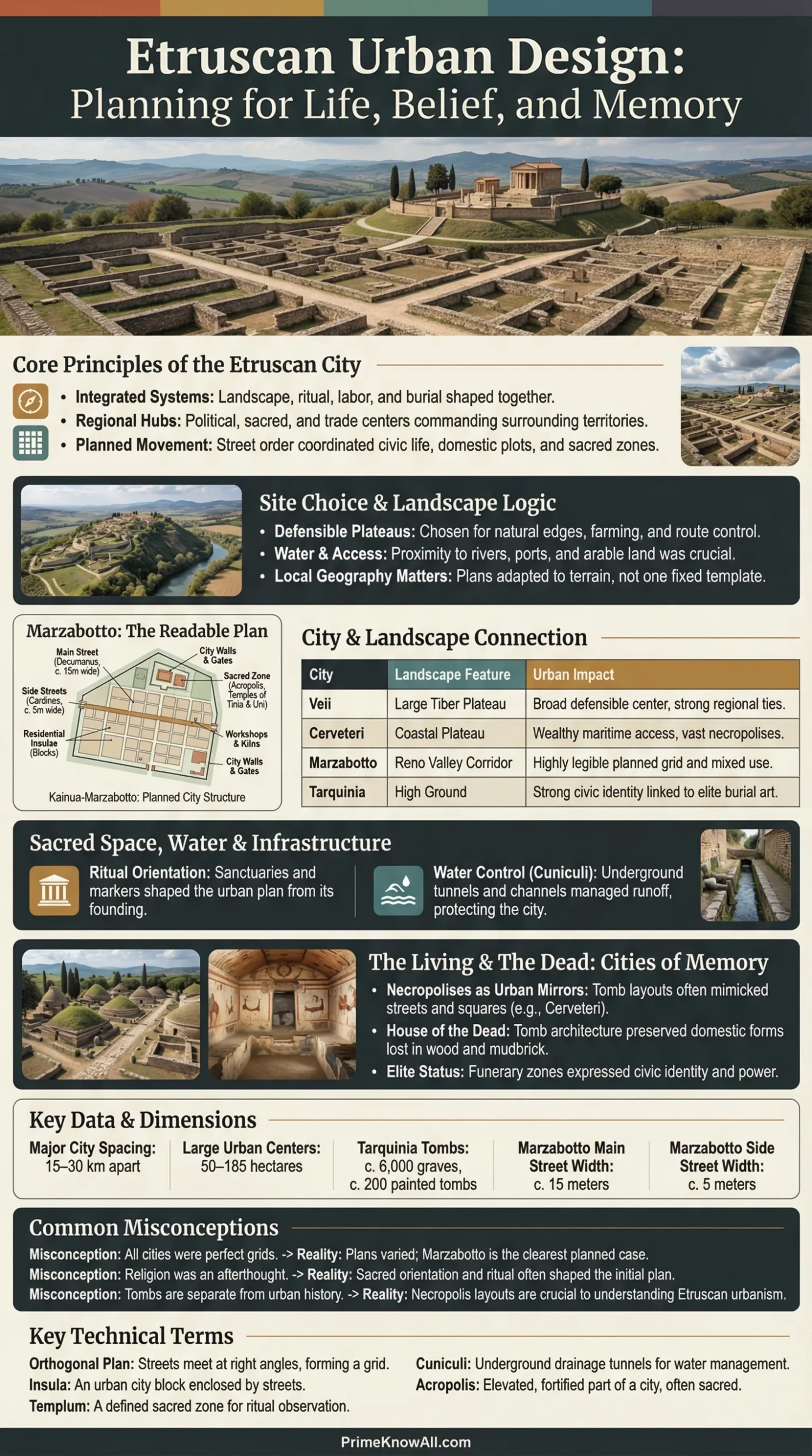
A city in Etruria was more than a walled place. It was a political center, a sacred landscape, a trade node, and a map of social order. The best evidence comes from sites such as Marzabotto, Cerveteri, Tarquinia, and Tuscania, where archaeology makes the urban logic visible even when texts stay thin.
If You Remember One Thing… the Etruscan city worked by linking landscape, belief, movement, labor, and memory. A grid could matter, but the whole urban system mattered more.
What to Notice First
- Not every Etruscan city used a perfect grid. The neatest examples are only one part of the story.
- Marzabotto is the clearest planning case. Its streets, blocks, sanctuaries, workshops, and cemeteries can still be traced.
- Necropolises belong inside the urban discussion. At Cerveteri, tombs are arranged like neighborhoods, streets, and small squares.
- Ritual mattered in practical planning. Surveying, orientation, and sacred boundaries were tied to civic order.
- The countryside was part of the city. Etruscan centers drew food, labor, and status from a managed hinterland.
What Made an Etruscan City a City
An Etruscan city was defined by scale, coordination, and reach. Archaeological work suggests that in the early Iron Age, smaller dispersed sites of about 2–3 hectares, and at times up to 15 hectares, gave way to much larger proto-urban centers on plateaus measuring roughly 50–185 hectares. By the Orientalizing and Archaic periods, these became competing city-states, with major centers spaced at about 15–30 km from one another across Etruria.
Etruscan urbanism did not mean one fixed template. Some places were dominant and long-lived. Others were smaller or more fragile. That matters because it stops the topic from collapsing into a single tidy diagram. What survives in stone can look orderly; what shaped daily life was often more layered.
- Scale: the center stood above nearby villages and farms.
- Coordination: housing, cult space, movement routes, and burial grounds formed a linked plan.
- Reach: the city organized land, craft work, exchange, and civic identity beyond its core.
How Site Choice Shaped the Plan
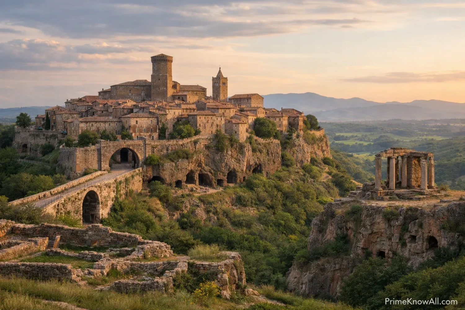
The Etruscans did not place cities on neutral ground. They chose plateaus, tuff ridges, river corridors, and coastal positions that could support defense, farming, ritual display, and trade at the same time. A city plan started with the land itself.
That is why Veii and Cerveteri feel different from Populonia or Marzabotto. The urban rules overlap, yet each site answers a different landscape problem. One controls a plateau near inland routes. Another looks toward the sea. Another sits in an Apennine corridor where movement through a valley matters as much as monumentality.
- Defensible height: plateaus and spurs created a natural edge before walls were added or strengthened.
- Access to food and water: nearby arable land mattered as much as ceremonial space.
- Control of routes: roads, river passages, ports, and valley links turned cities into regional hubs.
| Site | Landscape Advantage | What It Meant for Urban Design |
|---|---|---|
| Veii | Large plateau near the Tiber system | A broad defensible center with room for expansion, route control, and strong ties to nearby territory. |
| Cerveteri (Caere) | Plateau close to the coast and linked to Pyrgi | A wealthy inland city with maritime access, elite tomb zones, and a strong ceremonial landscape. |
| Tarquinia | High ground with coastal connections | A city where urban identity, elite display, and funerary art became tightly linked. |
| Populonia | Coastal position near metal resources | An urban center shaped by trade, industry, and seaborne exchange. |
| Marzabotto (Kainua) | Plateau in the Reno valley corridor | A planned city whose street system, sanctuaries, workshops, and cemeteries remain unusually legible. |
Pause Here
- Urban design began with terrain. The site was part of the plan, not a backdrop.
- Etruscan cities were regional engines. Their power came from what they controlled around them.
- One city model does not fit all cases. Local geography kept reshaping urban form.
Street Plans, Blocks, and Movement
When an Etruscan city used a regular plan, the order was deliberate. At sites like Marzabotto, the street system was not a rough convenience. It organized movement, building plots, sacred zones, and civic visibility. The best current evidence points to main streets about 15 meters wide and secondary streets about 5 meters wide, creating elongated blocks that housed both dwellings and work areas.
A Few Terms That Help
- Orthogonal plan means a layout in which streets meet at right angles.
- Axial symmetry means the plan gives extra weight to one or more main lines of movement or sight.
- Insula means an urban block enclosed by streets.
- Templum, in ritual language, means a defined sacred zone for orientation and observation, not just a temple building.
One trap is to assume that a neat grid proves a purely technical mindset. It does not. In Etruria, measurement and meaning could occupy the same line on the ground. A street could carry carts, shape a procession, and mark civic order all at once.
Sacred Space Was Part of the Plan
Etruscan urban design cannot be read well if religion is pushed to the side. At Kainua-Marzabotto, official local and university evidence points to a founded city whose plan was tied to ritual acts, including a central marker stone with a cross sign and the placement of major sanctuaries dedicated to Tinia and Uni. The city was not laid out first and sacralized later as an afterthought. The sacred order helped shape the urban order.
This is one place where Etruscan planning feels closer to a charter than to a casual building phase. A modern analogy helps: think of a new civic district where the survey lines, public square, zoning rules, and ceremonial site are approved in one act. That does not make the city abstract. It makes the city intentional.
- Acropolis zones gave elevation and visibility to cult activity.
- Urban sanctuaries could sit inside the block system, not far outside it.
- Orientation mattered because belief and space were read together.
| Site | Best Evidence | What Urban Designers Learn From It |
|---|---|---|
| Marzabotto | Preserved street grid, blocks, sanctuaries, workshops, cemeteries | How a planned Etruscan city could coordinate movement, ritual, labor, and plot division. |
| Cerveteri | Banditaccia necropolis with streets, squares, and house-like tombs | How burial landscapes mirrored urban logic and domestic form. |
| Tarquinia | Monterozzi tombs, painted interiors, elite funerary zones | How memory, status, and civic identity were staged beyond the residential core. |
| Tuscania | Survey data across town and countryside | How city power depended on farms, minor centers, and a managed rural ring. |
What This Adds Up To
- The grid is only part of the story. Sacred geography helped decide where order began.
- Etruscan planning was not purely borrowed. Outside influence mattered, yet local ritual logic reshaped it.
- Urban design worked on two levels at once. It solved movement problems and expressed civic belief.
How an Etruscan City Held Together
A vertical read from terrain to memory.
1. Large New Centers
Early Iron Age smaller sites gave way to larger plateau centers of about 50–185 hectares.
2. A Spaced Urban Network
Major Etruscan centers appear in a fairly even pattern, often about 15–30 km apart.
3. Street Hierarchy
At Marzabotto, 15 m main streets and 5 m side streets organized elongated urban blocks.
4. Sacred Orientation
A central marked stone and major sanctuaries show that surveying and ritual were tied together.
5. Water Control
Etruscan builders used channelization and cuniculi, underground drainage tunnels, to keep land and routes workable.
6. Memory Outside the Core
Cerveteri has thousands of tombs in a city-like layout; Tarquinia has 6,000 graves and about 200 painted tombs.
Houses, Workshops, and Daily Use
Etruscan cities were built for living and making, not just for ceremony. Excavated evidence from Marzabotto points to dwellings, workshops, ceramic production, and even a foundry inside the urban fabric. That mixed pattern matters. It shows that the city block was not a frozen monument. It was a working unit.
That detail is easy to miss because surviving temples and tombs draw more attention than house plots. Yet cities stand or fall on repeated routines: carrying water, firing pottery, storing food, repairing roofs, moving goods to a market, or reaching a sanctuary on a festival day. Current discussion about walkable neighborhoods can make this easier to picture. Etruscan planners were not chasing a modern slogan, but they did shape districts where daily distance mattered.
- Domestic space: houses were planned within blocks, not scattered at random.
- Craft space: urban production sat close to where people lived and moved.
- Civic rhythm: roads connected ordinary labor to public and sacred life.
Water, Drainage, and Street Maintenance
A city plan fails fast if water is left out. The Etruscans were not known for aqueducts in the Roman sense, yet archaeological and engineering scholarship points to real skill in drainage tunnels, or cuniculi, as well as local water channelization systems. At Marzabotto, official site descriptions mention water channelization among the settled features on the plateau.
This matters more than it first appears. Drainage protects roads, fields, slopes, and house foundations. In upland and plateau settings, bad runoff can undo the logic of a neat street plan very quickly. So when Roman engineering later expanded sewer and drainage work on a far larger scale, it did not start from nowhere.
- Cuniculi were underground channels used to remove excess water.
- Street durability depended on keeping runoff under control.
- Urban order included invisible infrastructure, not only visible monuments.
Before Moving On
- Mixed-use was real. Homes, craft work, movement, and ritual sat close together in some excavated quarters.
- Infrastructure matters. A city is not just what stands above ground.
- Etruscan planning feels modern in one narrow sense: it paid attention to distance, access, and repeated daily use.
The Living City and the City of the Dead
One of the best ways to understand Etruscan urban design is to study its cemeteries. That sounds odd at first, yet it is true. At Banditaccia in Cerveteri, thousands of tombs are arranged in a city-like plan with streets, small squares, and neighborhoods. At Tarquinia, the Monterozzi necropolis contains about 6,000 graves and roughly 200 painted tombs. These places preserve ideas about housing, status, kinship, and memory that the residential city often no longer keeps.
Why Tomb Plans Matter for Urban History
- House-like tomb interiors preserve forms of domestic architecture otherwise lost in wood and mudbrick.
- Street-based burial layouts show that ordered planning extended beyond the inhabited core.
- Family display reveals how elite identity shaped space across generations.
The deeper point is this: an Etruscan city was not just where the living slept and traded. It also included where the dead were placed, remembered, and symbolically housed. That urban mindset is one of the clearest parts of the Etruscan legacy.
Why Marzabotto Matters So Much
Marzabotto matters because it lets the plan stay visible. The city was founded near the end of the 6th century BCE and was abandoned in the 4th century BCE. Its preserved layout allows archaeologists to trace roads, insulae, houses, workshops, temples, and necropolises in relation to one another instead of guessing from scattered fragments.
That is why Marzabotto appears so often in modern discussions of Etruscan planning. It is not simply famous. It is readable. The city shows a wide north-south axis, three east-west roads, minor roads defining narrow blocks, sacred sectors, and burial areas to the east and north. Even the name Kainua, meaning new city, fits the planned feel of the place.
- Date range: late 6th to 4th century BCE.
- Urban clarity: preserved street hierarchy and block division.
- Interpretive value: one site where ritual, craft, housing, and infrastructure can be studied together.
A Simple Rule
- Marzabotto shows the plan.
- Cerveteri shows memory laid out like a city.
- Tarquinia shows status and belief painted into funerary space.
Common Misreadings
- Wrong: Every Etruscan city followed a perfect grid.
Correct: Some did, some did not. Marzabotto is a clear planned case, not a blanket model.
Why the mix-up happens: The neatest excavated sites are easier to teach and illustrate. - Wrong: Etruscan planning was a simple copy of Greek planning.
Correct: Greek influence mattered, yet ritual orientation, local terrain, and Etruscan civic practice changed the result.
Why the mix-up happens: Straight streets look familiar, so local differences get flattened. - Wrong: Tombs belong to art history, not urban history.
Correct: At Cerveteri and Tarquinia, burial layouts are part of the urban story.
Why the mix-up happens: People separate the “city” from the “cemetery” too sharply. - Wrong: Religion only decorated the city after practical planning was done.
Correct: In places like Kainua, sacred logic helped shape the plan from the start.
Why the mix-up happens: Modern readers often split civic design and belief into different categories. - Wrong: Rome invented all the useful urban techniques in central Italy.
Correct: Roman builders expanded earlier methods, yet Etruscan surveying, drainage, and civic ordering came first in many cases.
Why the mix-up happens: Roman evidence survives in greater volume and later texts are louder.
How This Looks in Everyday Life
- A potter leaves home and reaches a workshop inside the same block system. That works because housing and production were not always far apart.
- A funeral moves from the inhabited core toward an ordered necropolis. That matters because memory was planned, not improvised.
- Heavy rain hits a plateau settlement after a storm. Drainage and channelization matter because street order means little if water wins.
- A visitor enters through a gate and can read the wider routes first. Street hierarchy matters because main roads tell newcomers where civic life concentrates.
- A festival draws people toward a sanctuary linked to the urban plan. That matters because ritual movement depends on spatial order.
- Farm goods move from the countryside into the urban core. The city works because its food base sits beyond the walls or edges, not only within them.
- An elite family invests in a tomb built like a house. That matters because status is expressed through architecture in both life and death.
Limits of This Explanation
There are real limits to what can be said with confidence. First, survival is uneven. Timber, mudbrick, and roofing systems vanish faster than stone foundations. Second, Marzabotto is unusually legible, so it can pull interpretation too strongly toward planned regularity. Third, the written record is sparse, and much of what later readers know comes through non-Etruscan authors or much later interpretation.
That means a careful account should stay measured. It is fair to say that Etruscan cities show deliberate urban design. It is less fair to say that every detail of every city can now be reconstructed with equal certainty.
- What is clear: planned movement, sacred orientation, urban-rural links, and ordered necropolises.
- What stays patchy: exact house heights, street use in every period, and the full list of rules used in each city.
- What scholars still debate: how far one city model can stand for Etruria as a whole.
Quick Test
Which site gives the clearest picture of a planned Etruscan city?
Marzabotto, or Kainua, is the clearest case because its urban layout remains unusually visible, including roads, blocks, sacred areas, workshops, and cemeteries.
Did all Etruscan cities use a regular grid?
No. Some sites show strong orthogonal planning, while others developed in less regular ways shaped by terrain, power, and local history.
Why are necropolises so useful for understanding cities?
Because in Etruria, tombs can preserve house forms, street logic, and social ranking more clearly than the residential core.
What does “cuniculi” mean?
Cuniculi are underground drainage tunnels used to remove excess water, especially from land that needed to stay usable for farming or movement.
What is the most common reading mistake?
The most common mistake is to treat the grid as the whole city. In Etruria, the grid was only one layer within a larger system of ritual, labor, landscape, and memory.
Keep This Lens
Etruscan urban design worked best when land, streets, sanctuaries, workshops, and cemeteries supported one another. Marzabotto makes that structure visible; Cerveteri and Tarquinia show how memory and status extended it beyond the living core.
The mistake seen most often is reducing the subject to straight streets alone.
The rule worth keeping is simple: if a reading explains the roads but ignores ritual, water, and burial space, it is too small for an Etruscan city.
Sources
- University of Bologna – Marzabotto (Bologna): The Etruscan City of Kainua-Marzabotto — Used here for the city’s date range, excavated urban elements, temples, workshops, and necropolises. Why reliable: this is the excavation institution’s own research page, tied to long-running fieldwork.
- Appennino Bolognese – Kainua and the Archaeological Area — Used here for the central marker stone, broad north-south axis, three east-west roads, water channelization, and the east-north necropolis pattern. Why reliable: it is an official local public information page built around the archaeological site itself.
- UNESCO World Heritage Centre – Etruscan Necropolises of Cerveteri and Tarquinia — Used here for the city-like plan of Banditaccia, the 6,000 graves of Tarquinia, and the roughly 200 painted tombs. Why reliable: UNESCO publishes vetted heritage documentation with site-scale measurements and formal descriptions.
- MIT Press Open – Chapter 4: The Etruscan and Italic Cities — Used here for the ideas of orthogonality and axial symmetry in Etruscan-Italian planning. Why reliable: it is an academic press publication by a leading scholar of ancient town planning.
- Frontiers – Patterns of Etruscan Urbanism — Used here for the shift from smaller early sites to larger proto-urban centers, the 15–30 km spacing of major centers, and the idea that Etruscan urbanism took more than one form. Why reliable: it is a peer-reviewed research article built on settlement data and spatial analysis.
- Cambridge Core – Etruscan Urbanization, c. 700–300 bc — Used here for the Tuscania survey result showing a 6th-century BCE landscape with 219 sites, then decline to 129 sites later. Why reliable: it is a university press chapter by field archaeologists working directly on the region.
- PubMed Central – The Aqueducts and Water Supply of Ancient Rome — Used here for the point that the Etruscans had no aqueducts in the Roman sense but were skilled in cuniculi, underground drainage tunnels. Why reliable: it is an openly accessible scholarly article that cites standard engineering history.
- Britannica – Ancient Italic People — Used here for the traditional notice of the League of the Twelve Peoples and the annual meeting at the Fanum Voltumnae. Why reliable: Britannica is a long-standing reference work edited for factual clarity.
FAQ
What was the main idea behind Etruscan city planning?
The main idea was integration: cities joined site choice, street order, sacred orientation, work space, water management, and burial landscapes into one civic system.
Was Marzabotto a typical Etruscan city?
Not fully. It is the clearest planned case, which makes it very useful, yet it should not be treated as a perfect stand-in for every Etruscan city.
Why are Cerveteri and Tarquinia central to this topic?
Because their necropolises show that Etruscan urban thinking extended beyond the residential core. They preserve street logic, house imagery, and social memory in rare detail.
Did Etruscan planning influence Rome?
Yes, in part. Roman urbanism grew through many influences, yet Etruscan practices in surveying, ritual boundary-making, and drainage belong to that early central Italian background.
What does an orthogonal plan mean in simple terms?
It means the streets meet at right angles, creating blocks that are easier to divide, navigate, and build within.
Why should the countryside be part of the city story?
Because an Etruscan city depended on its farmland, minor settlements, and movement routes. The city center made little sense without its rural ring.