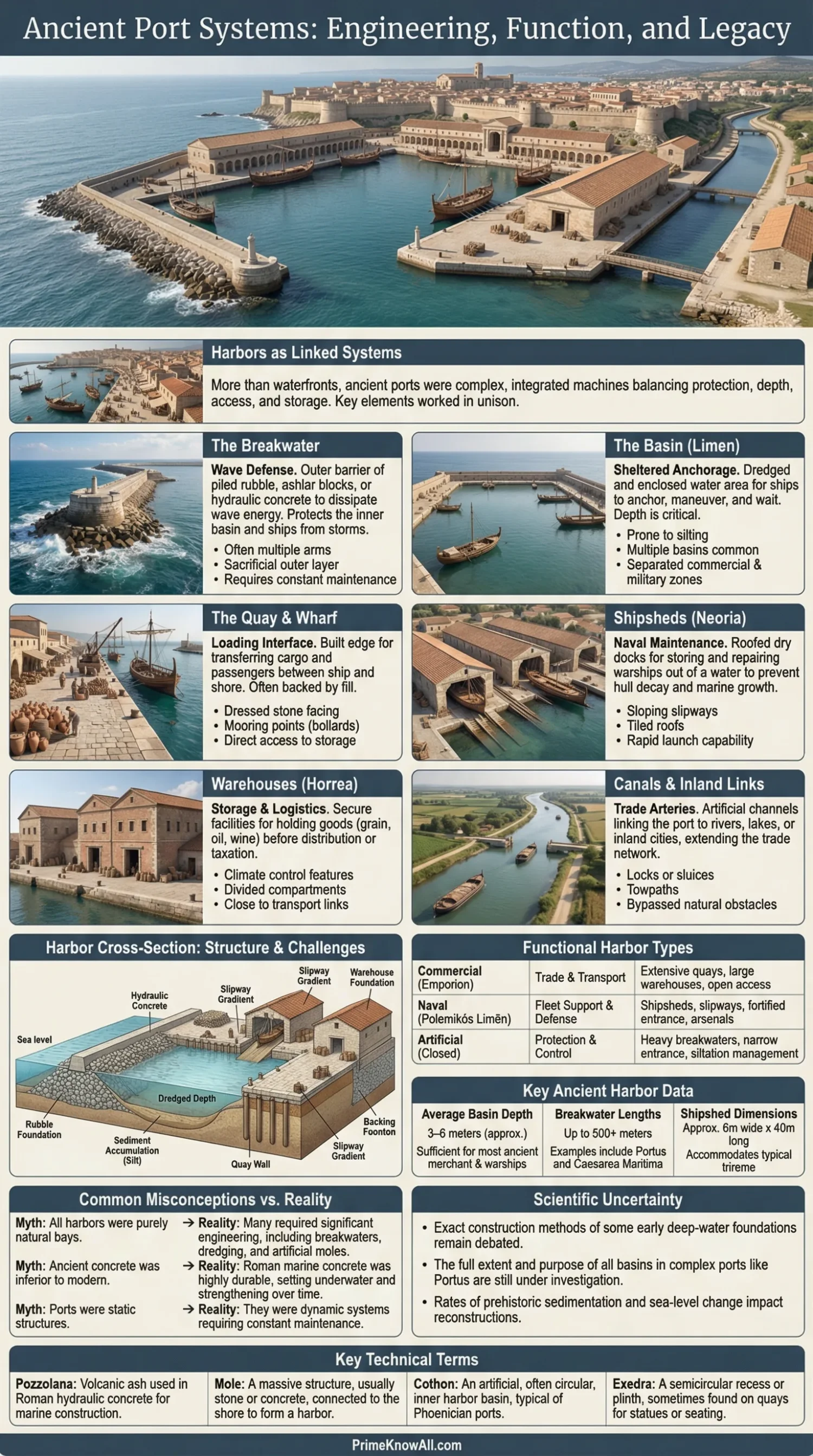
Ancient harbors were engineered shore zones built to solve three hard problems at once: protect ships from waves, move cargo and people fast, and keep a city tied to wider trade routes. A working port was never just water and stone; it was a linked system of basins, quays, breakwaters, warehouses, roads, canals, and control points.
- Most ancient ports used a mix of nature and engineering. Builders favored sheltered coves, then added moles, quays, ramps, slipways, and basin walls where the coast fell short.
- Depth mattered as much as walls. A harbor could look safe from shore and still fail if silt made it too shallow for loaded ships.
- Commercial and military needs often pulled design in different directions. Cargo ports wanted storage and access; naval ports wanted fast launch, repair space, and tighter control.
- Roman builders pushed open-sea harbor design much further. Hydraulic concrete let them build arms and foundations in places that earlier builders would usually avoid.
- Many ancient ports declined for practical reasons, not mystery. River shifts, silting, rising or falling relative sea level, storms, and costly upkeep could quietly end a harbor’s working life.
A harbor changed history long before it looked monumental. It turned a rough shoreline into a managed edge where grain, stone, timber, metals, pottery, taxes, crews, and ideas could all pass through the same narrow space. That is why ancient port structures matter so much: they show how societies organized movement, risk, labor, and storage at the exact point where land met sea.
If you remember one thing, remember this: an ancient harbor worked only when protection, depth, access, and maintenance stayed in balance. Beautiful masonry alone did not make a port useful.
What Ancient Harbors Were Meant to Do
The short answer is simple: ancient harbors were built to reduce uncertainty at the shoreline. A harbor gave ships a safer place to enter, pause, unload, repair, wait for weather, pay dues, and connect with inland transport.
- Shelter ships. Waves, surge, and cross-currents could break hulls or smash cargo even close to land.
- Create a controlled landing edge. A quay, meaning a built waterfront edge for loading and unloading, made transfer more orderly than an open beach.
- Store goods nearby. Grain, amphorae, timber, and stone needed dry, guarded spaces after arrival.
- Link sea routes to roads and rivers. Ports were transfer points, not isolated endpoints.
- Support state power. Some harbors fed capitals, some backed fleets, and many did both.
A harbor was less like a parking lot and more like an airport, seawall, warehouse district, and checkpoint folded into one shoreline. That is the best way to read ancient port remains. A basin without storage, roads, or repair space was only part of the story.
Main Parts of an Ancient Harbor
Most ancient ports used a repeatable kit of parts, even though the balance changed from place to place. Some sites leaned on natural shelter. Others needed heavy artificial works. Either way, the same design questions kept returning: How do ships enter? Where do they stop? Where does wave energy go? Where does cargo move next?
| Port Element | What It Did | Common Materials | Typical Problem |
|---|---|---|---|
| Breakwater | Reduced wave force before it reached the basin | Rubble, ashlar blocks, concrete, packed fill | Storm damage and scouring at the base |
| Mole | Artificial arm projecting into water to guide entry and add shelter | Stone blocks, rubble core, Roman concrete | Settlement, cracking, erosion at the head |
| Quay | Loading edge for cargo and passengers | Dressed stone, timber facing, fill behind wall | Wear from impact, rot, undermining |
| Basin | Provided enclosed water for anchoring and maneuvering | Excavated ground, lined edges, dredged floor | Silting and loss of depth |
| Slipway or Ramp | Allowed hauling boats ashore | Stone paving, packed earth, timber | Surface wear and poor traction |
| Shipshed | Roofed structure for storing warships out of water | Stone foundations, timber roof, tiled cover | Large upkeep cost and space demand |
| Warehouse | Held cargo before tax, sale, or redistribution | Brick, stone, mortar, timber floors | Fire, damp, theft, bottlenecks |
| Canal or Inner Link | Connected harbor water to river, town, or second basin | Excavated channel, revetments, embankments | Blockage, bank collapse, sediment build-up |
Pilots looked for known landmarks, headlands, towers, beacon fires, and the safest angle of entry.
A narrow gap between moles or natural rock reduced wave action but could also slow traffic and create queues.
Ships waited, turned, dropped anchor, or moved toward quays depending on depth, wind, and load.
Cargo moved by gangplank, ramp, basket, shoulder labor, cart, or animal power. Speed mattered because berth space was limited.
Goods passed into warehouses, tax points, counting yards, and redistribution zones near the waterfront.
Roads, rivers, canals, and urban markets turned a harbor from a landing place into a working economic system.
What Matters Up to This Point
- Protection without depth was not enough.
- Walls mattered, but circulation and storage mattered just as much.
- A port should be read as a system, not as a single monument.
How Engineers Built Safe Water Access
Ancient harbor building was a sequence of trade-offs, not a single trick. Builders first chose the least risky shoreline they could find, then added structure where nature stopped helping. The more exposed the coast, the more money, labor, and maintenance the harbor demanded.
- Site selection came first. A bay, headland, island screen, or river mouth could save huge labor.
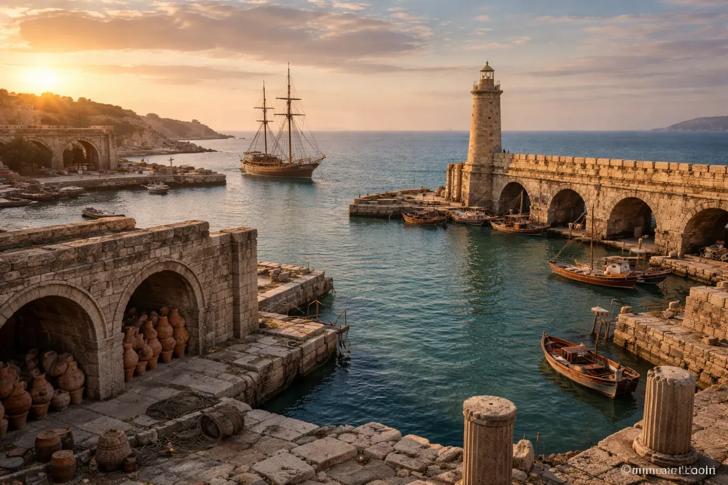
- Wave energy had to be broken. A breakwater is a protective barrier built to weaken incoming waves before they hit ships or harbor edges.
- Entry had to stay usable. Wide openings admitted swell; narrow openings improved shelter but slowed movement.
- Depth had to be preserved. Dredging means removing mud or sand from the basin floor so vessels can still float and turn.
- Loading zones had to stay stable. Quay faces needed backing fill, drainage, and constant repair.
Roman work at sea stands out because of hydraulic concrete. In plain terms, this was a lime-and-volcanic-ash mix that could set underwater when placed inside timber formwork with rubble aggregate. That changed the game. It let builders cast larger marine foundations instead of relying only on stacked stone. It also made open-sea projects more realistic, though never cheap or easy.
The hidden enemy was silt. Modern ports still spend heavily on dredging, and the old problem was the same. A harbor could keep its walls and still lose its job if the bottom rose year after year.
Why Greek, Phoenician, Roman, and Harappan Ports Looked Different
They looked different because they served different coasts, ship types, and political needs. There was no single ancient port formula. Harbor design shifted with local tide range, wave climate, river behavior, military pressure, cargo volume, and available building materials.
Harappan Port Planning
Lothal is the best-known South Asian case in this discussion because it ties basin design to tidal control, storage, and flood risk. Whether every scholar accepts every part of the old “dockyard” interpretation is another matter, but the site clearly shows that Bronze Age planners in the Indus sphere were thinking hard about water management, access, and trade handling.
Greek Naval Harbors
Greek port design often shows a sharper split between commercial and military priorities. In places like Piraeus, the harbor was not only a market edge. It was also fleet infrastructure. That is why shipsheds, meaning roofed slipways where warships could be stored and serviced out of the water, matter so much in Greek harbor archaeology.
Phoenician and Levantine Coastal Ports
Phoenician ports often made smart use of small natural pockets, offshore islets, and protected inlets. Their strength was not always giant masonry. It was the skill of fitting maritime activity to difficult coasts and long-distance exchange. In many Levantine settings, small changes in sediment, shoreline shape, or sea level could remake how the port worked.
Roman Imperial Ports
Roman ports tend to look more infrastructural because they were tied to scale. Once the state needed to move food, tax goods, military supplies, stone, timber, and luxury cargo for very large urban markets, the port had to become an extended logistics machine. That usually meant more basin control, more storage, more inland links, and more planned waterfront space.
- Where fleets mattered, slipways and shipsheds grew in value.
- Where bulk cargo mattered, quays, basins, and warehouses became heavier priorities.
- Where tides or flooding mattered, channels, spillways, and elevated walls became more visible in the design.
Hold This Picture
- Greek naval ports often read like fleet garages.
- Roman imperial ports often read like high-volume transfer zones.
- River-linked and tidal ports had to care about water behavior as much as stonework.
Harbor Examples Worth Knowing
A few sites explain the whole subject better than a long list ever could. Each one highlights a different harbor problem: tidal control, fleet storage, imperial supply, open-sea engineering, or long-term preservation.
Lothal
Lothal matters because it joins urban planning to a basin, wharf-like edge, and controlled water movement. The site is often described through its large basin and flood-aware layout. It also comes with a useful caution: the exact function of the basin has been debated, so careful writing should present the dock interpretation as strong but not beyond question.
Zea and the Harbors of Piraeus
Zea matters because it preserves the naval side of harbor design in a very physical way. This is where stone foundations, slipways, moles, and shipsheds let archaeologists read how a fleet was housed, protected, and launched. It shows that a port could be a military machine as much as a trade zone.
Portus
Portus matters because it shows what happens when a capital outgrows its older harbor. Rome needed a port system able to absorb large flows of goods, sort them, store them, and move them inland. That is why Portus developed as more than a single basin. It linked water spaces, canals, storage complexes, and roads into one expanded supply landscape.
Caesarea Maritima
Caesarea matters because it pushed harbor construction into an exposed setting. It is the case most often used to explain Roman hydraulic concrete in the sea. It also makes a practical point many summaries miss: advanced material does not remove maintenance costs. Even a technically bold harbor still had to fight wave energy, scouring, and basin change over time.
Delos
Delos matters because it connects ancient harbor structures to a very current issue: coastal risk. The surviving seafront works there make it easier to see how rising relative sea level, erosion, and exposure can affect archaeology now, not only in the past. That brings ancient ports into a modern discussion about preservation and adaptation.
- Lothal: basin management, flood response, warehouse setting.
- Zea: naval storage, slipways, shipsheds, controlled launch space.
- Portus: scale, inland links, canals, multi-basin logistics.
- Caesarea: open-sea construction and marine concrete.
- Delos: long-term exposure, shoreline retreat, preservation pressure.
Why Ports Silted Up, Shifted, or Stopped Working
Ancient ports usually failed by losing usefulness, not by vanishing in one dramatic moment. A harbor could keep part of its masonry, keep some traffic, and still fade as a main port once entry depth fell, shoreline conditions changed, or maintenance costs outran the benefits.
- Sedimentation. Rivers, runoff, and quiet enclosed water let fine material settle.
- Shoreline change. Deltas advance, channels migrate, and beach systems move.
- Relative sea-level change. Even modest long-term shifts can alter berth conditions and wave exposure.
- Storm damage. Harbor heads and exposed moles take repeated punishment.
- Political and trade shifts. A port can outlive its economic role, then become secondary.
The numbers can be surprisingly blunt. Geoarchaeological work at Ostia and Portus has shown that sedimentation could rise into the millimeters per year range, enough to matter deeply across a few centuries. Once dredging slows or stops, even a well-designed basin starts losing working depth.
This is where many casual explanations go wrong: they talk as if ancient ports were frozen objects. They were not. They were moving targets shaped by labor, water, sediment, and repair budgets.
What To Keep In Mind Here
- A harbor can stay visible yet stop being useful.
- Silting was often a slow operational problem before it became an archaeological one.
- Ancient port history is partly a story of maintenance.
How Archaeologists Read a Harbor Site Today
Archaeologists do not identify ancient harbors from walls alone. They read the full package: shoreline form, sediments, anchors, ceramics, wear marks, channels, biological remains, basin depth, nearby warehouses, and the route between waterfront and town.
- Harbor muds can show how enclosed and quiet a basin once was.
- Stone anchors, bollards, and mooring points point to repeated maritime use.
- Amphora fragments and storage spaces hint at trade handling, not just landing.
- Slipway angles and foundation spacing help identify naval installations.
- Cores and dating samples show when a basin deepened, silted, or was dredged.
This is one reason ancient port archaeology has become more exact in recent years. Sediment cores, shoreline modeling, underwater survey, and materials analysis can now test older assumptions that were once based mainly on visible masonry or texts.
Modern Scenes That Make Ancient Ports Easier to Picture
Ancient harbors make more sense when placed next to familiar modern situations. The technology changed, but the operational logic often feels very close.
- A ferry terminal with a narrow protected entrance. The design slows chaos and lowers wave energy. That is the same basic reason many ancient harbor mouths were controlled so tightly.
- A marina that must be dredged after storms. Boats need water depth more than beautiful paving. Ancient basins faced the same reality.
- A container yard behind a berth. Landing is only the first step. Ancient warehouses played the same transfer role for amphorae, grain, timber, and stone.
- A naval base separated from commercial traffic. Speed, repair, and security shape the layout. Greek naval ports show this clearly through shipsheds and slipways.
- A river port that declines when the channel shifts. Water routes can abandon infrastructure without warning. Ancient delta and estuary ports lived with that risk for centuries.
- A coastal heritage site needing flood barriers today. Preservation is now an engineering problem too. That is why places like Delos matter beyond pure history.
Common Misreadings and What We Still Do Not Know
Many popular summaries flatten ancient ports into simple labels. The material record is usually messier, and that is not a weakness. It is what makes harbor archaeology useful.
- Wrong: “A harbor is either natural or artificial.”
Better reading: Many ports mixed both.
Why the confusion happens: Visible masonry draws attention away from natural shelter that still did half the job. - Wrong: “Big stone walls always mean a major port.”
Better reading: Scale, depth, access, and storage matter just as much.
Why the confusion happens: Monumental remains survive better than basin floors and traffic systems. - Wrong: “If a basin exists, ships definitely docked there.”
Better reading: Some basins may have served mixed or changing purposes over time.
Why the confusion happens: Single-phase labels get attached to multi-phase sites. - Wrong: “Roman concrete solved everything.”
Better reading: It expanded what builders could attempt, but it did not erase maintenance, silting, or exposure. - Wrong: “A ruined harbor must have ended in disaster.”
Better reading: Many ports declined gradually as trade routes, channels, or upkeep patterns changed.
Limits of This Explanation
Some harbor questions stay open because the evidence is partial. Shorelines move, timber disappears, later rebuilding cuts through earlier phases, and underwater work cannot expose every meter of a site at once. It is also wise to keep older labels flexible. A “dock,” “basin,” or “naval installation” may be the best current reading rather than a final verdict.
- Lothal is a good example of a site where interpretation should stay careful.
- Lost wooden elements mean that stone plans can understate how busy or organized a port once was.
- Sea-level and subsidence studies keep refining how ancient shorelines are reconstructed.
Where The Topic Stands
- Ancient ports are best understood as working coastal systems.
- The hardest problems were usually waves, depth, and maintenance.
- Many debates now turn on new survey and environmental data, not on old labels alone.
Test Yourself in 60 Seconds
These short checks help fix the main ideas in place. Click each prompt to open the answer.
Why was a protected basin not enough by itself?
A basin without enough depth, a usable quay, and some route to storage or inland transport could not serve a port well. Shelter solved only one part of the problem.
What is the difference between a quay and a breakwater?
A quay is the working edge where cargo or passengers transfer. A breakwater is a protective barrier built mainly to weaken waves before they hit that working edge.
Why do shipsheds matter so much in Greek naval ports?
Shipsheds show that a harbor was built not only for arrival, but for storage, repair, and rapid relaunch of warships. They make the military purpose visible in stone foundations and layout.
Why can a harbor look impressive and still fail?
Because a harbor can keep walls and masonry while losing navigable depth, safe access, or economic role. Silting and channel change can quietly end usefulness.
Why do archaeologists sample mud in ancient ports?
Harbor sediments record enclosure, dredging, marine conditions, and basin change through time. In many cases, the mud explains the port better than the standing walls do.
Ancient harbors make the most sense when they are read as moving systems rather than static ruins. They worked only when water, structure, labor, and transport stayed aligned. The most common mistake is to treat surviving stone as the whole harbor. The rule worth keeping is simple: judge any port by protection, depth, access, and upkeep together.
FAQ
What is the oldest known ancient harbor?
That depends on how “harbor” is defined. Some early sites show protected landing places, while others show more formal basin or dock-like construction. Lothal is often cited in this discussion, but parts of its interpretation remain debated.
How did Romans build harbors in the open sea?
Roman builders used timber formwork, rubble aggregate, lime, and volcanic ash to create hydraulic concrete that could set underwater. This allowed them to cast marine foundations for moles and breakwaters in exposed settings.
Why were shipsheds important in ancient Greece?
Shipsheds protected warships out of the water, reduced hull damage, made repairs easier, and helped fleets launch faster. They are one of the clearest signs of naval harbor planning.
Why did many ancient ports become unusable?
The usual causes were silting, channel change, storm damage, shoreline movement, relative sea-level change, and the loss of regular dredging or repair. A port did not need a sudden disaster to decline.
How do archaeologists know where an ancient shoreline was?
They combine sediment cores, architectural remains, biological indicators, survey data, dating results, and coastal geomorphology. Shoreline reconstruction is strongest when several kinds of evidence point in the same direction.
Sources
- UNESCO World Heritage Centre – Archaeological Remains of a Harappa Port-Town, Lothal — Useful for the site layout, basin dimensions, tidal interpretation, and flood-related setting. Reliable because UNESCO heritage documentation is based on formal site records and institutional review.
- Encyclopaedia Britannica – Harappa and Lothal Section — Useful for the long-running debate over whether Lothal’s basin should be read only as a dock. Reliable because Britannica entries are edited and fact-checked reference works.
- Danish Institute at Athens – Piraeus, the Zea Harbour Project — Useful for shipsheds, slipways, naval harbor layout, and the scale of the built harbor zone. Reliable because it comes directly from the research institution behind the project.
- University of Southampton – The Portus Project — Useful for the aims, structure, and long-term study of Rome’s imperial port system. Reliable because it is the official university project page for the excavation and survey work.
- British School at Rome – Portus Project — Useful for the relationship between Portus, Ostia, Rome, and Mediterranean trade. Reliable because the British School at Rome is a long-standing research institution directly involved in the site.
- NASA Earth Observatory – Ancient Rome’s Port City — Useful for the Trajanic basin size and the broader geography of Portus. Reliable because NASA presents remote-sensing interpretation supported by archaeological collaboration.
- Méditerranée / OpenEdition – The Roman Maritime Concrete Study (ROMACONS) — Useful for how Roman hydraulic concrete worked and the long-distance shipment of pozzolana for marine construction. Reliable because it is a scholarly publication tied to named researchers and cited field study.
- Construction and Building Materials – Cementation Processes of Roman Pozzolanic Binders from Caesarea Maritima (Israel) — Useful for the material science behind Roman harbor mortar at Caesarea. Reliable because it is a peer-reviewed journal article focused on sample analysis.
- PMC / PLOS ONE – The Development and Characteristics of Ancient Harbours — Useful for dredging, sedimentation, harbor potential, and the geoarchaeology of Ostia and Portus. Reliable because it is a peer-reviewed open-access research paper.
- Journal of Marine Science and Engineering – Past and Future Impacts of Relative Sea Level Rise on the Seafront of Ancient Delos — Useful for linking ancient harbor remains to modern preservation and coastal risk. Reliable because it is a recent research article using mapped data and scenario-based coastal analysis.