Ultra-Short Answer: Ancient Greek city-states were shaped around a few linked spaces: a public square, sacred high ground, streets, housing plots, water systems, and the farmland that fed the city. Urban layout was never just design; it helped organize defense, trade, politics, worship, and everyday movement.
Ancient Greek urban layout made political life visible in stone.
A polis, meaning a self-governing city-state, was not only a town. It joined an urban center with its surrounding chora, the agricultural land that supported it. When archaeologists map a Greek city-state, they are tracing how a community arranged authority, ritual, trade, movement, housing, and water in one shared landscape.
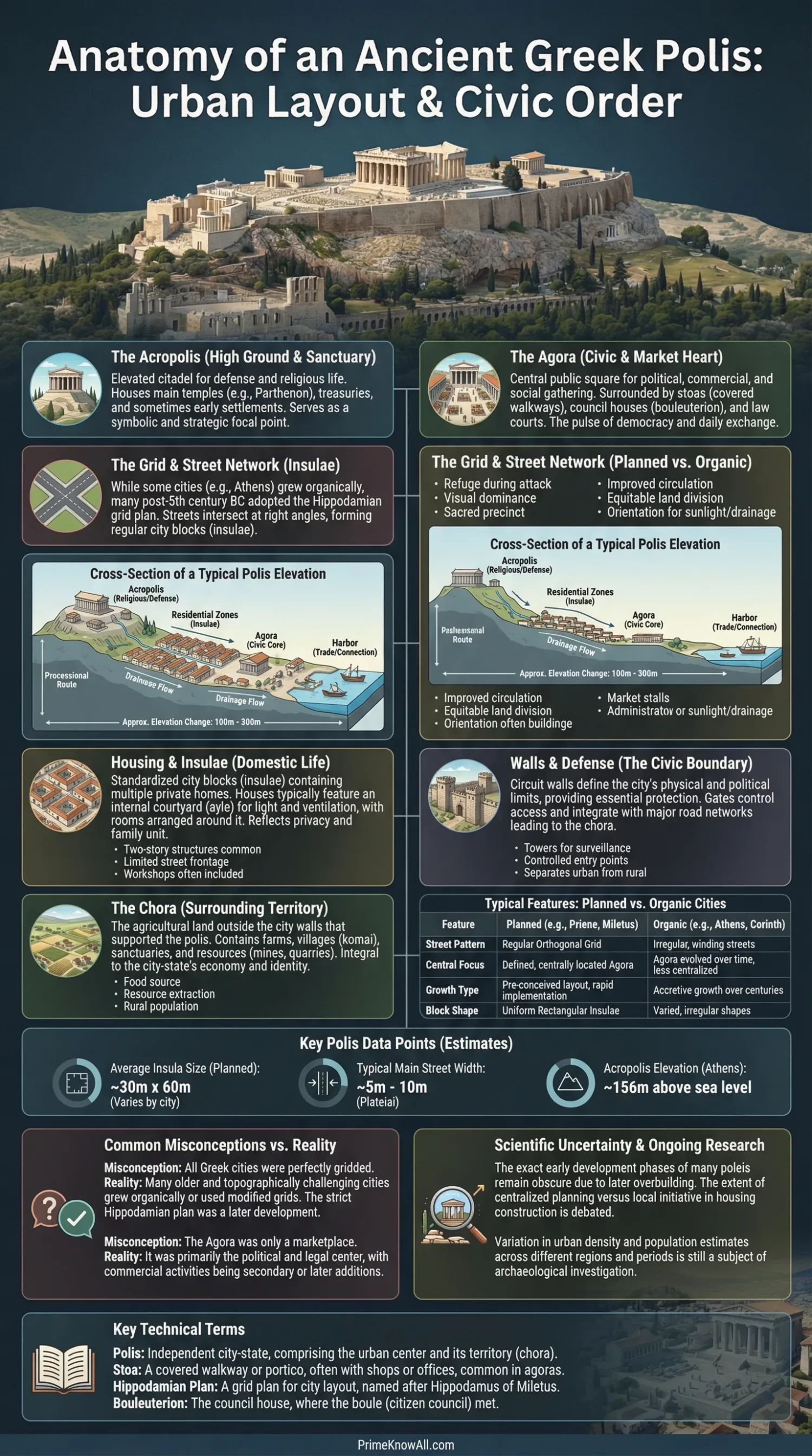
If you remember one thing… the plan of a Greek city-state was a social diagram. A street grid, an agora, a wall, a stoa, or a row of courtyard houses each tells part of the same story: who met whom, where goods moved, how decisions were staged, and what the city wanted to protect.
What To Notice First
- A polis was both urban and rural. The city center mattered, but the land beyond it mattered just as much.
- Not every Greek city used a neat grid. Some grew more organically, especially older settlements and sacred hills.
- The agora was more than a market. In cities such as Athens, it also sat close to law, offices, and public speech.
- Housing was part of civic design. Olynthos shows how domestic plots could be repeated with remarkable regularity.
- Terrain kept shaping the plan. Priene is a clear case: even a disciplined grid had to negotiate a steep slope with terraces and retaining walls.
What a City-State Looked Like in Space
The short answer: a Greek city-state worked through a small set of recurring spaces, but their exact arrangement changed from place to place. The urban core was usually compact, walkable, and easy to read once you know the vocabulary.
- Polis: a sovereign city-state made up of a town and its territory.
- Agora: the shared civic and market square where exchange, meetings, and public visibility overlapped.
- Acropolis: the elevated strongpoint, often used for temples, storage, refuge, or symbolic dominance.
- Stoa: a long colonnaded structure that offered shade, shelter, circulation, and room for trade or civic business.
- Insula: a city unit or urban block; the term is Latin, but archaeologists often use it for Greek sites as well.
- Orthogonal Plan: a layout in which streets meet at or near right angles.
- Chora: the countryside controlled by the polis, including fields, roads, shrines, and farmsteads.
A useful way to picture this is to think of a polis as a layered map, not a single monument. High ground handled prestige and refuge. The square handled visibility and exchange. Streets handled flow. Drains handled survival. Houses handled family life, storage, labor, and small-scale production. That is why urban layout matters so much: it ties daily routine to public order.
Why Layout Was Never Just About Streets
The short answer: street lines only make sense when they are read with terrain, politics, water, and ritual. Urban form followed use, and use was broader than movement alone.
- Defense: walls, gates, slopes, and sightlines shaped expansion.
- Civic Order: council houses, law courts, archives, and stoas needed central, legible positions.
- Religion: sanctuaries often claimed high or visually charged locations.
- Trade: routes, harbors, market access, and storage affected how public space was placed.
- Water: wells, fountains, drains, and slopes had to work with the ground, not against it.
- Social Rhythm: houses opened onto streets differently depending on privacy, status, and local habit.
This is also where a common modern mistake begins. A neat plan can look purely rational to modern eyes, yet Greek city planning was never detached from belief, law, and custom. Geometry helped, but geometry did not rule by itself.
Pause Here:
- A Greek plan is readable only when streets, water, and public institutions are read together.
- A grid can express order, but hills, shrines, and older routes still bend the final result.
- The city and its farmland belong to the same picture.
How Well-Known Sites Organized Space
The short answer: no single city-state speaks for all Greek urbanism. Still, four famous sites show the main patterns very clearly: an older civic center at Athens, a regular residential plan at Olynthos, a highly ordered hillside grid at Priene, and a newly studied Hellenistic plan at Notion.
| Site | General Pattern | Public Core | Housing Clue | Useful Numbers |
|---|---|---|---|---|
| Athens | Partly organic, shaped by long use, sacred topography, and later rebuilding | The Ancient Agora on the northwest slope of the Acropolis, bordered by major civic structures | Housing existed near and around civic zones, but the public center dominates the record | Official Greek culture material describes the agora as the heart of the city on the northwest slope of the Acropolis |
| Olynthos | Strong orthogonal order in the North Hill extension | Public functions kept distinct from repeated residential units | More than 100 houses were excavated; repeated courtyard-house planning is unusually clear | A 2025 aerial-planning study, drawing on earlier excavation data, describes North Hill units about 86 × 36 m with ten houses and a sewer lane; Avenue A about 5 m wide and Avenue B about 7 m |
| Priene | Disciplined grid adapted to a steep hillside | Agora, temples, and public buildings arranged within a terraced urban scheme | Residential plots fit into repeated insulae with visible drainage and street logic | Britannica notes 6 east-west streets, 15 cross streets, about 80 insulae, average insula size about 46 × 34 m |
| Notion | Grid-planned Hellenistic city now being clarified by new excavation | Bouleuterion and houses are refining the civic map | Domestic excavation is being used to test how quickly the city was built and declined | A 2023 excavation report says a new city plan was set in the early or mid-third century BC; the bouleuterion uses a foot module of 0.295 m and sits across a 2.1 m change in level |
These examples also show why “Greek city-state layout” should never be reduced to one frozen diagram. Athens explains civic concentration, Olynthos explains repeated domestic plots, Priene explains planned order on a slope, and Notion shows how new fieldwork can still change the map.
How the Agora, Acropolis, and Streets Worked Together
The short answer: the public square, elevated sanctuary zone, and street network formed the civic spine of many poleis. The relationship varied, but these parts usually worked as a linked system of visibility, access, and hierarchy.
At Athens, official material from the Hellenic Ministry of Culture and the ticketing site for the Ancient Agora places the agora on the northwest slope of the Acropolis and presents it as the heart of the city’s public life. That location matters. It sits low enough for movement and exchange, but close enough to civic and sacred landmarks to keep politics visible in everyday space.
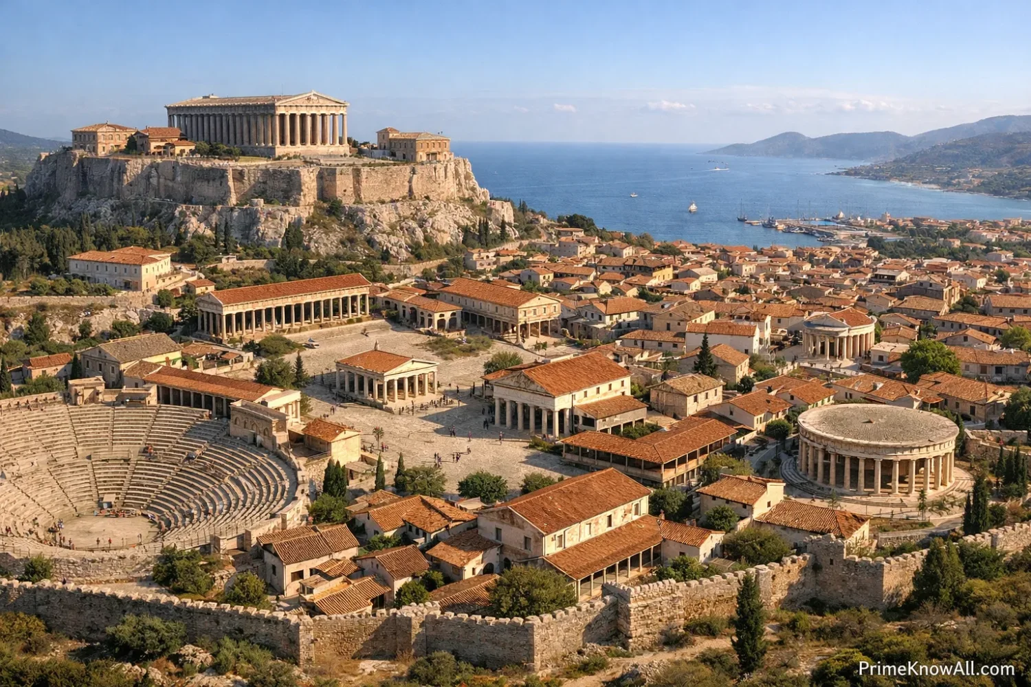
- The Agora Gathered People. Buying, selling, listening, waiting, and petitioning could happen in the same zone.
- The Acropolis Dominated the Skyline. It was hard to ignore, and that was the point.
- Main Routes Stitched the City Together. Processional roads, gate access, and cross-streets turned open space into an urban sequence.
- Stoas Slowed Movement in a Useful Way. They provided edge, shelter, and places to stop without leaving the public arena.
For readers used to modern downtowns, the easiest comparison is this: the agora was not just a market square. It behaved more like a shared civic operating zone, where administration, memory, religious display, and social contact stayed in public view.
How Houses Fit Into the Plan
The short answer: Greek houses were not random fillers between public monuments. In many planned cities, especially Olynthos, houses were part of the logic of the city itself.
The best place to see this is Olynthos, often written as Olynthus in English. The University of Michigan’s Olynthos Project notes that the site gives some of the most detailed evidence for Greek housing anywhere. A well-known study of the site reports more than 100 excavated houses, while later planning research describes repeated urban units in which rows of houses share a consistent spatial grammar.
- Repeated Plots Created Readable Neighborhoods.
- Courtyards Worked as Light Wells, Work Zones, and Social Filters.
- Shops and Workshops Could Sit Within Domestic Units.
- Drains and Small Service Lanes Mattered as Much as Walls and Doorways.
One often-cited figure from Olynthian research is the roughly 17.2 m house plot width noted in Nicholas Cahill’s study, while a 2025 aerial-sensing article summarizing the excavated North Hill describes 86 × 36 m residential units divided into ten houses with a sewer passage between the rows. Even if those numbers vary slightly by area, the wider point is steady: domestic regularity was part of civic order.
What Matters Most Here:
- Private houses were woven into the public logic of the city.
- Olynthos is valuable because the houses survived in repeatable patterns, not as isolated ruins.
- Urban design in a polis can be read from doors, drains, courtyards, and workshops, not only from temples.
Grid Plans and Organic Growth Were Both Greek
The short answer: the famous grid is real, but it is only one side of the story. Greek urbanism includes both planned regularity and messier historical growth.
Hippodamus of Miletus is the name most readers meet first. Britannica describes him as famous for a theory of town planning, but also notes that orthogonal planning was not fully his invention. That correction matters. It keeps the history honest. Greek planners refined and popularized rectilinear urban order, yet older routes, sacred sites, and local terrain were already shaping cities before any textbook “Hippodamian” model was named.
- Athens Shows Layered Growth. Its civic center became dense through long use, rebuilding, and political change.
- Priene Shows Planned Clarity. The grid is disciplined, but terraces prove the hillside still had the final vote.
- Olynthos Shows Repeated Housing Logic. Residential regularity can be stronger than monumentality.
- Notion Shows That Planning Could Be Reset. A new city plan in the early or mid-third century BC points to deliberate urban reordering.
The practical lesson is simple: Greek urban layout was neither chaos nor perfect geometry. It was a negotiation between design, memory, land, and need.
A Text-Based Visual of a Greek Polis
The short answer: if the pieces are stacked vertically, the plan becomes easier to read. This text infographic compresses the usual urban sequence into one visual strip.
Read from top to bottom as a flow of power, movement, and daily life.
Acropolis, citadel, or dominant hill.
Used for temples, storage, lookout points, prestige, and refuge.
Agora, stoas, council house, archives, law spaces, shrines.
This is where public life became visible.
Main routes, secondary lanes, gates, processional paths.
Some cities look organic, others more orthogonal, most are mixed.
Courtyard houses, workshops, shops, storage, wells, drains.
At Olynthos, repeated plots make this layer unusually clear.
Walls, towers, gates, roads to fields, cemeteries beyond the city edge.
The boundary was never just defensive; it also organized movement and identity.
Farms, orchards, quarries, sanctuaries, harbor links, rural roads.
No polis can be understood if the city is cut away from its land.
Common Misreadings
The short answer: many familiar claims about Greek urban layout are too neat. A better reading keeps the evidence broad and the language measured.
- Misreading: Every Greek city-state followed a grid.
Better Reading: Many did not, or only partly did.
Why the Mix-Up Happens: textbook diagrams favor the clearest planned examples. - Misreading: The agora was just a marketplace.
Better Reading: In many cities it was also a civic, legal, and social stage.
Why the Mix-Up Happens: modern readers hear “market” and miss the political uses of open space. - Misreading: Houses were private and therefore archaeologically secondary.
Better Reading: Housing can reveal class, work, water use, and neighborhood design.
Why the Mix-Up Happens: temples and theaters are more visually famous. - Misreading: Hippodamus invented the grid from nothing.
Better Reading: he is tied to planning theory and to famous planned cities, but rectilinear layouts predate him.
Why the Mix-Up Happens: a single named planner makes the story easier to remember. - Misreading: A neat plan means a socially equal city.
Better Reading: repeated plots can still contain status differences, varied house sizes, and mixed economic roles.
Why the Mix-Up Happens: regular geometry can look fairer than lived reality. - Misreading: The city alone is the polis.
Better Reading: the urban center and the chora belong to the same political unit.
Why the Mix-Up Happens: ruins are easier to photograph than fields, roads, and territorial control.
Before Moving On:
- The clearest sites are not always the most typical ones.
- A sacred hill, a wall, or an old road can matter just as much as a street grid.
- Urban layout is easiest to understand when domestic evidence and civic evidence are read together.
Where This Still Feels Familiar
The short answer: Greek urban layout can feel remote until it is connected to ordinary movement. These short scenarios help fix the logic in memory.
- A traveler leaves a gate and heads straight toward the square. Why this makes sense: gates, roads, and public space were often aligned to turn arrival into orientation.
- A shop opens near a house instead of far away from it. Why this makes sense: in cities such as Olynthos, work and domestic life could share one urban unit.
- A steep slope forces planners to terrace the city. Why this makes sense: Priene shows that even tidy plans must obey topography.
- A council house sits where people can reach it without crossing a maze. Why this makes sense: civic access had to be visible and practical, not hidden.
- A wide colonnade fills with people on a hot day. Why this makes sense: stoas were social climate-control devices as much as architectural edges.
- A drain or sewer line runs through a repeated residential zone. Why this makes sense: sanitation and runoff were part of urban order, not an afterthought.
- A city looks different after one rebuilding phase. Why this makes sense: wars, refoundations, and new political priorities could reset the plan.
If that sounds modern, it should. Anyone who uses a map app to judge shade, slope, access, and destination density is asking some of the same questions Greek planners and residents had to solve without digital tools.
What New Research Is Changing
The short answer: this subject is still moving. New excavation, rescue archaeology, aerial imaging, and digital reconstruction are sharpening old city plans and sometimes revising them.
A good example is Notion, on the western coast of today’s Türkiye. A recent excavation report states that a new city plan was set there in the early or mid-third century BC, and current work is testing how quickly the city filled out and how quickly it later thinned. A Princeton event summary on the same project describes Notion as a grid-planned city with stout fortification walls, while the report itself gives precise module data for the bouleuterion, including a local foot of 0.295 m.
Olynthos is another active case. A 2026 study in Heritage presents a parametric, city-scale reconstruction method for the site, using labor estimates and digital modeling to ask who could actually have built these repeated houses and how coordinated that work must have been. That is a fresh angle. It turns the city plan from a static map into a problem of timing, labor, and civic organization.
- Remote Sensing Helps Trace Buried Urban Order.
- Digital Reconstruction Tests Whether a Plan Was Realistic to Build.
- Rescue Excavation Inside Modern Athens Keeps Adding Fine-Grained Topographic Data.
One striking reminder comes from Athens. Cambridge’s 2025 archaeological news review reports rescue excavations during 2024–25 that uncovered a 68 m by 11 m Roman-era complex with 60 rooms around a peristyle courtyard. That is later than the classical polis, but it shows something important: urban ground in Greek cities kept being reused, overwritten, and rediscovered.
What The Evidence Cannot Fully Show
The short answer: the map is never complete. Scholars know far more about some city-states than others, and preservation strongly shapes what can be said with confidence.
Work linked to the Copenhagen Polis Centre reminds us how uneven the record is. More than 1,035 identifiable poleis are known for the Archaic and Classical periods, yet an Oxford study notes that city area can be estimated for only 232 of them with fair certainty. That gap matters. It means famous sites like Athens, Olynthos, and Priene are very informative, but they do not speak for every polis in the Greek world.
- Stone Survives Unevenly. Wood, mudbrick, and light structures are easier to lose.
- Excavation Is Selective. Whole districts can remain unexcavated.
- Later Rebuilding Blurs Earlier Plans. Athens is the obvious example.
- Rural Space Is Harder to Visualize. The chora is essential, yet less legible to casual readers than walls or temples.
So the safest rule is this: treat the best-known plans as strong case studies, not as universal templates.
Evidence Check:
- Greek urbanism is better documented at a handful of sites than across the full range of poleis.
- Numbers are helpful, but they need context.
- Preservation can distort what looks “typical.”
Quick Test
The short answer: these short checks help confirm the main ideas without turning the page into a quiz sheet.
Is a polis just a walled town?
No. A polis includes the town and its chora, the territory that fed and supported it.
Did every Greek city-state use a perfect grid?
No. Orthogonal planning became famous, but many cities show mixed growth, older routes, or terrain-driven irregularity.
Why is Olynthos so useful for urban layout?
Because it preserves repeated courtyard-house planning and unusually clear neighborhood patterning, with more than 100 excavated houses reported in the scholarship.
Why is Priene so often shown in textbooks?
Because its hillside grid is unusually legible. The city combines right-angled planning with terraces, drainage, and well-defined insulae.
Was the agora only about shopping?
No. In many poleis, especially well-documented cases such as Athens, the agora also served civic, legal, social, and ceremonial purposes.
What To Hold On To
Ancient Greek city-states arranged space to make public life workable. Their plans linked high ground, public squares, streets, houses, drains, and territory into one visible civic order.
The most common mistake is to treat the grid as the whole story.
A good rule to keep: when reading a Greek city plan, follow terrain, water, and public access before chasing geometry alone.
Sources
- Hellenic Ministry of Culture – Ancient Agora of Athens — Useful for the official location and site description of the agora. Why reliable: it is the Greek state’s own cultural heritage portal for the monument.
- Official Ancient Agora Visitor PDF – Ancient Agora — Supports the description of the agora as the heart of the city and a center of public activity. Why reliable: it comes from the official ticketing and site-information system for Greek monuments.
- UNESCO – Archaeological Site of Priene — Helps explain Priene as a compact, highly legible late Classical and Hellenistic city and notes its terraced character. Why reliable: UNESCO site dossiers are curated heritage records tied to formal nomination material.
- Britannica – Priene — Supports the street count, insula count, and average insula dimensions used in the Priene discussion. Why reliable: Britannica is a long-running reference work with editorial review and stable topic pages.
- Britannica – Hippodamus of Miletus — Useful for the correction that orthogonal planning was linked to Hippodamus without being wholly his invention. Why reliable: it is a vetted reference entry focused on the named planner.
- University of Michigan – Olynthos Project: Houses — Supports the claim that Olynthos offers unusually detailed evidence for Greek housing. Why reliable: it is a university field project page built around ongoing archaeological research.
- Heritage (2025) – Aerial Remote Sensing and Urban Planning Study of Ancient Hippodamian System — Used for the Olynthos block, avenue, and planning figures summarized from excavation data and aerial analysis. Why reliable: it is a peer-reviewed article with method, data, and bibliography available for checking.
- Heritage (2026) – Mapping and Estimating Labor and Production with OiKoS — Supports the note that new digital modeling is changing how Olynthos is interpreted. Why reliable: it is a recent peer-reviewed study focused on method and measurable reconstruction.
- University of Michigan / Turkish Ministry Project Report – Archaeological Research at Notion, 2022–2023 — Used for the new city plan date, the bouleuterion module of 0.295 m, and the 2.1 m level change. Why reliable: it is a formal excavation report from the active research team.
- Princeton University – Archaeological Research at the Ancient Ionian City of Notion — Useful for the concise description of Notion as a grid-planned city with fortification walls. Why reliable: it is a university event page summarizing a research lecture by the excavation director.
- Oxford Academic – Polis: The Size and Population of the Cities — Supports the caution that only 232 of 1,035 poleis can be measured for city area with fair certainty. Why reliable: Oxford Academic hosts scholarly books and chapters with clear editorial control.
- Google Books Preview – An Inventory of Archaic and Classical Poleis — Used for the count of 1,035 identifiable Greek city-states in the Archaic and Classical periods. Why reliable: it points to a major scholarly reference work produced by the Copenhagen Polis Centre.
- Cambridge Core – Archaeological Reports Newsround — Supports the note on 2024–25 rescue excavation in Athens and the 68 m × 11 m complex with 60 rooms. Why reliable: it is part of a long-standing academic reporting series hosted by Cambridge University Press.
FAQ
What was the main purpose of urban layout in an ancient Greek city-state?
Urban layout organized public life. It shaped movement, defense, ritual space, water management, trade, and access to civic institutions.
What is the difference between a polis and a city?
A polis was a sovereign city-state, not just a settlement. It included the urban center and the surrounding territory controlled by that community.
Why is the agora so important in Greek urban planning?
The agora concentrated visibility. It could host exchange, political contact, public notices, religious presence, and routine social life in one shared zone.
Did Hippodamus invent the Greek grid plan?
No, not by himself. He is tied to planning theory and to famous rectilinear plans, but orthogonal layouts existed before him.
Why do historians use Olynthos so often when discussing Greek housing?
Because Olynthos preserves an unusually clear residential pattern, with many excavated courtyard houses that allow house plots, streets, drains, and neighborhood design to be studied together.
Why is Priene often used as a model planned city?
Because its street grid, terraced slope, public zones, and repeated insulae are easier to read than at many other sites. It is one of the clearest preserved examples of a planned Greek city.
What do scholars still not know about Greek city-state layout?
They still debate how typical the best-known sites really are, how quickly some cities were built, and how social differences were distributed across repeated plots. Preservation and excavation gaps leave part of the picture open.