Earth’s surface looks solid, but it is built from moving pieces called tectonic plates. These slabs of the lithosphere (crust plus the uppermost mantle) slide over a softer layer beneath, reshaping continents, building mountains, opening oceans, and triggering earthquakes. Plate tectonics is the unifying theory that explains why Earth has active volcanoes, why some coastlines match like puzzle pieces, and why today’s landscapes are snapshots of a planet that never fully stops moving.
At the core of the idea is simple: the crust is not one shell. It is a mosaic of plates that interact along long, narrow zones called plate boundaries. Where plates meet, rock breaks, melts, rises, or sinks. Over time, that boundary activity becomes visible in ocean ridges, deep trenches, folded ranges, and chains of volcanoes.
What A Tectonic Plate Is
A tectonic plate is a broad, rigid slab of Earth’s lithosphere. Think of it as a thick “skin” made of cold, strong rock. Plates can be oceanic (denser basaltic crust) or continental (lighter granitic crust), and many plates carry both. Underneath is the asthenosphere, a hotter zone of the upper mantle that can flow slowly over geologic time. That contrast—rigid plates above, weaker mantle below—makes large-scale motion possible.
Plates are not thin like ice on water. The lithosphere is typically tens to more than 100 kilometers thick, varying with age and temperature. Young oceanic lithosphere near mid-ocean ridges is thinner and warmer; older oceanic lithosphere becomes thicker and denser as it cools. That cooling history matters because it helps drive subduction, where a plate bends and sinks back into the mantle.
How Many Plates Are There
Earth has about 7–8 major plates and many smaller ones. The boundaries between them create most of the planet’s geologic action. Even a “small” plate can control major hazards if it sits in a busy boundary zone, so size is not the whole story.
- Major plates often include the Pacific, North American, South American, African, Eurasian, Antarctic, and Indo-Australian (sometimes split into Indian and Australian).
- Notable smaller plates include the Nazca, Philippine Sea, Arabian, Caribbean, Cocos, Scotia, and Juan de Fuca.
Why Earth’s Crust Moves
Plate motion is powered by Earth’s internal heat. Some of that heat is left over from planetary formation, and some comes from radioactive decay inside the mantle and crust. Heat tries to escape, and the mantle responds by circulating slowly. This circulation is not like boiling water with fast bubbles; it is more like warm wax creeping over long timescales. Plates move because they are coupled to this flowing mantle and because gravity pulls on cold, dense parts of the lithosphere.
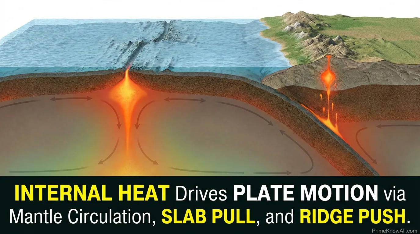
The Three Big Drivers Of Plate Motion
Scientists debate the exact balance between forces, but most explanations focus on a set of complementary drivers. Together they explain how plates can move a few centimeters per year—about the speed fingernails grow—yet still rearrange whole oceans across millions of years.
- Slab pull: At subduction zones, old oceanic lithosphere becomes dense and sinks. The sinking slab exerts a pulling force on the rest of the plate, like a heavy curtain sliding off a table.
- Ridge push: Mid-ocean ridges are elevated because newly formed lithosphere is hot and buoyant. As it cools, it slides “downhill” away from the ridge, adding a pushing component.
- Mantle drag: Flow in the mantle can help steer plates. In some regions, convection may assist motion; in others, the mantle can also resist it, acting as friction.
Plate tectonics is not a single “motor.” It is a system where heat, gravity, and rock strength interact, producing steady motion punctuated by sudden slips that become earthquakes.
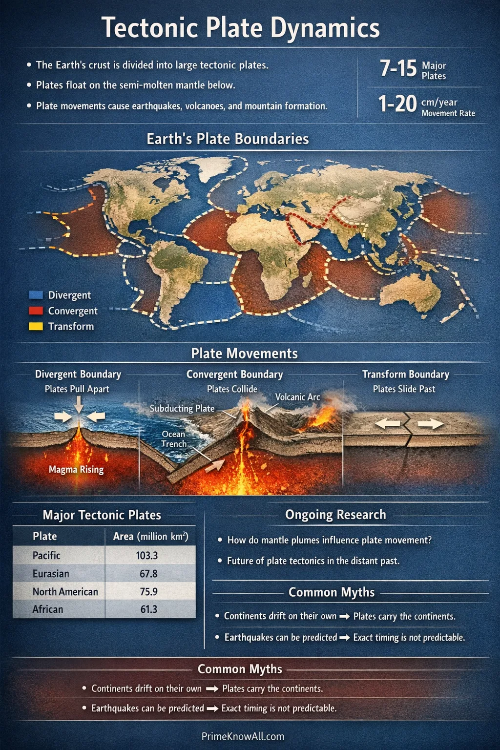
Where Plates Meet: Boundary Types And What They Make
Most dramatic geology happens at plate boundaries. Boundaries are not always clean lines; they can be wide belts of faults and deformed rock. Still, they fall into a few main categories that describe how plates move relative to each other. Each type has a recognizable signature in topography, seismicity, and volcanism.
| Boundary Type | Plate Motion | Typical Features | Common Hazards | Well-Known Examples |
|---|---|---|---|---|
| Divergent | Plates move apart | Mid-ocean ridges, rift valleys, new crust formation | Shallow earthquakes, volcanic eruptions (often effusive) | Mid-Atlantic Ridge, East African Rift |
| Convergent (Subduction) | Plates move together; one sinks | Ocean trenches, volcanic arcs, accretionary wedges | Large earthquakes, tsunamis, explosive volcanism | Andes, Japan Trench, Aleutian Arc |
| Convergent (Collision) | Continents collide | High mountains, thickened crust, broad uplift | Major earthquakes, landslides (little volcanism) | Himalayas, Alps |
| Transform | Plates slide sideways | Linear faults, offset landforms, pull-apart basins | Shallow, damaging earthquakes | San Andreas Fault, North Anatolian Fault |
Divergent Boundaries: Building New Ocean Floor
At divergent boundaries, plates separate and the mantle rises to fill the gap. As pressure drops, mantle rock can partially melt, producing magma. That magma cools to become new oceanic crust. Over millions of years, this process forms vast mid-ocean ridges—the longest mountain range on Earth, mostly hidden under water.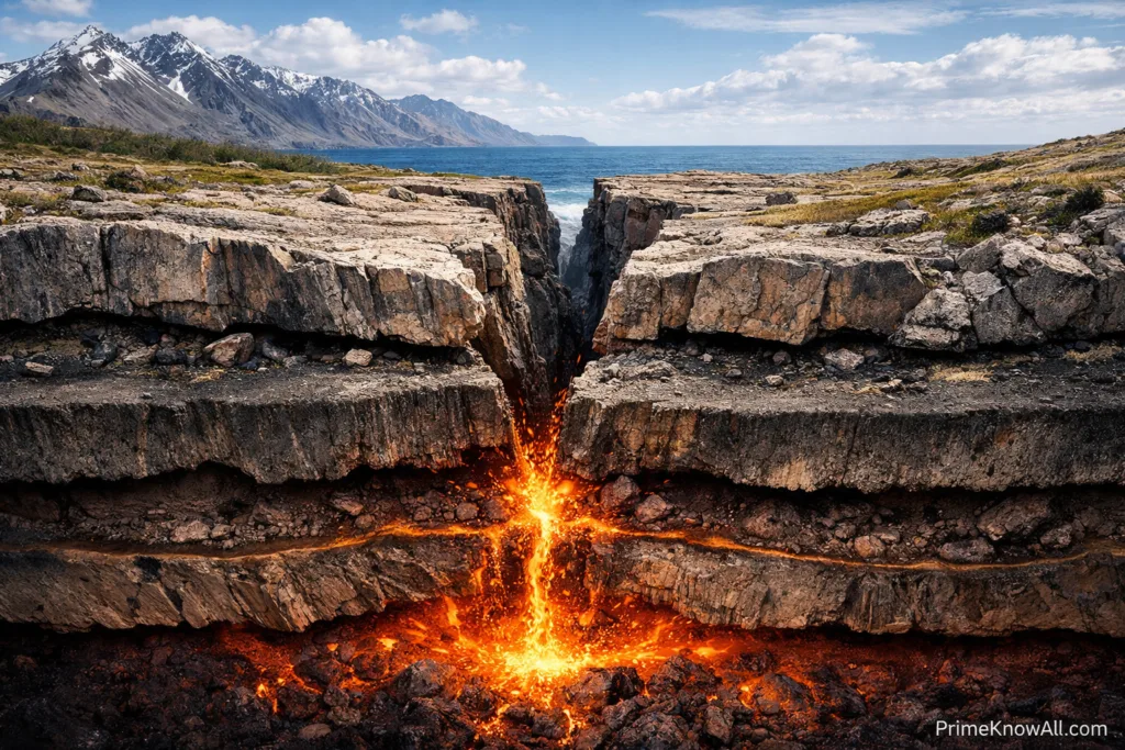
Divergence can also happen within continents, creating rift valleys. If rifting continues, the crust thins until a new ocean basin forms. The early stages are marked by fault-bounded basins, volcanoes, and earthquakes that tend to be shallow but can still be destructive.
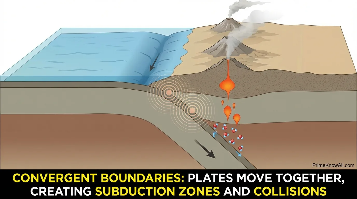
Convergent Boundaries: Subduction Zones And Collisions
At convergent boundaries, plates move together. If an oceanic plate meets another plate, the denser oceanic lithosphere usually bends and sinks into the mantle. This is subduction. Subduction zones recycle crust, drive powerful earthquakes, and feed volcanic arcs. Water carried down with the slab lowers the melting point of mantle rock above it, helping generate magma. That is why many explosive volcanoes ring the Pacific in the “Ring of Fire.”
When two continents converge, neither one wants to sink because continental crust is relatively buoyant. Instead, the crust shortens and thickens, pushing rock upward into high mountain belts. These collision zones can be geologically complex, with deep roots, stacked thrust faults, and broad uplift that reshapes regional climate by altering wind and rainfall patterns.
Transform Boundaries: Sideways Motion, Sudden Quakes
Transform boundaries accommodate sideways motion. Plates grind past each other, and the friction can lock faults for long periods. When the fault finally slips, stored elastic energy is released as an earthquake. Transform faults can connect segments of mid-ocean ridges, but on land they can cut through populated regions, making them central to seismic risk.
A Useful Way To Picture Boundaries
Imagine a cracked sidewalk made of large slabs. If slabs separate, gaps open and material can rise in between. If slabs collide, edges crumple and stack. If slabs slide past, the cracks become grinding faults. Earth’s plates behave similarly, but with hot rock flow and gravity adding extra power.
How Fast Plates Move And How Motion Is Measured
Plate motion is slow on a human timescale, yet it is measurable. Many plates move at rates of roughly 1–10 centimeters per year. Over a century, that can be meters. Over a million years, it can be tens of kilometers. The key is that the movement is persistent, so small annual changes accumulate into vast rearrangements.
Modern Tools: GPS And Satellite Geodesy
Today, networks of GPS stations track the slow drift of Earth’s surface with impressive precision. By comparing positions over time, scientists map plate velocities, detect how strain builds near faults, and measure how the crust rebounds after big earthquakes. Radar satellites can also image subtle ground deformation over wide areas, adding a map-like view of motion that would be invisible from ground observations alone.
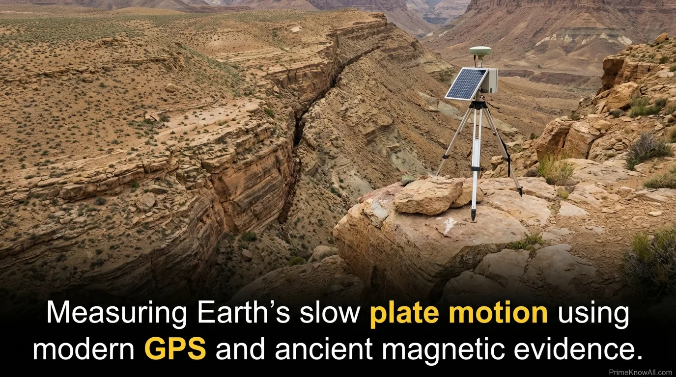
Older Evidence: Magnetic Stripes And Seafloor Spreading
Long before satellites, scientists used geologic fingerprints. One of the strongest is the pattern of magnetic stripes on the ocean floor. As lava cools at mid-ocean ridges, minerals record Earth’s magnetic field direction at that time. Because the magnetic field has reversed many times, the seafloor preserves a symmetrical barcode of normal and reversed polarity on either side of the ridge. That symmetry is powerful evidence for seafloor spreading and provides timelines for ocean crust creation.
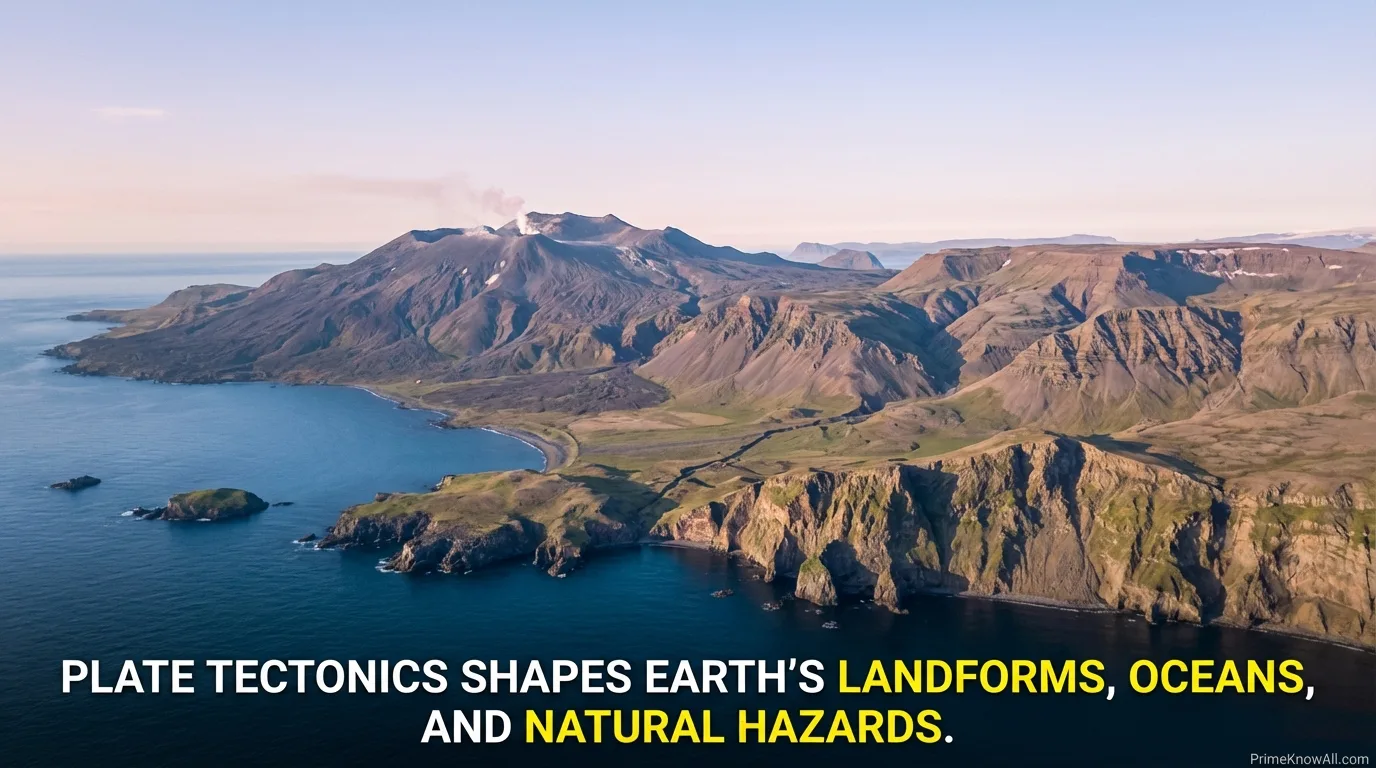
What Plates Build: Landforms, Oceans, And Hazards
Plate tectonics explains Earth’s most recognizable features because it controls where rock is created, where it is destroyed, and where it is squeezed or sheared. The same processes that sculpt scenery also concentrate many natural hazards, which is why understanding plate settings matters for planning and resilience.
Mountains And Plateaus
Large mountain belts commonly form where plates converge. In collisions, crust shortens and thickens, creating high elevations and deep crustal roots. In subduction zones, mountains can form from volcanic arcs plus compression and uplift along the continental margin. Over time, erosion carves peaks and valleys, but continued convergence can keep the landscape rising.
Earthquakes And Fault Systems
Earthquakes occur when rock breaks or slips along faults, releasing built-up strain. Plate boundaries are prime locations because they are zones of persistent relative motion. Subduction zones can generate the largest earthquakes on Earth and can also produce tsunamis when seafloor displacement moves huge volumes of water. Transform faults often generate shallow quakes that can be especially damaging near cities because shaking is close to the surface and can be intense.
Volcanoes And The Chemistry Of Melting
Volcanoes cluster in specific tectonic environments. At divergent boundaries, decompression melting produces basaltic magma that often erupts in relatively fluid flows. At subduction zones, water and other volatiles help generate magmas that can be more viscous and gas-rich, increasing the likelihood of explosive eruptions. Not all volcanoes sit on boundaries, though; some form above hot spots, where persistent mantle upwelling creates chains of volcanoes as a plate moves overhead.
Oceans Open, Oceans Close
Mid-ocean ridges create new seafloor, while subduction zones destroy it. This balance means ocean basins are not permanent features. Over geologic time, oceans can widen as ridges dominate or shrink as subduction “consumes” oceanic lithosphere. Continents drift, collide, and split, forming supercontinents and then breaking apart again. This long cycle reshapes coastlines, reorganizes currents, and changes marine geography.
Inside The Plate: Why Some Earthquakes Happen Away From Boundaries
It is tempting to think earthquakes and volcanoes only happen at boundaries, but Earth is more complicated. Plates contain old faults, rifts, and weak zones that can reactivate under modern stress. Some intraplate earthquakes occur because far-field forces from plate boundaries are transmitted across the plate and concentrate in a weaker region. Intraplate volcanic activity can also occur above hot spots or in areas where the lithosphere is unusually thin. These cases are reminders that plates are rigid overall, but not perfectly uniform.
- Intraplate earthquakes often involve ancient structures that become weak points under modern stress.
- Hot spot chains can record plate motion as a line of volcanoes with ages that change along the chain.
- Rift zones inside continents may mark the early stages of future plate boundaries.
Common Misunderstandings About Plate Tectonics
Plate tectonics is widely taught, yet a few misconceptions keep showing up. Clearing them up helps the core idea feel cleaner and more intuitive.
- “Plates float on magma.” Plates do not ride on a global ocean of liquid rock. The mantle is mostly solid but can flow slowly because it is hot and under pressure. Melt exists in pockets and channels, especially near ridges and arcs.
- “Continents move, oceans stay.” Continents are parts of plates, and oceanic crust is also part of plates. Whole plates move, carrying both.
- “Boundaries are thin lines.” Some are narrow, but many are wide zones with multiple faults and complex deformation.
- “Plates always move smoothly.” Average motion can be steady, but faults can lock and then slip suddenly, creating earthquakes that release strain in seconds.
Why Plate Tectonics Matters Beyond Geology
Plate tectonics does more than explain rocks. It helps shape the long-term environment that life depends on. The movement of plates influences mountain building and erosion, which affect nutrients delivered to oceans. Subduction and volcanism are part of Earth’s deep carbon cycle, moving carbon between the surface and the interior over long timescales. The arrangement of continents also changes ocean gateways and currents, which can influence climate patterns across geologic eras.
Even the distribution of resources connects to tectonics. Many ore deposits form in environments associated with arcs, rifts, and ancient collision zones. Understanding tectonic history can guide where geologists look for certain materials, while modern plate models support better assessments of earthquake and volcano risk in rapidly growing regions.
Sources
U.S. Geological Survey (USGS) – This Dynamic Earth: The Story Of Plate Tectonics (Clear overview of plate boundaries, plate motions, and the evidence behind the theory.)
U.S. Geological Survey (USGS) – Plate Tectonics (Focused explanations of plate interactions, earthquakes, and boundary types.)
NASA Earth Observatory – Plate Tectonics (Readable background on why plates move and how tectonics shapes Earth’s surface.)
Lamont-Doherty Earth Observatory (Columbia University) – Plate Tectonics Research Topics (University research context on plate motion, mantle processes, and related observations.)
NOAA NCEI – Tsunami Data And Information (Helpful for understanding how subduction-zone earthquakes can generate tsunamis and how they are studied.)
FAQ
Do tectonic plates ever stop moving?
Plates can slow down or change direction, but as long as Earth continues losing internal heat and the mantle can flow, the system tends to keep plates in motion. Over very long timescales, the pattern of boundaries can reorganize, which changes how and where motion happens.
How can plates move if the mantle is solid?
The mantle is mostly solid rock, but at high temperature and pressure it can deform slowly, like a very stiff material that creeps over time. That slow flow, combined with gravity-driven forces like slab pull, allows rigid plates to move across the weaker upper mantle.
What causes the biggest earthquakes?
The largest earthquakes usually occur at subduction zones, where one plate dives beneath another and the boundary can lock over a very large area. When it slips, the release of strain can be immense and may also trigger tsunamis if the seafloor is displaced.
Why are there volcanoes far from plate boundaries?
Some volcanoes form above hot spots, where mantle material rises and partially melts beneath a plate. As the plate moves, it can create a chain of volcanoes. Other intraplate volcanoes can appear where the lithosphere is thin or stressed, allowing magma to reach the surface more easily.
How do scientists measure plate motion today?
Scientists use GPS networks to track ground positions over time and calculate precise velocities, often at the millimeter scale. Satellite radar methods can also map subtle surface deformation across wide areas, helping identify where strain is accumulating near active faults.
Article Revision History
