Earth has one connected global ocean, but for navigation, science, and everyday language it’s often described as five major ocean basins: the Pacific, Atlantic, Indian, Southern, and Arctic. Each one has its own shape, depth profile, and signature role in climate and ecosystems—yet all are linked by currents that move heat, salt, nutrients, and carbon around the planet.
If the goal is to understand ocean names, how deep they get, and the facts that actually matter, it helps to separate three ideas: surface size (area), typical depth (average), and extremes (deepest trenches). Depth numbers are often given as approximations because the seafloor is rugged, surveys vary, and tides and sound-speed corrections affect measurements.
What Counts As An Ocean
An ocean is a vast, continuous body of salty water with basin-scale circulation and a deep seafloor. Seas are usually smaller, often partly enclosed by land, and can behave differently due to restricted exchange with the open ocean. In practice, the line between “sea” and “ocean” is not always crisp, which is why boundaries can look slightly different across maps and datasets.
Most modern references use a five-ocean model. The Southern Ocean is the newest addition in common usage, describing waters that encircle Antarctica and connect the Atlantic, Indian, and Pacific in a powerful current belt. Boundary definitions are often based on latitude, coastlines, and hydrographic convention rather than a physical “wall” in the water.
A Helpful Note On Depth Numbers
When you see a “deepest point,” treat it as best current estimate rather than a permanent constant. Different surveys can produce slightly different results, and some sources report rounded or historic values. The big picture stays the same: the Pacific holds the planet’s deepest trench, while the Arctic is the shallowest basin on average.
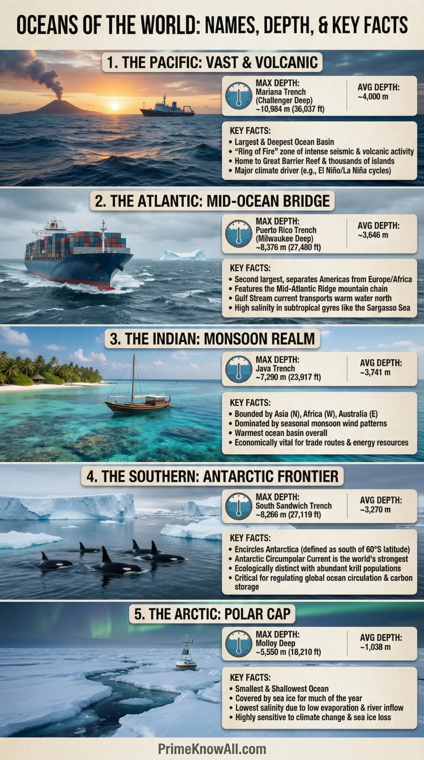
The Five Oceans And Where Their Names Come From
The names are mostly geographic and historical. Pacific was popularized from a term meaning “peaceful,” tied to early European voyages. Atlantic is associated with the Atlas tradition of the ancient world. Indian reflects the ocean’s long connection to the Indian subcontinent and trade routes. Southern is a straightforward regional name for Antarctic waters. Arctic traces to Greek roots connected to the bear constellations in the northern sky.
A Simple Snapshot Of Size And Depth
Area and depth are the two quickest ways to sense how different the oceans really are. The Pacific dominates in both scale and maximum depth, while the Southern stands out for its global ring-like flow. The Arctic is the smallest and tends to be much shallower on average due to broad continental shelves.
| Ocean | Approx. Area (million km²) | Average Depth (m) | Deepest Point (m) | Deepest Feature |
|---|---|---|---|---|
| Pacific | 161.76 | 4,280 | ~10,935 | Challenger Deep (Mariana Trench) |
| Atlantic | 85.13 | 3,646 | 8,380 | Milwaukee Depth (Puerto Rico Trench) |
| Indian | 70.56 | 3,741 | 7,450 | Sunda Deep (Java Trench) |
| Southern | 21.96 | 3,270 | 7,432 | South Sandwich Trench (deepest sector) |
| Arctic | 14.09 | 987 | ~5,500 | Molloy Deep (Fram Strait region) |
Reading Tip: “Average depth” is a typical value for the whole basin, not a prediction of what you’d find at any single spot. The deepest points are usually in trenches, which are narrow features compared to the oceans’ vast abyssal plains.
Pacific Ocean
The Pacific Ocean is the planet’s largest and, in overall terms, its deepest basin. It stretches from the Arctic in the north to the waters around Antarctica in the south, bordered by Asia and Australia on one side and the Americas on the other. That scale makes the Pacific a major stage for weather patterns, from tropical rainfall belts to powerful mid-latitude storms.
Its seafloor includes some of Earth’s most dramatic tectonic architecture. The Pacific hosts the Mariana Trench and the Challenger Deep, around 10,935 meters below sea level in commonly cited modern estimates. Even away from trenches, the Pacific contains huge regions of abyssal plains and long chains of volcanic seamounts—evidence of plates moving over hotspots and spreading ridges.
- Depth Personality: More frequent very deep trenches along active plate boundaries.
- Circulation: Dominated by large gyres (notably in the North and South Pacific) that steer heat and nutrients.
- Seafloor Clues: The Pacific “Ring of Fire” reflects intense subduction and volcanic arcs along its margins.
Why The Pacific Holds The Deepest Point
Extreme depth is most likely where an oceanic plate bends and dives beneath another plate. That process creates narrow, steep-sided trenches that can reach hadal depths (below 6,000 meters). The Pacific has more of these active margins than any other basin, so it naturally contains the largest collection of very deep trenches.
Atlantic Ocean
The Atlantic Ocean is narrower than the Pacific but still immense, forming a long corridor between the Americas and Europe/Africa. Its shape makes it especially important for heat transport between hemispheres, with currents and winds organizing into large-scale circulation that influences coastal climates.
A defining feature is the Mid-Atlantic Ridge, an underwater mountain chain where new seafloor forms. While the Atlantic has deep trenches, it is often characterized more by this central ridge system and broad basins than by a ring of major subduction zones. The Atlantic’s maximum depth is commonly cited around 8,380 meters in the Puerto Rico Trench, near the deepest known point called the Milwaukee Depth.
- Depth Personality: Deep basins plus a central ridge that shapes seafloor topography.
- Signature Current: The Gulf Stream system moves warm water northward, affecting weather and sea level along coasts.
- Geologic Story: A classic example of seafloor spreading linked to the breakup of ancient supercontinents.
Atlantic Depth In Plain Terms
The Atlantic can feel “less extreme” than the Pacific because its deepest regions are more localized. The average depth is still thousands of meters, but the basin’s overall profile is shaped by the ridge and wide abyssal plains rather than frequent trench arcs. That difference shows how plate tectonics can influence an ocean’s whole character.
Indian Ocean
The Indian Ocean is often described as the warmest major ocean basin overall, largely because much of it sits in tropical and subtropical latitudes. It is bounded by Africa to the west, Asia to the north, Australia and island chains to the east, and the Southern Ocean to the south. That geography gives it a distinctive mix of enclosed seas and open-water expanses.
Depth-wise, the Indian has a large area of deep ocean, but its most famous extreme is the Java Trench, where the deepest point is often listed around 7,450 meters in the Sunda Deep. Like other trenches, this is tied to active plate boundaries. But the Indian also contains vast submarine plateaus and ridges that create a seafloor with big, readable structures.
- Depth Personality: A mix of deep basins and prominent ridges/plateaus.
- Seasonal Rhythm: Wind patterns can reverse across parts of the basin, creating strong seasonal shifts in surface circulation.
- Human Geography: Long-standing routes for trade, navigation, and cultural exchange across coasts and island chains.
Southern Ocean
The Southern Ocean surrounds Antarctica and is unique because it forms an almost continuous belt of water with no continental landmass blocking its path. This layout supports the Antarctic Circumpolar Current, a powerful flow that connects the Atlantic, Indian, and Pacific and helps organize the planet’s deep ocean circulation.
Although it is smaller in area than the three “major” oceans (Pacific, Atlantic, Indian), it is far from shallow. A commonly cited average depth is around 3,270 meters, and the maximum depth is about 7,432 meters in the South Sandwich Trench. Its harsh winds, cold waters, and seasonal sea ice make it a key region for studying ocean mixing and deep-water formation.
- Depth Personality: Deep basins with notable trench systems on the Atlantic-sector side.
- Climate Link: Major influence on global heat and carbon exchange through strong winds and upwelling.
- Standout Feature: The only ocean that fully encircles the planet without being interrupted by continents.
If one ocean deserves the title “connector,” it is the Southern Ocean. Its currents and winds help stitch the global ocean into a single, planet-spanning system.
Arctic Ocean
The Arctic Ocean is the smallest of the five and is centered near the North Pole, surrounded by North America, Eurasia, and Greenland. A large fraction of its area lies over broad continental shelves, which is why it tends to have a lower average depth than the other oceans.
Average depth values vary by definition and dataset, but many standard references place it around about one kilometer (roughly 1,000–1,200 meters). Its deepest known area is commonly associated with the Molloy Deep region, around 5,500 meters. Sea ice and strong seasonal shifts in light make the Arctic a distinctive environment where surface conditions can change rapidly while deep waters remain relatively stable.
- Depth Personality: The most shelf-dominated ocean, generally shallower than the others.
- Ecosystem Note: Life is tightly linked to ice dynamics, seasonal blooms, and nutrient timing.
- Practical Reality: Mapping and observations are challenging, so some details keep improving as surveys expand.
How Ocean Depth Is Measured
Modern depth measurements rely heavily on echo sounding (sonar). A ship sends a sound pulse downward, and the return time is converted into depth using the speed of sound in seawater, which depends on temperature, salinity, and pressure. Multibeam sonar can map swaths of the seafloor in high detail, turning a single line of depth readings into a 3D terrain model.
Satellites also contribute, but in a different way. Space-based measurements of sea-surface height reveal subtle gravitational “bumps” caused by undersea mountains and trenches. This creates a useful global sketch, but it cannot match the detail of ship-based sonar. That’s why a major push in ocean science is high-resolution seafloor mapping, and why the global map is still incomplete.
Mapping Reality Check
As of June 2025, a little over one quarter of the global seafloor had been mapped with modern high-resolution methods. That means many “depth facts” are still improving as better data arrives, especially in remote or ice-affected regions.
Depth Zones People Often Mix Up
When articles talk about “deep ocean,” they often mean very different things. Oceanographers commonly describe depth by zones that reflect changes in light, pressure, and ecology. Knowing the zones makes depth numbers feel more real.
- Sunlit Layer (Epipelagic): 0–200 meters, where most photosynthesis occurs.
- Twilight Layer (Mesopelagic): 200–1,000 meters, dim light and daily vertical migrations.
- Midnight Waters (Bathypelagic): 1,000–4,000 meters, no sunlight, high pressure.
- Abyssal Depths (Abyssopelagic): 4,000–6,000 meters, cold, stable, and vast.
- Hadal Zone: below 6,000 meters, mostly trenches like Challenger Deep.
Why Oceans Differ So Much In Depth
The biggest driver is plate tectonics. Oceans bordered by active subduction zones tend to develop more extreme trenches. Oceans dominated by spreading ridges and passive margins tend to have broader abyssal plains and fewer ultra-deep points. Over millions of years, sediment can also “soften” the seafloor’s profile by filling basins, while volcanic hotspots build seamount chains that rise thousands of meters from the deep.
Glaciation and shelf structure also matter. The Arctic is surrounded by large continental margins, so shelf seas occupy a bigger fraction of its area. The Southern Ocean, by contrast, wraps around a continent and interacts strongly with winds, ice, and deep-water formation—features that shape its circulation identity as much as its depth numbers.
Practical Ways To Use Ocean Facts
Ocean facts are not just trivia. Knowing which basin you’re talking about clarifies everything from storm tracks to shipping distances to where scientists look for specific seafloor features. Depth awareness also helps explain why some regions have rich fisheries (nutrient upwelling) while others are biological deserts, and why deep ocean exploration is so technically demanding.
- For learners: Connect trenches, ridges, and plate boundaries to real geography.
- For travelers and coastal residents: Understand how nearby currents can shape water temperature and weather.
- For science and tech: Recognize why mapping is the first step before studying habitats, hazards, or resources.
Sources
NOAA National Ocean Service – How Deep Is the Ocean? [Global average depth and Challenger Deep depth context]
NOAA Ocean Exploration – How Much Of The Ocean Has Been Explored? [Up-to-date mapping status and why high-resolution bathymetry matters]
NOAA Ocean Exploration – How Big Is The Pacific Ocean? [Pacific size and depth overview in plain language]
Encyclopaedia Britannica – Pacific Ocean [Area and mean depth reference for the Pacific basin]
Encyclopaedia Britannica – Atlantic Ocean [Area, average depth, and maximum depth reference for the Atlantic]
Encyclopaedia Britannica – Indian Ocean [Area, average depth, and deepest-point reference for the Indian Ocean]
Encyclopaedia Britannica – Southern Ocean [Area and depth references for the Southern Ocean basin]
Encyclopaedia Britannica – Arctic Ocean [Area and depth references for the Arctic Ocean]
International Hydrographic Organization – S-23 Draft (Limits Of Oceans And Seas) [Background on how ocean boundaries and names are standardized]
The Nippon Foundation–GEBCO Seabed 2030 – Project Overview [Global initiative to map the entire seafloor at higher resolution]
FAQ
How many oceans are there: four, five, or one?
There is one connected global ocean, but it is commonly divided into five named basins for clarity: Pacific, Atlantic, Indian, Southern, and Arctic. Some older references use a four-ocean model that does not separate the Southern Ocean.
Which ocean is the deepest?
The Pacific Ocean is considered the deepest because it contains Challenger Deep in the Mariana Trench, with a depth commonly cited around 10,935 meters in modern summaries.
Why do different sources give different “deepest point” numbers?
Depth is measured with sonar and depends on survey coverage, sound-speed corrections, tides, and how the seafloor feature is defined. As mapping improves, values can shift slightly, especially in remote trenches. The ocean’s rank order stays consistent even when exact numbers change.
Is the Southern Ocean officially recognized?
The term Southern Ocean is widely used in science, education, and mapping to describe waters around Antarctica, especially those tied to the Antarctic Circumpolar Current. Formal boundary definitions can vary by standard and edition, so maps may show slightly different limits.
How much of the seafloor is mapped in high detail?
Only a portion of the global seafloor has been mapped with modern high-resolution methods. As of June 2025, a little over one quarter of the seafloor had been mapped to those standards, and the number continues to rise as new surveys are added.
