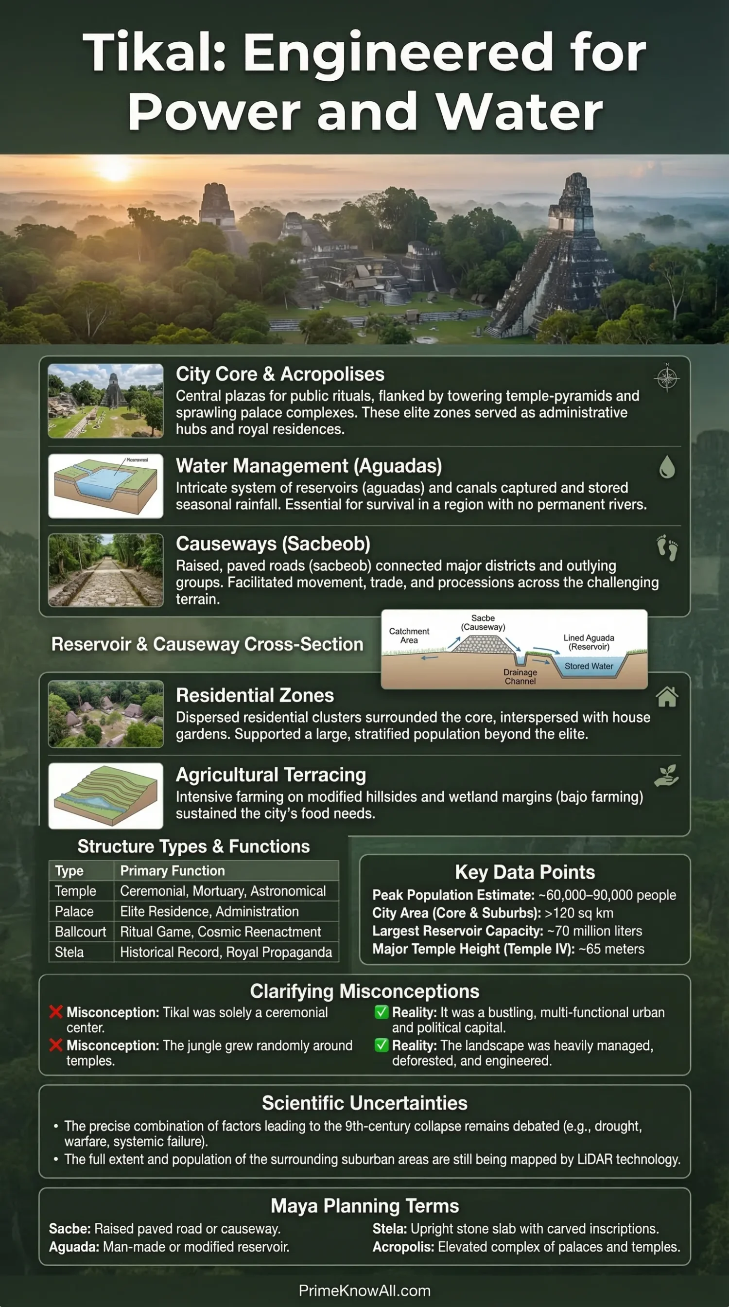
Ultra Short Answer: Tikal was a planned Maya city built around plazas, acropolises, reservoirs, and raised causeways, not a random spread of monuments. Its layout answered three practical needs at once: water storage, movement, and public power.
What Matters Most
- Tikal worked as a low-density city: homes, civic compounds, gardens, plazas, and water works spread across a broad area instead of packing into a tight street grid.
- Water shaped the plan. The site had no large river flowing through its monumental core, so the city stored rain in engineered reservoirs and directed runoff through plastered surfaces and channels.
- Movement was organized with sacbeob, or raised causeways, that linked major groups and guided people through ceremonial and administrative space.
- Monuments were political tools. The Great Plaza, the North Acropolis, the Central Acropolis, and later temple pyramids turned space into a public message about rank, memory, and dynastic rule.
- New mapping changed the picture. Airborne laser scanning across northern Guatemala showed that Maya urban life was denser and more connected than older jungle-floor maps suggested.
Tikal makes the most sense when it is read as a planned city in a seasonal forest, not just as a famous ruin. Its builders had to solve ordinary urban problems with the tools they had: where to place water, how to move crowds, how to separate elite space from daily living, and how to make power visible in stone.
That is why Tikal: Mayan city planning is really a story about design under limits. Limestone terrain, seasonal rainfall, social hierarchy, ritual needs, and long-distance politics all left marks on the city’s shape.
If you remember one thing, remember this: Tikal was planned from the ground up to manage water, movement, and authority together. The temples matter, but the city only comes into focus when the reservoirs, plazas, causeways, and residential groups are read as one system.
Why Tikal Matters in Maya Urban History
Short answer: Tikal matters because it shows that a Maya city could be large, ordered, and highly managed without looking like a gridded Mediterranean or Roman city. It grew over many centuries, especially from the Late Preclassic into the Classic period, and reached a scale that still shapes how scholars talk about low-density urbanism.
Tikal sits in the Petén region of present-day Guatemala. UNESCO added Tikal National Park to the World Heritage List in 1979, and the protected park covers about 57,600 hectares. Temple IV rises to roughly 65 meters, a reminder that the city’s builders were working at a monumental scale long before modern survey tools existed.
- Place: Petén Basin, a lowland tropical environment with marked wet and dry seasons.
- Time depth: occupation began long before the city’s best-known Classic-phase temples.
- Urban lesson: density at Tikal was spread through a wide managed landscape, not locked inside a rigid street grid.
How the City Was Organized
Short answer: Tikal was organized through linked ceremonial nodes, elevated compounds, residential clusters, reservoirs, and raised roads. The plan was not random. It was clustered, connected, and hierarchical.
A useful way to picture Tikal is to think of a large campus with several major hubs, not a downtown made from straight city blocks. The Great Plaza formed one public heart. The North Acropolis carried burial and dynastic memory. The Central Acropolis held elite and administrative functions. Other sectors, such as Mundo Perdido, added older ceremonial layers and long-term spatial continuity.
Ceremonial Core
The best-known part of Tikal is the ceremonial core, where Temple I and Temple II face each other across the Great Plaza. This pairing was not just beautiful staging. It created a controlled public arena where ritual, rulership, and crowd movement could be seen and managed at once.
- Great Plaza: public display and ceremony.
- North Acropolis: dynastic memory, tombs, and lineage display.
- Central Acropolis: elite residence and administration.
Residential Groups and Social Distance
Tikal was not made only of temples. Much of the city was built from residential compounds, patios, smaller platforms, workshops, and managed open land. A residential group is a cluster of buildings arranged around a shared courtyard. That layout supported family life, status marking, and daily work while keeping neighborhoods tied to larger civic spaces.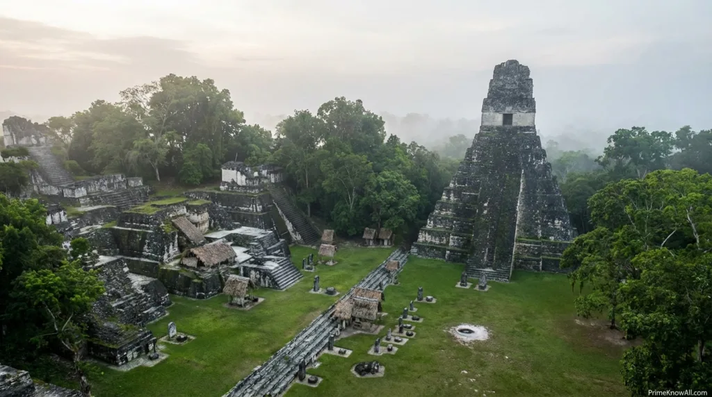
- Near the core: larger and more formal compounds, usually tied to higher rank.
- Farther out: more dispersed settlement, though still part of the urban fabric.
- Urban effect: the city felt spread out, but not unplanned.
Causeways as Controlled Movement
A sacbe, or causeway, is a raised stone road that linked major sectors. These routes helped people move across uneven terrain, but they also did social work. A causeway can guide processions, direct visitors toward public space, and connect districts without erasing status differences between them.
- Engineering role: stable movement across terrain and seasonal conditions.
- Political role: set routes through civic space.
- Urban role: tied distant groups into one city.
What To Keep in Mind Here
- Tikal did not need a modern-style street grid to be a real city.
- Plazas, acropolises, and causeways did the work that streets, squares, and civic corridors do in many later cities.
- The layout separated people by function and rank, while still binding the whole settlement together.
| Element | What It Did | Planning Value | What It Reveals |
|---|---|---|---|
| Great Plaza | Held ceremonies, gatherings, and public display | Created a central civic stage | Power at Tikal needed visibility |
| North Acropolis | Linked rulers to burials and ancestors | Fixed memory in a permanent place | Urban space carried dynastic history |
| Central Acropolis | Housed elite and administrative activity | Placed governance beside public ritual space | Rule and ceremony were closely tied |
| Causeways | Connected major groups and guided traffic | Made a dispersed city function as one | Movement itself was planned |
| Reservoirs | Stored rainwater for dry months | Made long-term occupation possible | Water was a planning problem from the start |
| Residential Patio Groups | Organized family life and local status | Created neighborhood-level order | The city extended well beyond its temples |
How Water Decided the Plan
Short answer: water was not a side issue at Tikal. It was one of the reasons the city could exist at all. The site had no large, reliable river running through its monumental heart, so rain capture and storage became a city-wide design task.
The Maya at Tikal used reservoirs, channels, embankments, and plastered collection surfaces to store seasonal rainfall. Plazas and roofs were not passive surfaces. They helped direct runoff. In urban terms, this was distributed infrastructure: many built elements contributing to one shared need.
One of the most striking findings from recent research is that the Corriental Reservoir appears to have used zeolite and quartz sand as a water-purifying medium. That matters because it shows planning at Tikal was not only about storage volume. It also involved water quality, at least in some places and periods.
- Dry-season pressure: stored water had to last beyond the rains.
- Engineering choice: plastered surfaces could speed runoff into managed basins.
- Urban lesson: in a seasonal environment, water works are part of city planning, not a separate utility.
How Power, Ritual, and Sightlines Shaped Space
Short answer: Tikal’s layout was practical, but it was also theatrical in a very controlled way. Plazas opened views. Temples framed movement. Elevated platforms marked rank. The city made authority visible.
In the Great Plaza, space worked like a public script. Tall temple pyramids, palace compounds, stairs, and open courts created a place where rulers could be seen and remembered. This was city planning with a social message. It told residents and visitors where power sat, who owned ceremonial time, and which places carried old royal memory.
Mundo Perdido, often called the Lost World complex, adds another layer. It is one of the city’s oldest monumental sectors and is often discussed as an E Group. An E Group is a Maya architectural arrangement often linked to solar observation and calendar display. Scholars do not agree on every detail of how such groups were used at every date, but the broad point is clear: orientation and sightlines mattered.
- Plazas: space for public gathering and staged authority.
- Temple axes: controlled how monuments faced one another.
- Elevated compounds: turned topography into social difference.
What This Section Adds
- Tikal’s public spaces were not empty gaps between buildings. They were working parts of political design.
- Water storage solved survival. Monument placement solved public meaning.
- That mix is why Tikal feels both practical and ceremonial at the same time.
A Simple Visual Model of Tikal’s Plan
Seasonal rain, dry months, and no large river in the ceremonial core meant the city had to store water on purpose.
Reservoirs, channels, embankments, plastered surfaces, and managed runoff turned rainfall into urban supply.
Great Plaza, acropolises, and temple groups created public order, dynastic memory, and controlled visibility.
Raised causeways linked major sectors so a spread-out settlement could still act like one city.
Residential patio groups extended the city far beyond its famous temples and gave daily life a local structure.
Tikal was planned as a connected urban landscape, where water, ritual, movement, and hierarchy were solved together rather than one by one.
What New Mapping Changed
Short answer: newer mapping, especially LiDAR, made Maya cities look less isolated and more connected. LiDAR, short for Light Detection and Ranging, is a remote-sensing method that can reveal ground features through forest cover. It has sharpened how Tikal is placed inside its wider landscape.
A major airborne laser scanning study across northern Guatemala identified more than 60,000 previously unrecorded structures across the surveyed region. That number is regional, not a count for Tikal alone, but it changed the conversation around Maya urbanism. It pushed scholars to see sites like Tikal as parts of dense, managed, and interconnected settlement systems.
For Tikal, that matters because older popular images often showed a ceremonial island in deep jungle. The newer picture is harder and more interesting: a city linked to fields, terraces, roads, smaller compounds, and other built features across a much broader lived landscape.
- Old image: isolated temple city.
- Better image: a node inside a managed urban and regional network.
- Planning lesson: the city should be read with its hinterland, not only with its postcard monuments.
Common Misconceptions
Short answer: the biggest mistakes come from reading Tikal as either only a ritual center or only a pile of temples. Both views miss how much everyday planning sat behind the stone skyline.
- Wrong: Tikal was a random cluster of monuments.
Correction: It was a planned city with ordered civic nodes, reservoirs, causeways, and residential groups.
Why this gets confused: famous photos focus on temple tops, not urban infrastructure. - Wrong: Maya cities had to look like tight gridded capitals to count as cities.
Correction: Tikal shows that a city can be low-density and still be highly organized.
Why this gets confused: many people use later European city forms as the default model. - Wrong: Water was a background issue.
Correction: Water storage shaped placement, scale, and survival.
Why this gets confused: tanks, channels, and reservoirs are less visually dramatic than pyramids. - Wrong: Every Maya site followed one master template.
Correction: Maya cities shared patterns, but each site answered local terrain, politics, and history in its own way.
Why this gets confused: textbook summaries flatten local differences. - Wrong: Astronomical alignment explains every building at Tikal.
Correction: Orientation mattered, but not every structure can be reduced to one sky-based purpose.
Why this gets confused: sky-related explanations are memorable, so they spread easily.
What To Hold On To After These Two Sections
- New mapping did not erase older excavation work. It expanded what the city seems to be.
- The most common reading error is to treat ritual architecture as the whole city.
- Tikal makes more sense when public monuments and ordinary infrastructure are read together.
How Tikal Planning Looks in Everyday Terms
Short answer: Tikal feels easier to understand when its design is translated into ordinary urban problems. This does not make the city modern. It simply makes its planning logic easier to see.
- Scenario: A city without a dependable river needs water through a long dry season.
Why this worked: Tikal answered that with stored rainfall, not with riverfront design. - Scenario: Large crowds must gather where rulers can be seen clearly.
Why this worked: The Great Plaza turned ritual into public staging. - Scenario: A spread-out settlement still needs linked movement routes.
Why this worked: Causeways gave the city durable connectors across its landscape. - Scenario: Elite government needs privacy but cannot be fully hidden from public life.
Why this worked: The Central Acropolis sat close to major ceremonial space without becoming ordinary public space. - Scenario: Family life needs local courtyards and repeatable house patterns.
Why this worked: Residential patio groups provided neighborhood order. - Scenario: A city wants memory built into its skyline.
Why this worked: The North Acropolis tied architecture to dynastic burial and ancestral legitimacy. - Scenario: Urban planners today talk about drought resilience and distributed systems.
Why this matters: Tikal offers an early example of resilience through storage, redundancy, and landscape design, even though the technology was entirely different.
What We Still Cannot Say With Full Confidence
Short answer: Tikal is well studied, but not every planning question has a final answer. Some debates stay open because the city changed over many centuries, excavation is uneven, and new methods keep adding evidence.
- Population: estimates vary widely. It is safer to say tens of thousands than to treat one number as settled fact.
- Astronomical intent: some alignments are persuasive, but not every orientation can be reduced to one fixed sky program.
- Water use over time: reservoirs did not all function in the same way during every phase of the city’s history.
- Neighborhood boundaries: mapping has improved, but social districts do not always leave clean lines in the ground.
This matters because good history is careful history. Tikal becomes more interesting, not less, when uncertainty is left visible. A measured reading is better than a neat but thin story.
What This Leaves You With
- Tikal was planned, but its plan was revised over centuries.
- The safest claims come from reading space, water, and movement together.
- Any exact figure on population or alignment should be treated with context, not as a slogan.
Read the Plan in One Pass
Tikal was a rain-managed, causeway-linked, monument-centered Maya city whose layout joined survival needs with public meaning. Its planning worked through reservoirs, plazas, acropolises, and residential compounds, not through a modern street grid.
The most common mistake is to study the temples and ignore the water and neighborhood system around them. Memorable rule: if a place at Tikal moves water, guides people, or frames visibility, it is part of the city plan.
Quick Test
Was Tikal planned like a modern grid city?
No. Tikal was planned, but not through a strict rectangular street grid. Its order came from plazas, elevated compounds, reservoirs, causeways, and linked residential groups. That is why scholars often describe it as a form of low-density urbanism.
Why were reservoirs so important at Tikal?
Because the city had to survive long dry periods without a large river crossing its ceremonial core. Stored rainfall was part of the city’s basic urban design. Some evidence even suggests water purification in at least one reservoir system.
Were the temples the whole city?
No. The temples are the most visible remains, but Tikal also included residential compounds, civic spaces, roads, and managed water works. Looking only at the monument tops gives a thin picture of how the city actually functioned.
Did astronomy shape the plan?
Partly, yes. Some architectural groups and sightlines are often linked to solar observation and calendar display. Still, it is safer to say that orientation mattered than to claim every structure had one fixed astronomical role.
What changed after LiDAR mapping?
LiDAR made the broader Maya landscape look denser and more connected than older maps suggested. For Tikal, that means the city is better understood as part of a wide, built, and managed regional system rather than a lone ceremonial island in the forest.
Sources
- UNESCO World Heritage Centre – Tikal National Park — Gives the official World Heritage listing, location context, inscription year, and protected park scale. Why reliable: UNESCO is the primary international record for World Heritage properties.
- Penn Museum – Tikal Project — Useful for excavation history, architecture, and long-term archaeological work at the site. Why reliable: It comes from a museum institution directly involved in Maya research.
- Smarthistory – Tikal, Guatemala — Offers a clear scholarly summary of the site’s major buildings and historical setting. Why reliable: Smarthistory is a widely used educational resource written and reviewed by subject specialists.
- Scientific Reports – Early Water Purification at Tikal, Guatemala — Supports the point about zeolite and quartz-based filtration at the Corriental Reservoir. Why reliable: This is a peer-reviewed research article in a major scientific journal.
- Science – Ancient Lowland Maya Complexity as Revealed by Airborne Laser Scanning of Northern Guatemala — Supports the regional LiDAR finding that reshaped debate on Maya settlement density and connectivity. Why reliable: Science is a leading peer-reviewed journal, and this article is one of the best-known LiDAR studies for the Maya lowlands.
- Encyclopaedia Britannica – Tikal — Helpful for cross-checking core historical facts, location, and broad chronology. Why reliable: Britannica is a long-standing reference source with editorial review.
FAQ
What made Tikal a city rather than just a ceremonial center?
Tikal included public monuments, elite compounds, residential groups, water systems, and transport routes. That mix is what gives it a true urban character.
How did Tikal get enough water?
The city stored seasonal rainfall in reservoirs and directed runoff through built surfaces and channels. Water planning was part of the city’s basic design.
What is a sacbe in Maya archaeology?
A sacbe is a raised stone causeway. At Tikal, causeways linked major sectors and helped a broad settlement work as a connected city.
Did Tikal have neighborhoods?
Yes. Residential patio groups created local living units around shared courts, and these clusters helped organize daily life beyond the ceremonial core.
Why do scholars call Tikal low-density urbanism?
Because the city spread across a wide landscape with many compounds, open spaces, and managed infrastructure rather than compressing everyone into tight city blocks.
Did LiDAR change what we know about Tikal?
It sharpened the wider picture. LiDAR did not replace excavation, but it helped reveal how connected and built-up the surrounding Maya landscape really was.
