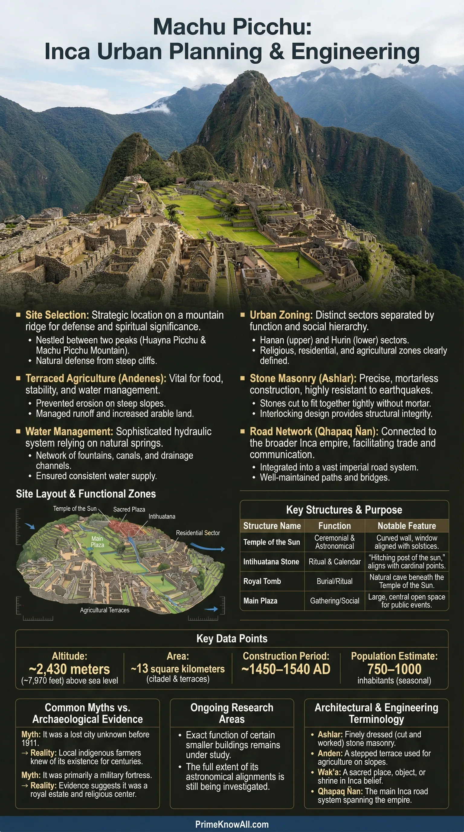
Machu Picchu is often described as a lost city, but its real power comes from something more practical: planning. Perched on a narrow Andean ridge about 2,430 meters above sea level, the site reads like a carefully engineered blueprint where terrain, water, agriculture, and social space are designed to work as one system.
Machu Picchu In Its Landscape
Machu Picchu sits above a dramatic bend of the Urubamba River, with steep drops on multiple sides. This is not a random scenic choice. A ridge offers control of access, strong sightlines, and cooler temperatures than higher Andean plateaus, while still staying close to fertile valleys. The result is a site that feels both protected and connected, a key balance in Inca territorial design.
The location also forces design discipline. Flat land is scarce, rain can be heavy, and slopes fail when water is unmanaged. That pressure shaped a planning approach that treats landform as the main structural guide. Instead of forcing a grid onto the mountain, Inca builders created a stepped city where every wall and platform helps solve a physical problem.
What Urban Planning Meant For The Inca World
Calling Machu Picchu “urban” does not mean it functioned like a modern city. Many scholars describe it as a royal estate with ceremonial and administrative roles. Still, the place uses classic tools of urban planning: zoning, infrastructure, circulation, and public space. The plan organizes people and activities in ways that feel deliberate rather than accidental.
Inca planning typically aimed to do several things at once: keep the settlement self-sustaining, manage water, express status through space, and support ritual life without separating it from daily function. At Machu Picchu, those goals overlap so tightly that “engineering” and “architecture” are hard to separate.
Two Main Sectors: Productive Slopes And Built Core
A simple way to read Machu Picchu is to see it as two interlocked parts: the agricultural terraces and the urban precinct. The terraces are not just farmland. They are structural and hydrological devices that stabilize slopes and guide water. Above and within them, the built area concentrates housing, storage, ceremony, and administration in compact clusters linked by paths and stairs.
| Planning Element | Main Purpose | What It Looks Like On The Ground |
|---|---|---|
| Agricultural Terraces | Slope stability and food production | Layered retaining walls, stepped fields, controlled runoff |
| Water Supply Line | Reliable drinking water | Captured spring, canal, and a sequence of fountains |
| Drainage Network | Rain management and erosion control | Stone fills, outlets, and permeable layers under plazas and terraces |
| Residential Compounds | Household organization and social separation | Courtyard-centered blocks with controlled entries and shared work space |
| Ceremonial Nodes | Ritual and political symbolism | Temples, sacred stones, and focal viewpoints tied to the landscape |
| Circulation Spine | Movement and crowd control | Stairs, ramps, gates, and narrow passages guiding flow |
Terraces As Infrastructure, Not Decoration
The terraces show how Inca planning treats agriculture as part of the city’s engineered base. Their retaining walls create level planting beds, but they also reduce landslide risk by breaking the slope into smaller, controlled steps. Behind those walls, builders used layered fills that help move water through the ground rather than letting it pool. That makes the terraces a stability system as much as a food system.
This approach also creates a clear boundary between productive land and the built core. The transition is intentional: as someone moves upward from terraces to plazas and buildings, the space shifts from work to gathering to ritual. That is zoning, expressed with stone and elevation instead of signs.
Courtyards, Blocks, And Controlled Access
Many buildings are organized into compounds around a central courtyard, a form that supports shared tasks while keeping clear edges. These blocks create micro-neighborhoods: semi-private spaces for daily life, surrounded by thick walls and narrow entries that make movement easy to monitor. It is a compact layout that keeps distances short and reduces the need for wide streets.
Space also signals status. Some structures use finer stonework and sit closer to major plazas or ceremonial areas. Other zones appear more utilitarian, likely tied to storage, service work, or temporary residence. The plan does not flatten social differences; it maps them onto the site in a way that is readable without written labels.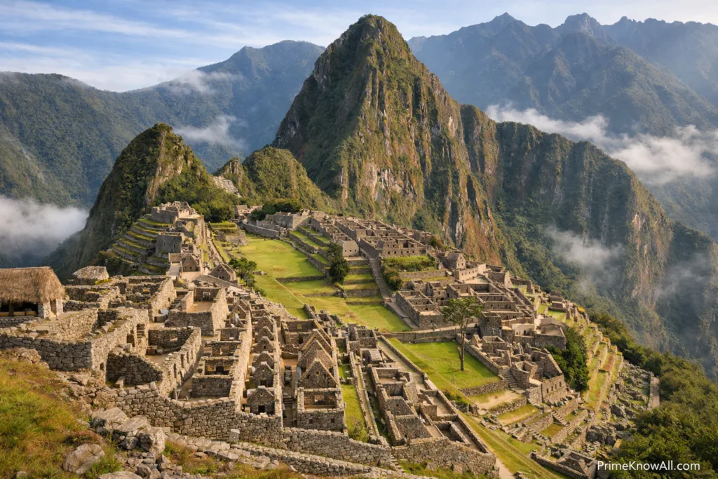
Circulation: Paths That Shape Behavior
Machu Picchu’s “streets” are mostly paths, stairs, and short connectors rather than long avenues. This creates a network that can be fast for locals but slow for crowds. Narrow passages naturally regulate flow, while small gateways define thresholds between spaces that feel public, semi-public, and restricted. In urban terms, it is access management built into the geometry.
Vertical movement is the real organizing principle. Stairs are not an afterthought; they are the city’s connective tissue. Each climb changes perspective, temperature, and view, turning circulation into an experience of sequence. That matters in a place where ritual and authority were often expressed through procession and controlled approach.
Water Planning: Supply, Fountains, And Hidden Drainage
On a rainy mountain ridge, the hardest job is not finding water. It is making water predictable. Engineering studies describe a system that captures a natural spring, channels it along a stone-lined route, and distributes it through a series of fountains. Reported spring flow varies by season, but it is commonly described in the tens to low hundreds of liters per minute, enough to support a managed domestic supply when paired with careful use.
Equally important is what visitors rarely notice: drainage. With annual rainfall often described around 2,000 mm in the region, unmanaged runoff would destroy terraces, undermine foundations, and turn plazas into mud. The site uses permeable fills, stone channels, and outlets to move water away from structures. In modern terms, it is a blend of stormwater design and geotechnical planning, executed with stone, gravel, and slope logic.
A useful way to “see” the plan: If the architecture feels unusually intact for a mountaintop site, drainage is a major reason. Much of Machu Picchu’s planning is underground or inside terrace fills, working quietly to keep stone and soil stable.
Stonework And Seismic Sense
Machu Picchu is famous for dry-stone masonry, where precisely shaped blocks fit without mortar. This technique is not just aesthetic. In earthquake-prone terrain, flexible joints can perform better than rigid mortar bonds. Planning here includes material strategy: building with stone that can tolerate movement while maintaining structural integrity. The outcome is a city that feels tight and durable even after centuries of exposure.
The builders also worked with what the ridge provided. Local stone was quarried and shaped on-site, reducing transport burden in steep country. Walls, terraces, and stairways share a consistent construction logic, suggesting a coordinated plan rather than piecemeal additions. That unity is a hallmark of urban design: repeated rules that keep the whole settlement coherent.
Public Space: Plazas, Vistas, And Social Meaning
Even in a compact mountain layout, Machu Picchu makes room for open space. Plazas and clearings work as gathering points and visual anchors. They also provide planning benefits: they are orientation devices in a dense site, helping people navigate by recognizable nodes rather than street names. The ridge itself becomes part of the design, with views that reinforce a sense of place and ritual setting.
In Inca contexts, landscape was not just scenery. Mountains, peaks, and unusual rock forms could be treated as sacred. Machu Picchu’s plan repeatedly frames the surrounding terrain, almost like an architectural storyboard. That framing is a planning choice: it aligns movement and gathering with what the society considered meaningful.
Ritual Geometry And Astronomical Attention
Ceremonial structures and carved stones suggest that Machu Picchu’s plan includes deliberate alignments. Some features are often discussed in relation to solar events and seasonal change, though interpretations vary and should be treated carefully. What is more certain is the broader planning idea: key points are placed where light, shadow, and horizon become part of the built experience.
That matters because calendars were not abstract. In agrarian societies, seasonal timing is tied to planting, harvest, and political ritual. When architecture helps make time visible, it becomes a form of public infrastructure for shared schedules and collective meaning.
Planning Principles You Can Extract From The Site
Machu Picchu is often admired as a marvel, but it is even more interesting as a set of planning rules. These principles can be described without romantic language, because they are visible in the way the city fits the ridge.
- Start with the landform: terraces and platforms make the slope usable without pretending it is flat.
- Treat water as the first utility: capture, distribute, and drain it before refining architecture.
- Zone by elevation and thresholds: transitions are marked with stairs, gates, and shifts in openness.
- Use repeated building logic: consistent wall and courtyard patterns keep the settlement legible.
- Design movement to shape behavior: narrow routes and nodes control flow without heavy barriers.
This is why Machu Picchu is more than an archaeological site. It demonstrates how a society can build a dense settlement that feels ordered, stays stable on extreme terrain, and integrates food, water, and symbolic space into one plan.
Sources
UNESCO World Heritage Centre – Historic Sanctuary of Machu Picchu (List 274) [World Heritage description and significance, including the site’s planned organization]
Encyclopaedia Britannica – Machu Picchu [Concise background on chronology, function, and core features]
MDPI Water – The Masterful Water Engineers of Machu Picchu [Research overview of water capture, fountains, and drainage engineering]
University of Wisconsin–Madison – Machu Picchu Water Management [Educational resource explaining the site’s water planning concepts]
Smarthistory – Machu Picchu [Context on layout, function, and architectural organization]
FAQ
Was Machu Picchu a real city or a royal estate?
Many researchers describe it as a royal estate with administrative and ceremonial functions rather than a dense, permanently populated city. Still, its layout uses urban planning tools such as zoning, infrastructure, and public space, which is why it can be analyzed as an urban plan.
Why are the agricultural terraces considered part of the planning system?
The terraces are structural and hydrological devices. They stabilize steep slopes, manage runoff, and create usable planting surfaces. In Machu Picchu’s design, agriculture and engineering are tightly linked.
How did Machu Picchu get reliable water on a mountain ridge?
The settlement uses a managed system that captures a spring, conveys water via a channel, and distributes it through a sequence of fountains. Planning also prioritizes drainage so heavy rain does not undermine terraces, plazas, or foundations.
What makes the site’s circulation feel so controlled?
Movement is shaped by stairs, narrow connectors, and gateways that define thresholds. This creates a network that guides flow through nodes and sequences, separating open gathering areas from more restricted precincts without needing modern barriers.
Did Inca planners design Machu Picchu around astronomy?
Some features are often discussed in relation to solar events and horizon observation, but interpretations can vary. What is clear is that the plan places key structures and stones to interact with light, shadow, and landscape, making celestial attention part of the architectural experience.
Article Revision History
